
|
|
Mountain/Rock |
|---|---|
|
|
38.38400°N / 119.667°W |
|
|
Hiking |
|
|
Summer, Fall |
|
|
11233 ft / 3424 m |
|
|
Overview
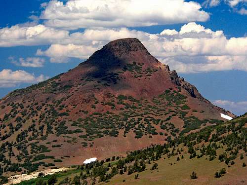
Stanislaus Peak is a red colored ancient volcanic cone located above Sonora Pass on California State Route 108, one of the Trans-Sierra routes that is closed during the winter. There are a few 11,000 ft. peaks in the area that can be summited in a day or less with Leavitt Peak to the south being the highest. Stanislaus Peak is a sharp landmark for those traveling the Pacific Crest Trail (PCT). The summit itself is well-removed from the PCT, but makes for a good side trip.
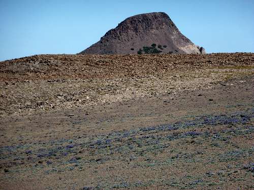
The primary route to the summit is via the Southeast ridge, heading right up the east side of the south face. It isn't technical, but it is a lung and calf buster. The summit itself is very flat and covered with flat rocks that reminds one of roof tiles both by look and the clinky sound they make as you walk on them. Reaching the summit requires a moderate class 2 non-technical climb that can be combined with Sonora Peak to the south for a nice day of hiking.
Do not be surprised by men in uniform. This area is used by the United States Marine Corps for mountain warfare training. The main base is about 10 miles east of Sonora Pass on State Route 108. From Stanislaus Peak one can see Round Top and Highland Peak to the north, Leavitt Peak and the Emigrant Wilderness to the south, and the Dardanelle Cones to the west.
 |
 |
 |
 |
 |
Getting There
The main trailhead is located at the St. Mary Pass parking area on the north side of the road 0.8 mile west of the Sonora Pass summit. It is located approximately 60 miles east of Sonora, CA along California State Route 108. The turn off is easy to miss because there is no sign. However, this is the trailhead, and it's quite a popular one.
 |
 |
Red Tape
There are no permits required for day hiking in the Carson - Iceberg Wilderness or for parking at the trailhead. If one is camping, a Wilderness Permit is needed. An online permit form for a Wilderness Permit is a available. Permits can also be obtained from any Stanislaus National Forest Ranger Office including the Mi Wok and Summit Ranger Stations offices located along CA State Route 108 en route to Sonora Pass from the west. Only one permit is needed for continuous trips passing through more than one wilderness area. If you plan on using a stove, even if on a day hike, a fire permit is required and can be picked up at any U.S. Forest Service office. The fire permit is good for the entire state of California.
When To Climb
The best time to climb is June (if the snow is not too deep) through October. State Route 108 is closed 7 miles east of Strawberry from the first significant snowfall in the fall to a spring opening. Memorial Day weekend is the usual target date for opening the pass. Some years it is earlier and some years later. The summit log had entries as late as the first part of November and as early as mid-May.
Camping
Camping is allowed in the Carson - Iceberg Wilderness with the proper permit. Use a bear proof canister in the back country. To the west of the summit are several Forest Service campgrounds that have free camping. The catch is there is no water available, so bring plenty. Down from the pass in both directions are regular Forest Service fee campgrounds. The closest being Kennedy Meadows to the west and Leavitt Meadows to the east. There is also a store and restaurant fairly close to the west of the pass at Kennedy Meadows and at Dardanelles.
Mountain Conditions
Current highway conditions can be found on the Caltrans website or by phoning the California Department of Transportation road condition line at 1-800-427-7623. General area conditions can be found by phoning any Stanislaus National Forest Ranger Station.
Etymology
"An expedition under Gabriel Moraga discovered the river in October 1806 and name it Rio de Nuestra Senora de Guadalupe. (Arch. MSB, vol. 4, Munoz, Oct. 2, 1806.) It was on this river, the next day, that they found the rancheria of the 'Taulamne' Indians, but the name 'Tuolumne' wound up on the next river south. Estanislao was an Indian, born at Mission San Jose, baptised, and given a saint's name -- probably for one of the two Polish saints called Saint Stanislas. Estanislao ran away from the mission -- inducing some other converted Indians to leave with him -- and became a rebel. The Mexicans, under Gen. Vallejo, defeated Estanislao in two battles in May and June of 1829. (Gudde, Place Names, 320; Historic Spots, 368, 539.) The river later became known as Rio Estanislao, and was anglicized into 'Stanislaus River' by Fremont in 1844. (Fremont, Expeditions, 359.) The peak was named in the middle 1870s. In 1877 Lt. Macomb climbed it and found 'a fine monument erected by a reconnaisance party of the Coast Survey.' (Wheeler Survey, Report, May 1, 1878, 143.) The name is on atlas sheet 56D, 1878-79. Thus, by a series of unlikely events, the name of a Polish saint was given to a mountain in Apline County, California." - Peter Browning, Place Names of the Sierra Nevada
External Links
Sonora/Stanislaus dayhike - Aug 16, 2002
LincolnB - Sep 17, 2011 11:17 am - Hasn't voted
ParkingSlight correction -- St Mary's pass parking is 0.8 miles from the summit (not 0.5 miles) and is south of the road (not north). The trailhead is north of the road.
keema - Sep 18, 2011 10:40 am - Hasn't voted
Re: ParkingI've always parked north of the road. I was up there Labor Day weekend and parked north of the road along with 4 other cars.