
|
|
Mountain/Rock |
|---|---|
|
|
46.05572°N / 7.74171°E |
|
|
11174 ft / 3406 m |
|
|
Overview
..
.
.
.
.
.
.
.
*
Mettelhorn is a bleak shadow in this area where nine of the ten highest mountain in The Alps is situated.
However, we all need training, spots for acclimatization and sideshows.
 NORTH FACE
 VIEW FROM PLATTHORN
Getting There
From the airports in Milan, Geneve or Zürich it takes 3-5 hours with train or car to Zermatt 1600m.From this carfree village we are walking northwest. The ascent is 1800 meters, 4 –6 hours on good stony slope and with a small safe glacier under the peak. On the way up you pass a cosy restaurant at Alterhaupt 1900 m, and another at Trift at 2300 m.
Tad wrote:
A much nicer alternative for this hike is to take a trail that begins at the northern end of the railway station. Cross the tracks to the west and take the trail going diagonally north up the western (i.e., east-facing) slope of the valley. The trail continues in switchbacks between small clifs first in the general north-west direction, and then back south-west. Soon after you pass through the first zone of anti-avalanche barriers you come to a flatter place at about 2400 m where you meet a wider trail coming from Trift. There is a sign there pointing to Zermatt (where you came from) and Trift (ahead, slightly down); you take the third trail to the right (NOT indicated on the sign). That goes first diagonally to the north and after a few hundred meters switches back to the south-west, reaching the lower-south edge of another zone of avalanche barriers. From there (about 2600 m) the trail traverses horizontally west , after about 800 meters you cross a stream and join the trail coming from Trift.
The views most of the way are superb, in contrast to the route through Trift which follows a gorge and has very limited view.
  |
Red Tape
No red tape.When To Climb
June-October. ON TOP
 BETWEEN METTELHORN AND PLATTHORN
Camping
Camping is allowed all over, but don´t put up your tents to close to Zermatt or to the cottages in the mountains. It is 115 (!) hotels in Zermatt.Mountain Conditions
 HIKING UP
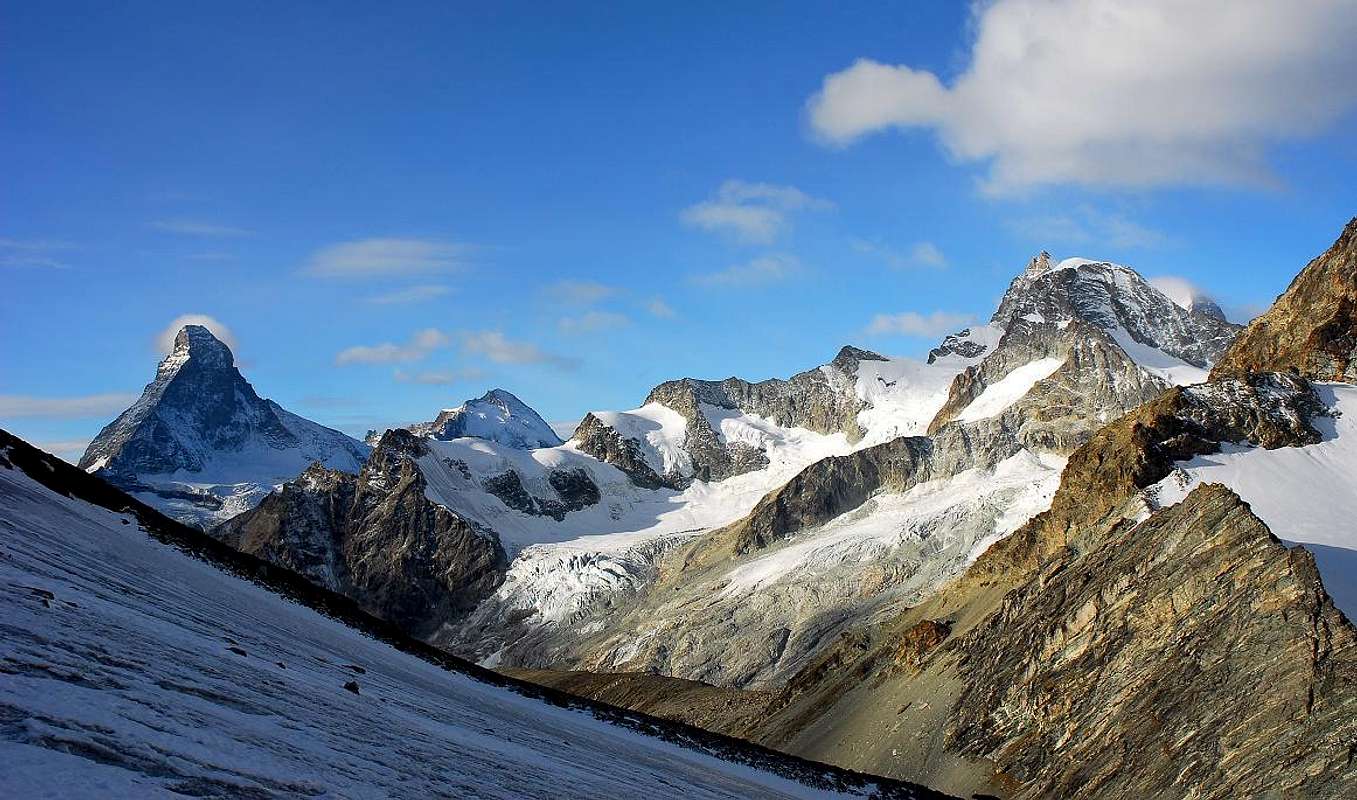
Breithorn-Matterhorn
WEATHER-REPORT:
Alpenverein
SLF
Phone from abroad: ++411162
Zermatt-Weather
All kind of information:
Zermatt
Alagna
Maps and books
Schweizer Landeskarten:1:25000 no. 1348 Zermatt
1:50000 no. 5006 Matterhorn-Mischabel
1:50000 no. 284 Mischabel
1:50000 no. 294 Gressoney
(to order at DAV Service)
BOOKS
Hermann Biner, Hochtouren im Wallis. Vom Trient zum Nufenenpass. 2nd ed. 1996.
ISBN 3-859022-160-5
Helmut Dumler/Willi P. Burkhardt, The High Mountains of the Alps. 1994.
(to order at amazon.com)
ISBN 0898863783
Helmut Dumler/Willi P. Burkhardt, Viertausender der Alpen. 11th ed. Munich 1998.
ISBN 3-7633-7427-2
Michael Waeber, Walliser Alpen. DAV-Gebietsführer. 12th ed. Munich 1999.
ISBN 3-7633-2416-X
Michel Vaucher, Walliser Alpen. Die 100 schönsten Touren. 2nd ed. Munich 1990.
ISBN 3-7654-2124-3