
-
 11442 Hits
-
 82.48% Score
-
 15 Votes
|
|
Mountain/Rock |
|---|---|
|
|
46.99330°N / 13.53650°E |
|
|
Hiking, Skiing |
|
|
Spring, Summer, Fall, Winter |
|
|
7775 ft / 2370 m |
|
|
Overview
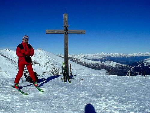
On the summit of Stubeck

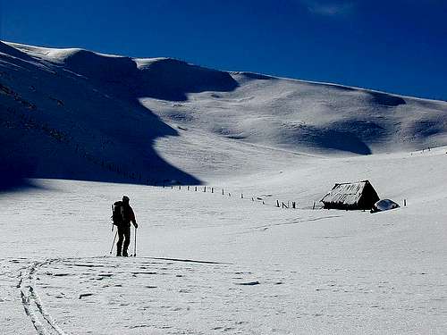
Stubeck from the north
What's New Here?
> Jan 24th, 2019: Design corrections.
> Oct 29th, 2014: Images added, new design.
> Nov 24th, 2004: Initial page setup.
Stubeck Gets Presented
Although Stubeck belongs to Hohe Tauern it resembles by its rounded and hilly shape more to Nockberge, which are stretching across the Lieser valley. Still, this stand-alone mountain is very interesting for ascending, especially in times of tour skiing. The upper part of the mountain is rocky and grassy, a bit below, many alpine pastures can be seen, further below, the mountain is covered with forests. Also the landscape in the lower and mid altitudes is very exploited. From the Villach-Salzburg highway, passing by on its eastern part, you can see many villages, farms, roads and cart-roads ascending up the hill.
To the rest of Hohe Tauern main chain Stubeck is attached on NW with the saddle, named Torscharte, 2106 m. Towards the north, mountain slopes are falling down to Wolfs Bach (creek), towards the east to Lieser valley, towards the south to Malta valley and towards the west to Feistritz Bach (creek). One additional 'advantage' is the road, which ascends over the southern slopes from Malta to the altitude of 1600 meters. It is cleaned quite early in spring, enabling you to do an easy and short ski tour. Having your car so high, can also be a disadvantage - or at least for the one poor person, who is driving. Others can ski also further down. In summer and autimn, Stubeck is nice for hiking and also for mountain biking.
Getting There
Maltaberg
For the general orientation see the Hohe Tauern and Ankogel Group pages.
To approach Stubeck the most convenient is the Villach-Salzburg highway. You exit either in Rennweg below Katschberg (for the north approach) or Gmuend (for the southwestern approach). Besides the mentioned two approaches, the mountain can also be ascended directly from Lieser valley, but in this case you must do some 1200 m of altitude. In this case you use the local road, which goes parallel to the highway.
For the northern approach, you drive from Rennweg NW to St. Peter (1 km) and from there into the Wolfs Bach valley. A narrow forrest road brings you to the altitude of 1728 m (Wansinghuette) - but only in summer. In winter and early spring the road might not be cleaned.
For the southeastern approach, drive from Gmuend town into Malta valley to the village Malta. Deter into the village, drive through it and all the way towards the north - in many turns by the southern slopes of Stubeck. You can park by Kramerhuette, 1600 m. Because it's so sunny, this road is cleaned quite early in spring.
The popularity of Stubeck for skiing is shown also by the fact, that from Frido-Kordon Huette to the very summit a 'Gipfeltaxi' (summit-taxi) is driving.
On the web, you can see a detailed map on: http://www.austrianmap.at/.
Routes Overview
Summer routes
1. You can reach Stubeck's south ridge either from Kramer Huette, 1604 m, or from Frido-Kordon Huette, 1640 m. Paths to the summit are marked and easy. From Kramer Huette you go by a well marked path towards the north-east, crossing first nice alpine meadows, then ascending through larch woods. On the altitude just above 2000 m, you hit the cart road, coming from the right and continuing towards Gmeinalm. But you just cross the road and continue upwards to the summit of Stubeck. Some 2 h to the top, all the time easy, marked path (T2).
2. From the north, you go from Wansing Huette towards the SW to Torscharte (saddle), 2106 m, and from there by the NW ridge to the summit. Also marked (the NW ridge ?) and easy, (T2).
3. From the east and southeast you start in villages or hamlets above the Lieser valley. Marked are routes over Lupbauerhuette, 1700 m, and Boden, 1731 m.

2. From the south, you can start the tour either by Frido-Kordon Huette or by Kramerhuette. It takes you some 2 h to ascend the summit. From Kramerhuette you best walk by a cart-road in the valley, called In der Faschaun (the valley of Feistritz Bach). Reaching alpine meadows, you turn right and ascend over the western slopes the South ridge of Stubeck. Then to the summit. From here, from the west, you can easily choose the route of ascent and descent. It's only not recommendable to go with skis directly on the Torscharte (saddle). There are some steep sections. The other option from the south is to ascend the south ridge from any of the two huts earlier. Then just follow the ridge to the summit. Towards the southern trailheads, you can ski down almost everywhere - as described for ascents.
In hard winter you can start the south tour also down in Malta valley.
Red Tape
No restrictions.
When To Climb
You can ascend Stubeck any time of season.
For weather conditions for Austria see here (then choose region: Kaernten).
Camping
- Lippbauerhuette, 1700 m. Private. Contact: Hermine Steiner, Unterburgstallberg 8, A 9862 Kremsbrücke, Austria. Tel. & Fax: (04735) 575.
- Wansinghuette, 1728 m. Private. 6 beds. Contact: Hans Meißnitzer, St. Peter 25, A-9863 Rennweg/Katschberg, Austria.
- Kramerhuette, 1600 m. Private. Contact: Ferdinand Fladnitzer, Malta 168, A-9854 Malta, Austria.
- Frido-Kordon Huette, 1640 m, Austrian Alpine Club - Section Gmuend. Opened from start of May till mid October, 10+15 beds. Tel.: +43/4733/528.