

|
|
Mountain/Rock |
|---|---|
|
|
38.54390°N / 119.7555°W |
|
|
Hiking |
|
|
Summer, Fall |
|
|
10935 ft / 3333 m |
|
|
Overview
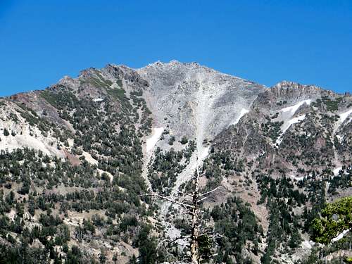
Highland Peak is a sharp summited peak located near Ebbetts Pass on California State Route 4, one of the trans-Sierra routes that is closed during the winter. There are quite a few peaks to hike in the area, but Highland Peak is the highest, and it has a prominence of nearly 2,500'. Highland Peak has a broken granite summit located south of the pass in the Carson - Iceberg Wilderness and is a nice side trip for those traveling the Pacific Crest Trail. From Highland Peak one can see Round Top to the north, Stanislaus Peak, Leavitt Peak and the Sonora Pass area to the south, and the Dardanelle Cones to the southwest. S.R. 4 is a very narrow and winding road making it much more lightly traveled than the other Trans-Sierra highways. This means Highland Peak is not as often visited as some of the other peaks just off Trans-Sierra roads.
Interestingly enough, Highland Peak is located further east than other major Sierra peaks, and as a result it is widely visible from far to the north, including from the Mt. Rose Highway in Reno. It appears quite close from Carson City and Minden as well, even though it is still a decent drive to get there from those communities.
Highland Peak can be combined with Silver Peak, which is along the same ridge and a little under 2 miles to the north. Most people also hike the south peak of Highland Peak, which is 10,824' and has a prominence of over 280'. The route up toe Highland Peak crosses just under the summit of the south peak, so it is worthwhile to hit both summits.
 |
 |
 |
 |
Getting There
The main trailhead is the Pacific Crest Trail parking area on the south side of the road 0.5 mile east of the Ebbetts Pass summit. It is located approximately 60 miles east of Angels Camp, CA along California State Route 4. This route follows the PCT to Noble Lake and then up to the mountain.
There is a second trailhead (Noble Canyon Trail) near the Silver Creek Campground. This can be used for a longer approach to Highland Peak via Noble Lake (1 mile longer than the standard route from the PCT via Ebbetts Pass) or can be used to bushwhack up one of the ribs leading to the summit ridge. Bushwhacking is a little shorter, but it much steeper and is not recommended for Highland Peak, given the standard route is far easier.
Red Tape
There are no permits required for day hiking in the Carson - Iceberg Wilderness or for parking at the trailhead. If one is camping, a Wilderness Permit is needed and can be ordered from any Stanislaus National Forest Ranger office or picked up at the Office in Hathaway Pines, or on their website. Only one permit is needed for continuous trips passing through more than one wilderness area. If you plan on using a stove, even if on a day hike, a fire permit is required and can be picked up at any U.S. Forest Service office. The fire permit is good for the entire state of California. There are no wood fires allowed above 9000 ft.
When To Climb
The best time to climb is June (if the snow is not too deep) through early October. State Route 4 is closed just west of Lake Alpine from the first significant snowfall in the fall to a spring opening. Memorial Day weekend is the usual target date for opening the pass. Some years it is earlier and some years later.
Camping
Camping is allowed in the Carson - Iceberg Wilderness with the proper permit. Use a bear proof canister in the backcountry. To the west of the summit are several Forest Service campgrounds that have free camping. The catch is there is no water available, so bring plenty. Down from the pass in both directions are regular Forest Service fee campgrounds. The closest being Lake Alpine to the west and Silver Creek to the east. There is also a store and restaurant fairly close to the west of the pass at Lake Alpine and Bear Valley.
Mountain Conditions
Highway conditions can be found at Caltrans online by searching for Highway 4 or SR 88, or by phoning the California Department of Transportation road condition line at 1-800-427-7623.
Etymology
"'... we occupied the important points in the neighboring mass of mountains, that nearest the town [Silver Mountain City] being known as Silver Mountain. We named the loftiest point ... Highland Peak.' (Wheeler Survey, Report of Lt. Macomb, 1878, 142.)"
- Peter Browning, Place Names of the Sierra Nevada