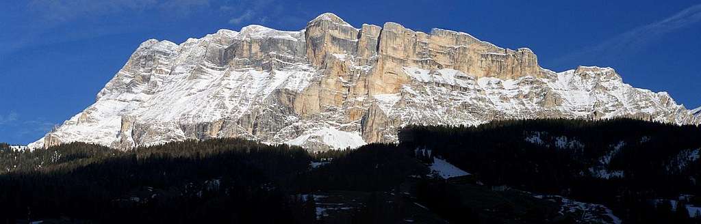
Sass dla Crusc - in Ladin dialect (Sasso della Croce in Italian, Heiligkreuzkofel in German) - is a long ridge dominating the West side of Val Badia with very steep high walls and well marked pillars of "dolomia". It runs between Sass da les Diisc (Zehner - 3026 m) to the left (North) - if seen from Val Badia - and Forcella de Medesc to the right (South), making a quarter of a circle clockwise. Sass dla Crusc belongs to the Cunturines, a Dolomites' Group located between Val Badia and Valle di San Cassiano to the West, Val Marebbe to the North-East and Val Travenanzes to the South-East.
Sass dla Crusc from West - Photo Gabriele
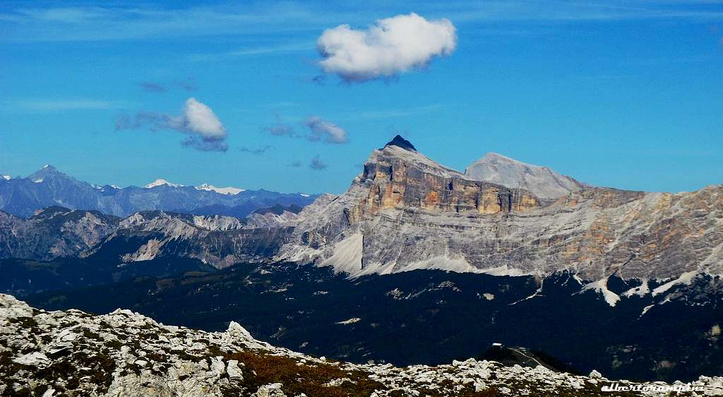
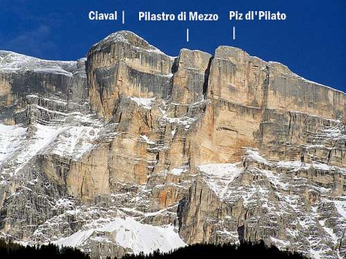
The mountain has some summits that can be seen as well distinguished only from the West side (Val Badia), due to the fact that the ridge when seen from the East side is rather uniform and gently descending with easy slopes towards Rif. La Varella and Rif. Fànes. This summits are Piz dl' Ciaval (Monte Cavallo - 2907 m.) - Pilastro di Mezzo - Piz dl' Pilato (2825 m.) - Piz dl' Zübr (Piz del Mastello - 2718 m.) - Pergo dla Forcela (2658 m.) and Piz dl'Ciantun.
Santa Croce / Heiligkreuz sanctuary
Coming storm over Sass dla Crusc
From East the summits can be easily reached from Rifugio Fanes or Rifugio La Varella through a wide basin called Pices Fanès. From West the summits can be reached by a long walk, then a "Via Ferrata", starting from Pedràces. The West side is a big vertical wall drop up to 650 m and has many of the most difficult climbing routes of the area.
Sass dla Crusc West wall
Sass dla Crusc summit ridge
Sass dla Crusc Diedro Mayerl
Getting There
The starting point to climb the stunning West face of Sass dla Crusc is the village of Pedràces m. 1330 in upper Val Badia. Pedràces is also the base to get the summit via the Normal Route starting from Ospizio Santa Croce (Via Ferrata). The starting point to get the summit via the Normal route through Pices Fanès is Rifugio La Varella or Rifugio Fanes.
Road access to Pedràces
- From Bolzano: take the Brennero Motorway A22 towards North, exit Ponte Gardena and then follow the road SS242 up the Val Gardena to Passo Gardena and down to Corvara. In Corvara follow on the left signs for La Villa - Pedraces. At Pedraces take the chairlift on the right to the refuge and church Santa Croce, from where the path leads off to the base of the routes.
Sass dla Crusc from Val Badia
- From Passo del Brennero (Brennerpass): follow the Brennero Motorway A22 towards South, exit to Bressanone and then follow the road SS 49 (E66) up the Val Pusteria, getting to San Lorenzo, a few km. before Brunico. Here leave the main road SS 49 and take the road SS 244 up the Val Badia to Pedràces.
- From Venezia-Mestre-Treviso follow the A27 Motorway, exit Belluno, then take the road SS51 to Cortina d'Ampezzo, Passo Falzarego, Passo Valparola e Alta Badia, getting to Corvara. In Corvara follow on the left the signs to La Villa - Pedraces. In Pedraces take the chairlift on the right to the refuge and church Santa Croce, from where the path leads off to the base of the routes.
Sass dla Crusc from Col de Stagn
Accessing by hiking is easy and comfortable from Rif. Fanes (2050m) that can be reached in many ways, the shortest is coming Val Badia and crossing San Vigilio di Marebbe and Tamores till Rifugio Pederu 1548m). From here on foot, mountain bike or taxi service till Fanes. Rifugio Fanes can be reached also, with a wonderful (but not short) walk, starting from Armentarola (on the road from San Cassiano to Passo di Val Parola and Passo Falzarego) and crossing Col dla Locia (between Cunturines and Cima del Lago). For the Western wall climbs the starting point is the Abbazia dla S.Crusc that can be reached from Pedraces by foot or by a chair-lift.
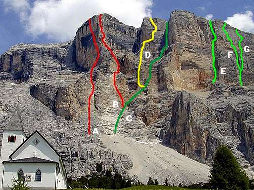
West face routes overview
Sass dla Crusc Central walls
CiavalA Chiodo d'Argento - B Livanos-GabrielPilastro di MezzoD MessnerPizdl'PilatoC Gabloner - E Diedro Mayerl - F Diretta Grande Muro - G Grande Muro
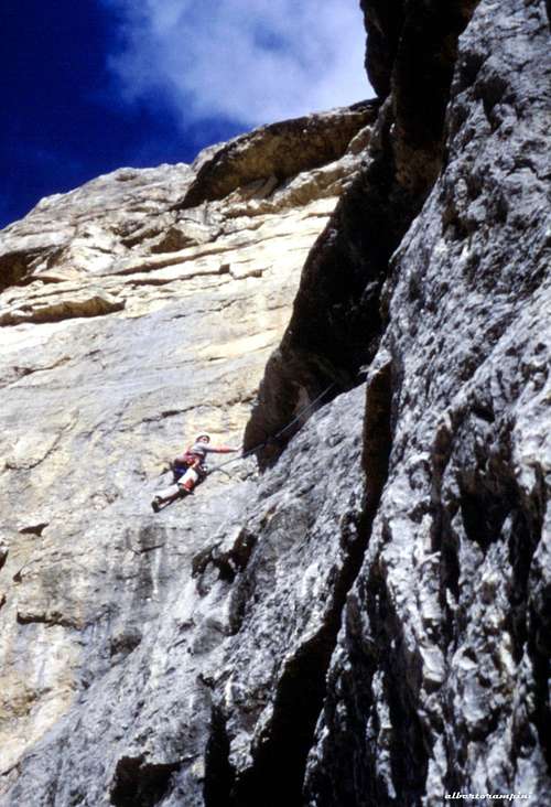
On Diedro Mayerl
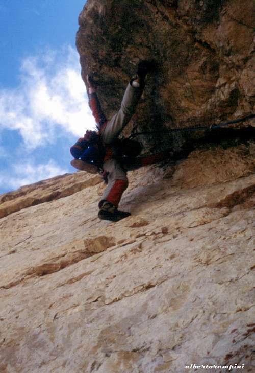
Overhang on Mayerl
West Face routes overview from left to right - UIAA scale
There are not easy routes: all routes are hard and challenging and sometimes require very high skill !!!!
Piz dl' Ciaval m. 2907 - West Wall
- Giglio Biondo VII, 300 m.
- Piero Pfeiler VI, 300 m. - Bini and Co. 1978
- Chiodo d'argento ED, 500 m. - Paolo Leoni, Graziano Maffei 1984 - More info and topo: Chiodo d'Argento
- Via Livanos-Gabriel ED, VI 550 m. - Robert Gabriel- George Livanos 12-15/8/1953
Pilastro di Mezzo - West Wall
- Loss Lei, Heb Schun IX- - Helmut Gargitter, Renato Botte june 2003
- Mephisto VII- 300 m. - L. Rieser, R. Schistl 1979 More info: Angelo Elli
- Via Messner ED, VIII (VI+, A1) 500 m. - Reinhold and Günther Messner 6-7/8/1968 More info and beta on Planetmountain: Via Messner al Pilastro di Mezzo
- Menhir EX, XI-, 200 m. - Nicola Tondini, Ingo Irsara 10/26-7-2010 More info and beta on Planetmountain: Menhir
Piz dl' Pilato m. 2825 - West Wall
- Kofler-Gabloner TD+, VI, 600 - H. Kofler, S. Gabloner, H. vonHellrigl 9/8/1936
- Quo Vadis EX+, X- (IX obbl.) 470 m. - Nicola Tondini e IngoIrsara 2010 More info and beta here: Planetmountain
- Diedro Mayerl ED, VII-, or VI/A1+, 600 m. - Sepp Mayerl e M. Rohracher 2-3/9/1962 More info and beta here: Planetmountain
- Silberschrei EX, 330 m. - Hansjörg Auer & Thomas Schreiber, 2005. First free-climb: 05/07/2009 More info and topo: Planetmountain
- La Perla Preziosa EX+, IX+, 375 m. - Nicola Tondini, NicolaSartori e Michele Zandegiacomo 2006-2008 More info and topo: Planetmountain
- Diretta Grande Muro ED, VII or VI/A1 500 m. - Albert Precht e George Wenger 26/6/1984 More info and beta here: Planetmountain
- Grande Muro ED, VII- or VI/A1 500 m. - Reinhold Messner e Hans Frisch 1969 More info and beta here: Planetmountain
- Weg der Blumen ED, VI+ 400 m. - H. Mariacher, Luisa Jovane, E. Wurm 5/8/1979
- Kleine Mauer ED+, VII, 400 m. H. Mariacher, Luisa Jovane 2/9/1979
Climber on the route Grande Muro (Messner-Frisch 1969)
Piz dl' Zübr (Piz del Mastello) m. 2718
- Left dihedral (Frisch-Renzel) TD+, V+, VI, 300 m. - H. Frisch, K.Renzler, F. Palfrader, H. Tauber 4/8/1970 More info and topo: Oltre la Vetta
- Central dihedral (Corradini-Frisch) TD, 300 m. - H. Frisch - P.Corradini 21/7/1970
- Auf die Felsen ihr Affen VIII, 250 m. Christoph Hainz e KurtAstner 23/7/1994 More info: Christoph Hainz
Pergo dla Forcela (Pulpito della Forcella) m. 2658 m. 2718
- Steger (West dihedral) TD, 250 m. - H. Steger, E. Steger 24/9/1960
Sass dla Crusc Normal routes
- Ciaval Normal route from East (Rif. La Varella) The easiest route to get Piz dl'Ciaval or Monte Cavallo, the main summit of Sass dla Crusc, starts from Rifugio La Varella m. 2038 on the Eastern side.
September sunset over Sass dla Crusc
Summit crest and summit of Piz dl' Ciaval in the background
From the shelter follow the path n. 7, reaching the small lake Le Parom, after which, at a path-fork at about m. 2380, take on the right the path n. 12 crossing the Pices Fànes tableland and getting to Forcella dla Crusc m. 2625, a rocky notch located on the wonderful and panoramic summit crest. Turn to right and reach the Ciaval main summit walking along the summit ridge (45 min. from Forcella dla Crusc).
Another way to reach this beautiful summit starts from Pedràces m. 1330 in upper Val Badia. By walking - or by the Santa Croce chair-lift starting from Pedràces - reach the Ospizio Santa Croce m. 2046, a marvellous shelter located below the stunning West walls of Sass dla Crusc.
Santa Croce
Via Ferrata
From the shelter take the path n. 7, rising at first amongst the dwarf-pines, then on a scree and getting the bottom of the wall. Here an easy Via Ferrata starts rising to the Forcella dla Crusc m. 2625, a rocky notch located on the wonderful and panoramic summit crest (about 2 hours from Ospizio Santa Croce). Turn to leftand reach the Ciaval main summit walking along the summit ridge (45 min. from Forcella dla Crusc).
When to Climb
Best season starts from June till October
Climate
In the Dolomites sometimes the weather is very changeable, with frequent thunderstorms especially in the afternoon. To climb the challenging routes on the West wall an alpine start is recommended.
Red Tape
No particular restrictions in climbing and hiking; all the group is situated inside the "Northern Dolomites Area", one of the nine areas of the Dolomites admitted in the year 2009 in the list of UNESCO NATURAL SITES. The eastern side of Sass dla Crusc is located inside "Parco Naturale Fànes - Sennes -Braies".
More info about Dolomiti Unesco World Heritage here:
Children refers to the set of objects that logically fall under a given object. For example, the
Aconcagua mountain page is a child of the 'Aconcagua Group' and the 'Seven Summits.' The
Aconcagua mountain itself has many routes, photos, and trip reports as children.
Parents refers to a larger category under which an object falls. For example, theAconcagua mountain page has the 'Aconcagua Group' and the 'Seven Summits' asparents and is a parent itself to many routes, photos, and Trip Reports.

 26050 Hits
 92.59% Score
 39 Votes