
-
 26129 Hits
-
 82.48% Score
-
 15 Votes
|
|
Mountain/Rock |
|---|---|
|
|
47.56220°N / 14.63270°E |
|
|
Mountaineering, Trad Climbing, Scrambling |
|
|
Summer, Fall |
|
|
7772 ft / 2369 m |
|
|
What's New On This Page?
- Jan 15th, 2019: Design corrections.
- Aug 1st, 2005: Interactive Google map inserted.
Overview
Gesaeuse

Pajahoral - from the E

kiss istván - winter view
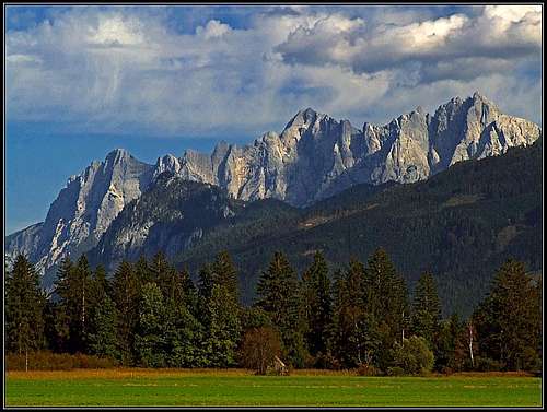
Hochtor is the highest peak in the Gesaeuse group. This is a beautiful limestone mountain group in north-east part of Alps. Actually it is a valley, where river Enns runs through a high alpine group referred also as Ennstal Alps. Gesaeuse is also a natural park and the whole area certainly deserves to be protected.
In Gesaeuse most of the highest summits are wild, sharp peaks with steep up to 1000 meters high walls. It is a perfect climbing area, where many good and important climbs were done in the past and of course it is also a hiking area. Many paths are marked, and it is also nice, that even though, some climbs are only marked, but not spoiled with artificial means, such as pegs, steel ropes etc.
Hochtor is the highest peak in a long mountain chain, going from the Grosser Oedstein (2335 m) on the southwest over Festkogel (2269 m), Hochtor (2369 m), Rosskuppe (2152 m) to Planspitze (2111 m) on the northeast. This chain has on its northwestern side a great, almost vertical wall, falling down in Haindlkar valley and on the slopes towards the main Gesaeuse valley. Driving alog the Enns river from Admont this scenery is a true landmark of Gesaeuse. Towards the southeast this group sends also steep, rocky walls, which are not so high and compact.
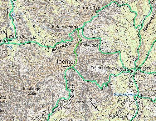
Hochtor itself is sending a long ridge towards the northeast to Planspitze, another ridge towards the southwest to Festkogel and two more short ridges towards the east and southeast. Over the northeastern ridge and the southeastern ridge marked approaches go.
Being the highest in its group Hochtor offers also a great panorama.
With his first ascents on the summits and by publishing his prototype of a modern guidebook, Gesäuse mountains were discovered and presented to the world by Wiener mountaineer Heinrich Heß. In 1877 he also first ascended Hochtor.
 |
 |
 |
 |
 Click to run this one online |
Getting There
The valley of river Enns can be reached by the Pyhrn highway (Linz-Graz) if you exit in Liezen and drive by the river Enns eastwards to Admont (where the famous Benediktine Abbey is) and further on. All starting poits in this valley (in the canyon) are low (on the altitude of about 600 m) as no road goes into the park. But there is one exception. At the railroad station Johnsbach a side road deters towards south and leads around the Hochtor group in the Johnsbach valley. But also this road ends on the altitude of only 851 m, at the Koelblwirt inn, where a popular south approach starts.
Through the Enns valley a railroad runs and Admont and Hieflau are also connected by bus.
Maps:
AV-Karte 1:25000, No. 16 - Ennstaler Alpen / Gesaeuse.
You can see a detailed map (1:50.000) on-line on:
Marked Routes Overview

On Dachlgrat

kiss istván - Rosskuppe N wall
1. From Hesshuette on the eastern side of the mountain over the southeastern ridge (T6).
2. From Hesshuette to Peternscharte and by the northeastern ridge to the top (T6).
3. From Haindlkarhuette to Peternscharte and by the northeastern ridge to the top (T4).
4. From Koelblwirt in Johnsbach over the south face (Schneeloch) (T4).
The ascent from Haindlkar over the NE ridge is one of the most beautiful easy climbs - a long, constant II. grade climb - still below the limit where you would need to be belayed.
 |
 |
 |
Red Tape
The whole area is a national parc, which means nothing for you - anyway you should not leave nowhere in nature any waste.
When To Climb
Summer and autumn month are best for the ascent. If you will not bring your own equipment, due to quite high altitude differences choose months when huts are open. In winter Hochtor can be ascended but you will need full winter equipment. The summit being so rocky, my judgement is, that it is not appropriate for a skiing descent.
Camping
Herbie: Sunset fireworks
For the Hochtor ascent there are three mountain huts, which can help you cut the altitude difference to the summit:
1. Hesshuette, 1699 m. Opened from mid/end May to mid/end October, 150 beds, tel.: 0043/663/039888.
2. Haindlkarhuette, 1121 m. Opened from mid May to mid October, tel.: 0043/3611/22115.
3. Koelblwirt Inn, 851 m. Tel.: 0043/3611/216.
Some tourist news you can find here, and some news about the natural park here.
 |
 |