
|
|
Mountain/Rock |
|---|---|
|
|
44.80860°N / 14.97180°E |
|
|
Hiking |
|
|
Spring, Summer, Fall, Winter |
|
|
5574 ft / 1699 m |
|
|
Google Earth
Since Google has blessed us with its magical Google Earth software you can visit any corner of the world from the chair parked in front of your computer. Thankfully Velebit is amazingly clear so you can discover its corners and see for yourself how it looks from the above and where are the places this page is dedicated to.
Each geographical point of interest described on this page has coordinates on the top of its section. You can use these coordinates with Google Earth’s fly to search engine. Just copy the coordinates (like it is written, with coma) and paste them into fly to tab and press enter. And, of course, enjoy the flight!
Intro
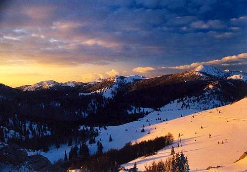
Zavizanska Kotlina (Zavizan basin) from Zavizan Hut (1594m). Right is Veliki Zavizan (1676m)
Even those that have nothing to do with mountaineering and Velebit have heard about Zavizan. In each weather update, it is always the first station read, which means coldest in Croatia. Many people make the first contact with Velebit on Zavizan. On Zavizan many people fall in love with Velebit for the rest of their lives. Why is that? Much is to blame on the road (macadam) which approaches it from Oltare village since 1961.
Zavizan is the highest and most beautiful place on Velebit, accessible by car. Since you don’t have to break a sweat to reach it people give it a try. Each time they get out of the car amazing scenery of rolling meadows, rocky peaks, romantic forest and blue Adriatic, strewn with white islands, unfolds before their eyes.
Each time a new love is born. Some will keep that memory and continue with their usual lives but many are changed forever. As they sit in the warm dining room of Zavizan hut and look over the meadows towards the blue sea while drinking a cup of most tasteful tea ever, which Vukusic family prepares from aromatic plants that grow around, most realize they missed much in life and return again and again. All thanks to Zavizan.
 |
 |
 |
 |
 |
Overview
This page is dedicated to beautiful Zavizan and Rajinci groups where Velebit exceeds 1600m for the first time from its beginning on Vratnik pass. This is hikers paradise in every sense with so many possible combinations. Trademarks of the area are soft grassy slopes and undulating plateaus, beautiful mixed forests of beech and spruce, rocky peaks which rise above them and magnificent sea views.
One could stay in Zavizan hut for days and explore around. It is placed 50m below the summit of Vucjak, on the edge of grassy slopes and is the highest lying object on Velebit. In a way the hut itself became a legend and one of the trademarks of the whole area. It is accessible by car (short branch from main macadam road) but due to large amounts of snow and up to 10-15m high drifts road is not cleaned. It is usable from the beginning of June till the first snow.
Those that really want to get to know Velebit and Zavizan will not come by car but will ascend from the coast via Klada route and observe how islands below diminish while mountain changes as its plant world adapts to various climates, from the Mediterranean to subalpine. Because of constantly open hut Zavizan is fantastic to visit in winter and is becoming more and more popular among tour skiers.
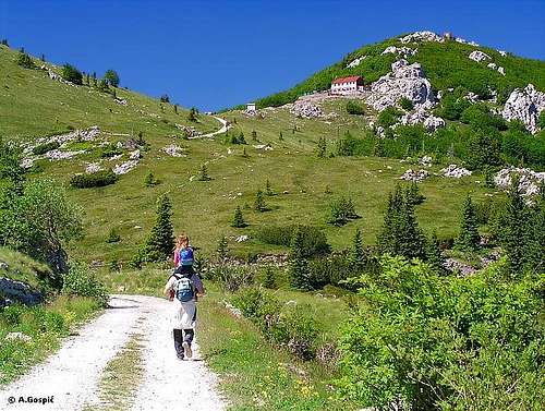
For many Zavizan is a place from which they’ll set to explore fascinating Rozanski Kukovi group. Zavizan is the starting point of the famous Premuziceva Staza path, that stretches around 50km through North and Mid Velebit. It was build by eng. Ante Premuzic between 1930-33. It takes visitors to the heart of Rozanski Kukovi. Since 1999 Zavizan became part of the newly founded North Velebit National Park. Just 15mins below the hut is Velebit Botanical Garden. Zavizan is also best base to visit Veliki Rajinac (1699m), highest peak of North Velebit, where amazing meadows and grassy plateaus exchange perfectly with deep and romantic beech and spruce forests. Anyway, each interesting or significant spot is described in its own section so let's not waste time and begin the Zavizan journey.
Note: Position of the page is that of Zavizan hut - 44°48'51.97"N, 14°58'31.15"E
 |
 |
 |
 |
 |
Zavizan Group
Zavizan group is situated in the mid part of N Velebit. It consists of many peaks above 1600 meters. The northern border of the group is 700-800m lower Krasanska Duliba valley and Oltari (1024m) road pass, which divides it from Senjsko Bilo group, with which Velebit begins. Peaks above Krasanska Duliba are Snjeznik (1610m), Pljesivica (1654m), Robinac (1587m) and Krecelj (1518m). They are mostly covered with beech forest.
Seaboard streak of peaks, visible along whole Velebit, begins here with Markov Kuk (1385m). Above/behind are peaks that form a wreath around Zavizanska Kotlina basin.
Zavizanska Kotlina is the heart of the Zavizan group. It is basin surrounded/closed by Zavizan group peaks. It consists of beautiful meadows but is mostly overgrown by beech, spruce and fir forest. Peaks that make wreath around Zavizanska Kotlina are:
~ Vucjak (1644m)
~ Zavizanska Kosa (1620m)
~ Balinovac (1601m)
~ Veliki Zavizan (1677m)
~ Debela Kosa or Gornji Zavizan (1637m)
~ Zavizanski Pivcevac (1676m)
~ Zalovacka Kosa (1642m)
Pass between Debela Kosa or Veliki Zavizan and Zavizanski Pivcevac consists of few meadows and is called Vukusic Katuniste. Here is the beginning of Lomska Duliba valley. Over that road leaves Zavizan group and descends into the valley.
South of Zavizan is wild and amazing Rozanski Kukovi group, strict preserve within the National Park.
Naturally attached to Zavizan on the SE is Rajinac group, which consists of Mali Rajinac (1699m), the highest peak of North Velebit, Veliki Rajinac (1667m) and Kitovac (1562m). Between these two streaks of peaks Jezera, around 1500m high undulating grassy plateau, is placed.
 |
 |
 |
 |
Vucjak (1644m)
44°48'57.47"N, 14°58'27.90"E
Vucjak (1644m) and Zavizan hut (1594m)
Vucjak is placed on the N edge of Zavizanska Kotlina basin. On the SW is the grassy cone of Zavizanska Kosa (1620m) while its eastern neighbor is Zalovacka Kosa (1642m). Pass between them is the highest point of Blatna Dolina forested valley which separates it from the streak of peaks above Krasanska Duliba. Over the pass Zavizan road enters Zavizan basin. The southern slope of Vucjak is partially grassy while from all other sides it is under beech, fir and spruce forest. Trees are stunted around the rocky summit because of wild winds, especially Bura.
Vucjak is inseparable from Zavizan hut, which is placed 10mins below its summit, and decorates its every shot. Rocky summit head is unfortunately polluted with small cube object that is used by radio amateurs. View from the summit is fantastic, especially towards the sea and Kvarner bay.
 |
 |
 |
Zavizanska Kosa (1620m)
44°48'42.65"N, 14°58'17.65"E
Zavizanska Kosa or just Kosa (kosa = hair) is nice grassy cone on the western edge of Zavizanska Kotlina basin, just opposite of Zavizan hut. It is placed between Vucjak (1644m) on the NE and Balinovac (1601m) on SW. Its grassy southern slopes descent into Modric Dolac. Summit is strewn with rock blocks and offers great view towards sea.
Zavizanska Kosa is probably the most frequently visited peak on Zavizan. Because its summit is just some 10mins from Zavizan hut it is an attractive goal even for those that don’t aspire to move away from their vehicles or the hut. Well, such visitors are really rare on Zavizan.
 |
 |
 |
Modric Dolac & Botanical Garden
44°48'26.15"N, 14°58'13.53"E
Modric Dolac (1500m) is a short grassy valley settled between the grassy peak of Zavizanska Kosa (1620m) on the N, steep and rocky Balinovac (1601m) on the W and forested Veliki Zavizan (1677m) on the S. East side is open towards Zavizanska kotlina. It flat except the very end, below Balinovac peak where is funnel-shaped depression. In 1966 in Modric Dolac and nearby area Velebit botanical garden has been established. The agitator of this project was Fran Kusan (1902-1972), professor on pharmaceutical university in Zagreb. The main purpose of the garden is scientific but also to present at least a part of the rich flora of Velebit. Modric dolac has its own microclimate because even in summer temperature can drop below 0°C during the night. Along the path, plants are marked with thin metal plates with names. On 30 hectares you can find local plants but also many that have been brought here from other parts of Velebit. Some of them are endemic and grow only on Velebit.
Modric Dolac is 15m from Zavizan hut. Visit to the Botanical garden is mostly combined with a climb on Veliki Zavizan.
 |
 |
 |
Balinovac (1601m)
44°48'27.80"N, 14°58'0.44"E
Balinovac (1601m) from Modric Dolac (1480m)
Balinovac is a nice rocky peak whose eastern side dominates above Modric Dolac and decorates its panorama. Towards it falls with some smooth cliffs but has steep rocky slopes all around. Balinovac is also one of the peaks that make a wreath around Zavizanska Kotlina basin. It is placed between Zavizanska Kosa (1620m) on NE (grassy saddle between) and Veliki Zavizan (1676m) on the SE (rocky ridge between). Western or seaboard side descend deep. It is made of torn rocks which are under beech and spruce forest. Around the peak, there are also some spruce and beech groves while on the rocky summit there is some dwarf pine.
Balinovac can be approached from Zavizan hut via Zavizanska Kosa or from Modric Dolac. Either way it takes around 30mins. This is a nice and short afternoon walk from Zavizan hut. Balinovac and Zavizanska Kosa are great sunset peaks from which it is visible all year. This also means that the view from the summit is beautiful towards the sea.
 |
 |
 |
Veliki Zavizan (1676m)
44°48'4.03"N, 14°58'19.01"E
Veliki Zavizan (1676m) and Modric Dolac (1480m) from Zavizanska Kosa (1620m)
Veliki Zavizan (velik = big) is the most eminent peak in the ring around Zavizan Kotlina and therefore is its trademark. It dominates on the SW edge of the basin and attracts most views from Zavizan hut. Veliki Zavizan is craggy but has more or less shape of a cone. Towards west (sea) it sends a narrow and steep ridge made of cliffs, called Medvjedja Greda.
From all other sides it is a bit less steep and under mixed beech, fir and spruce forest. Near the summit trees are stunted because of extreme winds. Summit is rocky, strewn with some dwarf pine and stunted fir. The first neighbor on the NW is Balinovac (1601m). They are connected with torn rocky ridge. In the northern foot is Modric Dolac and botanical garden. Behind Modric Dolac is the grassy cone of Zavizanska Kosa (1620m). On the east, across Vukusic Katuniste is Zavizanski Pivcevac. In terms of height but also shape they are like twins, 2 towers which guard the southern entrance to Zavizan.
Zavizan is approached by 2 paths. One leads from the edge of Modric Dolac via Cemerikovac meadow where it joins second from center of Modric Dolac. It is also possible to approach from Balinovac via rocky ridge that connects them. Veliki Zavizan is 1h from Zavizan hut. View from the summit is the best among the peaks of Zavizan group.
Whole N Velebit is on the palm of your hand and view towards sea and islands is fantastic. If you look carefully you can notice Adriatic road some 1500m below. It looks like a hairline with tiny microbes moving left and right, those would be cars.
 |
 |
 |
 |
 |
Zavizanski Pivcevac (1676m)
44°48'16.45"N, 14°59'29.26"E
On North Velebit there are 4 peaks with the same altitude, Zavizanski Pivcevac is a member of that exclusive club. It is one of the peaks that form a wreath around Zavizanska Kotlina basin, heart of Zavizan group. It has the same height as its western neighbor Veliki zavizan (1676m). Pass between them, called Vukusic Katuniste is the highest point of long Lomska Duliba valley which from here gradually descends towards SE. On the east is Jezera plateau, on SE Mali Rajinac (1699m), the highest peak of North Velebit.
Zavizanski Pivcevac itself is forested with mixed beech/spruce forest while the summit is rocky head. It has been approached by 2 marked paths. One leads from Jezera plateau. Second ascends from the road towards Lomska Duliba. It branches near Vukusic Katuniste. Close to road, by the path is Vukusic Snjeznica, a hole with eternal snow. Descent is possible but one must be careful. It is a nice afternoon trip from Zavizan hut to make a circle via these 2 paths. View from the summit is nice but not exciting as from Veliki Zavizan which faces sea or higher neighbor Mali Rajinac. It takes 1h to the summit from Zavizan hut, circle lasts 2h.
 |
 |
 |
 |
 |
Jezera
44°48'18.99"N, 15° 0'57.03"E (Crikvina junction at the center)
Jezera is the largest and most important high lying plateau of N Velebit (30 minutes from the hut). The average altitude of this 4km long undulating grassland is 1500m. Jezera means lakes and they got their name after small pools that exist there. Some of them remain till late summer at the bottom of funnel-shaped depressions. Near the only pool, which does not dry up, is the ruin of Crikvina and important junction of paths. Jezera are placed between the Krasno streak of peaks Zavizan and Mali Rajinac groups. It gradually descends from NW towards SE corner which is accessible by car from Apatisanska Duliba valley. Jezera are very romantic spot, especially in spring and autumn.
Over Jezera leads Krasno route towards Zavizan. It is also nice to climb Mali Rajinac partially using this route.
 |
 |
 |
 |
 |
Mali Rajinac (1699m)
44°47'36.15"N, 15° 0'46.10"E
Mali Rajinac is the highest peak of N Velebit. Although its name wouldn’t suggest because Mali means small Mali Rajinac is massive, and obviously high peak. It has the second largest mass, among the peaks of North Velebit, behind its brother Veliki Rajinac (1667m), which is on the SE. They are well separated by Suznica pass (1460m) and a valley Carski Dolci which contains a series of meadows. NE side descends almost 300m to Jezera, a large undulating plateau.
On the NW its first neighbor is Zavizanski Pivcevac (1676m). Between them is a larger area of forests and beautiful meadows. In the NW foot are Generalski Dolci meadows. Highest is SW slope which descends into Lomska Duliba valley, some 400m. On the opposite side of the valley is Rozanski Kukovi group. Mali Rajinac is steep from all sides. Its slopes are under beech/spruce forest with some fir. Summit is rocky with several large rocky blocks, just rising above stunted beech, fir and dwarf pine.
Paths from 3 directions lead towards it. Shortest approach from Zavizan hut branches on the NW edge of Jezera and heads straight towards Generalski Dolci (2h to summit). Second variation uses Krasno route till Crikvina junction in the middle of Jezera (2.30 to the summit from hut). The third path approaches from Lomska Duliba. This variation is used by those which go from Zavizan hut towards Lubenovac via Mali Rajinac or vice versa.
All 3 paths join in Generalski Dolci so from there one path leads to the summit. View from the top is wide, oriented on inner Velebit and especially beautiful towards Hajducki Kukovi and Rozanski Kukovi groups. Unfortunately Rozanski Kukovi mostly obscure sea. Finding a way to the summit of Mali Rajinac is rather difficult in winter because marks, even those high on trees, are usually under snow. View from the summit is wide and beautiful towards all sides and covers almost the whole continental side of Velebit massif. Just a small portion of the sea is visible behind Rozanski Kukovi.
 |
 |
 |
 |
 |
Veliki Rajinac (1667m)
44°46'57.81"N, 15° 1'33.58"E
Veliki Rajinac (1667m) is the lower brother of Mali Rajinac (1699m), the highest peak of North Velebit. Well, when judging from their names one might think it is the other way around. Veliki means big or large while Mali means small. Did those that named them had volume on their mind? Veliki Rajinac is certainly the largest peak of North Velebit and belong among highest. Its first neighbor is Mali Rajinac, on the NW. They are well separated by Suznica pass (1460m) and a valley Carski Dolci which contains series of meadows.
Veliki Rajinac, Mali Rajinac and Zavizanski Pivcevac (1676m), which is further on the NW, make NE side of long Lomska Duliba valley. SW side of Veliki Rajinac above Lomska Duliba valley or more precisely above Veliki Lom (1250m), a large 1km long meadow inside the valley, is its highest side, being over 400m high. Part of it is under beech/spruce forest but mostly it is a mix of grass and rocky, on places cliffs. The side is quite steep. On the opposite side of the valley is Hajducki Kukovi (1650m) group. Summit of Veliki Rajinac is also rocky and above the forest line.
All other sides are under beech/spruce forest. NE side descents some 250m into the Katalinac (bottom 1400m), a funnel-shaped depression with grassy bottom, which is placed in the forested area close to the southern edge of vast Jezera, a high undulating plateau. The first neighbor of Veliki Rajinac on the SE is Kitavac (1562m), a forested peak with a bare summit.
Recently Veliki Rajinac has been reached by marks from the hut in Apatisanska Duliba valley. This is quite a long forested approach which lasts almost 3h. The more attractive unmarked approach leads from Veliki Lom in Lomska Duliba, up the steep and bare SW side, which offers great views, especially towards Hajducki Kukovi. You have to aim for the rounded pass between the cliffs. Although from below it seam there could be some serious climbing up there passage is comfortable. Once on the pass large funnel-shaped depression opens in front of you. Go right around it and straight up towards the summit. View from the summit is very wide towards all sides. Whole Velebit is visible from here! Sea isn’t visible and the view is oriented upon inner Velebit and its continental side and Lika region. The approach from Lomska Duliba lasts around 1.30h.
 |
 |
 |
 |
 |
Krasanska duliba
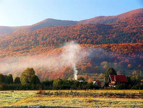
Morning in Krasanska Duliba valley
Krasanska duliba is 7km long oval valley, mostly forested with beech and conifer trees (fir & spruce). It is gradually ascending from SE towards NW where it ends, on Oltari (1024m) pass, which is the highest point. N side of the valley are slopes of Senjsko Bilo. It rises gradually with no eminent peaks. On the S are forested slopes of Zavizan group with Snjeznik (1610m), close to Oltari pass, Pljesevica (1653m), with a noticeable postal object on the summit, Krecelj (1518m) and Nadzak Bilo (1432m), already behind Krasno.
Krasno (800m)
44°49'28.80"N, 15° 2'59.25"E
Krasno (800m) is scattered and biggest surviving mountain village on Velebit. It is settled on the picturesque meadows in the Krasanska Duliba valley. The name of the village describes the scenery very well, krasno literally means beautiful. The village is surrounded with high and steep forested (mostly by beech) slopes from all sides. First written documents about Krasno date from 1219.
Today it has 1000 inhabitants, post office, store, school, forester’s office (founded in 1766), sawmill, parish office, bus stop, Rajinac mountaineering club and lately management of North Velebit National Park. Krasno is also well know for its cheese. Some houses are providing rooms. Apart from other Velebit villages, which are all dying it seams there is brighter future for Krasno, which is slowly developing into climatic resort with prospect in clean mountain tourism.
Winter is quite harsh with lot of snow. During clear winter nights temperature can drop as low as –30°C. Summer is mild with fresh nights. What can be better than swim on the coast during day and sleep well during the night on the fresh mountain air while it is still hot along the sea. Krasno is very good base for various trips on North Velebit. Here are few important road distances:
To Otocac (in Lika) – 21km
To Sveti Juraj (on the coast) – 24km
To Stirovaca (on Velebit) – 27km
To Zavizan (on Velebit) – 22km
 |
 |
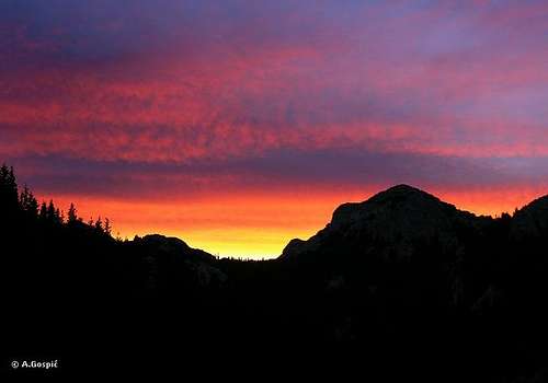
Zavizan Sunsets
Velebit is a mountain of sunsets and Zavizan is one of those rare places where you can enjoy it from the comfort of the warm hut, at least in cold part of the year when the sun sets on the west. Sunset is even better from surrounding peaks. All of them are close enough to the hut that you don’t have to worry dark will catch you on the return.
 |
 |
 |
 |
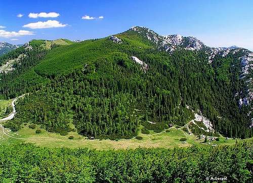
Zavizan Views
Views from the hut and whole group are fantastic towards North Velebit and especially towards the sea, Kvarner bay area and its islands. Italy, which is some 200km away on the opposite side of the Adriatic Sea, is visible on clear days, especially at sunset. Once I even saw the Alps in Italy which are somewhere behind Lago di Garda (around 300km away). When the night falls thousands of lights light up along the coasts and on the islands. Here is a more detailed description of the view.
N: beyond Senjsko Bilo, the first group of North and Velebit in general, is a large undulating area of Velika Kapela and Gorski Kotar mountainous region. Most easily recognizable there are Bjelolasica (1534m) and Klek (1181m).
E: Velebit gradually descends towards Lika region. Behind it are Mala Kapela and further back north part of Licka Pljesivica mountain with recognizable Gola Pljesivica (1646m) peak.
SE: in the distance, behind the peaks of North Velebit, most of South Velebit is visible including the highest peaks of Velebit which particularly stick.
S: many peaks of North Velebit including Hajducki Kukovi and Rozanski Kukovi groups.
SW: sea with Rab (410m) and Losinj (589m) islands.
W: sea with Rab (410m), Goli Otok (227m), Grgur (225m), Prvic (354m), Cres (650m) and other smaller islands.
NW: view is also dominated by sea or Kvarner bay. Largest Adriatic island Krk (568m) fills most of it. Left of Krk is north part of long Cres (650m) island. Behind them is Istra peninsula with Ucka (1401m) mountain. On clear days Julian Alps in Slovenia are visible, lead by Triglav (2864m).
 |
 |
 |
 |
Routes Overview
ZAVIZAN HUT APPROACHES
~ Gornja Klada – Zavizan: 5h, 1250m altitude gain (see here)
~ Krasno – Zavizan: 3.30h, 900m altitude gain + 100m altitude loss (see here)
~ Sveti Juraj – Oltari – Zavizan: 6h, 1700m altitude gain + 100m altitude loss (see here)
~ Oltari – Zavizan: 2.45h 700m altitude gain (see here)
FROM ZAVIZAN HUT
~ Vucjak (1644m): 5-10min
~ Zavizanska Kosa (1620m): 10min
~ Modrić Dolac, Botanical garden (1480m): 15min
~ Balinovac (1601m) via Zavizanska Kosa: 45min
~ Balinovac (1601m) via Modric Dolac: 40min
~ Veliki Zavizan (1676m): 1h
~ Zavizanski Pivcevac (1676m): 1.20h
~ Mali Rajinac (1699m): 2.30h
~ Gromovaca, Rozanski Kukovi (1676m): 2:15h (see here)
~ Rossijevo Skloniste refuge, Rozanski Kukovi (1580m): 2:30h, with Gromovaca 3h (see here)
~ Veliki Alan pass (1375m): 6h (see here + here)
~ Golubic, Hajducki Kukovi (1650m): 4.45h
~ Lubenovac (1280m) via Lomska Duliba and Lubenovacka Vrata: 5h
~ Lubenovac (1280m) via Rossijevo Skloniste: 4.45h (see here + here)
~ Veliki Kozjak (1629m): 6.30h (see here + here + here)
Hike Advice
Best short afternoon combination is to do a Zavizanska Kosa (1620m) – Balinovac (1601m) – Veliki Zavizan (1676m) – Botanical Garden – hut circle which lasts around 2-3h.
Mali Rajinac (1699m) can also be done as half-day trip from the hut. On the way towards it you can go over Jezera plateau and use direct route for return.
Most people that visit Zavizan don’t miss to combine it with Rozanski Kukovi. You can do it in so many ways, depending what you want to see and how good is your shape. Here is one great 3-day combination (2 days if you come to Zavizan by car) where you get see the most beautiful parts of North Velebit. On the 1st day reach Zavizan hut. In the afternoon do Veliki Zavizan circle mentioned above. On the 2nd day climb Mali Rajinac (1699m) via Jezera. Descent to Lomska Duliba and continue towards Lubenovac where is Lubenovac hut.
From Lubenovacka Vrata pass you have the option to climb Golubic (1650m) and Kuk (1649m), two highest peaks of Hajducki Kukovi and then descent to Lubenovac where you’ll sleep over. You can skip Hajducki Kukovi and head straight for the hut. Leave things there and climb Veliki Kozjak (1629m) instead. On the 3rd day head towards Krajacev Kuk (1659m) at the southern edge of Rozanski Kukovi. Leave things on the junction. After returning from the summit continue towards Premuziceva Staza path and Rossijevo Skloniste refuge. Leave things there and do Vratarski Kuk (1676m) circle. Pick up things and return to Zavizan. 3rd-day routes are described on Rozanski Kukovi page.
 |
 |
Getting There
3 different routes lead towards Zavizan hut. How to reach trailhead of each one is described with each route. Center of the region is Senj town below Velebit.
By Plane
From Zagreb you have to take a bus. Find more info about flights on official site of Croatia Airlines.
By Bus
If you are coming by bus from Zagreb you can look for time table towards Senj on the pages of Zagreb bus station.
From Senj you have to wait either local bus towards Krasno (early morning and mid day). Get down on Oltari pass, from here is 2.45h to Zavizan. Or from Senj take any bus towards south and get off in Gornja Klada, starting point to climb Zavizan from the coast (5h).
By Car
There are 3 main directions to come to this area, from Rijeka, Zagreb or Zadar. Starting point of Zavizan road is Sveti Juraj, on the coast, 10km south of Senj.
From Rijeka:
This route is suitable if you are coming from western Europe, via Trieste (Italy).
Trieste - Rijeka 70 km
Rijeka – Senj – Sveti Juraj - Zavizan 118 km
From Zagreb:
This road is suitable if you are coming from eastern or central Europe via Ljubljana (Slovenia), Maribor (Slovenia) or Budapest (Hungary).
Ljubljana - Zagreb 138 km, Maribor - Zagreb 113 km, Budapest - Zagreb 347 km
Zagreb – Karlovac – Zuta Lokva - Senj – Sveti Juraj - Zavizan 226 km
Zagreb – Karlovac – Zuta Lokva – Otocac – Krasno – Zavizan 216 km
From Zadar:
Zadar – Sveti Juraj – Zavizan 179 km
Look for current road conditions in Croatia on the page of Croatian Automobile Club (HAK)
 |
 |
 |
Maps
 |
 |
 |
When To Climb
Find out more about Velebit climate on Velebit main page.
Winter: Zavizan is one of the most popular spots on Velebit, not accessible by car, among those which love winter. The closest approach leads from Oltari pass and doesn’t last less than 3h (2.45 when there is no snow) but it can be much longer, depending on conditions. The good thing in winter is that Zavizan approaches mostly lead through the forest which provides some protection from Bura wind, most dangerous weather factor. But if Bura is above strong grade don’t go because blizzard and bad visibility are associated with it.
Trouble comes when you exit the forest below the hut. If Bura blows above 100kmh, which is in most cases, it is impossible to walk there. Some people got lost and froze to death. In the case you are caught by Bura it is best to use the road (under deep snow) because it is better protected. Crampons are necessary, mostly not for sections which lead through forest, but for open spaces where snow is usually hard-packed. You’ll also need it for any peak ascent. Snowshoes are good for forest sections where snow can be soft.
Spring: Till mid-June, because of slow-melting drifts, Zavizan road is not usable, at least not till very Zavizan. This mostly depends on winter and accumulated snow. If you aiming to shot amazing fresh greenery then visit Zavizan between May 20th and June 10th. Flowers mostly bloom in June. There is a huge time difference when trees turn green on Velebit. By the coast trees put out leaves around April 20th, at the beginning of May green is up to 800m, while forest at 1500m turns green in the last third of May. So it takes around 40 days from 0 to 1500 m.
Summer: lasts from mid-June till September. Weather is generally very good, a lot of clear, warm or even hot days. In July and August, there is not much of daily cloud development while in June the weather is more unstable, with frequent afternoon storms. If you are starting from the sea level do it as early as possible. Highest temperatures on Zavizan rarely get above 23°C in July and August. Generally, it is around 20°C, speaking of maximum daily temperature. The maximum measured was 29°C. Bura blows year-round but in summer rarely exceeds 100kmh.
Autumn: in the last third of September begins the color show. On Zavizan you’ll find naked trees after the first third of October. Days are already chilly in October but very. From my, over a decade long, observations there is more beautiful weather in October than in September. Peak autumn colors on Zavizan can be found between September 25th and October 5th. The first seasonal snow can fall at the beginning of September but won’t remain long on the ground.
 |
 |
 |
 |
Mountain Conditions
Conditions on Zavizan are very well known thanks to Zavizan meteo station, which is observing weather since 1953. On WeatherOnline & DHMZ (Croatian Meteorological and Hydrological Association) sites you can find current data for Zavizan and on WeatherOnline even forecast.
Here are the links where you can find out about the current weather on Velebit (Zavizan) and forecast for Croatia:
WeatherOnline:
WeatherOnline home page
Croatia at WeatherOnline,
Zavizan at WeatherOnline
Croatian Meteorological and Hydrological Association (DHMZ):
DHMZ home page
DHMZ Forecast page
DHMZ 7 Day Forecast for Croatian cities and places World wide
Current Weather Conditions in Croatia including Zavizan which reports weather between 04-14h & 19-21h. In summer it is 1h+.
Snow Depth's in Croatia
 |
 |
Objects
Zavizan hut (1594m) is open year-round. The weather technician is also the manager of the hut. That job belongs to, now legendary, Vukusic family whose 3 generations are now observing weather on Zavizan. Hut itself has electricity, water, phone (GSM signal also) and 28 beds. The kitchen is at disposal to prepare your own food. Today hut stands on foundations of old Krajaceva Kuca hut which was built by Croatian Mountaineering Association and opened on August 15th 1927.
It was named after dr.Ivan Krajac, one of the pioneer explorers of Velebit and those days president of the association. During the second world war, it was destroyed. In 1952 association build a new hut and opened it on July 27th, 1953. In 1965 it was renewed and enlarged. Zavizan hut is very popular year-round, especially in summer season when is very crowded and has a small capacity. It can be crowded in winter too. It desperately needs new enlargement. The phone number is +385 53 8910089. I think no one of Vukusic’s speaks English so this might be a problem :-)
 |
 |
Camping & Accommodation
Zavizan is inside North Velebit National park so camping is forbidden. There are dozens of camps on the coast, just below the mountain. Find more info on these links:
Adriatica.net, accommodation on Croatian coast
Senj town page
Hotel Ablana, Jablanac
Marijana apartments, Stinica
Otocac town in Lika region (behind Velebit), accommodation list
Lika-Senj county, various info about nature, places, accommodations…
Red Tape
Zavizan and the rest of the group are in North Velebit National Park. The entrance fee is 30 kuna (4 Euro). By coming on foot you avoid road entrances. In that case you are required to by a ticket in Zavizan hut.
Other Velebit pages on SummitPost
~ Velebit massif, main page, general info
~ Rozanski Kukovi group, North Velebit (Gromovaca (1676m) & Vratarski Kuk (1676m) highest peaks on the page)
~ Alancic / Rozanski Vrh / Seravski Vrh, North Velebit (Goli Vrh (1670m) highest peak on the page)
~ Veliki Kozjak (1629m), North Velebit
~ Satorina (1624m), Mid Velebit (including whole area between it and Alan pass)
~ Stap area, South Velebit, (Debeli Kuk (1269m) highest peak on the page)
~ Visocica (1619m), South Velebit
~ Bojin Kuk (1110m), South Velebit
~ Viserujna (1632m) & Rujno, South Velebit
~ Paklenica area, South Velebit
~ Vaganski vrh (1757m), South Velebit (highest peak of Velebit)
~ Liburnija (1710m), South Velebit
~ Sveto Brdo (1751m), South Velebit
~ Tulove Grede (1120m), SE Velebit
~ Crnopac (1404m), SE Velebit
Note: Text on this and pages above is copyrighted and cannot be used in any kind of publications.