
-
 52959 Hits
-
 91.14% Score
-
 34 Votes
|
|
Mountain/Rock |
|---|---|
|
|
47.48917°N / 120.80262°W |
|
|
Download GPX » View Route on Map |
|
|
Hiking, Mountaineering, Scrambling, Skiing |
|
|
Spring, Summer, Fall |
|
|
8520 ft / 2597 m |
|
|
Overview
Special Thanks to Dean who originally posted the information on this page.
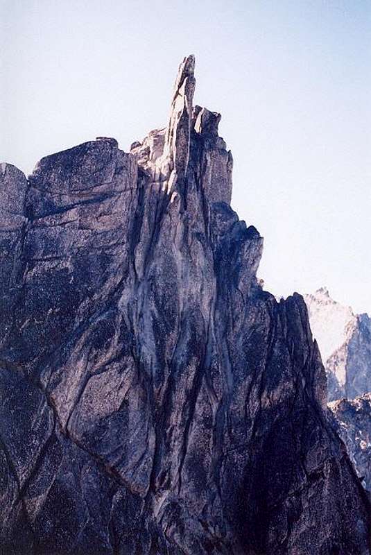
Enchantment Peak's SW summit
Like Cannon Mountain, just a little north of Enchantment Peak, this is not a peak that dominates any skyline or draws people's attention to it. Enchantment Peak is a high point in the Enchantment Lakes area that is distinguished by the fact that it is the 52nd highest point of land in the state of Washington. There are actually two summits of Enchantment peak, a NE one and a SW one.
The NE one is pretty much an easy scramble from Prusik Pass. However, the SW summit is not so easy and you may want to call it quits without going over to that summit. It is a bit of an undertaking but be forewarned, it isn't a walk in the park (read the next paragraph). Most are content to get to the top of the northeastern summit and call it good. Your call.
One thing that is worthwhile about attaining this summit, the view. Great views down on the Enchantment lakes below with Prusik Peak to the east, Cannon mountain nearby to the north and McClellan Peak, Little Annapurna, Dragontail and the upper enchantment plateau all laid out to absorb and enjoy.
The map calls this area the Enchantment Peaks for a reason, there are two summit areas. The NE summit and the SW summit are about a half-mile apart and it appears that the SW summit is of equal height but may be actually a bit higher. The map actually gives it one more contour line than the NE summit. The SW summit appears to be a two-foot wide needle about 25 feet tall.
In Peggy Goldman's book she says it is not a scramble but I wouldn't go by that. (Paul Klenke might be the best person to ask for more information on the SW summit) A rope may be a necessity as well as some protection. There is a route along the south side of the SW summit which gives access to the top. It begins where the western portion of the summit block meets talus slopes. It is Class 4 for a short section just beneath the top but should only be done by those who have the skill and expertise.
Getting There
From Seattle there are two routes you could take. First, you can get on I-90 and head east over Snoqualmie Pass to Cle Elum, taking the exit to Wenatchee & Blewett Pass via 970 and then US highway 97. Highway 97 takes you over Blewett pass to a junction with U.S. 2. Turn left towards Leavenworth. Go through Leavenworth (you pass the Leavenworth ranger station on this road) until you come to the last road before you start to enter Tumwater canyon and turn left on Icicle road, going 4 miles until you pass the Snow Creek Trailhead parking area on the left. Should you decide to go in via the Snow Creek trail, the most common route into the Enchantments, go no further. If you are going to use the Aasgard route via Colchuck Lake and the Stuart Lake TH, continue on past this parking area until you come to a turn off for Bridge Creek campground (left turn only) and FS road #7601, crossing a bridge over the Icicle River and continue onward almost 4 miles until the road ends at the Stuart Lake / Colchuck trailhead parking area. Northwest Forest Service pass required.
The second way to get to the same trailheads as mentioned above from Seattle or Everett area is to take US 2 over Steven's Pass to Leavenworth. When you come out of the canyon, turn right on the Icicle Creek road and drive as before.
Red Tape
Oh yes, RED TAPE runs rampant in this area of the Alpine Lakes Wilderness. With the proximity to major metropolitan areas of Seattle, Everett and all of the Puget Sound megapolis, there is a need to control the number of visitors to this very fragile area.
First, you need a NW Forests pass to park at the trailheads. You can purchase one at the Ranger Station in Leavenworth or at either one of the sporting goods stores. REI stores in Seattle or just about any outdoor sporting good stores elsewhere sell these passes. It is $5 a day or $30 per year. The Enchantment core area is a whole different kind of problem as you need a special permit to camp overnight in the Enchantment core area. Also, be certain to make sure your car doesn't appear to have anything valuable visible as break-ins have occurred at this trailhead. Day permits are available at both trailheads if you don't plan to camp out and these permits are free. To do this in one day, however, is a really difficult way to enjoy this area.
Obtain permits at the Leavenworth Ranger Station
600 Sherbourne Leavenworth, WA 98826 (509) 548-6977
For much of the needed information, click on Leavenworth Ranger station above (underlined)
When To Climb
May to late October depending on the winter snowfall. The prime time for doing Enchantment Peak is July through October. October is particularly special since if you time it right, you can be there during the golden week of the Lyall Larch. This is not a peak to be on or near if an electrical storm is approaching. There is no place to seek cover.
If you haven't seen Jeff Howbert's excellent resource of the Back Court 100 you should check it out. Enchantment Peak(s) comes in at #6
Camping
If you should be one who doesn't get an overnight Enchantment area permit and want to do it all in one day, then car camping is available at 8 mile campground on the way up the Icicle Creek road as well as Bridge Creek campground located on the turnoff on FS road 7601, just prior to crossing the bridge. You can camp at Nada Lake, Snow Lakes and the other lakes in the Enchantment area and campsites are plentiful near Shields Lake (as are the mosquitoes. Enchantment permits required of course to camp in the area (see red tape). Plan ahead and try and get a permit through the mail. See Leavenworth Ranger station info.
Enchantment Area Information
When the Wilderness Act of 1968 created the Alpine Lakes Wilderness area, an area right next door practically to Seattle and its growing suburbs, the Mt. Stuart / Enchantment Area was included. To me, that was super important as I've been an avid partaker of this area since 1971, when I first discovered the Enchantments and adopted them as my own. So for over 30 years, I've been going in and out of this area and its beauty never ceases to amaze me, on every single trip. Now, having said that, the Enchantment area is blessed with 6 of the 100 highest Peaks in the state of Washington. Enchantment peak as mentioned before isn't anything special, but it is a high point.
I printed this in my McClellan Peak page (the following) but it is a good summary of the peaks and the heights.
From the Seattle Mountaineers list of Washington's 100 highest peaks, here are the ones in the Enchantment area. #26 - Dragontail Peak 8840 ft Excellent page
#33 - Colchuck Peak 8705 ft Excellent page
#38 - Cannon Mtn. 8638 ft
#52 - Enchantment pk 8520 ft
#70 - Little Annapurna 8440 ft
#88 - McClellan Peak 8364 ft
If you want to do some rock climbing, be sure to check on the Prusik Peak page (click on it in the overview section) Recently
Prusik Peak was featured in Rock and Ice magazine. Back inside cover pic is super as it was taken during Larch season.
More information on the Enchantment area is being placed at Trip Reports at my McClellan Peak page. Just click on Trip Reports to get taken there.
Trails and other route information
If coming in via Aasgard Pass, you can approach Enchantment Peak directly by scrambling cross country to reach the peak. Use your topographic map and study the cover photo on this page to determine line of travel. I've only been up the Prusik Pass route so I can't offer any advice on going direct from the Upper enchantments but it seems very straightforward. Maybe someone will file a summit log report with a description for us.
The most common route is going up the Snow Creek trail as described on my McClellan Peak page. You go past Leprechaun Lake, go on to Rune lake and go right around the lake until you reach the very obvious and signed Prusik Pass branch trail. From this fork in the trail you gain about 400 feet to the pass and suddenly you have a great view in its own right of Shield's Lake to the north, Prusik Peak to the east and one of the most beautiful scenes in the whole enchantments, looking back towards Little Annapurna, Talisman and Rune Lakes.
If you climb up to the right of the pass about 100 feet, you'll find another even better viewing place as more of the Enchantments unfold below you and a great view of the west ridge of Prusik Peak, often occupied with several climbing parties. But our goal here is to get to Enchantment peak. Go west from Prusik Pass and work your way upward, ever upward. (see photo) No difficulty although occasional use of hands is necessary and some class 2 scrambling. I can't remember any places that had any exposure, all I can remember is the views. The higher you go, the grander the views get. I shot so many pics that I actually ran out of film before I got onto the summit but I'll never forget the mental pics I took that day. That is what makes Enchantment Peak so enchanting, it may be the premier view spot in the Enchantments.
Goldman in her book mentions that the southwest summit is not a scramble. To attain it, you need to keep to the east of the crest to avoid obstacles. Her description is minimal and I flat out don't remember any detail about the southwest summit. Maybe a reader can add some additional information or make a route description for us on the southwest summit.
If you have information about this mountain that doesn't pertain to any of the other sections, please add it here. Enjoy an Enchantment visit.
 |
 |
 |
 |
 |
Rock and Ice Magazine Article
In the November issue of Rock and Ice magazine (#119), just inside the back cover was a picture of Prusik Peak. Some route descriptions were included but most stunning was the picture of Prusik. In the recent issue, January's #121), a reader wrote in to voice objection to the fact that the magazine had focused on the Enchantment area (meaning Prusik in this case) and was concerned about the fact that not enough was said about the permit system and the heavy impact that this area is subject to. Overuse was the concern, too many people.
Here's my 2 cents on that. The majority of people now coming into this area (wasn't always this way) understand the LNT ethic. You have to earn your way up to the Enchantments, you pay for it one upward step at a time. You are entitled but do be legal and get the required permit(s) and follow the rules of this fragile high country. It is there for all of us to enjoy so we need to take proper care of it. Here is a pic I took of Prusik that is from the same spot as the Rock and Ice photo.
Updated information on access
For more information on current conditions of roads and trails please contact the Leavenworth Ranger Station at: 509-548-6977.
Local Weather Report
Click HERE for Leavenworth weather

External Links
Recent Trip Reports & pics from NWHikers:
August 2007 trip can be found HERE
Check out this one and. this one
Disclaimer
Hiking or climbing in a mountain environment has many risks. Any who choose to participate in such activities must assume the responsibility for their own actions and safety. Any information provided here cannot substitute for your own sound judgment and decision making skills. For example, hiking into an electrical storm or during an electrical storm is reckless and dangerous. It is not my intent to describe every risk (weather, rockfall, animals, accidents, etc) that you may encounter on visiting this area but the author of this page is not responsible for your safety. You need to be prepared for the unexpected and proceed accordingly. All risks are assumed by the participant(s).
Having said that, I wish you a great trip into this magical area but exercise care and caution to make your visit a safe one.
Redwic - Jun 13, 2011 10:15 am - Hasn't voted
ClarificationI just want to clarify one of the statements currently made on this page. There are actually two distinct summit areas, one NE and one SW, but the SW summit area has *three* distinct summit contours with the southwest-most point being the obvious highest point of those three. Don't bother with the middle and northeast points of the southern summit area. The northeast-most summit (scramble) of the mountain is obviously 30'-40' higher than any of those middle points between the northeast-most and southwest-most summits. I wanted to mention this because we found multiple maps showing all three southwest contours as being higher than the northeast-most contour, and that certainly is not true. Don't bother with any of those middle contours.
Dean - Jun 14, 2011 1:11 pm - Voted 10/10
Re: ClarificationYou guys had a nice trip. A dream come true for many would be to do what you all accomplished, a true slam. McClellan and Cannon would make a six effort and cover the Enchantments but that would be alot to try and do on one trip. I love that Enchantment area.
rbuzby - Jul 25, 2017 9:42 am - Hasn't voted
Attribution" To me, that was super important as I've been an avid partaker of this area since 1971, when I first discovered the Enchantments and adopted them as my own. So for over 30 years, I've been going in and out of this area and its beauty never ceases to amaze me, on every single trip." Your bio says you are 24 years old. If you post a quote from someone else, you should attribute it to them.