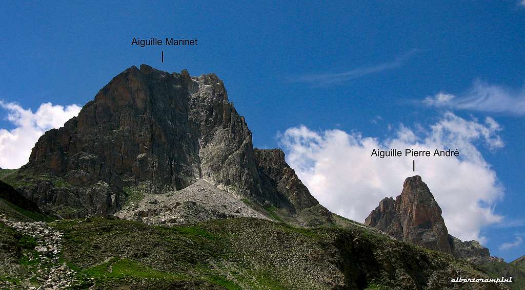
Aiguille Pierre Andrè is a stunning pyramidal peak belonging to the Chambeyron range, Ubaye valley. Due to the harmonious shape and the beauty of the rock, it is considered as the Aiguille Dibona of the Ubaye. Although not so superb and flashy, it's a beautiful slender spire, with a South-South-East wall built with an excellent quartzite, showing a strong orange color. A beautiful needle in a wild context with great equipped climbs, especially in its South-East face.
The Chambeyron
Four routes are located on the spire, amongst those the most frequently climbed is Marmottes Givrées, a magnificent steady route on extra quality orange quartzite leading directly on the summit. On Aiguille Pierre Andrè the quartzite is very rich in handholds and this fact make it possible to climb on extremely steep walls without exceeding the grades 6a+/6b (5.12b).
Aiguille Pierre AndréAiguille Pierre André
The Normal route rises along the shortest West wall. There are no weak sides and to reach the summit needs to climb, so every route, even the Normal one, involves the use of climbing gear.
Aiguille Pierre André and Aiguille Large de Mary annotated pano
Getting There
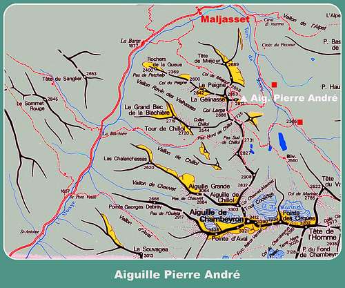
The starting point to climb on Aiguille Pierre Andrè is the hamlet of Maljasset. It can be reached:
From Durance Valley: Gap or Sisteron - Barcelonette - St-Paul/Ubaye - Maljasset From Durance Valley: Embrun or Briançon - Vars pass - St-Paul/Ubaye - Maljasset From Italy: Colle della Maddalena - St-Paul/Ubaye - Maljasset
Maljasset ancient church
The approach trail
Aiguille Pierre André
From the hamlet of Maljasset take the itinerary to Col Mary, starting with a dirty road through the larches, then becoming a steeper path. At the second grassy terrace there is a junction where you must leave the main trail to Col de Mary and take the right branch (signpost "11ème BCA"), a narrow path crossing a stream, then rising with several hairpins and leading below Pierre Andrè South face (2 hours from Maljasset).
Main routes
The main routes to climb the summit:
- Normal Route (West Face) 3b, 3 pitches, route equipped with some rings along the pitches and anchors at the belays - Short climb developing on the West wall of the spire. It is frequented above all to descent from the top of the spire.
Red quartzite on Marmottes GivrèGetting the stance on the route SSE
- Marmottes Givrées on Summitpost TD, French 6a+ max, UIAA VI+, YDS 5.10a, 200 m (6 pitches), route equipped with bolts - A beautiful and athletic climb not to be missed, perhaps the finest on the spire. It's more modern, more direct than the SSE, a little better equipped (spaced bolts in the easy) and more difficult. Some climbers have seen marmots work food inside their backpacks....
- La SSE (Honorat-Cerciello) UIAA V+, 180 m (7 pitches) - Classic route, the start is a few meters to the right of Marmottes Givrées
- Vieux boucs, new lookFrench 6b max, 200 m (7 pitches) - Another beautiful climbing route with a length more difficult than the rest (6b), which can be bypassed by a simpler section, making the route more homogeneous and accessible.
Marmottes Givrè second pitch
Descent route
Aiguille Pierre André - The summitRapping down Aiguille Pierre André
From the summit head to West to find the first fixed anchor. Abseil down with 3 abseils (25m + 20m + 15m)
Essential gear
There are no hiking trails that climb to the summit, so every route, even the Normal route, involves the use of climbing gear.
Red Tape
There are no particular restrictions in climbing and hiking. Cars in Maljasset village are not allowed. Leave them in the parking before entering the village.
Accomodation
There's an equipped camping open in summer in Saint Paul sur l'Ubaye. Otherwise in Maljasset you can stay in:
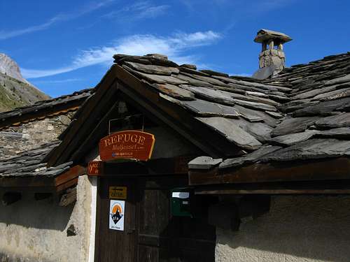
Altitude: 1905 m Commune: St-Paul/Ubaye IGN maps: 3538 et 3637 OT Access: D25 road, access by car Owner: Fédération Française des Clubs Alpins et de Montagne - FFCAM Guardian: Federica Perino Fontana Beds: 60 Phone: 04 92 31 55 42 / 07 68 86 01 11 Open: from February 1st to May 10th - from June 10th to November 3rd - from December 26th to January 3rd
- Gite d’etape “La Cure” - Maison d’hotes “La Posada” in Pont d’Estreche
When to climb
Maljasset ancient churchRuins of an ancient alpMarmottes Givreé
Children refers to the set of objects that logically fall under a given object. For example, the
Aconcagua mountain page is a child of the 'Aconcagua Group' and the 'Seven Summits.' The
Aconcagua mountain itself has many routes, photos, and trip reports as children.
Parents refers to a larger category under which an object falls. For example, theAconcagua mountain page has the 'Aconcagua Group' and the 'Seven Summits' asparents and is a parent itself to many routes, photos, and Trip Reports.


 13770 Hits
 88.34% Score
 28 Votes