

-
 88706 Hits
-
 89.95% Score
-
 31 Votes
|
|
Mountain/Rock |
|---|---|
|
|
48.04150°N / 121.3401°W |
|
|
Download GPX » View Route on Map |
|
|
Snohomish |
|
|
7835 ft / 2388 m |
|
|
Overview
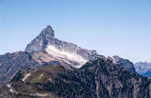 The South Face
Sloan Peak stands high above peaks of the Mountain Loop Highway. It's distinctive profile makes it visible across wide regions of the Cascades. The first ascent was made by Harry Bedal and Nels Skaar on July 30, 1921. Some say Sloan resembles a ship gliding across a snowy sea. It's nearest higher neighbor is Glacier Peak to the east.
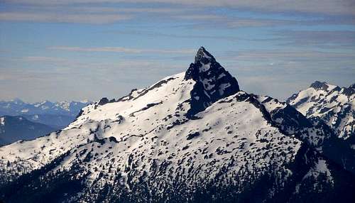 The North Face
The Corkscrew Route is considered the easiest way to climb the mountain. It starts with a trudge through a swamp to a ford of the Sauk River (can be dangerous). Then a long climb up to timberline, a crevassed glacier and rock scrambling to the summit.
It is a relatively popular non-volcanic climb, giving a taste of the mountaineering difficulties to be found further north.
 |
 |
 |
 |
 |
Route Map
Getting There
From Granite Falls take the Mountain Loop Highway to Barlow Pass (32 miles), then drive 7 miles to the North Fork Sauk River Road. Take this road 4.5 miles to a pullout (approx. 1900 feet). Follow flagging and trail for 1/2 mile to a crossing of the North Fork of the Sauk River. Be careful here in early season or late in the day.
 Route Finding Issues
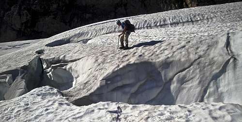
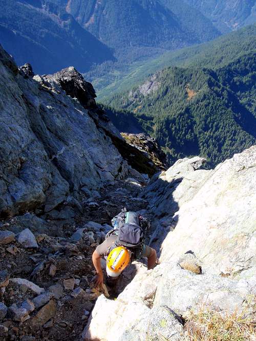
On the other side follow a gravel bar upstream several hundred feet, looking for a flagged trail into the forest. This trail gets more defined as it follows an old logging road (barely recognizable) up the hillside. Cross Couger Creek at 3100 feet, and climb in the deep, dark forest to a small open area at 4600 feet. It's easy to lose the trail here, but the idea is to climb to a rocky ridge paralleling the glacier. I like to scramble polished slabs to the highest accessible entry onto the glacier, a few hundred feet below the vertical North Face.
Another approach is from Bedal Creek, someone may have notes to add here.
 |
 |
 |
 |
 |
Red Tape
A Northwest Forest Pass is required to park at the trailhead ($5 per day, $30 annual). More information can be found at the Mt. Baker-Snoqaulmie National Forest web site. The mountain is in the Darrington Ranger District.
When To Climb
June to October. It may be difficult to drive near the trailhead outside of this season. In winter, expect a long ski trip to the trailhead, and the upper mountain may present avalanche danger, since the Corkscrew Route does much traversing on steep heather/rock slopes.
 |
 |
 |
Camping
You can camp anywhere you find a flat spot. Many people camp on the ridge paralleling the glacier. That would be a very scenic spot (but a long ways to hump the gear).
Mountain Conditions
You need good weather for Western Washington, check the state forecast. Don't bother without a stellar forecast, because if it is wet, the very brushy travel and ford will soak you, and the view is the best part about this climb.
 |
 |
 |
 |
 |
External Links
The Dirt Gully
Trip Reports
- Michael's report of the Corkscrew Route
- Phil's report of the very same trip! Different photos! Different impressions!
- Gordon's climb, and report of an accident which turned fatal eventually.
- Michael and Theron climb the west face.