
-
 147098 Hits
-
 94.77% Score
-
 58 Votes
|
|
Mountain/Rock |
|---|---|
|
|
28.56670°N / 83.83330°E |
|
|
26545 ft / 8091 m |
|
|
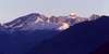
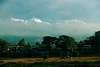
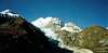
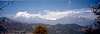
Overview
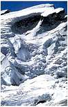
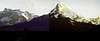
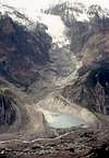
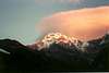
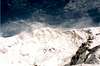
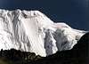
Annapurna is the 10th highest mountain in the world and was the first 8000m peak to be climbed. It was first summited in 1950 by Maurice Herzog and Louis Lachenal. It was not until 1970 that Annapurna was summited again. In the autumn of 1999 there were 120 expedition to Annapurna. 106 climbers reached the summit. 54 climbers never came back. As of the end of 2009, there had been 157 summit ascents of Annapurna I, and 60 climbing fatalities on the mountain. This fatality-to-summit ratio (38%) is the highest of any of the eight-thousanders. In particular, the ascent via the south face is considered, by some, the most difficult of all climbs.
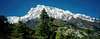
The Annapurna massif contains six major peaks over 7,200 m (23,620 ft):
Annapurna I 8,091 m (26,545 ft) Ranked 10th;
Annapurna II 7,937 m (26,040 ft)
Annapurna III 7,555 m (24,786 ft)
Annapurna IV 7,525 m (24,688 ft)
Gangapurna 7,455 m (24,457 ft)
Annapurna South 7,219 m (23,684 ft)
I am assuming you are more interested in trekking the Annapurna region , so most of this information will pertain to trekkers considering this trip. For an excellent accounting of one persons adventure doing the Annapurna circuit and tons of nice photographs see www.cs.dartmouth.edu/whites/nepal
 |
 |
 |
 |
 |
Getting There
Everything in Nepal starts from Kathmandu. A section of Kathmandu called Thamel tends to cater more to climbers and trekkers, and I would recommend staying there a couple days as you explore Kathmandu and make arrangements. You can have a tour agency there make arrangements to get you a guide and porters if you want . Frankly, if you are going to be trekking, unless you really travel with a lot of stuff, a guide may be all you need or would want. If you are good with map and compass you may not even need a guide. However, the guides are relatively inexpensive and are helpful plus you will have more opportunities to learn about the region. If you are going to be trekking you can readily book it all once you arrive in Kathmandu. There are numerous agencies there and and they are anxious to compete for your business. If you dont mind roughing it a little, and spending a day booking it all, this way is a lot cheaper than booking a trip in your home country through a more commercial agency. Plus it gives you far greater flexibility.
Gateway to the Annapurna region is the city of Pokhara. You can reach Pokhara by plane or bus from Kathmandu.
 |
 |
 |
 |
 |
Permits, Visa and Fees, Oh My
-Oh Yes! The general rules and regulations for expeditionary peaks are too lengthy to document here. To get all the red tape write directly to Ministry of Tourism, His Majesty's Government, Kathmandu, Nepal. Basically a permit must be obtained "with the recommendation of a reputed and recognized mountaineering institution in the appropriate country, or that embassy in the country of Nepal." Of course, there are the "usual royalties" for climbing an expeditionary peak.
You will also need a trekking permit for each region of Nepal you will be trekking. There is an "office" in Kathmandu where you can get your permit at Dilli Bazaar or you can also get your permit at the Pokhara airport. You will also need a visa.This can be obtained from the Nepali Embassy in your country. Regulations change from time to time so it is wise to check with the various trekking agencies in Nepal.
There are two permits required for the Annapurna circuit trek. The first is the ACAP permit (Annapurna Conservation Area Permit) the second is the TIMS permit (Trekking Information Management System). You get them both from the big, modern Nepalese Tourist Centre (shown as the ‘Tourist Information Centre’ in the Lonely Planet book maps). This "office" is closed on Saturdays. It is about a half hour walk from Thamel.ACAP needs 2 passport photos and costs about 2000 RS and must be paid for in local currency.
Information from http://www.timsnepal.com/index.php?option=com_content&view=article&id=10&Itemid=37 says
TOURIST VISA
Foreigner who intends to visit Nepal must hold valid passport or any travel document equivalent to passport issued by the government. for visiting a foreign country prior to apply for visa.
a) Entry: No foreigner is entitled to enter into and stay in Nepal without valid visa. Tourist entry visa can be obtained for the following duration from Nepalese Embassy or Consulate or other mission offices or immigration offices located on entry points in Nepal.
b) Chinese citizen are requested to apply in Nepalese Embassy or other Nepalese diplomatic missions as there is no provision of on arrival visa for them.
c) Visa Fee:
1. Fee required to obtain Tourist Visa from Nepalese diplomatic agencies and entry points:
a. US $ 25 or equivalent foreign currency for Tourist Visa with Multiple Entry for 15 days.
b. US $ 40 or equivalent foreign currency for Tourist Visa with Multiple Entry for 30 days.
c. US $ 100 or equivalent foreign currency for Tourist Visa with Multiple Entry for 100 days.
d. Regardless of the provision stated in 1(a) and 1(b), tourists with passport from South Asian Association for Regional Cooperation (SAARC) nations aren't required to pay visa fee for 30 days.
2. Fee to be levied for renewal or regularization of tourist visa
a. Nepalese currency equivalent to US $ 2 per day to renew the validity of tourist visa.
b. If multiple entry facility is required to be valid for the renewed period, additional US $ 20 along with fees prescribed in 2 (a) has to be paid.
c. Foreigner who have stayed here without renewing visa, need to pay Nepalese currency equivalent to US $ 3 per day along with the reqired extension fee.
d. Foreigners, who have already overstayed for more than 150 days without renewing tourist visa shall be levied the fees referred in clause 2(c) and a penalty of Rs 50,000 as per the Immigration Act.
e. Regardless of provision stated in 2(a), 15 days is counted as minimum extension period and visa fee is charged accordingly. For extension period more than 15 days, visa fee is charged as per the provision of 2(a).
Note:
- The tourist visa shall be granted for a period in maximum of 150 days in a visa year (Visa years means January to December).
- A tourist who has departed before the expiry of the period specified in the visa issued in a visa year shall not be allowed to use the visa by adding the remaining period to another visa year.
- However, foreigner visitors, who have entered the country towards the end of a visa year, can use the remainder of his visa period in another visa year.
TREKKING PERMIT
Trekkers planning to travel to controlled areas in Nepal opened for group trekking need to get Trekking Permit issued by the Department of Immigration under the Home Ministry. The government has opened following previously restricted trekking areas for group trekkers. Trekking permits will not be issued to individual trekkers in those trekking areas. The areas and required fees are as follows:
.N. Trekking Area Permit Fee
1 Dolpa District
a. Lower Dolpo Per week per person US$ 10 Or equivalent convertible foreign currency.
b. Upper Dolpo For the first 10 days per person US $500 and After 10 days per day per person Us$50
2 Taplejung District Per week per person US$ 10 Or equivalent convertible foreign currency.
3 Kanchanjunga Region (Areas of Olangchunggola,
Lelep, Papung and Yamphudin Village
Development Committee) Per week per person US$ 10 Or equivalent convertible foreign currency.
4 Upper Mustang For the first 10 days per person US $500 and After 10 days per day per person Us$50.
5 Gorkha District
a. Manasulu From September to November per week per person US$ 70 and After 7 days per day per person US$ 10.and From December to August per week per person US$ 50 and After 7 days per day per person US$ 7 /Or equivalent convertible foreign currency.
b. Chhekampar & Chumchet VDC (Sirdibas-Lokpa-Cumling-Chhekampar-Nile-Chhule Area) From September to November per person US$35 for first 8 days and from December to August per person US$25 for first 8 days or equivalent convertible foreign currency.
6 Gauri Shankar and Lamabagar in Dolakha district Per week per person US$ 10 Or equivalent convertible foreign currency.
7 Simikot and Yari in Humla district
Areas of Limi and Muchu village Development Committee, and area way to Tibet via Tangekhola of Darma Village Development committee.
For the first 7 days per person US$ 50 and After 7 days per day per person US$ 7 Or equivalent convertible foreign currency.
8 Thuman and Timure in Rasuwa district Per week per person US$ 10, Or equivalent convertible foreign currency.
9 Makalu Region in Sankhuwasabha district
Areas of Kimathanka, Chepuwa,Hatiya and
Pawakhola Village Development Committee.
For the first 4 weeks per week per person US$ 10 and After 4 weeks per week per person US$ 20, Or equivalent convertible foreign currency.
10 Everest Region in Solukhumbu district
All north-west area way from Thame to Nangpala of Namche Village Development Committee
For the first 4 weeks per week per person US$ 10 and After 4 weeks per week per person US$ 20, Or equivalent convertible foreign currency.
11 Manang District
Areas of Nar and Phu and northern parts of Tilicho VDC
From September to November per week per person US$ 90 and December to August per week per person US$ 75 Or equivalent convertible foreign currency.
12 Mugu District
Areas of Mugu, Dolpu, Pulu and Bhangri
For the first 7 days per person US $90 and After 7 days per day per person Us$15 Or equivalent convertible foreign currency
13 Bajhang District
Areas of Kanda, Saipal and Dhuli
For the first 7 days per person US $90 and After 7 days per day per person Us$15 Or equivalent convertible foreign currency.
14 Darchula District
Areas in Byas VDC
For the first 7 days per person US $90 and After 7 days per day per person Us$15 Or equivalent convertible foreign currency.
Notes:
a. To get a group trekking permit an application form with other relevant documents should be submitted through any registered trekking agency of Nepal.
b. Trekking fee can be paid in Nepalese currency. Notwithstanding anything written in above, the Indian citizens can pay in Nepalese currency equivalent to US Dollars.
 |
 |
 |
 |
 |
When To Climb
The usual trekking season in Nepal is from October to May. The rest of the year is the monson season and is not desirable for either trekking or expeditions. Besides the cold and rain, leeches are a problem during the monsoons. If you are going to be trekking to Annapurna, October and November are the best months.
 |
 |
 |
 |
 |
Camping and Tea Houses
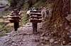
If you are on an expedition to climb Annapurna you will surely have more information than I can give you here from the leader of the expedition. But assuming you are more interested in trekking in the Annapurna circuit region, you can either arrange a trip from a tour agency or do it on your own. Personally, I prefer to do it with a buddy or two rather than the organized tour. This gives greatest flexibility, and reduces expenses considerably. Most of the trekking routes have "tea houses" where you can stay for a nominal amount each night. These are usually accomodations for a few people to a dormitory type situation. Reservations are not necessary and you basically stay in a private home/lodge. Just try to hike early to arrive in your next village early as it is first come first served. Breakfast is also included. I find this a lot easier than lugging a tent around. Also, the added benefit of meeting travelers from around the world and living with the local people is much more rewarding to me than being isolated in a tour group.
If you want assistance, you can hire a guide or a porter. If you do be sure to negotiate with them not only the fees, but when/how the fees will be paid, who decides where you will stay and other similar logistical situations.
.
 |
 |
 |
 |
 |
Important Ascents of Annapurna I
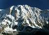
Annapurna I was the first 8,000-meter (26,200 ft) peak to be climbed. Maurice Herzog led the expedition reached the summit on 3 June 1950. However, this summit was not without drama. As Herzog and the french climber, Louis Lachenal began their descent Herzog tried to get something out of his backpack. Not securing his gloves, they fell and tumbled down the mountain face. At the time it was a loss of the use of his hands in the cold. At the end of the expedition it would mean amputation of fingers. Later, Lachenal fell into a crevasse and took 3 members of the team with him. Fortunately it was not too deep and the 4 were rescued the next day. Finally, on the descent to Camp 2 the team was caught in an avalanche. Herzog was roped to two Sherpas, and when they came to the bottom of the avalanche Herzog found himself swinging upside down in a couloir with a rope strangling him around the neck. Luckily he was rescued by other Sherpas.
The mountain was not summited again until 1970 when a British Expedition led by Henry Day made the summit. A few days later the peak was again summited by an expedition led by Chris Bonington. Don Whillans and Dougal Haston were on this expedition and were the first to summit via the south face.
Courtesy of jck : Very important ascent was the third one made by British expedition led by Christian Bonington in 1970.
They climbed left pillar of south wall and the summit was reached by Don Whillans and Dougal Haston.In that time it was incredible achievment.During one day,in very difficult terrain and strong wind Whillans and Haston climbed the top from the camp at 7350 without using oxygen.They proved that's possible to climb very difficult route on high altitude without using oxygen.Experiences from that expedition had significant meaning for next expeditions on other 8000m peaks' walls.
Since that time many new routes have been climbed.Worth mentioning are:second ascent of summit 8051(little bit east from main summit)made in 1981 by Maciej Berbeka and Boguslaw Probulski via right south pillar, Reinhold Messner's route from the north-west side(1985) and Kukuczka and Hajzer's route on east ridge of east summit of Annapurna(8010) on 13th of October 1988.
The American Women's Himalayan Expedition, a team led by Arlene Blum, became the first United States team to climb Annapurna I in 1978. The first summit team, comprising Vera Komarkova and Irene Miller and Sherpas Mingma Tsering and Chewang Ringjing, reached the summit on October 15, 1978. The first winter ascent of Annapurna I was on 3 February 1987 when two Polish climbers Jerzy Kukuczka and Artur Hajzer made the summit.
Annapurna I is one of the most fatal of all 8000 meter peaks. As of 2005, there have been only 103 successful summit attempts, and 56 lives have been lost on the mountain, many by avalanche. The famed Russian climber Anatoli Boukreev was killed by avalanche on Annapurna I in 1997 as were Christian Kuntner in 2005 and Iñaki Ochoa in 2008.
The first solo climb occurred in October 2007 on the south face by Slovenian climber Tomaž Humar.
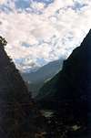
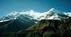
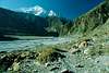
Trekking in Annapurna Region
The Annapurna Conservation Area is a well known trekking region.
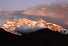
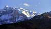
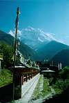
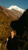
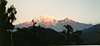
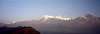
There are three major trekking routes in the Annapurna region: the Jomson Trek to Jomsom and Muktinath, the Annapurna Sanctuary route to Annapurna base camp; and the Annapurna Circuit, which circles the Annapurna Himal itself and includes the Jomsom route. Pokhara usually serves as a starting point for these treks. The Mustang district is also geographically a part of the Annapurna region but treks to Mustang are subject to restrictions.
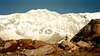
Trekking in this area is a beautiful experience. The area is well inhabited, giving the trekker ample opportunity to visit with the locals and learn the culture. Scenery is incredible, and trekking can be as easy or as difficult as you like.
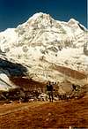
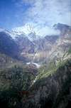
Trekking possibilities are quite varied, but most will start at Pokhara. The circuit trek to the Annapurna Sanctuary will take at least 10 days, but allow 14 to have time to enjoy it and to allow for unforseen events. The route up the narrow Modi Khola river valley is quite wet and slippery and quite steep in a few places. It can be a bit dangerous. The trail up to the Annapurna basecamp is a more serious undertaking.
There are numerous circuits in this area and many people combine many of them. To get the latest route possibilities I would strongly recommend getting the book called "Trekking in Nepal" by Stephen Bezruchka.
 |
 |
 |
 |
 |
Giving Back
I have had the honor and pleasure to meet two of the directors of the Alex Lowe Charitable Foundation, (Jenni Lowe and Conrad Anker) and would encourage your support for this non profit organization and its activities to help the climbing people who live in remote regions of the world.
The Alex Lowe Charitable Foundation provides direction and financial support to community based humanitarian programs around the world in memory of Alex Lowe. Currently the foundation is involved in establishing a climbing school for Sherpas as well as the Babu Chirri School Project to build schools in the Khumbu region where Babu was from. The organization is also active in promoting climbing safety and technique in Mongolia. There is very little overhead in this operation, and a very high percentage of donations go directly to benefit the projects. You can show your support by making a tax deductible donation to:
Alex Lowe Charitable Foundation
PO Box 6666
Bozeman, MT USA 59715
The Alex Lowe Charitable Foundation
External Links
- nepal-dia
Best page on the annapura circuit by far. many beautiful photos, very good discription of the trail. Plus many more features including prices on the trail and space pictures. Written in five languages: English, French, Italian, Spanish and German. - Virtual guide to trekking in Nepal
The most complete "virtual" guide to the Annapurna circuit, as far as I know. Includes also some other main trekking areas - More Good Stuff on Annapurna Circuit and region
Another summitpost page with lots of good information for those interested in traveling this area.
Additional Information
If you have information about this mountain that doesn't pertain to any of the other sections, please add it here and I will update the page.
 |
kilimanjaro1 - Jan 16, 2006 12:25 am - Hasn't voted
Untitled CommentWell, there is Annapurna I and Annapurna South. There is often confusion. Perhaps that might account for the variation. When you list a mountain Summitpost automatically supplies the coordinates. I have to rely on the summitpost coordinates--- last time I was in Nepal we didn't have handy GPS info.
desainme - Jan 16, 2006 6:17 am - Voted 10/10
Untitled CommentThe existing co-ordinates appear to be about a mile south of the summit and is definitely Annnapurna I not very close to Annapurna South I think the latitude is more correctly at the 28.595. I found this at
Terraserver.com (not terraserver.microsoft.com). The longitude is hard to improve upon because of the long east-west ridge.
You can really zoom in on the mtn. at terraserver.com and as you hover the mouse, the coordinates will appear in boxes over to the left of the aeriel photo. For some reason Google Earth messes up this mountain as it does those around Zermatt.
dmiki - Jan 11, 2006 4:00 am - Hasn't voted
Untitled CommentAccording to http://www.tourism.gov.np/1310peaks.htm (if it is correct (and due to the state of their website it might not be)), shouldn`t the geo coordinates of the peak be:
28.5958, 83.8222 ?
(Where did you get your coordinates from?)
thx
Michael
kilimanjaro1 - Jan 16, 2006 12:25 am - Hasn't voted
Untitled CommentWell, there is Annapurna I and Annapurna South. There is often confusion. Perhaps that might account for the variation. When you list a mountain Summitpost automatically supplies the coordinates. I have to rely on the summitpost coordinates--- last time I was in Nepal we didn't have handy GPS info.
desainme - Jan 16, 2006 6:17 am - Voted 10/10
Untitled CommentThe existing co-ordinates appear to be about a mile south of the summit and is definitely Annnapurna I not very close to Annapurna South I think the latitude is more correctly at the 28.595. I found this at
Terraserver.com (not terraserver.microsoft.com). The longitude is hard to improve upon because of the long east-west ridge.
You can really zoom in on the mtn. at terraserver.com and as you hover the mouse, the coordinates will appear in boxes over to the left of the aeriel photo. For some reason Google Earth messes up this mountain as it does those around Zermatt.
dmiki - Mar 24, 2008 6:09 am - Hasn't voted
First winter ascent3 February 1987, Jerzy Kukuczka and Artur Hajzer (PL)
Scott - Mar 30, 2016 10:15 pm - Hasn't voted
Correct CoordinatesTo add to the discussion, I believe the correct coordinates are as follows: 28.596111 83.820278