

|
|
Mountain/Rock |
|---|---|
|
|
9.122°S / 77.604°W |
|
|
Download GPX » View Route on Map |
|
|
Mountaineering |
|
|
22132 ft / 6746 m |
|
|
Overview
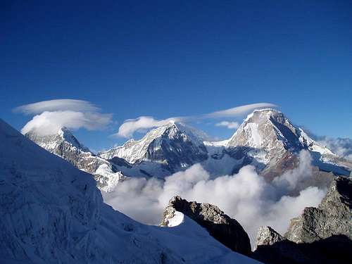
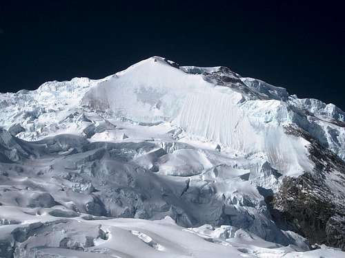
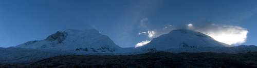
Chopicalqui, Huascarán Sur and Norte from the NNE
Together with Chopicalqui, the twin summits of Huascarán form the Huascarán massif. Huascarán Sur is the highest mountain in the Cordillera Blanca as well as in the whole of Peru, and consequently quite popular. The south summit is 91 meters higher than its (much less frequented) northern twin. The saddle between them, Garganta, lies at 6010m.
The first ascent of Sur was on July 20, 1932 by H. Bernard, P. Borchers, E. Hein, H. Hörlin and E. Schneider, as part of a German-Austrian expedition. In fact, while this expedition saw many first ascents, its main purpose was to survey the Cordillera Blanca, which resulted in the first version of the Alpenvereinskarte. The current version[1] is still the best map of the area - even if many summit elevations are a bit too high.
Norte was climbed as early as 1908 by Annie Peck, an American schoolmistress, who believed at the time that it was the highest of the two.

The E face and NE ridge from Chopicalqui
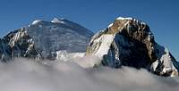
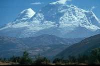
Sur and Norte from Pisco
Depending on the conditions, the difficulty of the normal route to Huascarán Sur (via Garganta and the NW-face) varies from PD to AD. In some years, the hardest part is to get to Garganta, in others the icefall higher up, on the NW-face, is more difficult. In 2011, the route to Garganta presented only relatively minor difficulties. That year, the crux was a steep section high on the NW-face.
The W-face (the shield, D+) can be gained from the ascent to Garganta, too. Moreover there are lots of very hard (TD, ED) lines on the NE and E face of Huascarán Sur.
Getting There

View from Musho. Sur is on the right
Lima international airport has direct connections to a few major cities in Europe and North America, and many more in South America.
Huaraz is the capital of the Ancash region, and by far the largest city. From Lima, you may be able to fly to Huaraz airport, which lies north of Huaraz itself. Occasionally, there are commercial flights to and from Lima, but usually the service doesn't last. In 2011, I saw an ad that there would be regular flights again, starting in a few days, but I think it didn't take off. However, when Huaraz keeps growing, at some point I expect there to be a regular service.
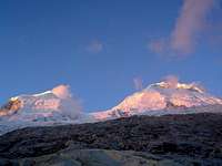
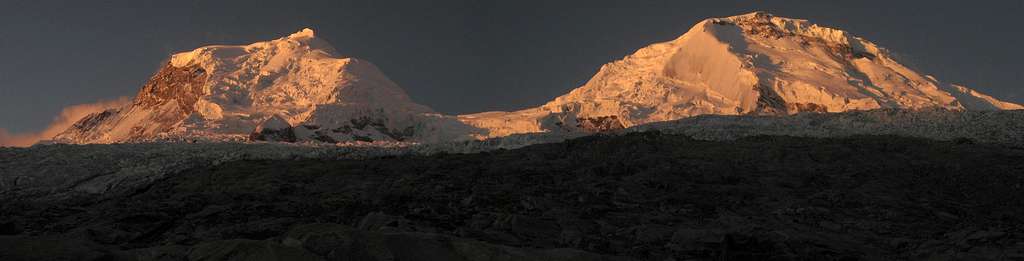
Alpenglow on Huascarán
Most travelers come to Huaraz using one of the long distance bus services. Thanks to improving roads, it's about 7 hours from Lima. And although, officially, there is a luggage weight limit on the buses, the surcharge is low, and the weight is not checked very rigorously anyway. Two good bus companies are Cruz del Sur and Movil Tours.
From Huaraz to Musho by taxi takes about 1.5 hours. Prices are not set: to Musho we paid 200 Soles (70 US $), but the return trip was only half that. A much cheaper option is to take a collectivo to Mancos and a taxi to Musho from there. It doesn't take much longer, but keep an eye on your gear.
Approach and Camps
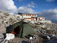
Camping right next to the refuge
Up to Campo Dos (see below), the normal route is the same for both Huascarán summits.
In Musho (3000 to 3100m, depending on where exactly you start) you can easily hire arrieros (mule drivers, 10$/day) and burros (mules, 5$/day) to reach the base camp at the same day[2].
You can also hire a more expensive guided trip in Huaraz $130/guide/day + burros + arrieros + transport ...![3]
Base Camp: at 4200m following the mule track from Musho (3-4h). Water available. There are also some unpleasant biting insects around.
Refugio "Don Bosco" Huascarán: 4650m, 1.5h from base camp. Local food, beverages and bunk beds and, if you're lucky, a hot shower.
Moraine Camp: 4800m, 2h from base camp. Water available during daytime. Actually, there are many possible camp sites between the refuge and the edge of the glacier.
Campo Uno: at 5300m on the glacier (about 4h from the refuge).
Campo Dos: at 5850m at the W end of Garganta (4-5h). See also "Objective Risks".
From Musho to Huascarán Sur along the normal route and back. For the original version of this trail, see Huascarán Sur at EveryTrail.Recorded by Lyngve Skrede.
Routes
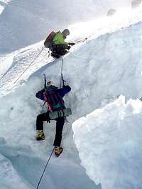
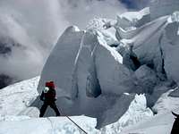 Rappelling in the icefall below Garganta, 2008
 A steep bit coming up, in the NW-face above Garganta, 2011. The crux is higher up.
Normal Route (PD/AD):
From BC follow the cairns and gain the edge of the glacier W of the south summit at about 5000m. Ascend the glacier towards the S side of the big ice fall (Campo Uno at 5300m). Find a route through the ice fall (5400-5800m) and then traverse N-wards to reach Campo Dos, just below Garganta.
Cross a few large crevasses to get to Garganta proper. Now find a way up the NW-face, a more or less 40° slope, with many crevasses and possibly some steep bits - in 2011, the crux was one 60-80m high 60° section, just below 6300m, which made Sur slightly harder than Norte, with an estimated rating of AD. After that, it's a long slog to the summit over some easier slopes. Beware of hidden crevasses here.
According to Byron, in 2012 there was a widening crevasse on the route that had to be jumped, and some guided parties turned back there.
See this section for updates!
In 2011, the Shield looked magnificent, but it was not in good shape. There was a large gap below the northern edge (on the left in this photo), the southern edge was threatened by seracs higher up, and the ice in the center was rock hard and it was almost impossible to get an ice screw in.
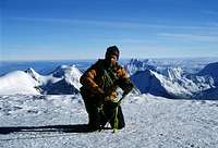
On the summit
The Shield (D+):
The name derives from a mitre-shaped ice wall in the west face of Huascarán Sur, looking like an upside-down shield. The Spanish name is Escudo. The route diverges from the normal route at about 5800m where the traverse to Garganta begins (a high camp may be possible). From here one has to gain the northern edge of the shield (approx. 6000m) which leads up to the normal route (NW slopes) at 6400m.
Objective Risks
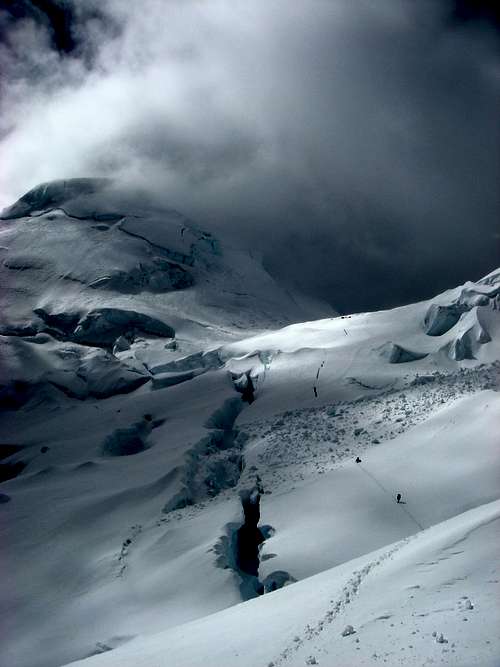
Bad weather descending upon Campo Dos
This section is not meant to prevent you from climbing Huascarán. But it points out the fact, that - though rated "only" PD in ideal conditions - you should meet Huascarán with respect. There are plenty of reports of climbers who did not experience a simple walk up.
Icefall: The access to Garganta is endangered by unpredictable icefall. It seems to have increased in the first decade of the century. Notably, there are two active avalanche zones you have to cross shortly before Campo Dos. You'll see the debris fields when you get there - be fast. The classical site for Camp 2 at Garganta was hit by icefall in 1997 and 1999 (several victims). See also here.
Avalanches: Storm and snow form avalanches in the early season and after snowfall during the climbing season, too.
Read the report of an avalanche accident at ca. 6400m killing four climbers on 5 June 2002.
Crevasses: The route to and above Garganta is changing frequently due to crevasses and seracs. Especially by night it can be a problem to negotiate them.
Strong winds and low temperatures: At and above Garganta you must be prepared for heavy storms even when the general weather conditions are good. Night temperatures below -25°C are not uncommon.
Clouds: Finally the clouds forming around Huascarán in the morning often do not rise above the summit and can cause a white-out.
 A difficult passage in the icefall below Garganta, back in 2004
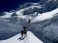 An easier icefall in 2011
The difficulty of the peak
Huascarán Sur and Norte from Pisco
Huascarán, like the Cordillera Blanca as a whole, is changing a lot due to the change in climate. During the first decade of the century, the normal route was often too difficult or too dangerous. The objective dangers are still substantial, but by 2011, the difficulty of the route to Garganta wasn't a problem anymore, but it was still AD higher up.
Red Tape
The Cordillera Blanca is a national park, named after its highest mountain: Parque Nacional Huascarán. If you want to visit, you need a ticket. It's 65 Soles, in 2011. On the official ticket it says "Valid for 7 days", but there seems to be some confusion about that. An experienced mountain guide told me that it was not correct, even though the ticket says so, and that it was valid for a month. After that, I only bought a new ticket when my old one was a month old.
Huascarán from Yanapaccha
More importantly, if you want to climb any mountain in the Cordillera Blanca, you must either go with a guide, or get written permission from a park official. I found the people at the National Park office in Huaraz always very friendly and helpful in obtaining one.
The permit is free, but to get it, you have to prove that you have enough experience. The easiest way to do that is to show your alpine club membership card. The unspoken assumption is that mere membership equals experience. A scary thought, when you to think about it, but at least this will weed out most of the ill-prepared ones. The formalities also require you to provide the details of your insurance policy. However, if you end up in trouble, don't count on a rescue operation. Normally there isn't even a helicopter in the area, and if, by any chance, there is one, it may not be able to fly high enough to save you.
For the record, on two trips to Huascarán, I was never asked to show my ticket or permit, but on several occasions near the trailheads to other mountains I was. So, best to be prepared and have that paperwork in order.
When to climb
Although Peru lies on the southern hemisphere, it's not far from the equator and temperature differences over the seasons are relatively small. However, as the seasonal weather patterns see significantly less precipitation by late fall through early spring, that's the best time of year to go. In winter you can have long periods without any precipitation, and days that typically start with clear skies, followed by buildup of clouds covering the high summits, then clearing again later on. For climbing, that means that you want to aim to be on the summit early in the morning. For camping, you can almost count on many beautiful sunsets from high camps with a free view to the west.
 7 am: early clouds on Huascarán
Early on in the dry season, chances are that some of the slopes have unconsolidated powder left from the last snowfalls. Amazingly, unconsolidated powder sticks to 60° slopes! By the end of June, the thaw-freeze cycle of the strong sun and cold nights will have transformed most of it into a stronger and safer surface. Steep southern faces, seeing less sun, are the last to consolidate.
Strong winds can happen at any time of the year, especially on the highest mountains like the Huascarán summits, but are somewhat more likely by the end of the season. All that combined, that makes July the best month for climbing, closely followed by August and June.
1970 and 1962
Huascarán from the south
At 3:30 in the afternoon on May 31, 1970 an earthquake struck the region of the Cordillera Blanca. It was one of the worst natural desasters in the history of South America killing more than 80 000 people in the region and leaving a million homeless.
The most shocking catastrophe was the burial of the city of Yungay under an alluvion triggered by a massive rock slide in the west face of Huascarán Norte. More than 20 000 inhabitants died - only a few hundred survived as they ran up to the cemetery hill behind the town. This cemetery and four palm trees from the Plaza de Armas are the only remains of the town.
When you visit old Yungay you will propably find one of the survivors telling their story to the tourists for a small tip. They describe the muddy wave that crested, crushed an than buried the city as "eight stories high". Today a new Yungay has been built not far away.
The total volume of the alluvion was calculated between 50 and 100 million cubic meters, covering more than 22 square kilometers to a depth of up to 80 meters. See aireal photo of 1970
Back in 1962 about 4000 people were killed by a massive landslide.
A BBC report about the catastrophe.
Maps, Books and References
Huascarán from the north
[1] The best map is the Alpenvereinskarte 0/3a Cordillera Blanca Nord (Perú), 1:100000.
[2] Casa de Guias in Huaraz is a good source of information and can help you finding a guide, porters, et cetera. Alternatively, there are many outfitters in town, happy to provide anything from transport to the trailhead to a completely organized climb.
[3] There are a few small agencies in Musho that can provide mules and porters. I was happy with the services provided by
Agencia de Viajes Turismo Callejon de Huaylas
Abraham F. Cordero Villar
Av. 5 de Julio 504
Musho - Yungay
943034994
[4] John Biggar: The Andes - A guide for climbers, 3rd edition, 2005. ISBN 0953608727.
[5] Brad Johnson: Classic Climbs of the Cordillera Blanca, 2009 revised edition. ISBN 9780975860618. Highly recommended.
[6] David M. Sharman: Climbs of the Cordillera Blanca of Peru, 1995. ISBN 9780952358206.
[7] Juan José Tomé Nacle: Escaladas en los Andes (Guía de la Cordillera Blanca), Ed. Desnivel 1999. ISBN 9788489969438.
[8] Antonio Gómez Bohórquez and Juan José Tomé Nacle: La Cordillera Blanca de los Andes, Ed. Desnivel 1998. ISBN 9788487746994.
External Links
The sun rising over the summit
Short reports on an ascent to Huascaran and several other Peruvian peaks. Good photos!
Nuestra Montaña gives recent information about the Cordillera Blanca.
Nice trip report about a climb while breaking trail.
 Alpenglow on Huascarán, seen from the refuge