
|
|
Mountain/Rock |
|---|---|
|
|
19.10167°N / 99.7675°W |
|
|
15391 ft / 4691 m |
|
|
Overview
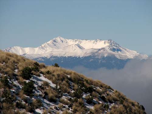
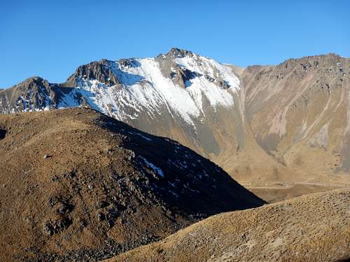
At 4,691 m (15,390 ft), Nevado de Toluca is Mexico's fourth highest mountain and offers perhaps the best moderate alpine climbing in Mexico. The elevation is either 4691 meters (15,390 feet) or 4704 meters (15,433 feet), depending on which map you look at. The Aztec name for the peak is Xinantecatl which is most commonly translated as Naked Lord, but other possible translations are Lord of the Corn Stalks or Mountain of the Bats.
Geologists and Volcanologists believe that Nevado de Toluca may have once been as tall as Popocatepetl, but a huge eruption about 25,000 years ago reduces the summit height by up to 900 meters/3000 feet. There have been no major eruptions since 10,500 years ago.
Since the mountain lies to the west of Mexico City, which is the opposite direction from the other high volcanoes, it is neglected by many climbers who visit Mexico. This peak is a great destination in its own right though and also serves as a great acclimatization peak for those heading to Iztaccihuatl or Orizaba.
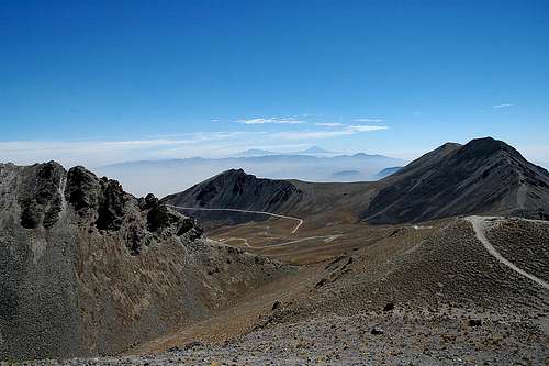
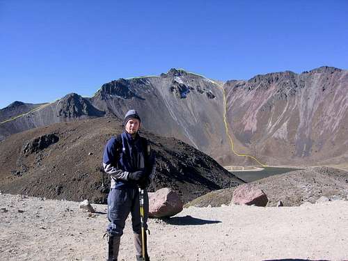
In addition to the solitude of its ridges, the mountain provides a stunning setting for climbing, since its crater contains two large lakes (Laguna de la Luna and Laguna del Sol). These lakes are extremely cold, yet scuba diving is still practiced by some very brave divers. Several Aztec artifacts have been found in the lakes.
There are some nice hiking options around these lakes which also appeal to non-climbers. On weekends, many Mexicans flock to the mountain, but most only visit the crater lakes.
Access to the volcano is easy, since a rough road (passable by 2-wheel drive cars) leads all the way to the National Park Hut at 4050 meters/13,287 feet. There are slodging options along this road, including at the National Park Hut at 4,050 m (excellent for acclimatizing). A trail leads from this hut directly into the crater in about 1-2 miles.
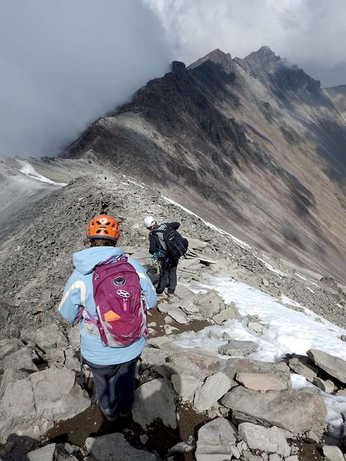
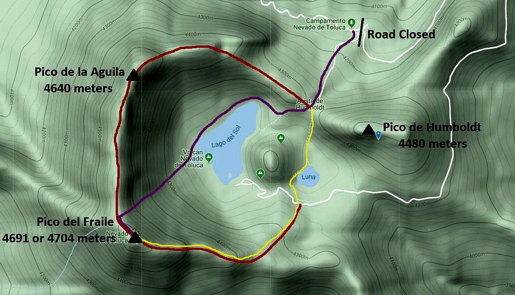
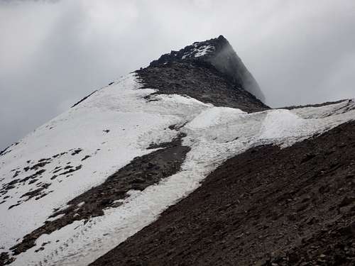
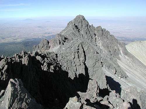
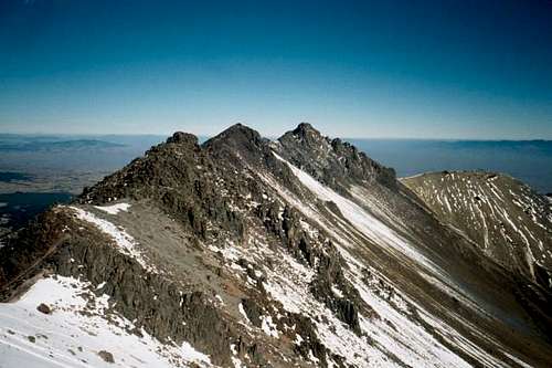
The western-most portion of the crater rim is a 3-4 mile jagged ridge in which a number of rocky peaks are encountered. The highest peaks are known as Pico de Fraile (4,691 m; 15,390 ft) and Pico de Aguila (4,620 m; 15,157 ft). All routes offer some nice scrambling on Class 3 to Class 5 rock including the ultra classic Complete Rim Traverse.
Getting There
By Car from Mexico City (from Secor and maybe out of date, it's best to use Google Directions!)
Follow Highway 15 west from Mexico City towards the city of Toluca. Before the city, take a bypass (Paseo Tollocan) which leads south around the city. At the southern edge of Toluca, turn left on Highway 134 and be aware that the road turns right in 1.2 mi (2 km). Continue on Highway 134 for 11.2 mi (18 km) to reach Highway 3, which branches off to the left toward Sultepec. There is also a sign here which indicates the Park and Volcan de Nevado de Toluca. Follow Highway 3 for 5 mi (8 km) to the gravel road which leads up to the peak (also signposted for the park and the volcano). The gravel road winds 9 miles (15 kms) around the mountain to the National Park Hut. You are no longer permitted to drive to the crater.
By Bus from Mexico City
Flecha Roja (Red Arrow) offers shockingly frequent bus service to Toluca from Mexico City's Observatorio bus station, also known as Mexico Central Poniente. The trip takes a little over one hour. Taxis can then be taken from the station to any of several hotels in the center of town.
A taxi can be hired in town to take you all the way to the crater (or to the hut at 4,050 m) for around $30, if you're negotiating skills are good. Make sure the driver understands that you need to go almost completely to the end of the gravel road. You can arrange for the driver to pick you up again after your climb.
It is also possible to travel by bus all the way to the aforementioned gravel road. Take a bus from Toluca towards Sultepec and get off at Raices. From Raices, it is usually fairly easy to catch a ride to the National Park Station/Hut.
From the National Park Hut
Once at the National Park Hut, a brief straight and steep trail that gains 500 feet/150 meters or so leads down into the crater. To climb the peak you then need to cross the crater and ascend the ridge from the other side. This probably adds perhaps two miles/3 kms round trip and some 1000 feet/300 meters of cumulative gain to the climb compared to the old trailhead in the crater.
The old road continues on from this closure for foot or bicycle traffic, but it seems much too long to merit travelling that way on foot for a climb. It's better to take the trail.

Routes Overview
There are many routes that can be used to climb Nevado de Toluca. The most popular routes are discussed below and are marked on the below map. Click on the Route Page Links for more information on each route.
The Northeast Slopes and North Ridge Route and East Ridge of Pico Fraile routes can be done without any mountaineering equipment, but under icy and snowy conditions and ice axe, crampons, and ropes are needed. A helmet is recommended for all routes.
Northeast Slopes and North Ridge Route
This is one of the two standard routes to Pico del Fraile, the highest summit of Nevado de Toluca. From a technical standpoint, this is probably the least technical route, but the route up to the ridge is very steep. From the ridge, it is an enjoyable class 3 climb to the summit.
This is the other standard route up Pico de Fraile. It isn't as steep as the Northeast Slopes and North Ridge Route, but it has more scrambling and is slightly more technical. There are class 3 and 4 sections on the ridge.
Pico Aguila
The most popular route is a class 3 and 4 scramble from Arista de Humboldt.
This classic climb is probably the most alpine route in Mexico and resembles some of the climbs in the Alps (PD+ to AD-). It is probably the best route on the mountain and traverses all of the main summits. Some parties use a rope on the traverse, even in dry conditions. If the route is snowy and/or icy, a rope, ice axe, and crampons are needed.
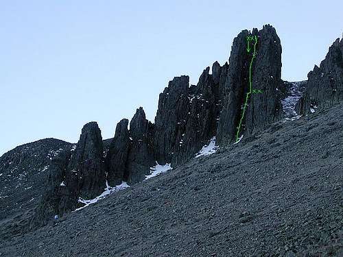
This techical climb ascends a detached pillar on the north side of the crater. It is one of the few truly technical rock climbs on the Mexican Volcanoes.
Other Routes
Maps show various routes and or trails on the mountain on the west and east sides. This are longer routes and many might take more than a day. Consider any such routes to be an adventure in route-finding, though they will offer a much less crowded climb than the standard routes.
Red Tape
A small fee is required to enter the Park and can be payed at the National Park Station.
On weekends, the park receives far more visitors than it can handle and the road becomes jammed with cars facing in all directions. If at all possible, avoid weekends!
There is no camping allowed in the crater or beyond the National Park Hut.
When To Climb
The dry season is November through March, which is the best time to climb. April and October can be good, but May through September tends to be wet with rain and snow.
November may be the best month since it is by far the least crowded month in the dry season.
You won't be allowed to pass beyond the park gate when the weather is bad.
Camping
There are essentially two options for lodging on the mountain.
1) Family Lodge at Los Venados is about 3 km up the gravel road and offers 14 rooms for $3-4. It is open on weekends only and no reservation is necessary. The entrance fee is payed here and camping is also permitted.
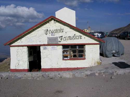
2) National Park Hut (Posada Familiar) at the Crater Gate (4,050 m) is a basic hut that located about 15 km up the gravel road (6 km from the crater) and has room for about 7 guests. The cost is $10 and there is no reservation system. On weekends, snacks, tacos, soda, and bottled water can often be purchased from local vendors. The park guards occupy an adjacent building and should be willing to watch your gear while you are out climbing.
Camping is allowed on the mountain, but not in the crater.
Guidebooks
RJ Secor's guidebook for Mexico's Volcanoes: A Climbing Guide is one source of information on climbing Nevado de Toluca and some of the other higher mountains in Mexico. The book is quite outdated though and the information isn't better than what is on this page.
The Climbers and Hikers Guide to the World's Mountains and Volcanoes has lots of good information on the mountains in Mexico.
For complete information on getting to Mexico and traveling around I highly recommend the Lonely Planet guidebook on Mexico.
Mountain Conditions
CLICK FOR NEVADO DE TOLUCA WEATHER FORECAST
Weather averages for Nevado Toluca at elevation 14,052 feet/4283 meters are below. The temperature on top will be a few degrees cooler.
| Month | High (° F ) | High (° C) | Low (° F ) | Low (° C) | in. Rain | mm Rain | Rain/Snow Days |
| JaN | 45 | 7 | 27 | -3 | 0.60 | 15.3 | 2.7 |
| Feb | 46 | 8 | 28 | -2 | 0.52 | 13.2 | 2.6 |
| Mar | 49 | 10 | 31 | 0 | 0.49 | 12.4 | 2.5 |
| Apr | 50 | 10 | 32 | 0 | 2.22 | 56.4 | 6.6 |
| May | 50 | 10 | 32 | 1 | 4.58 | 116.4 | 13.4 |
| Jun | 49 | 9 | 33 | 0 | 8.06 | 204.6 | 19.9 |
| Jul | 47 | 8 | 33 | 0 | 9.59 | 243.5 | 24.5 |
| Aug | 47 | 8 | 33 | 0 | 8.98 | 228.1 | 23.0 |
| Sep | 47 | 8 | 33 | 0 | 8.21 | 208.4 | 21.2 |
| Oct | 46 | 8 | 31 | 0 | 3.46 | 87.8 | 12.6 |
| Nov | 45 | 7 | 29 | -1 | 1.07 | 27.1 | 4.5 |
| Dec | 45 | 7 | 28 | -2 | 0.59 | 15.1 | 3.0 |