

-
 425906 Hits
-
 99.87% Score
-
 153 Votes
|
|
Mountain/Rock |
|---|---|
|
|
19.03024°N / 97.26814°W |
|
|
Hiking, Mountaineering, Scrambling |
|
|
Winter |
|
|
18491 ft / 5636 m |
|
|
In Memoriam
On Saturday, November 20, 2010, Chris Pruchnic (Haliku) lost his life in an ice-climbing accident in Colorado's Rocky Mountain National Park. Haliku was a valued contributor to SP, but his worth went well beyond the pages he created and is missed very much both from friends who have climbed with him, and by anyone who asked him for advice about climbing. I am honored to be able to continue managing this page and I believe it is in the best interest to keep as much of the text Chris wrote intact and that's exactly what I will do. Anything added will be clearly marked and credit will clearly be given to sections written by Chris. Although I never had the chance to meet him, he will be missed and as a member of the climbing community, he will never be forgotten. Written below is a beautiful tribute from one of his long time friends.
He always was willing to give a hand or advice to anyone in anyway that he could, and he always wanted to share his joy of climbing and exploring other cultures with his friends and fellow climbers. The climbing community and the world needs more people like Chris, not less, which makes the tragedy of his early parting so much more difficult to accept. He will live on in our hearts and memories. He and I had been talking about climbing Kilimanjaro soon, and someday when I stand atop that peak I will call Chris' name to honor my friend. --chicagotransplant
Overview
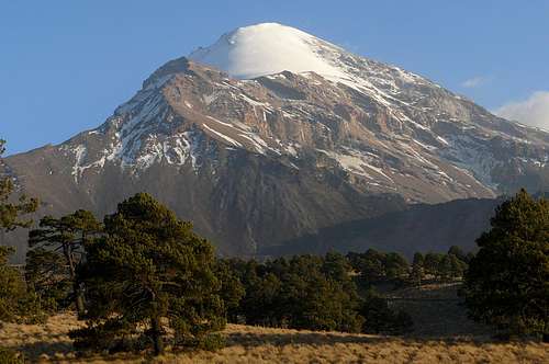
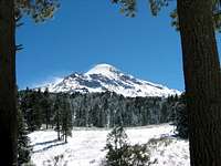
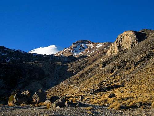
El Pico de Orizaba (known as Citlaltépetl which means Star Mountain) is a striking volcano. From the west it towers over the town of Tlachichuca in the form of a beautiful white cone. The glacier starts around 4900-5000m and covers the upper aspects of the mountain. Pico de Orizaba is the highest mountain in Mexico and the third highest in North America after Denali and Mount Logan. Orizaba makes for an excellent first experience at high altitude.
One issue with this mountain is the numerous published summit heights that you can find. Anywhere from 18,400 feet to 18,900 feet are claimed as the true height of the summit. With the increased reliability on GPS numerous informal and at least one scientific survey has been taken to determine the true height of the mountain. According to Stephen Brown, a professor at the University of Texas--San Antonio, they recorded the height at 18,490.5 feet with a +/- 50 feet.
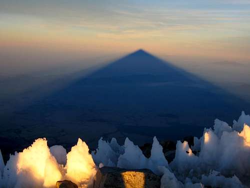
One very memorable aspect about climbing Orizaba is the shadow the mountain casts on the surrounding flat plains when you stand on the summit at sunrise. Witnessing this effect has been the highlight of many climbers' trip, including my own. See the profile photo above for an idea of what this looks like. It's something that truly takes your breath away!
Overview Section Written by Chris and Matt
Getting There

Almost there!
Planning
The following trip reports give an overview of the entire trip from planning to climbing. Half the fun is getting there!
| Informative Trip Reports |
| |
 Sunrise at the glacier's edge
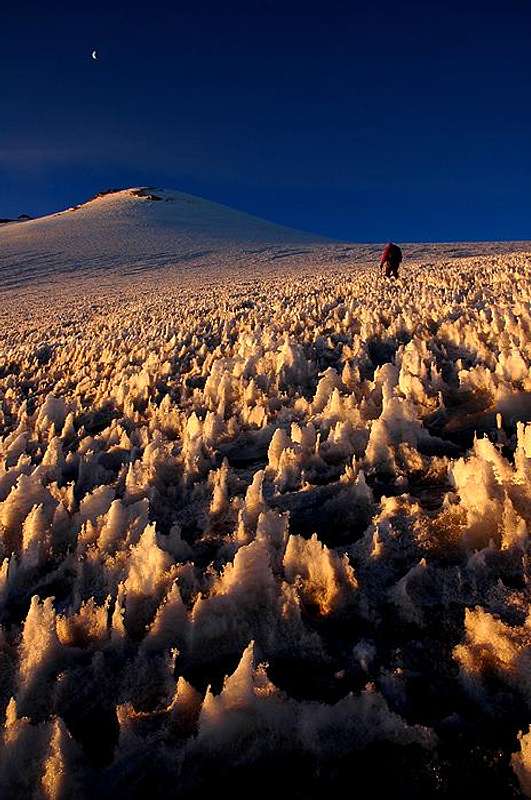 Jamapa Glacier
Getting to Tlachichuca
Most people fly into Mexico City due to the numerous flight options, but Puebla or Veracruz also make for reasonable starting points. The Puebla airport is very orderly and efficient. A taxi into central Puebla is about 150 pesos. If you stay in Puebla the central area around the zocalo has numerous options for lodging, shopping, dining and sightseeing. Another option is to stay near the bus depot where you depart from for Tlachichuca etc.Tlachichuca is the starting point for most climbers attempting El Pico de Orizaba. To get there from the Mexico City airport, you can take a taxi to La Tapo, which is the main bus station for points east of Mexico City. The cost for bus rides to Tlachichuca is between 100 to 250 pesos. Although many people use the bus system to get from their arrival airport to various towns and trailheads, some people would prefer to avoid them due to instances of losing their gear either at checkpoints or due to someone robbing the bus. There have also been a few cases where drug cartels have hijacked a public transportation bus and robbed tourists but recently, this has declined significantly and this has only been an issue closer to the US/Mexico border or coastal cities like Veracruz.
If you do decide to avoid the bus system, you can hire a private driver (different than a taxi) who will be able to pick you up directly from the airport and take you and you gear where ever you need to go. This is what I did when I climbed Orizaba and it worked out very well. Not only will you get around more efficiently, but you will have someone to talk to on the ride and feel a little safer. Taking a taxi can sometimes lead to being ripped off. Listed below is the best option for a private driver. Antonio is very nice and very reasonable on pricing. Although it will be more expensive than buses or taxis (around $100 per person for just Orizaba), it's well worth it. Hiring a driver is actually better if you are in a large group. Antonio has both a large van and a Volkswagon car. His van can carry up to 8 people including gear and will be cheaper since you can split the cost with the amount of people in your group.
Jesus Antonio Juarez Guzman044-55-39080-242 celljajuarezgu@yahoo.com.mx
Many people I know, as well as myself, have used Mr. Antonio Guzman for complete transportation needs, and he remembers every one of us! He will pick you up right from the airport and take you anywhere you need to go for a reasonable price.
Getting There Section Mostly Written by Matt
Logistics
 Servimont Main Door
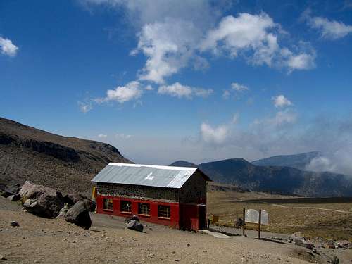 Piedre Grande Hut
 Limon's Hostel
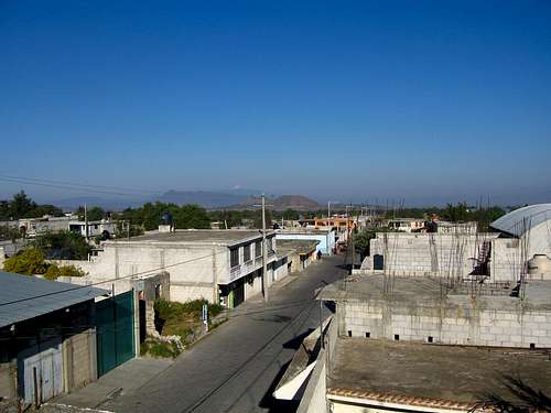 The town of Tlachichuca
 Standard Transport
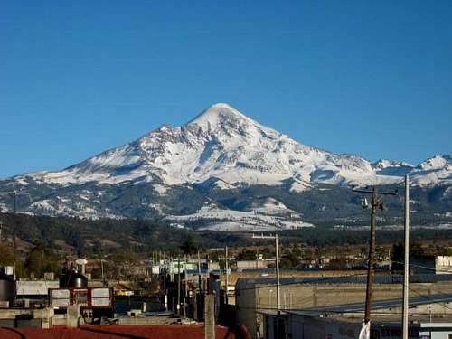 Orizaba with fresh snow
Servimont
Joaquin Canchola Limon
Guides
Transportation
Red Tape
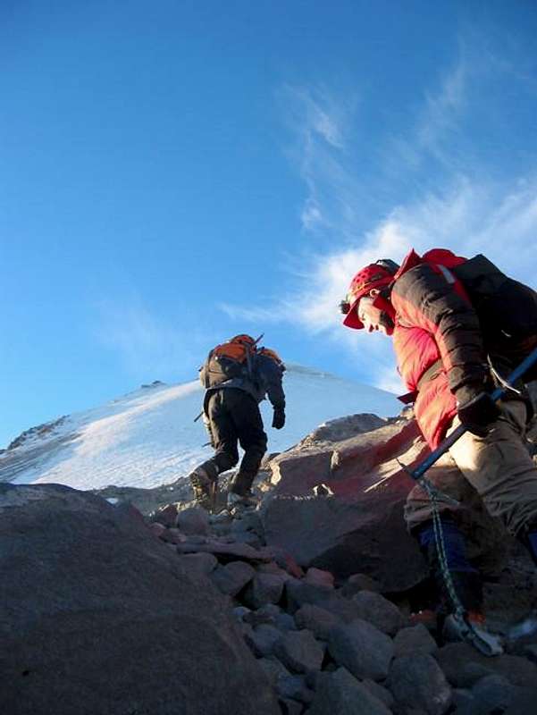
When To Climb
 After the storm cleared
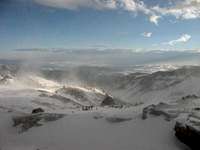 End of the storm
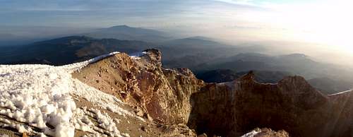
Orizaba's Crater
Camping
 Piedra Grande
 Inside the Hut
Supplies
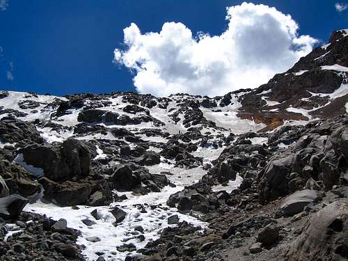
The Labyrinth in March 2012
Standard Jamapa Glacier Route Map
Map above generated by Matt - Zoom in and out or change the map type using the drop down menu in the upper right corner.
Beyond the Jamapa Glacier
 Glaciares Orientals
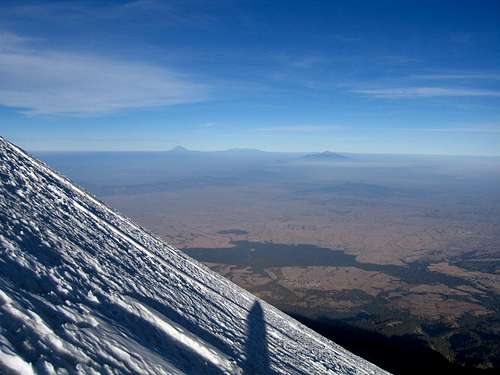
Typical steepness on the Jamapa
Sunrise from the hut
 Ice Route
Possible Schedules
If you're already acclimated:
Day 1 - Fly into Mexico City, take a taxi to La Tapo, catch a bus to Tlachichuca, find hotel accommodation, purchase food, water and supplies, arrange a ride to the hut in the morning, get a good night rest. I had good luck eating in the market for all meals. Most likely you'll be eating with the locals as well as other climbers, or your lodging will include food.
Day 2 - Catch the ride up to the hut and relax for the afternoon. There are many trails leading above the hut (start of the standard route) you can hike for a bit to loosen the legs from the uncomfortable 2 hour jeep ride.
Day 3 - Summit via the Jamapa Glacier Route and return to the hut by 2pm and catch the ride back to your pre-planned lodging in Tlachichuca. Celebrate with beers!
Day 4 - Return to Mexico City
If you are not acclimated:
Day 1 - Fly into Mexico City, find lodging and walk around the city for a while. Mexico City is quite high and will be good to spend your first night here to begin the acclimatization process. Purchase some last minute supplies like food and water. Arrange a ride to Tlachichuca in the morning, get a good night rest.
Day 2 - Catch a ride to Tlachichuca, explore the town and try some of the local eateries. Find lodging and relax. Schedule your jeep ride to the hut for the next morning.
Day 3 - Take the 2 hour jeep ride to the hut and take a short walk to explore the area around camp. Make base camp, cook a nice meal and drink lots of water. Sleep the night either in the hut or your tent.
Day 4 - Depending on your fitness, you may be able to try for the summit on the 4th day, but it's best to wait another day at camp. Also nice to have a built in bad weather day. You could also move your camp up to the base of the Labyrinth to make the summit day shorter.
Day 5 - Climb to the summit (leave no later than 2-3am) and return to camp. Ideally you would return to the hut by 2-3pm and catch the ride back to Tlachichuca and celebrate.
Day 6 - Return to Mexico City
Traversing the crater rim
Further Info
Summit Photos
 Orizaba's shadow Orizaba's shadow | 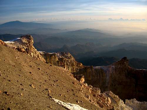 Looking into the crater Looking into the crater | 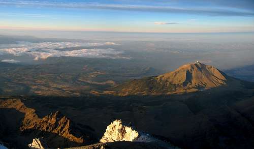 Summit View at Sunrise Summit View at Sunrise |
Scott - Aug 22, 2007 2:35 pm - Voted 10/10
Re: Altitude correctionIf you are interested: No matter where you are, guides will probably usually use the highest elevation available. Anyway, it is 100% certain that Orizaba is around 18,400-18,500 feet rather than 18,700 feet as some older sources state. SRTM data confirms this and 18,700 is for sure an error. The latest Mexican topographic survey puts the peak at 18,409, close to the height listed on this mountain page. SRTM, topographic surveys, and the figure posted on the mountain page are all fairly close.
Corax - Aug 22, 2007 3:35 pm - Hasn't voted
Re: Altitude correctionhttp://www.viewfinderpanoramas.org/elevmisquotes.html#mexico
Curtissimo - Oct 30, 2009 6:48 pm - Hasn't voted
Re: Altitude correction5610 meters (18,406') is the number now officially issued by the Mexican government (INEGI) as well as Secor and the Encyclopedia Britannica. Wikipedia uses 5636 M (18,491').
AlpineFun - Jan 31, 2016 7:30 pm - Hasn't voted
Re the Joaquin hostelA quick review of Joaquin Canchola Limon hostel - aka the Cancholas Family Hostel - having stayed there with a group. The pros: the people are friendly, they make their livelihood off the service and know the logistics well and drive you up to the basecamp hut, and you can leave stuff at the hostel while you go up to Orizaba. The cons: The beds in the hostel are very uncomfortable (we put our camping pads on top of the so-called mattresses and it was still quite uncomfortable), the food was mediocre at best, you are sharing 3 shower/bathrooms with potentially a lot of people, and the prices are outrageously high. Yes it's a hostel so these conditions are to be expected, but the prices do not reflect that. If you break up the costs to separate out food and transportation, it's still $50+/night per person, with 3 or more people in a room -- i.e., $150+/night for a somewhat dirty room with no amenities. If you don't want to think about the logistics and don't mind spending a lot of money for it, then it's not a terrible option. But know that it's ridiculously overpriced for what it is.
jklloyd81 - Feb 16, 2016 2:58 pm - Hasn't voted
Update: Crevasse DangerFebruary 8, 2016 on the standard Jamapa Glacier route: I was making a solo ascent of the peak, convinced that crevasse danger was minimal from all I had read online. I broke through the surface of the glacier at 18100', fell 8 meters to the crevasse floor, and spent the next 24 hours trying to get out of a 3 meter wide crevasse. I was eventually rescued. I feel compelled to advise climbers that this mountain is changing. Large crevasses do exist. One nearly took my life. I will return to Orizaba, but only as part of a roped team. In the spirit of common sense, I invite others to do the same.
steevo - Dec 15, 2016 4:15 pm - Hasn't voted
Lodging/Transport option.Oso of Orizaba Mountain Guides also now has a bunk house/hostel He has 4x4's and water logistics as well. . He is in "Zoapan" which on maps is "San Miguel Zoapan." It is closer to the mountain than tlachichuca and is a 2 dollar cab ride from tlachichuca. The lodgings were really good and the food was awesome. Zoapan is smaller and with less amenities than tlachichuca but I believe Oso's services may be cheaper. Worth contacting to find out. Also from Puebla you want to take the "VALLES" bus line to Tlachichuca. This information seemed to be hard to find (for me), but is quite simple at the Puebla bus station. The changing of buses in Puebla is very simple if you are coming from D.F (mexico city). The ADO allows you to check your bags and they are secure. Watch your stuff (sit passenger side over looking the baggage compartment) while riding the Valles line.
jeanpaulnoahrodney - Jan 5, 2017 10:35 pm - Hasn't voted
Re: Lodging/Transport option.We just used Orizaba Mountain Guides and were very happy with everything. Having everything taken care of (lodging, food, transportation to and from the mountain, guides, and gear rentals) made it much easier. We rented a car in Mexico City to get to Zoapan, which worked out, but going on the bus might have been more relaxing.
jeanpaulnoahrodney - Jan 5, 2017 10:45 pm - Hasn't voted
Acclimitazation is important for an 18,400 foot mountainI hope people will remember how important it is to acclimitize for Orizaba. Mexico City is about 7000 feet, most lodges/hostels near the mountain are at around 10,000 feet and the hut/refuge is a little over 13,000 feet. We met many people who were unsuccessful at attempting to summit after just one day at their lodge, and coming from home cities that are at sea level. In my opinion this is not a safe thing to do.
gimpilator - Feb 24, 2017 12:05 am - Voted 10/10
Wrong CoordinatesCurrently the peak displays in the town of Orizaba. Try these and it should fix the problem (19.030498, -97.269848).
amovasagi - Mar 17, 2017 1:46 pm - Hasn't voted
Orizaba March 2017 UpdateJust got back from a 2 week Mexico volcano climb. Used Roberto's Orizaba Mountain Guide service for the whole trip. We customized the OMG-7 trip and was very ready and acclimated for the Pico do Orizaba climb. The OMG lodge was very comfortable, with hot showers, comfortable rooms and great food. They are located in the village of Zoapan which is higher and closer to the Piedre Grande hut. Juan was my guide throughout the trip and provided great service. All other posts regarding climbing Pico de Orizaba are accurate. Feel free to contact me with any questions.
MishaCZ - Apr 18, 2017 4:30 pm - Hasn't voted
Orizaba in late March 2017We climbed Orizaba, Izta and Nevado de Toluca, great trip. We used a small local company called Nómada (Mexican Travel and Adventure) - really good price and good service!
jeanpaulnoahrodney - Nov 27, 2017 10:48 pm - Hasn't voted
U.S. Climber Dies, Others Rescued November 26, 2017This past week one U.S. climber was killed on Orizaba and several others had to be rescued. It is imperative that people are aware of the risks when climbing Orizaba and how valuable it is to use a local, highly qualified guide and that you have experience with crampons, ice axes, and crevasse rescue. When we climbed last year (with OMG) there were many people trying to go on their own and were not only unsuccessful, but two needed rescuing. We also witnessed a woman tumble down the glacier. Had her husband not been able to tackle her, she would have gone off a cliff. This past week's tragedies put not just those who were rescued at risk, but all the people involved in the rescue. Rescuers were injured, and I am sure many are exhausted both physically and emotionally. The Mexican climbing companies and villagers are heroes, in my opinion. They volunteered to help strangers. Even if you think you are experienced or tough or whatever, do yourself a favor (and others a favor), hire a guide. It is the smart thing to do. Don't be cheap and don't try to be macho. Our family would hate to learn that a Mexican lost their life helping someone who had no business climbing Orizaba.
Matt Lemke - Nov 27, 2017 11:08 pm - Voted 10/10
Re: U.S. Climber Dies, Others Rescued November 26, 2017While I respect your position, I would like to add to what you mention here. You are correct that many people attempt Orizaba who have no business being there without a guide, and those people should indeed hire a guide! Please don't take offense, however, it's a little narrow minded to say that EVERYONE should hire a guide to climb this peak. There are many people who have climbed much larger, more difficult peaks who certainly wouldn't need a guide to ascend Orizaba. Perhaps many people with that level of skill wouldn't bother climbing Orizaba, but either way, skilled climbers should be free to climb the mountain on their own. I agree though that people attempting to climb without the knowledge, skill, gear, or endurance endangers not only themselves, but others on the mountain as well, and they should be guided assuming they at least have met a required pre-requisite level of fitness. Just wanted to clarify my views on this matter. May those who perished RIP, and the ones who aided are indeed very selfless and heroic.
Yulia Zi - Jun 13, 2018 5:05 pm - Voted 10/10
Re: U.S. Climber Dies, Others Rescued November 26, 2017I totally agree with Matt. I climbed Pico de Orizaba with my friend and mountaineering partner at a time back in Nov 2016. While we took longer than other more fit and altitude experienced climbers, we had no guide but we were comfortable with our crampons/ice axe/navigation skills. I hope I don't face the day where I need to be rescued at my own fault. Pay attention to the situation, have basic mountaineering knowledge, communicate at all times and it's totally doable. One error I did is missing a breakfast due to the alpine start. That was the first and last time I ever did that before the big day of climbing.
WillPelton - Sep 28, 2018 5:36 am - Hasn't voted
Crater CampingHas anyone ever spent the night at the summit or in the crater or Orizaba? I can't find anything online showing someone has. Anyone here have any thoughts on That? Thanks for any replies, Will.
Matt Lemke - Dec 25, 2018 7:32 am - Voted 10/10
Re: Crater CampingI don't recall seeing an easy way to drop into the crater while I was there, but then again I wasn't looking too hard. It looked pretty sheer drops into the crater from the rim. If you do find a way please let us know!
DaveCovill - Dec 11, 2019 8:48 am - Hasn't voted
Orizaba thoughtsI've climbed Orizaba 3X now. I agree with the other posters; a guide is not necessary if you possess the skills required. Certainly use caution, rope up if that is in your best interests, and spend the time to acclimate. I was on the mountain right after a fatal accident in 2015, and conditions were icy then. Other times they have been wonderful with fresh snow and firm footing. You never know what shape the mountain will be in, so come prepared. The advice on how to make a phone call is lacking; to call from the USA to either of the two Hostels, or a guide, requires the following: For Canchola House (Maribel speaks excellent English) use 011 52 245 451 5082 011 gets you to an international call 52 is the Mexico Country Code the rest is the phone number; do a similar sequence for anyone else down there. I have to disagree with the poster from 2007; Canchola House is clean, food is good, and prices are reasonable. I have visited the Servimont compound and Senor Reyes, but have not stayed there. Prices are similar, but Servimont is a true hostel and to me is Euro-style, you stay in a bunkhouse, manage your own food unless Servimont is paid to provide it. Canchola House provides breakfast and dinner with their price, which is still around $150pp for 2 nights lodging before & after, breakfasts and dinners included, and transportation to Piedra Grande Hut. They can arrange for a Cuidador (tent guard/liaison person) for minimal $$$. They can also provide large ~20L water jugs, and even US canister fuel for your stoves, a rarity in Mexico. We always use our own tents, and camp a hundred yards away from the Hut, which is at best crowded, smelly, noisy. Yes, the pit toilets are always a concern. We dayhike the peak after suitable acclimation hikes, including La Malinche, Sierra Negra, and of course to the Labrynth section at ~ 15,500 - 16,000' on Orizaba. I have found, via perhaps a dozen different GPS units over the years, that the Hut is at 14,000' exactly, and the Summit is at 18,475'. I agree totally that Antonio Guzman is an excellent choice for transportation from Mexico City to Tlachichuca, and other points of interest. His rates are reasonable, and his English is good. Great guy. He can handle up to 8 or so in his large van, and he can procure an additional driver as needed. He knows where to stay, eat, etc. Another guide who has hundreds of ascents on Orizaba and Izta is Vicente Azpeitia. Vicente can provide transportation to a smaller group of a few climbers, and will accompany the group to other peaks. His English is Fair at best, so it would be in your best interests to have at least one member of the team have a moderate ability to speak Spanish. Again, great guy. vicenteazpeitia@yahoo.com.mx Finally, if you find yourself in the city of Puebla halfway between Mexico City and Tlachichuca, perhaps while climbing La Malinche, seek out the Puebla Plate Lady. Her name is Concepcion Perez, and she sits on a street corner near the famous market alley. She creates artwork on a plate via finger painting with acrylic paint. Her subjects are of course the volcanoes; Popo, Izta, Orizaba. Cost is minimal, perhaps ~$10. She made 8 or so for us in a few hours while we had dinner nearby. Close examination of the finished work reveals the fingerprints, amazing how she does it. She wraps her pieces in plastic wrap to keep them clean until you get home, careful of fresh paint not drying when wrapped tightly... She speaks Zero English... http://www.pueblaplatelady.com/
adriaacarlos - Feb 22, 2020 8:47 pm - Voted 10/10
Logistics UpdateSERVIMONT $850 MXN round trip (Tlachichuca- Piedra Grande) - 11am drop off and 4pm return the following day CANCHOLA $700 MXN round trip (Tlachichuca- Piedra Grande) They are flexible. This is the most popular option so it may take a while before you are put in a car on Mexican holidays OSO / (OMG) ORIZABA MOUNTAIN GUIDES $700 MXN round trip (Tlachichuca- Piedra Grande) +52 1 222 632 5881
SFARELS - Oct 18, 2021 11:34 pm - Hasn't voted
Oct 2021 Summit of Pico de OrizabaMy group summited Pico de Orizaba on Thursday October 7, 2021. We stayed at the Canchola's Guesthouse. Mirobel, our host, was fantastic. Mirobel is a terrific hostess; very comfy Hostel and delicious food. We arrived in Tlachichuca on Monday PM, drove to Piedra Grande on Tuesday, had an acclimatization hike on Wednesday, and departed 1:00 AM Thursday for the summit. We had a brilliantly beautiful day, with full view of the shadow of the peak over the countryside. We summited about 11 AM and were back at hut by about 4:00 PM. Coming from Chicago, I wish we would have had at least one more day to acclimatize. Also, bring a bit more water than you think you will need; there is no access to water on the Mountain. This was a wonderfully beautiful and, at the same time, brutal experience. For travelers from the US, at this time there is no testing or vaccine requirement to get into Mexico (please check to see if policies have changed prior to your trip), however you will need a negative COVID test within 72 hours of your arrival in the US to be allowed back into the US. I found a clinic 1 block from the Canchola site (2-3 minute walk). This was the Robert Koch clinic, and results were available in 15 minutes. They give you a printout of results, with a QR code that can be scanned at airport. The address: Av. Benito Juarez, No. 13 Col Centro, Tlachichuca. We also employed Mr. Guzman (Jesus Antonio,Juarez Guzmen) to bring us from the Mexico City Airport to Tlachichuca, and to the Mexico City Airport for our return. His prices were very fair, and we felt safe with him. Highly recommended! Great guy! +52-55-3908-0242; jajuarezgu@yahoo.com.mx This is an absolutely stunning area and mountain; be aware of the altitude, and acclimatize. Bad weather can come in quickly. Be prepared. Great Experience!!!
FDaly2 - Aug 29, 2023 6:19 pm - Hasn't voted
Any recent experiences on orizaba logistics or transportationLooking for any recent feedback / info on: - guide services offering lodging and transport to trail head at Piedra Grande - Do we need to be concerned about having someone to watch our tent, sleeping bags, etc. while we are actually climbing? - Are white gas type camping stoves (e.g. MSR Whisperlite) the best option for Mexico? - private transportation options from Mexico City airport thank you