
|
|
Mountain/Rock |
|---|---|
|
|
38.32786°N / 47.84795°E |
|
|
Download GPX » View Route on Map |
|
|
Iran |
|
|
Mountaineering, Ice Climbing |
|
|
Spring, Summer, Fall, Winter |
|
|
15784 ft / 4811 m |
|
|
Overview
Sabalan (4811 m.) [Sabalân/Sāvālān] is an inactive volcano in NorthWest of Iran. It rises in starting zone of Alborz mountains as the 3rd highest summit of Iran.
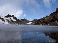
An small lake is placed at the top, which is created in the volcano hole. The lake frizes 9 or 10 months a year.
more info at wikipedia
Details
The mount, the extinct crater, and the lake can be ascended usually from the northern and southern tracks. When on top, you can see a panorama of the beautiful region for more than a hundred kilometers all around you.
The lake occupies an area of 100 by 50 meters, and is 15 meters deep. Since it is covered with ice from mid-September through early June the next year, mountain climbers use it for skating
Many people climb it every year , the routin path is easy but there are also hard routs and glacial valleys.
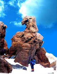
Eagle statue: The most beautiful creature among these is an eagle statue seeming to maintain control over the Sabalan slope and valley from atop.
The mount represents a myriad of attractions in various seasons of the year, to the extent that upon reaching the peak, one feels having arrived in a land of dreams. Many hot mineral spas and cold water springs originate from its slopes and attract millions of tourist to the region every year. The hot water is said to have effective healing properties.
Getting There and Climbing
Ritching to Ardabil is possible by airplane or by bus from Tehran. Then you have to go to Meshkin shahr. Before Meshkin shahr, in a place with name: "Lahrud" or "Laree" you must turn to left and go to south until Southern face of Sabalaan.
There are two famous warmsprings, firs "Ghotursoui" and second: "Shabil" which is nearer to Sabalan. There is a gravel road from Shabil to shelter of Sabalaan. Only heavy vehicles can pass this road. From shelter you can climb the slope of summit in south direction, from the left side of southern galcier.
Camping

No problem to camping. Around the south face shelter or west saddle shelter is better. Also it is possible to camping in warmsprings such as "Ghotursoui" or "Shabil".
Tent and sleeping bag and warm clothes are necessary for camping.
MAP1 and MAP2 are including completed details about shelters.
Click to see western shelter.
When To Climb
From June to September is the best. The other mounthes you need winter clothes and perfect equipments.
Taking tent is better even at summer, beacaus the shelters are full of poeple mostly.
Red Tape
No permit and payment is required (now is 2019).
Hunting is forbidden.
During the summer eastern shelter usually is crowded.
DANGERS:
1- Be careful of bear attak around the shelter at night!
2- Be careful of sheepper's dogs attak on the path to the shelter!
3- Be careful of the west deep valley while you are on the return path from the top! Get right edging to get rid of losting true path. Left hand there is that rounding deep valley! Return path is exactly toward a mountain in front of you.
Nyle Walton - Sep 2, 2005 9:33 am - Hasn't voted
Untitled CommentIt occurred to me that Sabalaan is exactly the same altitude as the highest peak in the Alps. However it is less picturesque and glaciated.
Damavand - Sep 7, 2005 5:04 pm - Hasn't voted
Untitled CommentYes , and in winter is very hard to climbing .
riosambesi - Jun 13, 2015 8:21 pm - Hasn't voted
SabalanHi there, in august I´m going to visit Iran and and the ascent of Sabalan is one of my major wishes for that trip. What other mountains in that area could you recommend for acclimatisation? Greetings from Germany Michael
petr - Jul 5, 2016 9:12 am - Hasn't voted
Sabalan, 2 July 2016The shelter in question is not on southern side of the mountain but on NE side as is the town Lahrud, the starting point for going up. The climb is not so difficult but there are easy and less easy parts. However, the most tricky thing is orientation. I strongly recommend first goers to join some local group or at least load waypoints on their GPS. The road up is not obvious (especially when you start early in the night) and road down is even less so (in the lower part). As far as the altitude is concerned, my GPS (Garmin Fenix 3) showed finally 4830 m. The shelter was according to the device in 3666 m.