
|
|
Mountain/Rock |
|---|---|
|
|
27.70670°N / 86.86920°E |
|
|
Hiking, Mountaineering |
|
|
Spring, Fall |
|
|
21247 ft / 6476 m |
|
|
Overview
View from the summit of Mera Peak
Mera Peak is usually, and perhaps incorrectly, regarded as the highest official trekking peak in Nepal. The confusion stems from its altitude and location being misreported by the Nepal Mountaineering Association. See the section on the real Mera Peak below.
In any case it remains a popular destination due to its easy standard route, which requires only basic mountaineering skills to achieve an altitude considerably higher than a European or North American peak. For many years the climb was Alpine Grade F (Facile / Easy), but due to recent summit block changes the final 30-40 meters has become Grade PD (Peu difficile / not very hard). See Recent Updates section below.
In addition the Mera Peak trek is superb. The Hinku and Hongu valleys are spectacular Himalayan wilderness.
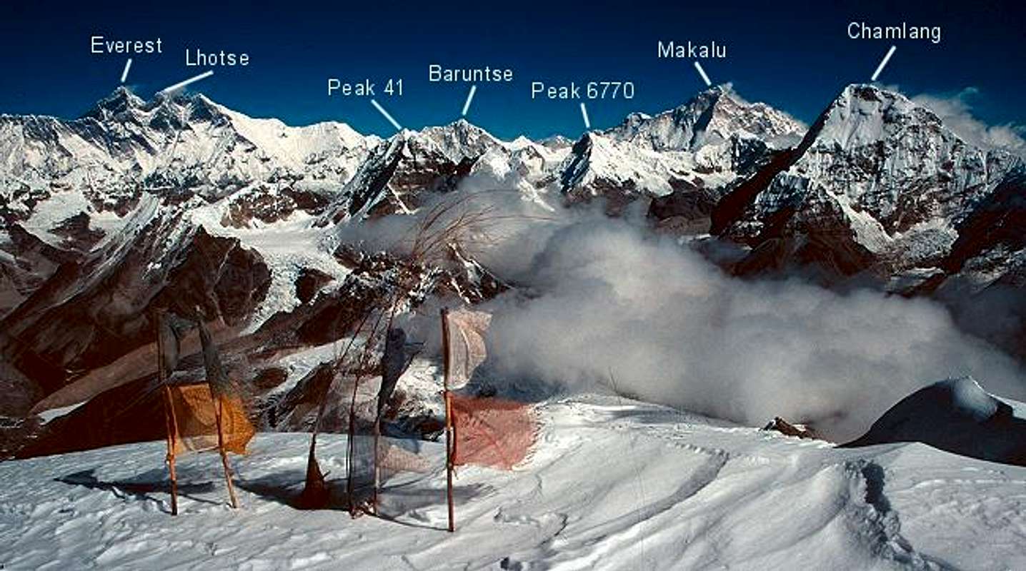
From the summit of Mera one can see 5 of the 6 highest mountains in the world: Everest, Kangchenjunga, Lhotse, Makalu, and Cho Oyo. The standard route from the north involves little more than high altitude glacier walking. The ease of reaching this elevation may be its biggest danger but good weather and snow conditions are, of course, necessary for safety and success. The west and south faces of the peak offer difficult technical routes.
The first ascent was on May 20, 1953 by Col. Jimmy Roberts and Sen Tenzing. The region was first explored extensively by British expeditions in the early 50's before and after the ascent of Everest. Members of those teams included Edmund Hillary, Eric Shipton and Geroge Lowe.
(Jimmy Roberts (1916-1997) was probably the person who can take most of the credit for establising the trekking industry in Nepal in the early 1960's. He was posthumously awarded the "Sagarmatha (Everest) National Award" by the government in May 2005.)
 |  |  |  |  |
Getting There
The normal approach is to make your way to Lukla by land or air. Then instead of heading north towards Namche Bazaar and Everest, trek east towards the ridge of peaks that divides the Dudh Kosi from the Hinku Valley. Cross the Zatrwa La (15,000’ / 4600m) then descend steeply to the Hinku. Go north and east for for 2-3 more days to reach the Mera La (17,767’ / 5415m). The summit is now to the south and can be reached in one or two days of glacier travel.Proper acclimatization is key to having a good chance of reaching the summit. Our group used the following camps with most members acclimatizing well. This schedule put us on the summit 12 days after leaving Lukla.
- Lukla (9,186’ / 2800’)
- Chutanga (11,115’ / 3400m) – 2 nights
- Tuli Kharka (14,436’ / 4400m) – after crossing Zatrwa La
- Tashing Ongma (11,489’ / 3500)
- Tangnag (14,108’ / 4300m) – 2 nights
- Khare (16,729’ / 5099m) – 3 nights
- Mera La (17,767’ / 5415m)
- High Camp (19,028’ / 5800m)
- Summit and return to Mera La
Spending the night at the high camp is highly recommeded, both for its awesome views, and for the higher success rate in reaching the summit. Nine of ten people in our group summited from the high camp. Another group of ten that we met had only four of ten summit, but they tried to climb from Mera La to the top in one day.
The return can backtrack, or better yet, you can descend the east side of the Mera La into the totally wild Hongu Valley. Trek north with the awesome precipices of Chamlang on your right to Panch Pokhari (Five Lakes). There you cross the Amphu Labsa, a difficult pass of 19,193‘ / 5850m. The amazing Lhotse south face is staring right at you. The steep descent takes you past Imja Tse (Island Peak), another popular trekking peak, to Chukung and then back onto the normal Everest trekking routes.
 |  |  |  |  |
When to climb
The typical eastern Himalayan climbing seasons apply: April-May before the monsoon, or October-November after it, more or less. I have seen some oufitters book this trip during the Christmas holiday season, but in my opinion it would be excessivly cold and dark then. |  |  |  |  |
Red Tape
Peak permits required, can be obtained in Kathmandu. As of November, 2001 the cost starts at US $350 for a group of four. Check the Nepal Mountaineering Association website for the latest details.If you cross the Amphu Labsa you will enter Sagamartha National Park and will need a park permit as well. Most outfitters handle getting these permits as part of the trip cost.
Some discussion of the term "trekking peak" might be in order here. This does not mean, as might be assumed, an easy peak that someone can climb while on a trek. Some "trekking peaks" such as Kusum Kangru have turned back the most determined and skilled climbers. It is more of a legal term that applies to a group of peaks listed by the Nepal Mountaineering Association for certain permit and fee structures. The ease or difficulty of reaching a summit is not implied.
Recent Updates
I recently attended a slide show given by friends who climbed Mera in November, 2003. There have been several changes to the region since my 1994 trip that should be mentioned. The main ones are:- There are now lodges in the Hinku valley all the way up Khare. In 1994 there was just one yak herder hut at Tangnag. It is now probably easier to do the Mera trip with just a few porters. The Hongu valley remains undeveloped, so continuing up to the Amphu Labsa requires more logistical support.
- October 2003 information from Mathias Zehring, who reports that the summit block of Mera Peak has changed from when I was there in 1994. The crevass that was making its way up this north-eastern face now extends across the entire face. This blocks the line of ascent I used, which went up to the right of the crevass. Matthias' line followed the left (east) skyline. This is steeper and more exposed than the route I took.
- April 2009 information from Robin Baks, who wrote, "I climbed Mera Peak on april 23th. The normal route cannot be climbed anymore due to an enormous crevass at approx. 30/40 meters below the summit. Most teams stop her. You can only reach the summit from the north> side. You'll have to climb a steep part and use a fixed rope. On the Photo of the Summit you can see the crevass 'splitting' the Summit in two. You can see the track to the right site of the summit. Behind the ridge on the right site you can climb a steep part of snow/ice to the top (approx 30/40 meters). This is now the only way to reach the summit." Robin reports that this change has altered the climb grade from its traditional Grade 'F' to the next more difficult Grade 'PD'. Thanks for the information Robin.
The difference in 15 years:
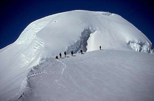
My photo of summit block from November, 1994. The crevass now blocks ascent from this side.
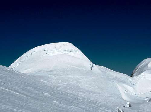
Robin Baks' photo from April, 2009. You can see the track circling the summit block to the right.
Summit View Photographs
The view from the summit of Mera is fantastic. Starting from high camp instead of Mera La increases your odds of reaching the top before the clouds roll in, so you can savor where you are. Have a look at these photos. |  |  |  |  |
Mera from Everest
Since one can see Mount Everest from Mera Peak it follows that Mera is visible from Everest. Here’s the proof.The photos are courtesy of Kiyoshi Furuno, leader of the Nihon University Everest Expedition 1995. This expedition made the first ascent of the Northeast Ridge of Mount Everest. This is the route that claimed the lives of British climbers Peter Boardman and Joe Tasker in 1982.
 |  |
Hero Photos
This is for the obligatory summit photographs. |  |  |  |  |
Will the Real Mera Peak Please Stand Up?
It appears that many people who think they climbed the highest trekking peak in Nepal made a wrong turn! That Mera Peak is north of the Mera La, not south, and is known as Peak 41. There are no easy routes to its summit, which at 6654 meters, is nearly 200 meters higher than this Mera Peak.
Whatever the case, those of us who ascended Mera 6476 are following in the venerable tradition established in W. E. Bowman's The Ascent of Rum Doodle and can take pride in having climbed the wrong mountain. (Since I wrote this it has been generally agreed to keep the name Mera for the peak we have all climbed, and Peak 41 for the "Real Mera", even if all of our permits had the wrong map coordinates!).
Mathias Zehring supplied this information:
First climb of Peak 41, "Real Mera" in 2002, done by Slowenian team over the west face (1500 m, TD+, WI V/4)
See the Alpinist climbing notes: Peak 41 First Ascent.
The photos below show Peak 41, "Real Mera Peak".
 |  |  |
After the Flood
On September 3, 1998 an earthquake of magnitude 5.8 struck eastern Nepal. The epicenter was about 20 km east-south-east of Namche Bazaar. This caused the collapse of the lateral moraine of the Dig glacier above Tagnang and triggered a huge flood as the waters of the Sabai Tsho Lake were drained. Several villagers living downstream were killed. Here are before and after photos of the valley by Tangnag. |  |  |  |
External Links
- CIWEC Clinic Travel Medicine Center
Health information for travel in Nepla, including altitude issues for trekkers.
Nelson - Jan 11, 2006 6:07 pm - Hasn't voted
Untitled CommentHi Michael,
The odds are that the coordinates are the ones that were on the page when I took it over from WIlliam. I don't recall changing them, but that was years ago. Where did you get your numbers from, since the page you reference says Mera Peak Lat 27 46 27 Long 86 54 40?
In any case, the position of Mera is of some controversy, as I'm sure you are aware. See this page from the Real Mera site.
I looked at the interactive map satellite photo, and the current position seems pretty close, judging by where the Sabai Tsho and Dudh Kund lakes are located. Comapre with this Nelles map. (Make sure your browser does not shrink it to fit the screen).
Let me know what you think.
- Nelson
dmiki - Jan 12, 2006 12:52 am - Voted 10/10
Untitled CommentHi Nelson,
>Where did you get your numbers from
I used the formula from http://www.summitpost.org/mountains/faq.pl#MP_TOPO : "Recalculate the DMS-data (dd° mm' ss.sss'') with the following formula (only mm and ss have to be recalculated):
xxxx = (mm / 60) + (ss.sss / 3600)."
I really don`t know where to find reliable data on Nepalese peaks. I am quite disappointed with nearly all of the maps available here (Kathmandu). I just thought their own ministry might have some trustworthy info on their website - apparently not.
Michael
dmiki - Jan 11, 2006 3:14 am - Voted 10/10
Untitled CommentAccording to http://www.tourism.gov.np/peaksopedfortrekking.htm (if it is correct (and due to the state of their website it might not be)), shouldn`t the geo coordinates of the peak be:
27.7742, 86.9111 ?
(Where did you get your coordinates from?)
thx
Michael
Nelson - Jan 11, 2006 6:07 pm - Hasn't voted
Untitled CommentHi Michael,
The odds are that the coordinates are the ones that were on the page when I took it over from WIlliam. I don't recall changing them, but that was years ago. Where did you get your numbers from, since the page you reference says Mera Peak Lat 27 46 27 Long 86 54 40?
In any case, the position of Mera is of some controversy, as I'm sure you are aware. See this page from the Real Mera site.
I looked at the interactive map satellite photo, and the current position seems pretty close, judging by where the Sabai Tsho and Dudh Kund lakes are located. Comapre with this Nelles map. (Make sure your browser does not shrink it to fit the screen).
Let me know what you think.
- Nelson
dmiki - Jan 12, 2006 12:52 am - Voted 10/10
Untitled CommentHi Nelson,
>Where did you get your numbers from
I used the formula from http://www.summitpost.org/mountains/faq.pl#MP_TOPO : "Recalculate the DMS-data (dd° mm' ss.sss'') with the following formula (only mm and ss have to be recalculated):
xxxx = (mm / 60) + (ss.sss / 3600)."
I really don`t know where to find reliable data on Nepalese peaks. I am quite disappointed with nearly all of the maps available here (Kathmandu). I just thought their own ministry might have some trustworthy info on their website - apparently not.
Michael
LS - Nov 27, 2013 4:15 pm - Hasn't voted
brain-dead organizersThis is so funny! Even after they change the normal route from 2010 (because of a crevasse near the central summit), organizers still continue to do the lower Central Summit (false summit), although the slightly higher North Summit is both easier and not any further away. So with the new route from 2010, people now go to the saddle between Central and North Summit and from there they climb the WRONG summit. What the fuck! I quote: "The south summit (6,065m) is the most accessible with the Northern Summit (6,476m), the highest, which can be reached by skirting the Central Summit (6,461m) to the north and following a snow ridge to its top. Climbing the Central summit requires ascent up on steep snow and is more technical. Mera North is straight-forward to climb." Westerns come a long way to do a 6000m peak, but the scammers in Kathmandu brings them to a bump on the ridge (Central summit) which lately has become more "technical" than the true summit (North summit). It's a contradiction I can't understand. The organizers in Nepal are totally brain-dead. They operate as they always have done on Mera Peak. They are not able to CHANGE. They just operate by old habbits. What a bunch of scammers. Maybe they don't know any better, because they just sit in their office, they are never out in the field. Then they instruct the sherpa's to do the false summit, the one they have always done. What a bunch of loosers ! For more information about the controversy, please read here: http://www.markhorrell.com/diaries/090504.html
alaska13 - Nov 29, 2013 4:15 pm - Hasn't voted
Re: brain-dead organizersPeople still climb the central "peak"? Not the summit guys. A friend and I did this climb years ago(sniped it).. Lukla back to Lukla in 3 and a half daze.. no acclimatization.. not recommended. I think we forgot to get a permit. We reached the central summit, and were pretty tired, when we both agreed the north summit was higher.. and climbed that as well. So now it is more difficult, and people STILL climb it? Pretty silly. We were the only people in the valley, and on the mountain when we did it.
rakaraul - Feb 24, 2014 11:49 am - Hasn't voted
Mera peak in Mayhi Nelson, I am my friend are planning to do mera peak during late april - early may. How is this season? We are planning to do it on minimal budget. Here is out plan for this. 1) Take agency's help to get Permit and Hire an experienced guide in Lukhla . I am against taking guide from Kathmandu to save his ticket cost. 2) We will meet guide in Lukla. 3) From Lukla to Khare. I guess its a tea house style trek with lodges and villages. We can carry our own stuff. And we dont need to carry porters, equipments and food till then. 4)From Khare we will hire Porters. Take food, equipments ( tent, harness , ropes, ice axe etc.. ) . We will hire them for 3-4 days . Khare - Mera peak - Khare. 5) Khare - Lukla . Back with our guide. How does this sound?? Any part of my plan which is not feasible?? Let me know. My id is rakaiit@gmail.com
CarmenB - Jan 4, 2015 7:38 pm - Voted 9/10
Re: Mera peak in MayWe - a group of four - did Mera Peak last October as we were advised to go right after monsoon season and before most of the big expeditions. Well, might have been better to go with a date in spring - somehow the monsoon started too late this year and when we came to Kathmandu (end of September) it was still raining. Our flight to Lukla was cancelled several times. Only a few days later we could start the trip. But it had bad weather most of the trek up to Khare and back, and we were even lucky to have had a weather window on summit day, some other groups were not as lucky. As we did the summit with touring skis (skipping Base Camp and directly going to High Camp) we had our porters right from Lukla - we had a lot of gear - but if I would go again (without skis) I guess I might also take it the light weight way. There are lodges to sleep in if your group is not too big and you can rent everything you need in Khare. That's definitely one should take advantage of. As LS wrote before, the Nepali guides are completely inflexible, have their fixed schedule and stick to it. If we weren't as insistent as possible and did a lot of research before the trip, some things would have been done differently and at least I wouldn't have reached the summit as I required a rest day in Tangnag our guide didn't want to make. Well, a more detailed post on the Mera Peak Ski ascent can be found here (with pictures and all): https://www.facebook.com/photo.php?fbid=827531580641183&set=gm.381830638661334&type=1&theater Carmen