
|
|
Mountain/Rock |
|---|---|
|
|
35.76484°N / 82.26512°W |
|
|
6684 ft / 2037 m |
|
|
Overview
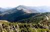
Mount Mitchell, located about 35 miles northeast of Ashville, in North Carolina's Black Mountains is the highest peak in the US east of the Mississippi River. It is linked to Clingmans Dome, the third highest peak in the US east of the Mississippi at 6,643', via the Blue Ridge Parkway National Scenic Drive. Mount Mitchell is part of the Black Mountain Crest which includes 6 other peaks above 6300' nearby, including Mount Craig, the second highest peak in the US east of the Mississippi at 6,645'. The summit is inside the Mount Mitchell State Park while many approach trails (including the Mount Mitchell Trail) start in the Pisgah National Forest. During the summer months, you can expect a variety of wildflowers to be in bloom. Trout fishing is also popular in the creeks that run off the Black Mountain Crest.
In the early 20th century, the mountain was heavily logged by several logging companies including Brown Bothers, Carolina Spruce, Dickey and Campbell, and Perley and Crockett (the largest). As part of the process, the slopes of the Black Mountains were denuded of most trees which were transported by railroad to Pensacola, NC to the west and Black Mountain, NC to the south. Narrow gauge railroad lines had been laid up on both sides of the mountain from both places. Logging was replaced by state park through the work of John Silcox Holmes (for whom Holmes State Forest is named) and Locke Craig. Holmes was appointed state forester for the North Carolina Geological and Economic Survey in 1909 and prepared a report on the forest conditions, however, logging continued until Craig was elected governor in 1913 and through their work, the State of NC passed a bill on March 3, 1915 to create a park on Mount Mitchell, likely the first state or federal park in the Southeast US.
Visitor access by railroad was available during the logging years and initial years of the park from Black Mountain, NC by Pearley and Crockett. In 1922 the tracks were replaced by a toll road and finally replaced by the Blue Ridge Parkway from Buck Creek Gap to Black Mountain Gap in 1939.
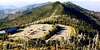
The easiest way to the summit is to drive up to about 100' below the summit and then walk up a paved path.
For those seeking to stretch their legs, a more agreeable way to reach the 6684' summit is to take the 5.6 mile class 1 Mount Mitchell Trail (USFS #190) that starts at the Black Mountain Campground (2680'). You can also create a 15.5 mile loop hike by hiking to the summit from the campground, heading north along the Black Mountain Crest Trail (USFS #179 passing Mount Craig - 6647', Big Tom - 6580', Balsam Cone 6596', and Cattail Peak 6584') and down the Colbert Ridge Trail (USFS #178) and then hiking back along some gravel roads back to the campground. During the winter it is not uncommon to have 2+ feet of snow on the mountain. See the map mentioned in the Getting There section.
 |
 |
 |
 |
 |
Getting There
The Blue Ridge Parkway mentioned below is occasionally closed. To check the latest conditions check the NCParks.gov Mount Mitchell page, the NPS Blue Ridge Parkway Real-time Road Closures page and the NPS Blue Ridge Parkway page.
SUMMIT ROAD FROM SOUTH: Take I-40 to exit 86 connecting with NC SR-226 to Marion / Shelby. From here turn left on to the Blue Ridge Parkway. At mile marker #355 turn north on NC SR-128 and drive into the park where you will enter the park, pass the Mount Mitchell State Park Office, and reach the summit parking lot a bit farther.
Black bears are prevalent in this area so bear proof your campsite. Bear bagging still appears to be effective here.
Contact the Mount Mitchell State Park or USFS for current weather conditions:
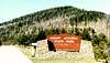
MOUNT MITCHELL STATE PARK
Route 5 Box 700
Burnsville, NC 28714
Tel: (828) 675-4611
Email: momi@yancey.main.nc.us
USFS
P.O. Box 2750
160A Zillicoa Street
Asheville, NC 28802
Tel: (828) 257-4200
SUMMIT ROAD FROM NORTH: Take US-19E to Micaville and turn south on NC SR-80 heading south. Turn right and head south on the Blue Ridge Parkway reaching NC SR-128 at mile marking #355. From here drive north into the Mount Mitchell State Park as described above.
BLACK MOUNTAIN CAMPGROUND FROM SOUTH: Follow directions for the Summit Road (from South), however, do not leave the Blue Ridge Parkway at NC SR-128. Instead continue east to US FR-472 and drive north to the Black Mountain Campground.
BLACK MOUNTAIN CAMPGROUND FROM NORTH: Follow directions for the Summit Road (from North) and head south on NC SR-80 turning off at US FR-472. Head south on US FR-472 until you reach the campground.
BLACK MOUNTAIN CAMPGROUND DURING WINTER (Ref: IamC0lin): The Blue Ridge Parkway is often closed due to ice in the winter months. If this is the case, getting to the Black Mountain Campground becomes difficult. You must travel East on 70 until you reach Marion. At which point you will travel North on 80 until you come to the small town of Busick. Shortly after passing a convenient store on your left, you will need to turn left onto Forest Service Road 472. The road may be closed but there are areas to park and often times the road is only labeled "closed" as they cannot block it off due to the fact that people live on it. You should have no trouble driving all the way to the campground.
In general there's not much red tape here unless you want to camp where you'll need a permit inside the Mount Mitchell State Park and need to pay a fee at the Black Mountain Campground.
See the Mount Mitchell State Park Rules and Regulations page for specifics including the prohibition of alcohol in the park. If you are camping you will need a permit inside the park. The Black Mountain Campground and most of the Mount Mitchell Trail is in the Pisgah National Forest.
It's possible to climb this peak year round, however, be prepared for changing weather conditions as snow storms have been known to occur during all months of the year. Temperatures on this peak have been measured as low as -34°F and never above 81°F. Average annual snowfall is 104 inches and winds often reach 100+ mph on the West Face. The fair weather climbing season generally lasts from May to October while those hiking during the winter shouldn't be surprised to find themselves in 2+ feet of snow.
During the winter months the Blue Ridge Parkway may be closed due to weather. If this is the case, follow the directions for "Black Mountain Campground From North" in the Getting There section above.
The Mount Mitchell State Park has walk-in and primitive / backpack campsites that are available for use year round. There are differing rates for the high season and the winter season so check the park website for the latest information.
BLACK MOUNTAIN CAMPGROUND FROM SOUTH: Follow directions for the Summit Road (from South), however, do not leave the Blue Ridge Parkway at NC SR-128. Instead continue east to US FR-472 and drive north to the Black Mountain Campground.
BLACK MOUNTAIN CAMPGROUND FROM NORTH: Follow directions for the Summit Road (from North) and head south on NC SR-80 turning off at US FR-472. Head south on US FR-472 until you reach the campground.
BLACK MOUNTAIN CAMPGROUND DURING WINTER (Ref: IamC0lin): The Blue Ridge Parkway is often closed due to ice in the winter months. If this is the case, getting to the Black Mountain Campground becomes difficult. You must travel East on 70 until you reach Marion. At which point you will travel North on 80 until you come to the small town of Busick. Shortly after passing a convenient store on your left, you will need to turn left onto Forest Service Road 472. The road may be closed but there are areas to park and often times the road is only labeled "closed" as they cannot block it off due to the fact that people live on it. You should have no trouble driving all the way to the campground.
 |
 |
Red Tape
In general there's not much red tape here unless you want to camp where you'll need a permit inside the Mount Mitchell State Park and need to pay a fee at the Black Mountain Campground.
See the Mount Mitchell State Park Rules and Regulations page for specifics including the prohibition of alcohol in the park. If you are camping you will need a permit inside the park. The Black Mountain Campground and most of the Mount Mitchell Trail is in the Pisgah National Forest.
When To Climb
It's possible to climb this peak year round, however, be prepared for changing weather conditions as snow storms have been known to occur during all months of the year. Temperatures on this peak have been measured as low as -34°F and never above 81°F. Average annual snowfall is 104 inches and winds often reach 100+ mph on the West Face. The fair weather climbing season generally lasts from May to October while those hiking during the winter shouldn't be surprised to find themselves in 2+ feet of snow.
During the winter months the Blue Ridge Parkway may be closed due to weather. If this is the case, follow the directions for "Black Mountain Campground From North" in the Getting There section above.
Camping
The Mount Mitchell State Park has walk-in and primitive / backpack campsites that are available for use year round. There are differing rates for the high season and the winter season so check the park website for the latest information.
A popular campground in Pisgah National Forest is the Black Mountain Campground (50 Black Mountain Campground Road, Burnsville, NC 28714) which is a first-come first-serve, fee campground that is open between April 14 and November 1.
Black bears are prevalent in this area so bear proof your campsite. Bear bagging still appears to be effective here.
Mountain Conditions
Contact the Mount Mitchell State Park or USFS for current weather conditions:
MOUNT MITCHELL STATE PARK
Route 5 Box 700
Burnsville, NC 28714
Tel: (828) 675-4611
Email: momi@yancey.main.nc.us
USFS
P.O. Box 2750
160A Zillicoa Street
Asheville, NC 28802
Tel: (828) 257-4200
 |
 |
 |
Etymology
A number peaks in the Black Mountains, including Mount Mitchell have changed names over time. Mount Mitchell has had a series of names including Clingman's Peak, Black Dome and Mitchell's High Peak, in that order before receiving it's current name. Other peaks in the area have also had their names changed: Haul Back (fka Hallback), Guyots Peak (fka Mt Craig), Hairy Bear (fka Big Tom), and Black Brother (fka Balsam Cone).
Additional information from JScoles: "Got this from one of the links in the above text. Most likely came out of a guide book or off plack somewhere the author did not say."
The naming of Mt. Mitchell was not without controversy. Thomas Clingman and Elisha Mitchell engaged in a lengthy dispute about which of the two men had been the first to accurately measure the mountain. In 1857, Dr. Mitchell set out to verify the measurements he had made over a decade previously. However, before even reaching the mountain, the University of North Carolina scientist fell to his death at a spot now known as Mitchell's Falls. As a result of the tragedy, Clingman and his supporters agreed that Mitchell deserved to have the peak named in his honor. Later, Clingman was to have Clingmans Dome in the nearby Smokies named in his honor.
The naming of Mt. Mitchell was not without controversy. Thomas Clingman and Elisha Mitchell engaged in a lengthy dispute about which of the two men had been the first to accurately measure the mountain. In 1857, Dr. Mitchell set out to verify the measurements he had made over a decade previously. However, before even reaching the mountain, the University of North Carolina scientist fell to his death at a spot now known as Mitchell's Falls. As a result of the tragedy, Clingman and his supporters agreed that Mitchell deserved to have the peak named in his honor. Later, Clingman was to have Clingmans Dome in the nearby Smokies named in his honor.