
|
|
Mountain/Rock |
|---|---|
|
|
44.16080°N / 71.6444°W |
|
|
5260 ft / 1603 m |
|
|
Overview
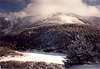
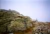
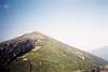
Mount Lafayette, located just east of I-93 (aka Franconia Notch Parkway) in Franconia Notch, is the highest peak in New Hampshire's White Mountains outside of the Presidential Range (6th highest overall). This is one of the most popular hiking peaks in the White Mountains because: (1) there is a popular 8.9 mile loop hike that is all class 1, (2) the summit is above treeline, (3) the mountain is right off of a major Interstate, and (4) as such, it is only about a 2 hour drive from Boston. This is as opposed to Mount Washington which can be class 2 near the top and often reached via the much slower NH SR-16 (about a 3 hour drive from Boston). On a clear day, you will have excellent views of Mount Washington and the Presidential Range looking east from the summit.
The most popular method of hiking Mount Lafayette is the Franconia Ridge Traverse that consists of a loop hike linking 4 class 1 trails and 3 summits (Lafayette, Mount Lincoln - 5089', and Little Haystack Mountain - 4780'). This itinerary starts and ends at Lafayette Place, the trailhead for the Old Bridle Path and Falling Waters Trails. Hiking north to south you would start at Lafayette Place (1780') and head up the Old Bridle Path reaching the Greenleaf Hut (4220') in 2.9 miles. From there continue east 1.1 miles on the Greenleaf Trail to the summit. Leaving the summit, travel south on the Franconia Ridge Trail 1.7 miles to Little Haystack Mountain (4780') and then west down the 3.2 mile Falling Waters Trail back to Lafayette Place. Total loop distance: 8.9 miles. This is popular both north to south and vice versa.
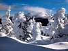
Hiking along the exposed Franconia Ridge between Lafayette and Little Haystack during the winter can be quite fun, however, be prepared for a lot of snow and consider bringing snowshoes (esp. Jan - Feb). Alternative routes include approaching from the Skookumchuck Trail and Walker Brook Ravine. Walker Brook Ravine is a YDS class 3 climb during the summer, an ice climb in early winter, and a snow climb during the winter.
 |
 |
 |
 |
 |
Getting There
LAFAYETTE PLACE TRAILHEAD (1780'): The Lafayette Place parking lot is the trailhead for the popular Old Bridle Path and Falling Waters Trails. This trailhead is located right off of I-93 near the northern end of Franconia Notch State Park. It is on the east side of I-93, north of "The Basin" and south of Profile Lake where you can see the Old Man of the Mountain. This is about a 2 hour drive from the Boston area and just north of Lincoln, NH.
GREENLEAF TRAILHEAD (1980'): This trailhead is also on I-93 and north of Lafayette Place. It is located at the Cannon Mountain Tramway parking lot on the west side of I-93.
 |
 |
 |
Red Tape
None if you are parking at trailheads in Franconia Notch State Park which include Lafayette Place and the Greenleaf Trailhead. The area around the summit includes areas in the Lafayette Brook Scenic Area (northwest), the White Mountain Nationa Forest (southwest) and the Pemigewasset Wilderness (east) so make sure you check the Camping Section if you wish to camp here.
When To Climb
Like many places in the NH White Mountains, you can climb this peak year round. Winter is an especially enjoyable to climb this peak as it is often overrun with hikers during the summer months.
 |
 |
 |
 |
 |
Camping
In general there is no need to camp on or near this peak. The two organized options are the seasonal AMC Greenleaf Hut at 4200' and the seasonal Lafayette Campground around 1780' across I-93 from Lafayette Place. You can call the campground at: (603) 823-9513. Although the Lafayette Campground isn't officially open during the winter it is possible to stay there. The AMC Greenleaf Hut area is a popular area for winter camping, even if the hut itself is closed.
If you don't mind camping farther away the Liberty Springs Tentsite to the south and the Garfield Ridge Tentsite to the north are also possibilities. To reach Liberty Springs Tentsite travel 1.9 miles south of Little Haystack on the Franconia Ridge and head west 0.3 miles on the Liberty Springs Trail. This site is run by the AMC and has a caretaker on site during the summer months. Ammenities include 8 large wooden tent platforms, a spring (which incidentally does not require any treatment), and a composting toilet. The current fee is $8 per person per night. The second option involves travelling north and then east along the Franconia Ridge Trail from the summit of Lafatette. In approximately 2.5 miles you will reach the summit of Mount Garfield. An additional half mile descent to the east will place you at the Garfield Ridge Tentsite. Facilities and charges at this site are similar to the Liberty Spring site with the addition of a covered shelter here. The spring located approximately 100 yards before the tentsite also contains potable water which does not require treatment. Be aware that both tentsites are frequently busy during summer weekends and are available on a first come/first serve basis. Thanks to Archangl for information on the Liberty Springs and Garfield Ridge Tentsites.
If you would like to camp in the backcountry, there are lots of Backcountry Camping Rules to be aware of.
Mountain Conditions
Use the following resources for weather conditions in the White Mountains:
MOUNT WASHINGTON OBSERVATORY: Higher Summits Forecast
FRANCONIA NOTCH STATE PARK
Franconia, NH 03580
Tel: 603-823-5563
PINKHAM NOTCH VISITOR CENTER
P.O. Box 298
(on NH SR-16 just south of Wildcat ski area)
Gorham, NH 03581
Tel: (603) 466-2721
Fax: (603) 466-3871
AMC Outdoors.org Website: Trail Conditions Message Board
Views From The Top: Current New Hampshire Trail Conditions
 |
 |
Miscellaneous Info
INTERESTING ARTICLES
A Natural Death by Rob Buchanan. On the life and death of Guy Waterman
External Links
- Mount Lafayette, Mount Lincoln and the Franconia Ridge
Discussion of routes, with distances and elevation gains. - Tragedy and tribute to accidental death on Mt. Lafayette
This article discribes one of the recent tragedies that happened on top of Mt. Lafayette. My prayer are out there for the family and I wish them well during this time of pain. - White Mountains Info Server
excellent site on the Whites of New Hampshire. Mountain and trail info, trip reports, tons of pics, hut/shelter info - basically everything you need to know about the White Mountains. - New Years Eve (2001)
STW - Apr 1, 2004 11:38 am - Hasn't voted
Untitled CommentText quoted from the Boston Globe:
Hiker says wrong turn in poor weather cost wife her life
By Theo Emery, Associated Press Writer, 3/29/2004
BOSTON -- Brenda and Russell Cox were married outdoors in the Vermont mountains seven years ago with a layer of new-fallen snow around them. Last Monday night, after the couple took shelter from a storm in a mountaintop cave in New Hampshire, Russell Cox reached for his wife, and felt that she had stopped shivering and her skin was cold. "Brenda died doing what she loved to do, and I think that that makes me happy," Cox said Monday at Massachusetts General Hospital, where he's been since rescuers found him last Tuesday outside the snowy cave where his wife died in the night.
Cox spoke to reporters Monday, a wedding photo propped on a nearby table, along with the New Hampshire Fish and Game official who led the search for the couple, the stepson who alerted authorities they were missing and Russell Cox's physician, Dr. John Schulz.
Schulz said Cox could stay in the hospital as long as two weeks, while doctors wait to see the extent of the frostbite damage to his toes, feet, chest and fingertips. "For Mr. Cox, it's still quite early. We're very encouraged by how his injuries have come along in the last few days, but it's quite early ... to make a prognosis for what the extent of tissue injury will be to his feet," Schulz said.
Under New Hampshire law, Russell Cox could be required to reimburse the state for the cost of the two-day search that eventually rescued him from the mountain ridge where he and his wife spent two nights last week, said New Hampshire Fish and Game Lt. Todd Bogardus. The state is looking into that possibility, he said.
Cox, 43, an engineer who designs computer chips for a North Shore company, spent the night of March 20 with his wife at a bed and breakfast before the two drove to Franconia the next morning, to the same trail they hiked about a year ago, he said.
"My wife and I have spent a number of weekends hiking in the White Mountains," he said. "We enjoy hiking in the winter: the trails are less crowded, the water is always fresh and cold, the scenery is always beautiful."
It was a roughly 10-mile loop to the summit of Mt. Lafayette, south along a ridge, over Mt. Lincoln and Little Haystack Mountain, and down Falling Waters Trail to the parking lot. The two had monitored the weather, brought food and were prepared for poor weather, he said.
They were on the Old Bridle Path by about 8:30 a.m. By about 11 a.m., they reached a hut part way up and met hikers who said the weather was turning sour. They decided to hike to the summit of Mt. Lafayette, then turn around, Russell Cox said.
After they reached the top, they turned around and began back down. But in the worsening weather, they chose the wrong trail, heading north. They strained to see the rock piles marking the trail through the whirling snow and wind.
The realized they had gone the wrong way when they reached a junction slightly less than a mile down the trail. By then, they could see almost nothing, their ski goggles frosted over and the 75 mph winds tearing at them.
They built a snow cave and spent a relatively comfortable night. But when they emerged early the next morning, the weather had barely improved, and as they continued down the trail that they hoped would bring them to the highway, their damp clothes froze on their bodies.
Unable to find their snow cave, they crawled into a rocky nook, lying back to back so that Russell Cox shielded Brenda Cox from the weather. They talked into the night, but in time, she fell silent, and her husband knew she was dead.
He crawled from the cave the next morning to find a brilliantly clear and warm morning. He managed to flag down the helicopter, which spotted him after several passes and airlifted him to safety, he said.
"I have the greatest memories of Brenda from the years we spent together, because we had a wonderful relationship," Cox said, fighting back tears. "Brenda and I loved each other very much, and I'm very happy that we were together at the end."
© Copyright 2004 Associated Press. All rights reserved. This material may not be published, broadcast, rewritten, or redistributed.
© Copyright 2004 The New York Times Company
DONT TAKE OUT "LITTLE" MOUNTAINS LIGHTLY. Mother Nature can kick your a** any time she wants.
nartreb - Apr 26, 2005 1:08 pm - Hasn't voted
Untitled CommentLafayette is not only the sixth-highest peak on the NH 4,000-footer list, it's the fourth most prominent peak in New England, according to the New England Fifty Finest List.