
-
 16410 Hits
-
 87.31% Score
-
 24 Votes
|
|
Mountain/Rock |
|---|---|
|
|
44.96710°N / 6.32960°E |
|
|
12352 ft / 3765 m |
|
|
Overview
geographical classification: Western Alps > High Dauphiné Alps > Grande Ruine
Grand Ruine has almost the height of Grossglockner but here in the High Dauphiné Alps it stands only in the second line behind the "big ones“ as Barre des Ecrins, Mont Pelvoux or La Meije.
But there are some advantages that speak for climbing Grand Ruine:
• the normal route is steep, but not difficult, only rated F, so it is the perfect mountain for starting climbs in this area to get an overview because Grand Ruine has a fine position in the middle of the main high Dauphine mountains
• the normal route is rather short, because the hut you take as basis – Refuge Adele Planchard (3173 m) - is already quite high
• the route to this hut is long but leads through a great, unspoiled nature, it is one of the most interesting routes to a mountain hut I know in the entire alps. The view from the hut is almost as wide as from a summit.
Grand Ruine is located half way on the chain that runs between Barre des Ecrins and Meije.
Grand Ruine is a mountain that consists of two summits:
• Pointe Breevort (3765 m), the main, south, summit
• Pic Maître (3726 m), the minor, north, summit
Both summits are devided by a gap called Brêche Giraud-Lézin (3666 m). Most parties only climb Pointe Breevort but Pic Maître is also worth visiting.
From Pic Maître a very rocky ridge starts to the east, that has Roche Méane (3712 m) as next mountain, separated by Col du Diable pass (3565 m).

 |  |  |  |  |
Getting There
Main access to the area is the main road that leads from Grenoble to Briancon crossing Col du Lautaret pass. West of the pass is famous ski resort La Grave and the first village east of it is Villar d’Arene.
If you choose to approach the mountain from its more difficult west side then La Berarde is your choice. You reach this little hamlet on a road that branches from the said main road shortly east of Bourg d’Oisans.
routes
I have only a German guidebook that does not list all climbing routes: So any help in this matter is appreciated!
to Pointe Breevort:
• East ridge, normal route; F; 2 h from Adele Planchard hut. My experience is that it is not difficult but steep in the upper part, so would rate it as PD; the glacier has many crevasses in the upper part
• South ridge; Fourastier, Keller; July 21st 1954; D-, UIAA IV (mostly III); 3 h from Col de la Casse Déserte
to Pic Maître
• South ridge, normal route: F, UIAA I. The guidebook tells to climb the rocky ridge from Brêche Giraud-Lézin. We found it better to climb in steep snow right of this ridge and reach the east ridge shortly before the summit. The rocks there were _very_ loose and we rated them with UIAA II
• West pillar and WNW-ridge; Brun, Thévenon, September 19-20th, 1964; UIAA VI (mostly IV and V), TD, 600m ascent; 10-14 h climb after 3 h approach from Châtelleret hut
to Col du Diable:
• north couloir; Miss Y. Millière, J.-P. Loustalot, L.Zwingenstein, July 23rd, 1923; ice 50° for 400 m ascent, D; best approach from Lac du Pave hut
 |  |
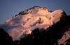
a morning on the normal route...
... rewarded us with some very fine mountain views:
 |  |  |  |  |
skiing
The High Dauphiné Alps are a paradise for experienced ski mountaineers and if avalanche conditions are good, great trips can be done. Grand Ruine is one of them. Climbing it is possible form east side via Adele Planchard hut or – more demanding – from west side from Chatelleret hut crossing Col de la Casse Déserte pass.
The approach to Adele Planchard hut is not done along the summer route (too steep and rocky in the lower section) but in a big curve from the backmost corner of the valley (Glacier de la Plate des Agneaux)
When To Climb
July to September in summer, April and May in spring with ski
Accomodation
Mainly the following hut serves as basis for the climb on the normal route:
• Refuge Adele Planchard (3173 m), 64 places (only 32 in winter), guided in summer season from end of June to mid September and in spring ski season from end of March to mid May. Though it seems to me that this hut is not often crowded, you should always phone in advance and make a reservation
5.5 h takes the ascent from Pied de la Colle (near la Grave – Villar d’Arene)


In addition there are these huts:
• Refuge de L’Alpe de Villar d’Arène (2077 m). Too low as basis for the climb but it can shorten the ascent to Adele Planchard hut. If you had a long journey, this is the recommendation for staying the first night in the mountain. The hut is in the middle of a spacious, green alpine landscape
• Refuge du Lac du Pave (2841 m); 4 h from Pied de la Colle; the hut is north of Grande Ruine, above the valley Clot des Cavales, and can support the ice route to Col du Diable
• Refuge du Châtelleret (2225 m). Basis for the steep west side of the mountain. 2 h from La Berarde.
Red Tape
Grand Ruine lies in the national park “Parc des Ecrins”. Climbing isn’t restricted at all, but you will not meet roads, cablecars and prepared ski runs in the heart of these mountains that fortunately are preserved for mountaineers.
As I have read it is prohibited
• to bring dogs into the park
• to use an open fire
• camping, but bivouacs are allowed as soon as you have walked at least 2 h inside the park
Mountain Conditions
The High Dauphiné mountains are the southernmost high elevation area of the alps. Weather is usually better than in other glacier regions of the alps, (even Pennine Alps), but it can be _very_ hot in the valleys (I speak from own experiences). So you should try to start early, also in order to avoid thunderstorms in the afternoon
Romanche river
The river Romanche is a quite important river in the French Alps. On your route to Adele Planchard hut you just follow this river upstream that shrinks to a nice mountain creek until you reach a site that is the “official” source. Hiking until there is a very popular daytrip.
 |  |  |  |  |
Maps and books
Best map is French map IGN Top 25 1:25.000 Nr. 3436 “Meije – Pelvoux”, available in shops in the area. Can be ordered in normal bookstores
German books that are my sources are:
• Guidebook “Dauphiné” by Hartmut Eberlein, Bergverlag Rother Munich 1988, ISBN3-7633-3414-9
• Ski guidebook „Westalpen“ by Reinhard Klappert, Verlag J. Berg ISBN 3-7634-1047-3
names / history
In this case names derive from the climbing history:
• Pointe Breevort has first been climbed on July 19th 1873 by Miss M. Breevort, together with W.A.B. Coolidge and lead by guides C. Almer, P. Michel, C. Roth and P. Bleuer - and not to forget the dog "Tschingel". Here you can see a picture of most of this party including the dog - scroll down, it is pic #5!
• First climb of Pic Maître has been done by J. Maître together with P. Gaspard and M. Bourbon on July 29th 1887.