
-
 86226 Hits
-
 95.07% Score
-
 51 Votes
|
|
Mountain/Rock |
|---|---|
|
|
37.56670°N / 105.4967°W |
|
|
Hiking, Mountaineering, Scrambling |
|
|
Spring, Summer, Fall, Winter |
|
|
14037 ft / 4278 m |
|
|
Overview
Little Bear is one of the crown jewels on the Colorado 14ers and being one of the harder 14ers to summit, receives quite a bit of attention. Located in the Sierra Blanca massif in the southern Sangre de Cristo Range, it is very prominent and rises over 6,000 feet above the San Luis Valley below. With the standard route encompassing some tough scrambling and a high level of objective danger due to rockfall, Little Bear Peak is often one of the last 14ers people climb on their way to topping out on all 53 of them. There are however, alternate routes that are both safer and more fun to climb. The standard approach follows the infamous Lake Como Road which is probably the toughest 4WD road in the state to drive up and most stock vehicles can only make it about halfway up before being forced to park. Despite being one of the harder 14ers, under the right conditions most parties will reach the summit but it's important each climber approach this peak with respect and exercise extreme caution when climbing through and above the Hourglass. A handful of excellent climbers have died here either from climbers above knocking rocks down or from large rocks breaking free. Taking objective danger alone, this peak is probably the most dangerous 14er via its standard west ridge route.
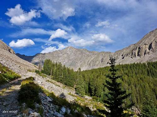 Little Bear Peak Little Bear Peak |
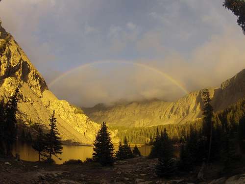 Lake Como Rainbow Lake Como Rainbow |
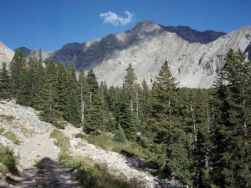 Little Bear Peak Little Bear Peak |
Getting There
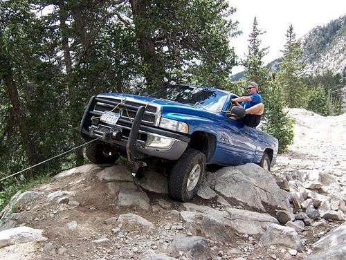
Alamosa and Fort Garland are the closest towns to the Lake Como trailhead. If you are coming from Denver, the fastest way to get here is to drive south on I-25 and take Exit 52 for the town of Walsenburg. Once in Walsenburg, follow the signs for US Highway 160 and turn right (west) onto 160. Drive this scenic highway over 9,450 foot La Veta pass which crosses the Sangre de Cristos between the Blanca massif and the Culebra group further south. Descend to Fort Garland and continue to the junction of U.S. 160 and U.S. 150 east of Alamosa. Turn north on U.S. 150 and go 3.2 miles to an unmarked dirt road leading northeast. Follow this dirt road northeast toward the Blanca massif for 1.8 miles to 8000 feet in elevation. It is strongly recommended that ALL passenger cars and 2 wheel drive vehicles park here. The road continues all the way to Lake Como, but parking along the road is difficult and limited. The Lake Como road is rough and the grade is steep with a lot of loose rock. Even stock 4WD vehicles typically park around halfway up as this road is probably the worst in the state. Hiking the 5 mile road is generally faster than driving it!
The first major obstacle you come across is roughly halfway just past a plaque that is engraved into one of the granite boulders next to the road. This is called Jaws 1 and will stop all but the modified 4WD vehicles. Shortly past this section is Jaws 2 and 3. Just walking these sections are trouble enough!
 Start of the Lake Como Road Start of the Lake Como Road |
 Jaws 2 I believe Jaws 2 I believe |
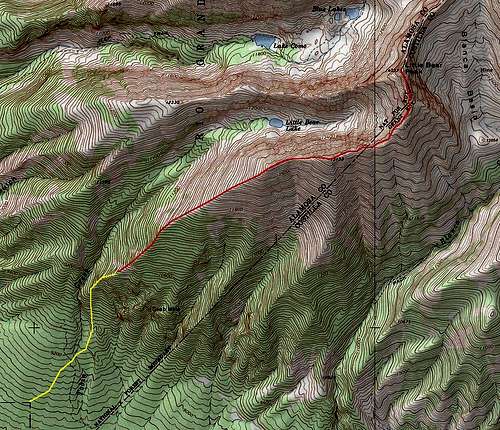
Standard Lake Como Approach
This is the standard and most popular approach to Little Bear Peak. Park at 8,000 feet right when the road becomes significantly rougher. The road to Lake Como is 5 miles and gains 3,740 feet making this one of Colorado's lowest trailheads and can be extremely hot and uncomfortable in the summer months. The steep road climbs along Chokecherry Canyon and then angles northeast into Holbrook Creek which is then followed to reach the outlet of Lake Como. There is only one place to get water along the entire approach and that's where the road crosses to the north side of Holbrook Creek. Above that, the road rests well above the creek and access to it is difficult. Upon reaching Lake Como hike around the north end of the Lake for 0.2 miles to some camping spots on a bench above the lake at 11,900 feet. The land on the south end of the lake is private property. Near the outlet on the west side of the lake there is an old cabin and excellent camping there too. From the 11,900 foot bench Little Bear is less than a mile east and it's northwest face is the most prominent view.
 Driving the Lake Como Road Driving the Lake Como Road |
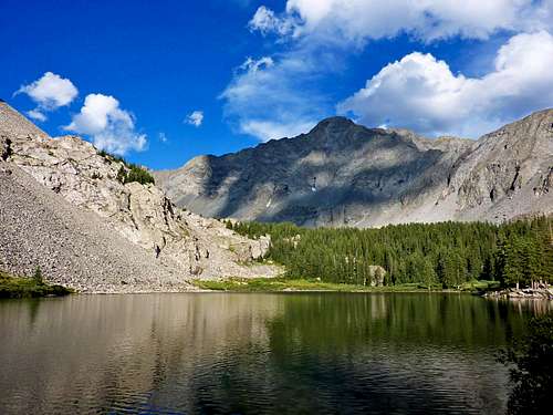 Little Bear seen from Lake Como Little Bear seen from Lake Como |
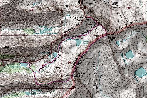
 Lake Como Approach Map Lake Como Approach Map |
Route Options
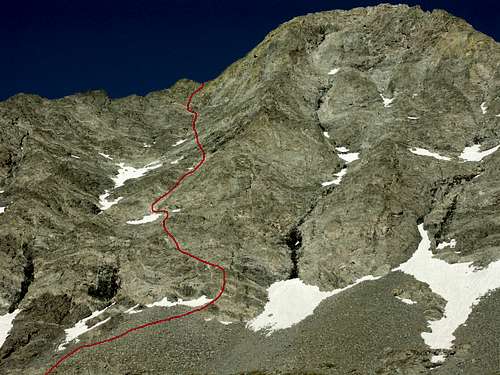
Standard West Ridge/Hourglass Gully - Class 4 - (Mountain Project Description)
RT Distance from Lake Como - 3.5 Miles
RT Distance from 2WD Trailhead - 14 Miles
 Start of the standard route Start of the standard route |
 Looking up the Hourglass Looking up the Hourglass |
 Standard Route Map Standard Route Map |
The link above will take you to the fantastic route page by RyanS here on Summit Post. This route starts using the informal Tobin Creek Trailhead which is on private property. A series of dirt roads that may have been originally made for a housing development that never happened are found on the lower southeast slopes of Little Bear Peak. The idea is to get to the furthest northeast corner of this set of roads and park. A half mile south of the Lake Como Road on Highway 150, turn right (east) onto a good road (18th Street) which then turns northeast and turns into Grant Avenue and follows the border of Alamosa and Costilla counties. It then turns north, turns into Finton Avenue, and rapidly deteriorates before reaching a 90 degree turn back to the left at an elevation of 8,830 feet. Either get permission from the landowner (which won't happen) or be discrete.
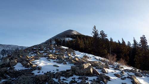
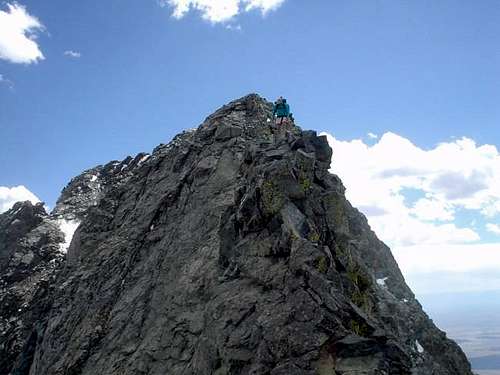
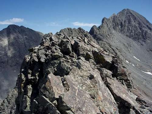
Park here and begin the route by routefinding your way through juniper bushes and small trees in a northeast direction. Cross Tobin Creek before it turns into a deep gorge higher up and mount the southwest ridge of Little Bear. The ridge is quite pleasant below treeline but at 11,900 you break above the last trees and the broad ridge steepens until reaching a small false summit at 12,900 feet. At this point the terrain down to your left (north) becomes much rougher and the ridge becomes much flatter, heading up and over three more tiny peaks before making the final steep push to South Little Bear. A couple short knife edge spots are found along the way spicing it up a bit (Class 4).
Once on South Little Bear, the route drops to the north and a half-mile long traverse (Mamma Bear Traverse) brings you to the true summit of Little Bear. Most of the difficulties can be bypassed on the left (west) side of the crest but there are a couple spots you must cross or stay on the very narrow and exposed crest. Just before the summit you will cross the saddle the standard route climbs to above the Hourglass.
RT Distance from Tobin Creek TH - 8 Miles
 Reaching treeline on the SW Ridge Reaching treeline on the SW Ridge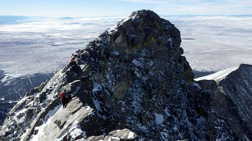 Knife edge section of the SW Ridge Knife edge section of the SW Ridge |
 South Little Bear and the Mamma Bear Traverse South Little Bear and the Mamma Bear Traverse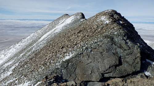 False peaks on the SW Ridge False peaks on the SW Ridge |
 Southwest Ridge route map Southwest Ridge route map |
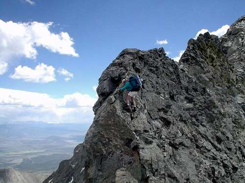
This route is a fun alternative to the Hourglass gully. It involves some tougher climbing over slightly more solid rock. Using the same start to the standard route as described above, reach the west ridge and hike along the ridge to the notch. Instead of leaving the ridge and traversing right onto the southwest face, continue directly up the crest of the ridge and stay on it for nearly the entire climb. There are a couple towers and headwalls to negociate and the two crux sections include a 5.4 chimney with a large chockstone guarding the top, followed by a 5.2 slab. Once near the summit, the terrain eases and you'll locate some cairns and scramble the remainder of the way to the summit.
RT Distance from Lake Como - 3.4 Miles
RT Distance from 2WD Trailhead - 14 Miles
Northwest Face - Class 4 - (Mountain Project Description)
This climb is much less traveled than the Hourglass gully standard route on Little Bear. It ascends the impressive northwest face of Little Bear and connects with the Little Bear to Blanca ridge near the summit. Most of the work is picking your way through the 3rd class talus and scree at a fairly high angle. Two points on the route may require the use of pro which include gaining the shelf above the "Black Hand" on the rock and gaining the ridge close to the summit. People have reported being able to pass the "black hand" to climbers right while keeping it 4th class.
Once you've passed the Black Hand, follow the steep 3rd class gullies up to a more level area and head up and right to a weakness in the ridge. You may want to simul-climb to the top of the ridge, continuing to the summit. - Paraphrased from Mountain Project
 Low on Little Bear's NW Face Low on Little Bear's NW Face |
 The NW Face route of Little Bear in June 2004 The NW Face route of Little Bear in June 2004 The Black Hand can be seen just to the right of the lower tree in the left of the picture. Start the route there. The Black Hand can be seen just to the right of the lower tree in the left of the picture. Start the route there. |
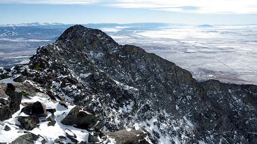
Little Bear to Blanca Peak Traverse - Class 4 - (Mountain Project Description)
"Walk off LB's summit to the NE about 150ft. Traverse back towards the ridge to gain a large flat slab. Down climb this another 150ft. That is the crux. The rock is good and there are holds but it is steep and falls away sharply. Continue along the ridge through blocky sections, knife edge sections and ridge top sections until you reach Captain Bivouaco Tower. Climb this direct, a couple of 5.5 moves, or move around it on its' North side. This move requires you to step around a bulge and down onto suspect rock, but with good hand holds and a long step down it is easy to move around the bulge to solid ground.
Moving beyond the tower you begin gaining elevation to a long isolated section of ridge with multiple high points. It looks like the ridge on the back of a Stegosaurus. Good rock, some scrambling, lots of exposure, great views, a good place to grab a snack, some water and take photos. Beyond the dinosaur ridge is the Gendarme. This is what I refer to as tower 1 because from Little Bear the last three obstacles to Blanca's summit appear distinctly as Tower 1, 2 & 3. I think officially Tower 1 is called the Gendarme and Tower 2 is called point 13,900'. As you confront the Gendarme you quickly realize that it is tall, steep, and consists of very poor rock. However there is a crack system up it and possible lines of ascent using trad gear in one pitch. Without gear it is best to scramble around it to the South through the scree. This scramble forces an elevation loss of about 200' or more.
Beyond the Gendarme you enter the saddle between Blanca and Little Bear. This is where you could easily escape to the South down scree slopes. With the Gendarme behind you gain the ridge again and follow it up and over T2 where there is a long section of undulating knife edge ridge consisting of good rock. This again drops you into a saddle at the base of T3. Ascend T3's broad slope up slabs to blocky rock and beyond it's summit after one more 20 meter section of knife edge you are deposited onto Blanca's upper summit slope." - sunnysummit
One Way Distance from Little Bear Peak to Blanca Peak - 1.5 miles
 Little Bear to Blanca Traverse Little Bear to Blanca Traverse |
 Little Bear to Blanca Traverse Little Bear to Blanca Traverse |
 Little Bear / Blanca Traverse Little Bear / Blanca Traverse |
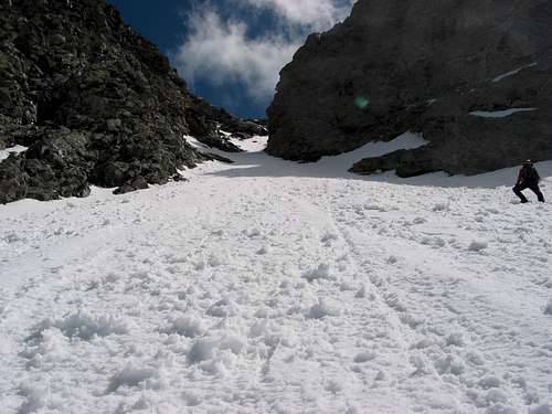
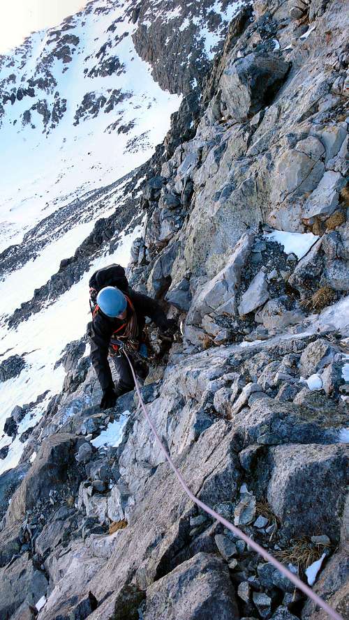
The Hour Glass
The hourglass is much talked about and rightly so. Little Bear is a dangerous mountain even under ideal conditions. The list is long of accidents and deaths on this peak. At a minimum a helmut should be worn through the hourglass and upper sections of the mountain. Rocks and debris from the upper mountain funnel directly into the Hourglass. In general, the best climbing conditions are during the summer months. Snow may remain on the north-facing slopes until the beginning of August. Rain, sleet, and snow can turn climbing into an unforeseen adventure. Asses the weather conditions constantly while climbing Little Bear Peak. During the spring, the hourglass and the talus slopes above are covered with consolidated, solid snow and is usually a safer time to make the ascent if you are competent with an ice axe and crampons. Here is a short video and photos of someone climbing the crux in the Hourglass.
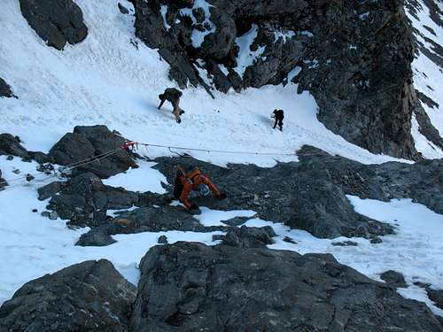 Looking down into the Hourglass Looking down into the Hourglass |
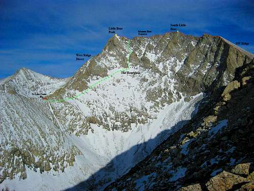 Little Bear Routes Overview Little Bear Routes Overview |
Camping/Red Tape
There are camping spots all the way up the Como Lake jeep road. A high camp above Lake Como on the benches is recommended and many people camp near the old cabin on the west side of Lake Como. Excellent camping can also be found at Blue Lakes but you are above treeline here and exposed to more wind. There are rumors also that a few people live at the 8,000 foot trailhead in campers and such but the camping here is also decent.
The Sierra Blanca area is littered with private property. The entire south and east flanks of Little Bear are on private property which includes all of Blanca Basin and much of the SW Ridge. The south side of Lake Como is also on private property and it's advised you avoid that part of the lake. Either ask for permission if you want to cross private land or be discrete.
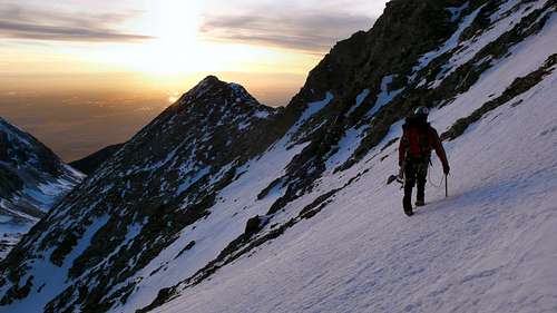 Heading for Little Bear's West Ridge at Sunset
When to Climb
Little Bear Peak is best climbed from June through September however it can be climbed at any time of year. In winter, the SW ridge is a great option as it keeps you out of any avalanche terrain. Many people avoid the rockfall dangers on the standard route by climbing it in spring when the route is covered in firm snow. Beware that afternoon thunderstorms are particularly violent in the Sangres and can last well into the night. Plan to be off the summit and ridges before noon. The Sangres typically get less snow than other ranges in Colorado and will typically melt out faster making the climbing here a little more enjoyable.
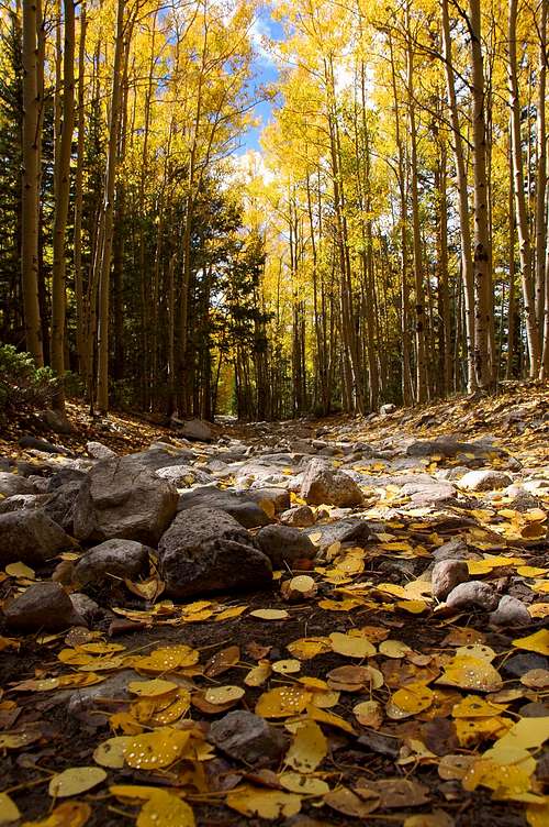 Fall colors on the Lake Como Road Fall colors on the Lake Como Road |
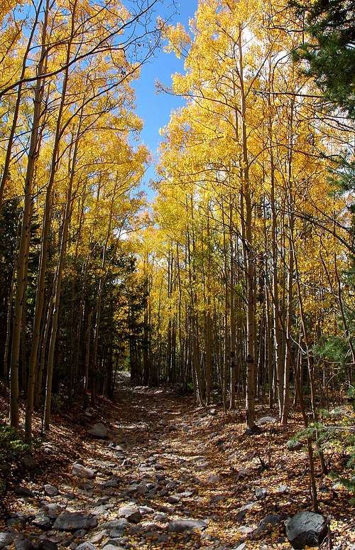 Fall colors on the Lake Como Road Fall colors on the Lake Como Road |
The Blanca Slam
Many adventurous souls try for the Grand Slam covering all three 14ers in the group (Little Bear, Blanca, and Ellingwood) in one long day from a camp at or above Lake Como. It is best to attempt the traverse from Little Bear to Blanca first. This puts one off the ridge sooner rather than later and the risk of getting caught in a deadly storm can be mitigated. Starting the traverse to Blanca is a big commitment. You should assess the weather conditions and your energy reserves before making the attempt. The traverse from Blanca to Ellingwood Point is both shorter and less technical. One can also opt out at the Blanca/Ellingwood saddle and head for lower ground if the weather moves in.
 Grand Slam Blanca Trifecta Map
External Links
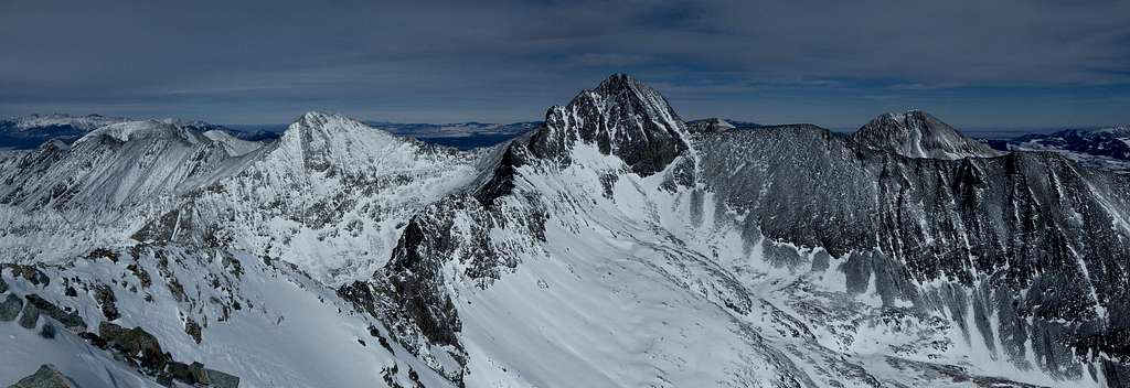
Little Bear Summit Panorama with Blanca Peak in the center
Standard West Ridge Trip Report
West Ridge Direct (5.4) Trip Report
Little Bear on Mountain Project