
-
 72716 Hits
-
 94.82% Score
-
 49 Votes
|
|
Mountain/Rock |
|---|---|
|
|
46.06253°N / 7.86304°E |
|
|
Wallis |
|
|
Mountaineering, Ice Climbing, Mixed |
|
|
Spring, Summer |
|
|
13799 ft / 4206 m |
|
|
Overview
Geographical classification: Western Alps > Pennine Alps > Mischabel Group >Alphubel
Alphubel 4206 m
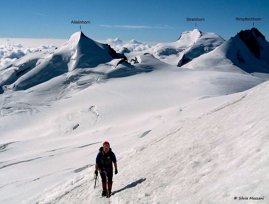
Alphubel 4206 m is a large and massive icy peak belonging to the golden circus of the 4000s of the Mischabel Group in the Wallis (Swiss Alps) and showing a characteristic shape of a trapezium. Check here the complete list of the 82 alpine Fourthousanders and the 46 minor summits: Club4000.
This superb mountain lies in a majestic icy environment between the Mischabeljoch 3851 m, which separates Alphubel and Täschhorn, and the Alphubeljoch 3782 m, a wide icy saddle which separates Alphubel and Feekopf; its squared bulk and flat top make it unique if compared to the jagged mountains that surround it. East and West sides have totally different characters: on the East, towards Sass Fee, the glaciers go up to the summit and build a summit plateau having a length of almost 1 km from the South to the North. On the West, towards Täschtal (Täsch Valley) the mountain looks mostly rocky, with a severe wall dropping steeply down to the Weingartenglacier.
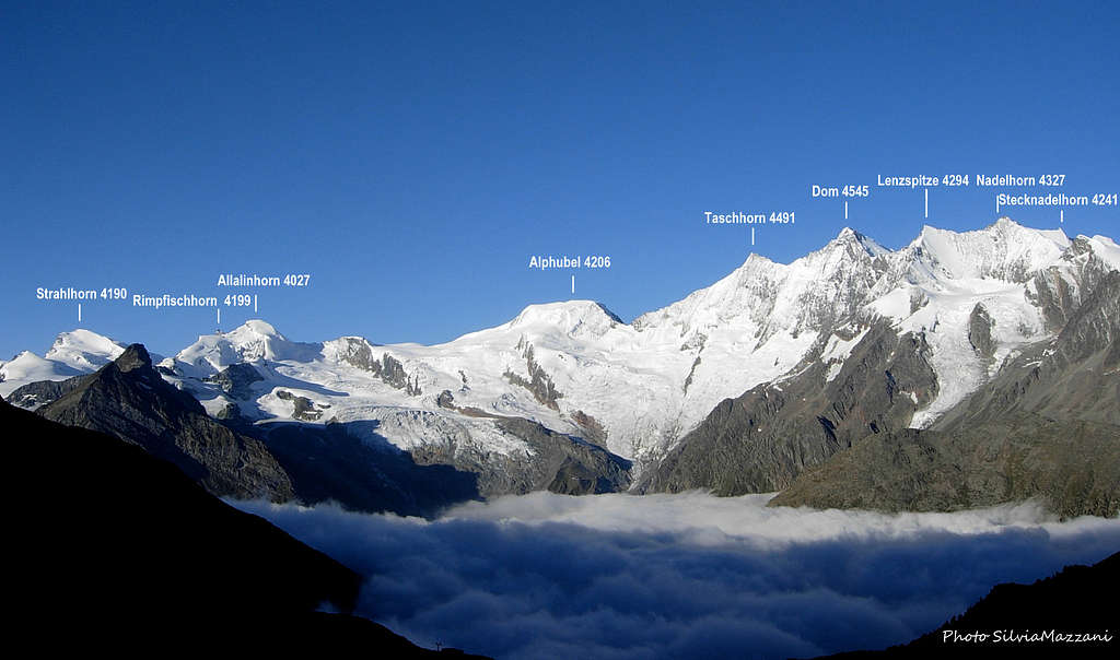
From the Alphubel you have a very nice view over the Mischabelgroup and across to the Matterhorn and Monte Rosa. If there is fog, it is difficult to find exactly the highest point (marked by a wooden cross), because the summit plateau is substantially flat.
The route of the first summiters who climbed the mountain from Täsch on the West side is not the current normal route. Alphubel is very popular amongst ski-mountaineers and is usually accessed from Längflue. In summer I would suggest to climb Allalin early in the morning and then attach the Alphubel via Feekopf.


If you are on a vacation, continue to the Alphubeljoch, stay at the Alphubeljoch bivouac, where it starts the chain of Mischabels, and try Täschhorn and Dom next day and stay overnight at the Dom hut. For the Routes compare the section Routes-Overview below.
Climbing history

- The first summiters were the British T.H. Hinchliff and Leslie Stephen with Melchior Anderegg and Peter Parren in 1860, August 9th and started from Täsch.
- From the East side, the Alphubel was first climbed only 22 years later by H. Dubi, K. Munzinger and A. Supersaxo in 1822, July 29th, but it is possible that the mountain had been climbed earlier by unknown climbers. The reason was probably that the Alphubel was more famous for the people of the Matter Valley than those of the Saaser Valley.
- The Rotgrat was climbed for the first time in 1889 (by George Broke with Adolf and Xavier Andenmatten).
- The first ascent with skis was on the 29th March 1910 from Saas Fee. Dr. Alfred von Martin and Hermann Rumpelt together with the guide Oskar Supersaxo from Saas Fee needed 9 h in order to reach the Alphubeljoch.
Getting There
1. To climb the Alphubel:
a. You can either start from Längflue (2869m)
b. or from the Täschhütte (2701 m)
c. or from the Mischabeljoch-Biwak (3851 m)

The starting point is the ski and mountaineering station of Saas Fee m. 1803 (cars are not allowed in the village, parking place just outside the village), situated in Saastal, which is reached from the town of Visp (Rhone valley) by car or bus. You reach Visp by car or train:
a. from the West: From Geneva (airport) by train or on the autobahn via Lausanne- Montreux-Sion-Visp.
b. from the North: from Interlaken by train or car to Spiez, from here the road to Brig - Visp by train or by car to Kandersteg, load the car on train, pass the Loetschberg tunnel to Goppenstein and head for Visp. From farther north drive via Bern on route c.
c. from the East: from Bregenz on the autobahn to Zürich, Bern, Fribourg, Vevey to Visp. Hourly train connection. d. from the South: either from Bellinzona to Airolo, turn left before entering the Gotthard tunnel, drive over the Nufenen pass road to Brig-Visp. From Milan take the Simplon pass to reach Brig - Visp. Dirct trains to Brig from Milan.
- From the town of Visp in Rhone Valley (Wallis) take the Vispertal and follow it to Stalden m. 799. Pass Stalden and get a road junction. Turn to left, entering the Saastal and getting Saas Balen m. 1483 and Saas Grund m. 1559. On the right follow a road getting within 4 km. to the nice village of Saas Fee m. 1803 (30 km. from Visp).


Approach to Längflue
There are two different ways:
- By walking (3,30 hours from the village). From the church of Sass Fee m. 1772 a narrow road leads to Hinter den Zäunen; from here cross the river and through the fine forest of larch trees get a small lake m. 1904, just beneath the huge moraine of Feegletscher. The good path rises up the moraine getting to Spielboden m. 2447, the middle station of the cable-car. Up the rocky slopes of Längflue to the hut.
- By cable-car from Saas Fee to Längflue. From the car-park cross the village towards South for about 1 km., getting the hamlet of Kalbermatten, starting point of the cable-car. The first section of the cable-car leads to the Spielboden middle Station 2448 m. From here take the second section to the upper station close to the hut. Check here the timetables: Sass Fee cableways

Starting point is Täsch. Täsch is accessed from Visp by train or car (parking fee!) Reach the Täschalp on a small road from Täsch via Täschberg. From there to the hut from Täschalp (Ottavan) in 1 1/4 h, 490 hm. You go on a wide way, at first a few meters along the Rotbach, and then zigzag through the hangs western below the Rotridge. You traverse below the hut and reach it from the E. This is also the winter ascent. Danger of avalanches above the Täschalp!
3. Mischabeljoch-Biwak (3851 m)
The route to the bivouac is the same route to Mischabeljoch. A full day from Täsch, 4 hours from Längflue. Lots of crevasses. Usually used as a connection between the Allalin group and the Mischabel group.
Alphubel main routes overview
Alphubel main routes overview


1. East Flank Normal Route from Längflue
This is the Normal and ski-mountaneering route. The itinerary is fairly easy and usually there are tracks, but we must pay attention to the crevasses. At first the ruote heads in the direction to Albhubelhjoch, then either straight up (35°) to 4206 m (summer) or to the right 4125 m (ski). Alpine F+, difference in level from Längflue 1300 m., 4 hours
This is the Normal and ski-mountaneering route. The itinerary is fairly easy and usually there are tracks, but we must pay many attention to the crevasses.

At first the ruote heads in the direction to Albhubelhjoch, then either straight up (35°) to 4206 m (summer) or to the right 4125 m (ski).
Alpine F+, difference in level from Längflue 1300 m., 4 hours
2. SE-ridge from the Alphubeljoch This is the ascent of the first climbers in 1860. Leave pt. 3904 to your left. 2 hours from Alphubeljoch. More interesting than 1. Alpine PD, Max 40°


3. North Ridge from Mischabeljoch The route follows the ridge, at first on rock, then on snow. Alpine AD-, difference in level from the col 350 m, 1.5 hours.

4. W-ridge (Rotgrat) from Täschhütte Interesting mixed tour. From hut keep north to saddle 3141 of the Weissgrat. Descent, then leave the path and head for 3637 on the Rotgrat and follow it to the top. Alpine AD, III+, the difficulty is mainly on rock, difference in level from Täschhütte 1500 m., 6 hours


5. W-ridge (to the North-summit, 4116 m): From Täschhütte (or Täschalp) towards Mischabeljoch to pt. 3219 above the small lake. Start the ridge. At 3800m climb around the gendarme on the south side. Alpine D, IV+ on rock, 9 hours. Excellent climb on good rock, wild setting.
Essential gear

")
Summer: rope, axe, crampons, full glacier gear
Spring: rope, axe, avalanche detector, shovel
Red Tape
Car are not allowed in Sass Fee and must be left in the paying car-park at the entrance of the village. No others particular restrictions in mountaineering, climbing and hiking.
Huts and other accomodation

Längflue hut lies just below the Alphubel at the start of Feegletscher.
- 130 beds (20 winter) - serviced almost all year round.

The Täschhütte is situated highly above the valley of the Täschalp, a little bit on the southern side at the foot of the Alphubel-Rotgrat (SW ridge). From this place, you have a wonderful view to the Weisshorn. It is a good starting point to climb any summit between Täschhorn and Rimpfischhorn.
- 65 beds http://www.taeschhuette.ch/huette/ - winter room with 16 beds - serviced from May to October - phone: ++41(0)27 967 39 13
3. Mischabeljoch-Biwak (3851 m), 24 beds
Route to the bivouac is the route to Mischabeljoch. A full day from Täsch, 4 hours from Längflue. Lots of crevasses.
- There is a camping ground in Saas Grund
When To Climb
Mountaineering: usually the best period goes frome middle June to middle September, with the notice that in late summer the glacier is highly crevassed.
Ski-Mountaineering: from March to May
Views of Alphubel
 |
 |
 |
 |
 & the green Kreuzboden Lake") |
 |
Guidebooks and maps
Guidebooks


 Guidebook")

"Il grande libro dei 4000 - Vie normali e classiche" by Marco Romelli, Valentino Cividini - Idea Montagna Editore, 2015
"Tutti i 4000” – L’aria sottile dell’alta quota" - CLUB 4000 CAI TORINO – Vivalda Editori
"The 4000 of the Alps" by Richard Goedeke (CAAI) – All the normal routes to the 4000m. summits of the Alps – Libris Edition.
"Monte Rosa" by Gino Buscaini - Collana Guide dei Monti d'Italia CAI-TCI (Club Alpino Italiano-Touring Club Italiano)
"I Quattromila delle Alpi" by Karl Blodig and Helmut Dumler – Zanichelli Editore
"Walliser Alpen, Vol. 5: vom Strahlhorn zum Simplon" - Verlag Swiss Alpine Club (German or French)
"Ski alpin, vol. 3: Alpes Valaisannes" - Verlag Swiss Alpine Club.
Maps "Randa" n. 1238 - 1:25.000 "Matterhorn-Mischabel" n. 5006 - 1:50.000 "Mischabel" n. 5006S (with ski-routes and difficulties) - 1:50.000.
See the Swisstopo Map with many interesting features. Upload is in a seperate window.
Meteo
Other Literature
- Helmut Dumler/Willi P. Burkhardt, Viertausender der Alpen. 11th ed. Munich 1998. ISBN 3-7633-7427-2
- Michel Vaucher, Walliser Alpen. Die 100 schönsten Touren. 2nd ed. Munich 1990. ISBN 3-7654-2124-3
- Michael Waeber, Walliser Alpen. DAV-Gebietsführer. 12th ed. Munich 1999. ISBN 3-7633-2416-X
- Hermann Biner, Hochtouren im Wallis. Vom Trient zum Nufenenpass. 2nd ed. 1996. ISBN 3-859022-160-5
External Links
Alphubel at www.4000er.de Images, routes, coordinates and more information about the highest peaks of the Alps