
|
|
Mountain/Rock |
|---|---|
|
|
48.16250°N / 120.8078°W |
|
|
9249 ft / 2819 m |
|
|
Overview
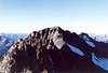
Long in coming and yet always worthy: Mt. Fernow is the king of the Entiat, and yet until now (April 6, 2004) only its subordinates have been written up on this site (The Queen of Maudes, The Jack of Seven Fingers who is always coming between them, and the metal they're probably fighting over: Copper). Okay, so that analogy was a stretch. Not only is Fernow king of the Entiat but, at 9,249 ft, it is also one of the Lords of Washington, it being among the highest mountains in the state. I had to put an end to this inequity. So I present to you Mt. Fernow.
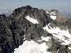
Mt. Fernow is about 150 feet higher than Maude and Seven Fingered Jack. It lies between Seven Fingered and Copper at the converging heads of the Entiat River on the east, Copper Creek on the northeast, and Big Creek on the west. The mountain is distinctly alpine yet due to its position east of the crest has little in the way of glaciers. A few small glaciers occupy the Maude-7FJ-Fernow Cirque. There is another small glacier in the Copper Creek drainage east of the peak and yet another on the north side of the peak, but mostly they're much reduced from earlier times (and dying a slow global warming death).
The mountain offers technical climbing but it is mostly sought as a scramble peak. It can be climbed in a day from Holden Village (which itself requires a day to get to) or possibly from the Phelps Creek Trailhead, but most of the time the mountain requires an overnighter. Yes, why be in a hurry in this beautiful region? Because it seems to be the trend in mountaineering: go fast and light and get back home in time Sunday evening to tuck the kids in for the night.
 |
 |
Getting There
There are three general approaches to this peak: (1) Phelps Creek, (2) Holden Village, and (3) Entiat Meadows. The shortest drive and approach for these is for Phelps Creek. Access to Holden Village can only really be had by taking The Lady of the Lake ferry up Lake Chelan. The approach to Entiat Meadows is 15+ miles of mostly flat trail. The meadows are reportedly quite beautiful but they're quite a schlep to get to (though on horseback it would be gentler, except for the saddle chaffing your arse).
 |
Phelps Creek Approach & Climb
For directions to the Phelps Creek Trailhead, let me once again (third and last time) shamelessly quote Bob from his Mt. Maude page: "For the Chiwawa River / Phelps Creek / Leroy Creek approach, drive east from Stevens Pass or west from Leavenworth on US Highway 2 and turn north toward Lake Wenatchee [at Coles Corner]. After the Wenatchee River bridge go right at a Y, then drive 1.1 miles on county road 22 and turn left on Chiwawa River forest road number 62. Drive 24 miles to near the end of the road [if you get to Trinity camp, you've gone too far] and turn right on the Phelps Creek road. Drive to the end of this road to the trailhead." The trailhead is at 3,500 ft.
Hike the easy Phelps Creek Trail for 3.5 miles or so to its crossing of Leroy Creek (c. 4,120 ft). Find the well-worn climber's path up the north side of the creek. The path leads up and up steeply then levels off to reach Leroy Creek Basin. There is a large meadow at 6,100 ft about one mile southwest of Seven Fingered Jack that offers good camping and water (maybe four hours to get here from the trailhead with heavy packs). Alternatively, it is possible to climb Fernow in a day from a large camp on the Phelps Creek Trail about a quarter-mile before Leroy Creek is crossed. This avoids the long haul of overnight gear up the hillside, but it's nowhere near as scenic a camp spot.
From the basin at 6,100 ft, climb NNE up the obvious drainage coming down from the west side of Seven Fingered Jack. Continue up to the saddle at ~7,760 ft on the West Ridge 7FJ. From this saddle you will get your first glimpse of Fernow peeking above the long North Ridge of 7FJ. Oh joy, time to lose elevation. It is now required that you descend perhaps 1,000 ft into the head of Big Creek. There is a glacier and a moraine shown on maps but these are not an issue. Crevassing is minimal and avoidable (more like ice sheets) and the moraine is below where you will be traversing. The trick is getting into the basin from the saddle. Some have reported it as being Class 4 but I would rate it as slabby Class 3 (I climbed Fernow in August 1996). I can't remember if I used crampons once I got off rock and onto a snow finger.
You can essentially see where you need to go. You need to cross under the glacier remnant and aim for the broad valley/couloir on the southwest side of Fernow. There are some minor cliffs to negotiate lower down but you can generally see what you need to do (not sure if this would be the case in a whiteout). Continue up the shallow couloir (probably snow-filled) to the ~8,700-ft col immediately south of the peak. I then finished the climb by climbing up and around the east side in a counterclockwise manner (Class 3). Basically, pick the easiest route for you. There may be routes up the southwest face. Expect rocky ribs and loose gullies.
 |
 |
 |
 |
 |
Climb 1 from Holden Village (Copper Creek)
From Holden village, hike west a few hundred yards to the trail (road) that crosses the creek to the mine ruins SW of town. (From the campground, hike east to the trail across the creek.) Where the road makes a turn to the east below the old concentrator ruins, follow a road east. The road crosses Copper Creek. In another 0.25 miles on top of the big, flat tailings pile, the Copper Creek Trail junctions off (3,320 ft). There may be a sign for this trail. The trail climbs steeply up the hillside for about 0.7 miles before entering the Copper Creek drainage whereupon it parallels the creek southward. Maps show the trail ending at 4,750 ft. From trail's end take the path of least resistance up talus (and some swampy ground if you should run into it) to the 7,200-ft Copper-Entiat Divide between Mt. Fernow and Buckskin Mountain. Cross the divide then turn west and climb up the East Ridge of Fernow generally staying on the talus slopes of the south side for approximately one mile to the summit. Some minor rock sections should be expected. Class 3.
 |
 |
Climb 2 from Holden (North Face -- Ice Climb)
This is apparently a suitable ice climb but you may be able to avoid ice altogether. See Beckey's Cascade Alpine Guide for more info. Access to this side of the mountain is via Big Creek. To get to Big Creek from Holden Village, hike up the Railroad Creek Trail 1.5 miles (to 0.5 miles west of the campground) to where Big Creek joins Railroad Creek. Leave the trail, ford Railroad Creek, and head into Big Creek's drainage. There may be game trails or a minor climber's trail. There is no designated trail in this valley. The first mile to 4,100 ft should be in forest. At 4,500 ft near the creek there is apparently a good camp spot. At ~4,600 ft, leave Big Creek and hoof it southeast up the long drainage coming off the north side of Fernow. After about 3,200 ft of climbing in 1.2 miles you will reach a glacier. The glacier curves to the right to reach up into the cirque below the North Face. The upper part of the ice apron trends toward 45 degrees. A feasible finish is to trend right toward the West Ridge then complete the climb on that ridge. 6 hours from timberline?
 |
Entiat Approach & Climb
To get to the Entiat River Trail, exit Alt.US-97 just south of the town of Entiat on the west side of the Columbia River and take the Entiat River Road northwestward. Keep on the road (paved for most of the way) for 38 miles to its end just past Cottonwood Camp. Elevation = 3,140 ft.
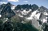
Hike the Entiat River Trail for 14-15 miles (a good camp is located at 14 miles). The trail begins turning from north to west at about 11 miles (c. 4,700 ft). The meadows actually extend for a long way in this east-west section of valley. Eventually, the meadows give way to talus and morainal debris where the trail ends. The upper valley is comprised of cirques within cirques. Above you will loom, left to right, Mt. Maude, Seven Fingered Jack, and Mt. Fernow. Additionally Buckskin Mountain rises up from the north side of the valley. A climber's path leads up to the 7,200-ft saddle between Fernow and Buckskin. Take this trail (if you find it) toward the saddle then complete the climb on the south side of the East Ridge of Fernow. Some rock steps should be expected (Class 3). If you can't find the trail to the saddle, from 5,400 ft in the valley, simply pick the path of least resistance WNW toward Fernow's summit (minor cliff bands and gullies will confront you). Perhaps 4 hours from the upper meadows.
 |
Red Tape
This peak resides in the Glacier Peak Wilderness, therefore the "leave no trace" policies, etc. apply here. There would probably also be a Trail Park Pass requirement for the Phelps Creek and Entiat River trailheads.
When To Climb
Spring to fall. It is possible to get to Holden in winter. From there a good ski tour to the summit can be made up Copper Creek (provided avalanche conditions are at a minimum).
 |
Camping
Most of the terrain is fairly open, meaning you could camp just about anywhere. But for the sake of erosion, it is best to select unvegetated ground. For the Phelps Creek approach, there is a camp on the Phelps Creek Trail about a quarter-mile before the Leroy Creek crossing. Also, camping is good at 6,100 ft in Leroy Creek Basin. For the Copper Creek approach, good camping can be found on the trail at about 5,400 ft but Fernow can be climbed from Holden in a day. For the Entiat approach, there are plenty of campsites along the trail (e.g., at 8.5 miles at the Ice Creek Trail junction there is a good one).
Mountain Conditions
Localized Forecast
Stehekin weather (the nearest town with weather info)
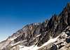
Views from the Mountain I
 |
 |
 |
 |
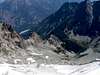
Views from the Mountain II
 |
 |
 |
 |