
-
 24116 Hits
-
 92.04% Score
-
 37 Votes
|
|
Mountain/Rock |
|---|---|
|
|
37.89950°N / 107.5126°W |
|
|
13806 ft / 4208 m |
|
|
"American Peak" Overview
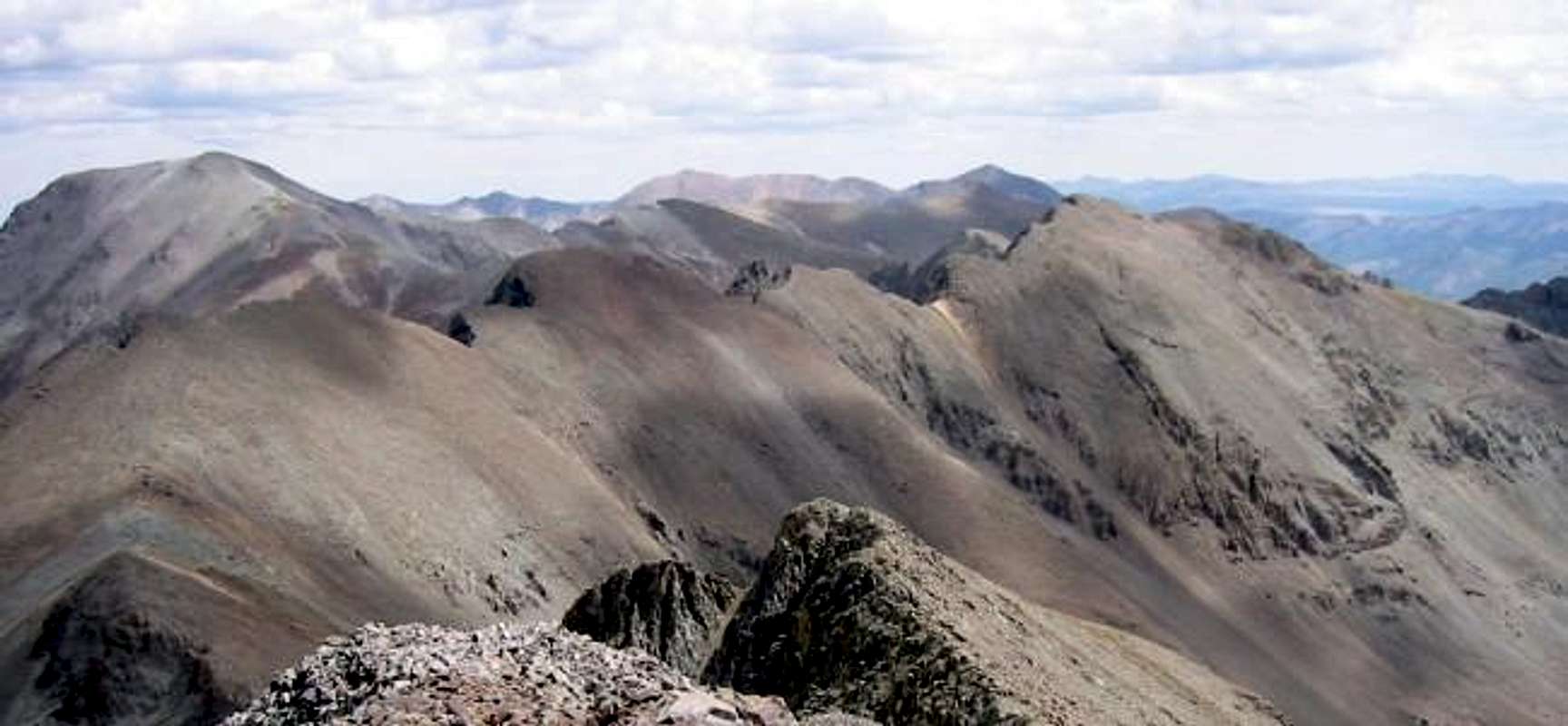
"American Peak" from Jones Mountain before three Fourteeners: Handies Peak, Redcloud Peak, and Sunshine Peak.
 American Peak is the 102nd highest summit in Colorado. It is an archetypal San Juan summit in the Lake City region. The USGS accepted the nomenclature of American Peak as this summits name on July 16, 2005, making it one of the most recently designated "official" summit in the state. It exemplifies the charms that only the San Juan offer. Taking its moniker from nearby American Basin, American Peak anchors the north end of the Jones Mountain Group. It lies in close proximity to both Jones Mountain (0.8 miles distant) and Niagara Peak (1.4 miles distant); and combines well with these mountians. "American Peak's" most famous nieghbor is Handies Peak (1 mile to the north). The remarkable view from Handies Peak's summit indulges in the beauty of American Peak's riven north face across lush American Basin.
American Peak is a ridgelike mountain composed of loose volcanics and cut with north facing couliors. The 13,806 foot summit is the highest point along this east to west ridge line. It offers both sanguine snow couliors and some sedate ridge routes. The easiest route up is the West Ridge but as the author has ascended the South Ridge that will be described as well. The complete traverse of American Peak's summit ridge offers a unique perspective on American Basin. Looking down on the sparkling bluish-green waters of Sloan Lake is a memorable experience. Since the author has only partaken of the ridge routes the couliors are currently undescribed.
American Peak's geology is typical for the Lake City Caldera. Loose volcanic rocks create some magnificently rotten cliffs as well as providing for fertile soils on the expanses of alpine tundra beneath the summits. The region around Lake City consists of some 13 erodded, interlocking, volcanic calderas that serve as silent reminders of the fiery violence that shaped this section of Colorado some 22 million years ago. The summits in the area often mark the rims of these long collapsed magmatic wells. A testament of the instability of the rock in the area is the nearby Slumgullion Landslide, one of the most extensive examples of mass wasting in the nation. 700 years ago a huge escarpment, undermined by gravity and groundwater, slid down the north facing slopes above the Lake Fork of the Gunnison to damn the river and create Lake San Cristobal.
The approach described for American Peak is from upper Snare Gulch. This is a beautiful basin that offers wonderful camping and hiking. In the summer it is reputed to be carpeted with wildflowers. Snare Gulch is cradled by the Jones Group and the summits around Half Peak, so a stay here offers quite a range of mountains to climb. Additional approaches are possible via Burns Gulch or American Basin.
 |  |  |  |  |
Getting There
To get to Snare Gulch one must first get to charming Lake City. From downtown Lake City proceed south 2.2 miles to the Lake San Cristobal Road. Turn right here (southwest) and follow the road around Lake San Cristobals west side. Continue on till the junction with the Sherman and Cinamon Pass Roads (14.3 miles from downtown Lake City). Turn left onto Sherman Road and follow it through the Sherman townsite, past the Cataract Gulch Trailhead to where the road may become too rough for your vehicle. If you have a fourwheel drive you can continue on this road; henceforth refered to as the Snare Gulch Road. A good parking area exists at the Cuba Gulch Trailhead 3.4 miles further. It is possible to follow the road further into lower and then upper Snare Gulch. The headwall that seperates these basins is climbed by the Snare Stairs, a series of 13 switchbacks. It is possible to drive all the way up into Upper Snare Gulch. This greatly shortens the climbs and should only be attempted by those with suitable vehicles. If you do attempt this drive STAY ON THE ROAD. It is Illegal to go offroading in this section of National Forest
 |  |  |  |  |
"American Peak's" Couliors
This section is to describe the snow climbs on American Peak's north facing couliors. Although the author has not been on any of these routes to date I shall add information as soon as it is available. Curently I am using Information from Gerry and Jennifer Roach's excellent guidebook "Colorado's Thirteeners: 13,800 to 13,999 Feet". The names given are taken from this guide. The couliors are (from west to east):
Traitor Coulior: Steep Snow
Independence Coulior: Moderate Snow
Patriot Coulior: Moderate Snow
Victory Coulior: Moderate Snow
 |  |
When to Climb
The San Juans get monumental snowfalls durring the winter. That limits the climbing season from June through November. Although Avalanche safe routes may exist on American Peak approaching the mountain would require expert Avalanche avoidance. The steep sided drainege of Snare Creek would surely be a dangerous death trap with a heavy blanket of snow.
The snow couliors obviously require snow to make a decent climb. I believe they are in condition from may into june. Here again I stress I have not personaly climbed any of American Peak's snow couliors. Too early in the season and they could be avalanche prone... Too late in the season you will learn why the San Juans are infamous for loose rock.
Red Tape
No permits required. American Peak is outside the nearby Uncompaghre Wilderness but does not lack for wild attributes. Please treat this area with respect as it safeguards beauty in abundance. Perhaps one day our legislators will give this area the protection it deserves.
Maps
"American Peak" lies within the Gunnison National Forest. It is covered by the Trails Illustrated Map 141. Routes are also depicted on the Topo! map below.
 |
Camping
Excellent Camping is available in both the lower and upper reaches of Snare Gulch. As Snare Gulch is accessed by a four wheeldrive road car camping is an option. Upper Snare Gulch is seperated from lower Snare Gulch by the Snare Stairs. This rough set of 13 switchbacks is better hiked but can be driven by a determined four wheeler. Upper Snare Gulch offers opportunities of camping next to one of the many lakes that grace this basin.
Many established campgrounds are also in the area (especialy around Lake San Cristobal). Here is a link to information about campgrounds administered by the state, some of which charge fees: Colorado Campgrounds
 |
Weather Forecast

JonBradford - Jun 14, 2005 7:36 pm - Hasn't voted
Untitled CommentThank you for the spelling correction. I am at time horrible at spelling and it was just recently that I figured out how to spell check text before submitting it to SP. I'll try and correct all the "couliors" that may be on the American Peak page. If you do any of these couloirs this summer please submit photos or info. I'll see to it that it gets prominently displayed.
Cheers.
Jon
JonBradford - Nov 26, 2005 9:56 am - Hasn't voted
Untitled CommentThank you Tim for keeping me posted. I'll add this information to the page.
Jon
virginiapine - Jun 14, 2005 12:59 pm - Hasn't voted
Untitled CommentEnglish-speakers call them gullies. Since the word in the French climbing lexicon is being used here, may as well spell it correctly - couloir (pronounced 'cool-wahr').
Cheers and I hope to enjoy these routes soon.
JonBradford - Jun 14, 2005 7:36 pm - Hasn't voted
Untitled CommentThank you for the spelling correction. I am at time horrible at spelling and it was just recently that I figured out how to spell check text before submitting it to SP. I'll try and correct all the "couliors" that may be on the American Peak page. If you do any of these couloirs this summer please submit photos or info. I'll see to it that it gets prominently displayed.
Cheers.
Jon
TimFlannery - Nov 22, 2005 5:24 pm - Hasn't voted
Untitled CommentAs per my proposal to the GNIS, the USGS officially accepted the naming of American Peak as of 7/16/2005.
JonBradford - Nov 26, 2005 9:56 am - Hasn't voted
Untitled CommentThank you Tim for keeping me posted. I'll add this information to the page.
Jon
jrf - Jul 21, 2009 11:21 pm - Hasn't voted
Road ConditionsAt least at this time the road into upper Snare Gulch is closed at Cuba Gulch 4wd parking. There are a ton of large trees down across the road past this point as well as a marked closure. Unsure how long it has been like this but it didn't appear to be all recent from last winter.