

|
|
Mountain/Rock |
|---|---|
|
|
39.64280°N / 105.8208°W |
|
|
14267 ft / 4349 m |
|
|
Overview
Along with its nearby neighbor Grays Peak, Torreys Peak holds the distinction of being the only 14,000-foot peak on the Continental Divide. Highly visible from Interstate 70, Torreys is a memorable symbol of the ruggedness of Colorado's Rocky Mountains for millions of passing climbers and non-climbers alike. Although Mounts Evans and Bierstadt are closer 14ers to Denver as the crow flies, the close proximity of Torreys and Grays to the interstate and a well-trodden path to their summits ensures plenty of climbing activity around the year. While the crowds might create a fun, sociable environment for gregarious hikers, the parking lot fills up rapidly on summer weekends, and it often is standing room-only on the summits of both peaks.
Torreys is a large, complicated mountain with a variety of routes for climbers of many skill levels and interests. The standard route, a walk-up from Stevens Gulch, follows the Grays Peak trail to the Grays/Torreys saddle (13,700 feet), and then ascends Torreys's south slope. Excellent hiking routes also exist from Loveland Pass to the northwest and Chihuahua Gulch to the southwest. While there are no recognized technical routes on Torreys, this peak is home to several classic scrambles, snow climbs, and ski descents. The class 3/4 Kelso Ridge route ascends Torreys's northeast ridge in style, with sustained scrambling on clean rock, and an unforgettable knife-edge. The most popular snow climb (and expert ski descent!) is Dead Dog Couloir, with 50° slopes and a convenient finish near the summit.
Many other interesting climbs exist on Torreys's steep and broken north face, the easiest being the class 2 Northwest Slopes. Emperor, described by Gerry Roach as "one of Colorado's longest snow climbs", is the mountaineer's highlight. These climbs and others start from Grizzly Gulch.
 |
 |
 |
 |
 |
Getting There
| Routes from the Northeast | 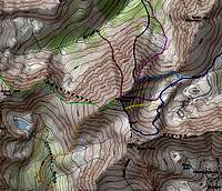 Click on map for area overview Dark Blue - Grays Peak Trail Yellow - South Paw Couloir Purple - Dead Dog Couloir Light Blue - Kelso Ridge Pink - Eroica Black - North Ridge Red - Emperor Green - West Ridge Orange - Chihuahua Gulch |
|
| Stevens Gulch Trailhead |
From Denver take I-70 West to the Bakerville exit #221 and proceed south on forest service road 189. Look for the brown forest service sign pointing the way to Grays Peak. Depending on road conditions, the clearance of your vehicle, and the number of cars in the Stevens Gulch trailhead parking lot, drive ~2 miles to the trailhead (elevation 11,150 feet). Routes: Standard route (Grays Peak trail), Kelso Ridge, Dead Dog Couloir. | |
| Routes from the Northwest | ||
| Loveland Pass Trailhead |
From Denver take I-70 West. Near the Loveland Ski Area, exit US Highway 6 west. At the top of Loveland Pass (12,000 feet) on the left is a parking area. Routes: Loveland Pass | |
| Routes from the Southwest | ||
| Chihuahua Gulch Trailhead |
From Denver take I-70 West. Near the Loveland Ski Area, exit US Highway 6 west. Proceed over Loveland Pass. At the east end of town, take Ski Valley Road south, which almost immediately becomes CR 6, which turns into CR 5. After 4 miles, turn left onto CR 260 BEFORE you hit the tiny town of Montezuma. Continue for 2 miles; a parking area is on the left with a fenced/bermed gate (elevation 10,500 feet). Routes: Chihuahua Gulch. | |
| Routes from the North | ||
| Grizzly Gulch Trailhead |
From Denver take I-70 West to the Bakerville exit #221 and proceed south on forest service road 189. Look for the brown forest service sign pointing the way to Grays Peak. Continue for 1 mile, turn right onto FS road 189.1C for 0.3 miles and park. Four-wheel drive vehicles may continue about 2 miles up Grizzly Gulch. Elevation 10,320 feet. | |
 |
 |
 |
 |
 |
Camping/Red Tape
US Forest Service, Clear Creek Ranger District
101 Chicago Creek Road
Post Office Box 3307
Idaho Springs, CO 80452
Phone (303) 567-3000
TTY: (303) 567-3009
Fax: (303) 498-3021
When To Climb
When to climb? Year-around! Most hiking routes are accessible for casual use from June to October, depending on snow conditions. Road closures add two miles and considerable elevation gain to a Stevens Gulch winter approach. The easiest winter approach is via Loveland Pass, which is snowplowed to nearly 12,000 feet. Check the Colorado Avalanche Information Center for updated avalanche information.
 |
 |
 |
 |
 |
Mountain Conditions
- 24-hour weather data at Loveland Pass, elevation 12,000 feet.
- Colorado Dept. of Transportation's I-70 report, including Loveland Pass. This site also has webcams placed strategically along I-70.
- Loveland Ski Area's Snow Report, including Loveland Basin webcam
- Weather Underground forecast for Dillon, CO
- Weather Underground forecast for Georgetown, CO
 |
 |
Acknowledgements
mwalker2 supplies an excellent summary of approach info to Chihuahua Gulch, both written and in maps. marcminish has great information on the Loveland Pass route page. odysseus's maps are very helpful. Also thanks to mpbro who maintained the page before I got it and put the vast majority of work into it.
External Links
- Johnathan Regele - Emperor snow climb
- Kelso Ridge - October 15, 2000
- Torreys and Grays by standard route
- Torreys peak, a summit like it should be
- A trip report and pictures of Torreys Peak and the Dead Dog Couloir route
- Dead Dog Couloir Trip report
- Torreys Peak Sunrise
- Kelso Squared -- Kelso Ridge & Kelso Mountain
- Torreys via Kelso Ridge
- Via Loveland Pass (04/04/2004)
- Torreys Peak (06/05/2004)
- Dead Dog Couloir (05/28/2005)
- 14ers.com - The Home of Colorado's Highest Peaks
Fourteener Photos, Route Descriptions, Forum, and more...
jhughes - Aug 17, 2014 11:19 pm - Hasn't voted
lost dog -JacksonMy boyfriend and I lost our dog Jackson at the grays and Torrey's trailhead. He is a black lab pointer mix with a little white around his nose and chest. He is one year old. He has a microchip and has registered as missing. Any updates or info on sightings would be greatly appreciated. Thanks Jessica
Mcknight30 - Oct 22, 2014 5:22 pm - Hasn't voted
Kelso's on 10/25/14I'm looking to climb Torrey's via Kelso's ridge this Saturday and i had a couple of questions regarding conditions and possible camping(more like sleeping in the car or a quick tent) I spoke with the sheriffs office and thwy said the road leading to the TH for Steven's Gulch was pretty messy right now but i hopeing after a few days it will clear up. Worse case i guess i'll have to park off of I-70. My question is, 1.) Will this most likely be a snowshoe approach to the saddle? And 2.) is there any possibility of me either setting up my tent or sleeping in my car the night before anywhere near the TH or trail.