
-
 46080 Hits
-
 92.85% Score
-
 40 Votes
|
|
Mountain/Rock |
|---|---|
|
|
46.26632°N / 13.65862°E |
|
|
Hiking, Mountaineering, Trad Climbing, Scrambling, Via Ferrata, Skiing |
|
|
Spring, Summer, Fall, Winter |
|
|
7362 ft / 2244 m |
|
|
Overview
Name Games
Krn has an interesting flip-flop history, related to his name. In Slovenian language krn means that what remains when the rest is cut off. Stump would be a close-by translation, even if not the completely exact one. In the sad history of the western part of Slovenian national territory it happened that Italians occupied the country. They heard people naming their mountain "Krn" and confused that word with "črn", which means "black". As they had to italianize everything, they translated mountain name into "Monte Nero". And that name, completely irrelevant, is persisting still today.
General remark: (When reading Slovenian words on maps or in books, you will find special characters for ch, sh, and zh. They are written with c, s and z with a caron - little v above them.).
Krn Gets Presented
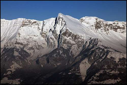
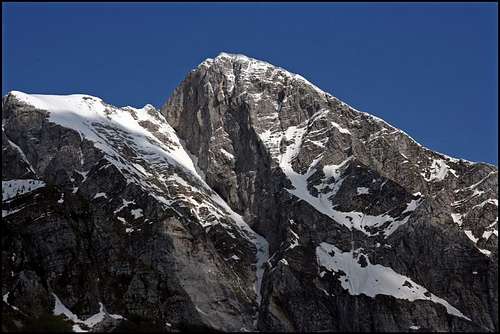
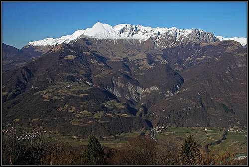
Although not so high, Krn is one of the most important mountains in Julian Alps. Wherever in Slovenia you stand a little higher, you will see it's characteristic nose. It is high enough to be prominent in its own mountain group and it is remote enough from the rest of high Julian summits.
Books are written about Krn, it came into history, it is a symbol and the beloved mountain of western regions of Slovenia.
The summit is easily ascended, but offers also various challenges in all seasons. Mountaineering, climbing, mountain biking, parachuting, tour skiing and more.
Geological Outline
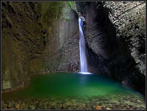
In order not to go too much into details, let's focus here only on the summit area of Krn mountain. This one is geologically quite simple - it is built of dachstein limestone from the upper triassic era, the rock, which is forming many summits in the Eastern Julian Alps. Towards the south and west below these limestone slopes unconsolidated morraines and rubbles are covering the slopes. But further down the slopes the picture gets much more diverse. Different rocks from the cretacious period are forming more or less thick layers, so no wonder why the look of Krn's 2000 meters high southern slope is so diverse. Steep ravines, ridges, many waterfalls, falling even 100 meters, etc. Will try to describe more, if this page evolves further...
 |
 |
 |
 |
 |
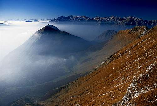
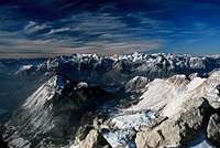
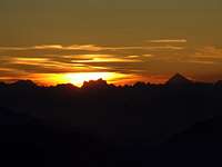
Summit Views
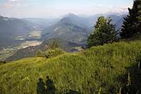
No need to say that from the summit of Krn panorama is immense - you can see its eastern part on the picture to the left. From Krn you see well the Adriatic coast, the rest of hilly Slovenia, all high peaks of Julian Alps and a picturesque neighbourhood with fresh green valleys and turquoise Soča river.
Towards the north your attention will first go to Krn lake, lying deep down in the valley, surrounded by the last trees and greenery. Behind the lake, towards the NE higher mountains of Bohinj group already begin and above all of them the high throne of Triglav is reigning. Left of Triglav all the highest summits of Julian Alps are visible.
Towards the west Viš and Montaž group, Kanin group and Julian Prealps will catch your eye. Behind them are the more distant peaks of Carnic Alps and Dolomites.
Towards the east you see first the neighbouring summits of Krn group and behind them the long South Bohinj Range.


General Orientation
 |
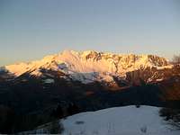
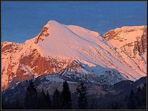
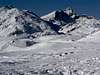
 tynishaphotography - Winter Krn tynishaphotography - Winter KrnKrn group lies on the very south edge of Julian Alps (East, Slovenian part). On north, west and south the border is Soča river and its tributaries, on east the group connects to South Bohinj Range. |

The Southern Slopes of Krn
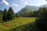
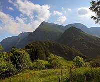
They are very high - more than 2000 meters above the beautiful Soča river. If you are looking on Krn from the opposite side of the valley (Kolovrat hill) the scenery is great: Deep below the turquoise river, surrounded by green meadows, above it steep, wild slopes where you can distinguish a few waterfalls falling through the woods, between wild rocks several plateaus with small villages, the last one (also named Krn, 960 m) being already at the bottom of a big amphiteater. Above 1000 meters the slopes are grassy, very broad, intermitted with rocks.
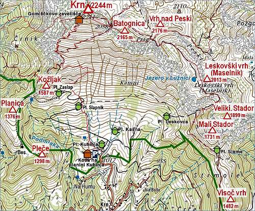
The neighbouring, lower mountains at the east are more rocky, some of them falling also towards the south with steep walls. These are: Batognica, Vrh nad Peski, Maselnik, Veliki Stador, Mali Stador, Visoč vrh and further towards the south smaller summits like Mrzli vrh.
The shorter SW ridge rises once again to the grassy summit of Kožljak, 1602 m, then lowers much to the beautiful, grassy Planica, thene to Pleče, after which it lowers down towards Soča.
Towards the north
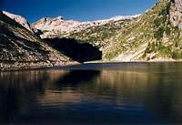
the slopes are more steep and rocky, but the mountain also offers no big opportunity for climbing here. After 200 meters or some more a high carst plateau begins and rocky terrain is falling down into a beautiful valley where the Krn lake lies (1390 m).
Towards the NW Krn sends a strong, many kilometers long ridge, named Krnčica. It has several peaks, the last of them is the shoulder of Kal, 1700 m, from which the ridge sinks down into the woods above the valley of Soča river.
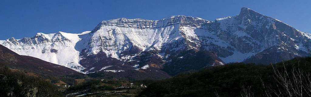
West face
is perhaps the most interesting side of Krn. It is 900 meters high, rocky, steep, giving a chance only to one ferratta and few climbing routes. Below the west face on a beautiful terrace a very picturesque Drežnica village lies.
|
|
Frontline in World War I
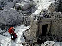
WW1 barracks
Memories on WW1
In the World War I over the main ridge of Krn group the frontline went. On Kal (the last shoulder of the long NW ridge) Italian and Austro-Hungarian positions were only few meters apart. The NW ridge was Italian, after the famous surprise attack also the summit of Krn was taken. The neighbouring summit of Batognica (2164 m) was no-one's land. It is plateau-like and just across it the frontline didn't move for years. Soldiers were in trenches only 15 meters apart, freezing, starving, dying, and of course being again and again replaced by freshmen. Both sides tried to dig tunnels below the very summit to reach below the opposite side and blow them up with dynamite. Stil today a crater of one such attempt can be seen on the summit plateau. And so on towards east. The frontline didn't move till 1917 when the great combined attack of Germans and Austro-Hungarians started, moving the frontline in a few weeks far westwards to the river Piave.
If you are hiking today along the frontline, you will find many still well preserved remnants of this war. Individuals and organized groups are collecting them, much material is already in museums, much more still between rocks.
A nice goal of a short one hour hike can be also the Italian chapel, named Bes. It stands close to the saddle between Planica and Pleče.
There are many internet pages on these events, unfortunately not so many in English. The most beautiful page in Slovenian language is this, and from it here are many links to English pages. But they are not mountaineering oriented. Also, there is a good museum of the WW1 in Kobarid. If you are in the area, it's a must to visit it.
 |
 |
 |
Getting There
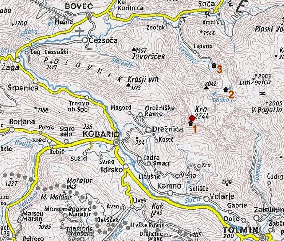
Soča valley can be reached from the south (from Italy over Gorizia, from Slovenia over Idrija or Ajdovščina) or north (over Vršič Pass from Sava valley or over Predel pass from Tarvisio). It's also possible to arrive there from the west, from Udine over the Učja/Uccea pass or from Udine to Cividale and then to Stupizza pass - so reaching Kobarid and then Drežnica or Krn village.
Krn itself is most comfortably approached from the south. Through the Soča valley the regular bus line is operating. By car you can drive from the south up to the Krn village (960 m) and Kuhinja meadow, 1000 m, or from the western side to Drežnica village (540 m). Above Drežnica, the alpine meadows of Zaprikraj and Zapleč (1200 m) can be reached by car, but from them, you must take an ascent over the long NW ridge. Remember again - ascending the summit from the Soča valley is a 2000 meters of altitude endeavour. From the north you can drive by car into Lepena valley (700 m) where the trailhead starts, bringing you to the Krn lake. Many tourists also ascend Krn from Bohinj valley - far on the east - especially in times of tour skiing or long range hiking.
 |
 |
 |
Routes list
Only three most obvious routes are named and shortly described here.
1. From the south.
From Krn village (960 m) you continue by a narrow road to the alpine meadow Planina Kuhinja (1000 m) from where you continue by a marked path towards the north. All the slope is clearly ahead of you, in 3 hours you will reach the top. This slope is also perfect for skiing in winter and early spring.
2. From Krnsko jezero
First you must reach Krnsko jezero (lake) on the northern side (to the hut there you will need 2 hours from the Lepena valley). The marked path further goes by the lake, reaches the alpine meadow Planina Na Polju (1520 m, water) and continues by a shallow valley towards the south. In two hours you will reach Krnska škrbina (notch, 2058 m) where you turn right (westwards) and reach the summit in next 20 minutes. All the time easy, marked hike, in winter also a fine ski tour.
3. From Drežnica village.
From the village inn the marked path goes toward the east, after crossing meadows it soon becomes more steep and over the slopes of Krn's south neighbour Kožljak it ascends to the southern shoulder. From there as in No. 1 to the top. If you like climbing by ferrattas you can choose a variant. 45 minutes from the village the marked route deters left towards the steep western face. First it climbs by its left side, just below the hardest summit rocks the route crosses the slope towards the exit south of the summit. Very attractive, but steep and exposed. In the last earthquake this route was damaged, but now it's repaired again. Pegs and ropes are occasionally damaged also by falling rocks and avalanches.
Krn from below Planica ridge
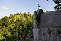
Bes chapel from the WWI
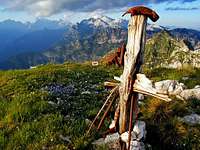
4. Planica from Kuhinja meadow.
This is a nice, easy (T2) and short hike (3 hours), which can be prolongated as you wish. Its primary objective is the Bes chapel and the wonderful, grassy ridge of Planica. June is perhaps the most beautiful time, but a clear autumn day can rival it. On the map above the path is drawn as not marked, but in fact it bears the marks of Alpe-Atria trail.
From the mountain hut on Kuhinja meadow we go always by the road towards Krn. On the big right turn before Slapnik meadow, we leave the road and continue westwards. The path soon descends some 30 m, but then continues crossing the slopes around a broad, forrested ravine. On the other side we are soon on the grassy saddle south of Planica. To the chapel there's only a few more minutes.
From the saddle it is nice to continue northwards, on Planica. The non-marked shepherds path crosses the eastern slopes, but it is far more beautiful to go by the panoramic ridge. After crossing, we reach the saddle Na opekah, SW of Kožljak. From there we continue by the mountain road right on Zaslap alpine pasture and then return down. The alternative is to proceed from Na opekah saddle steeply up on Kožljak (I don't know how difficult that path is) and further even on top of Krn.
 Shepherds path Shepherds path |
 The view from Planica The view from Planica |
 Krn from Planica Krn from Planica |
Maps:
- Krn. Planinska zveza Slovenije, 1:50000 (classical map)
- My online map-guidebook.
 |
 |
 |
 |
 |
Red Tape
The whole area is part of Triglav national park. Which means nothing for you. You should anyway preserve nature and leave it as it was.
Except the main routes, these mountains can be quite lonesome. If you arrive with a tent and make it through the night, possibly no one will bother you.
If you will hike or climb over the remote parts of the massif, you might be lucky and find relics from the World War I. Please leave them there. No need to say that they might be dangerous too. Every year many unexploded items are still found. On the other hand don't worry, hiking everywhere is safe - here are no mine fields.
When To Climb
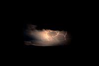
Storm
Krn can be ascended almost any time of the season.
In winter and spring west face is of course an extreme alpine endeavour. Also other approaches can be in hard winter (when slopes are icy or there is a danger of avalanches) very dangerous. A few years ago a group of Italian mountaineers, well equipped for a winter climb, slided down the slope together with a big plate of snow and many of them died. Otherwise the best months are April and May for tour skiing, June and July for flora admiring, August to October for enjoying panorama.
Weather: see the official page for Slovenia here.
Even better site is wunderground - here's the direct link to Kredarica station, 2515 m (below Triglav summit).
 |
 |
 |
 |
 |
Camping
In the valley of Soča you will find everything a tourist could wish. Accomodation of course too, either in camps in hotels or in private rooms.
After you turn the speakers off you will may be find some valuable information here.
On the mountain there are the following huts:
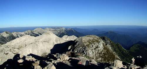
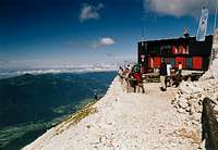
1. Gomiščkovo zavetišče (hard to pronounce, a?) just on the summit of Krn. Opened in summer.
2. Planinski dom pri Krnskih jezerih (The hut by Krn Lakes), 1385 m. Opened in summer.
3. Koča na planini Kuhinja, 1002 m. On the S slopes of Krn, 10 minutes from the parking place.