
-
 19109 Hits
-
 85.36% Score
-
 20 Votes
|
|
Area/Range |
|---|---|
|
|
46.26110°N / 13.76180°E |
|
|
Hiking, Mountaineering, Scrambling, Skiing |
|
|
Spring, Summer, Fall, Winter |
|
|
6840 ft / 2085 m |
|
|
Overview
What's New On This Page?
> March 18th, 2020: A complete page renewal.
The Character
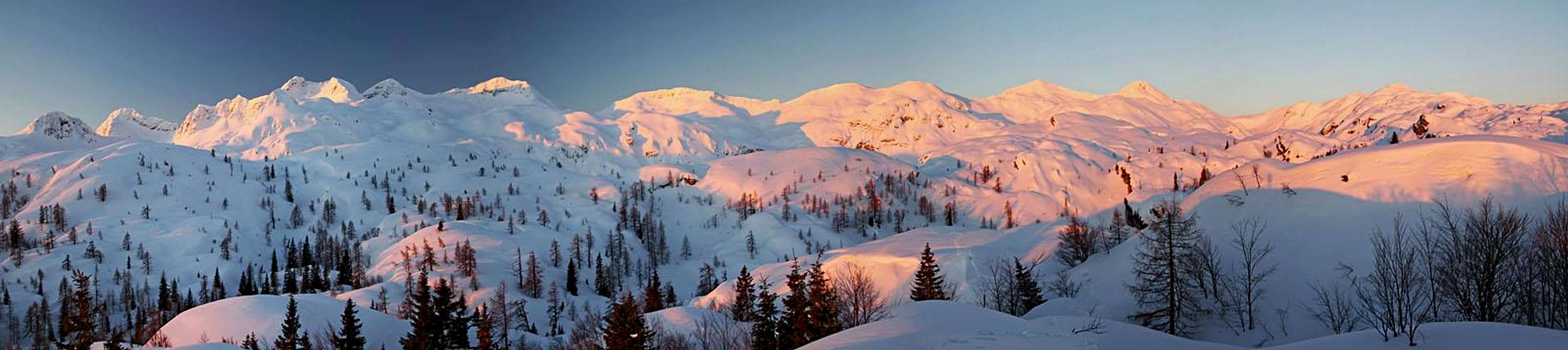
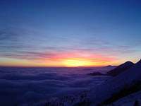
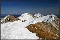
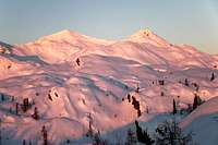
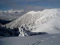
Dawn on the Komna plateau - the western part of South Bohinj Range
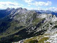
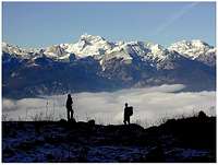
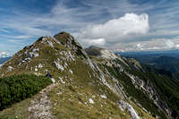
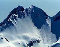
The main ridge
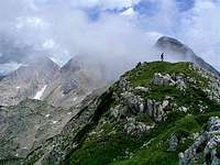
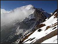
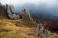
On the ridge
The South Bohinj Ridge (or the Lower Bohinj Ridge) is one of the longest compact ridges of Julian Alps. Considering only the Slovenian part of Julian Alps, this is the first chain of high mountains from the south. Like a giant arc it encircles the primeval Bohinj valley, causing that this beautiful part of the World, being on the north surrounded by the even higher Triglav group, stayed for centuries withdrawn from the rest of the country. More about Bohinj, see on the page of Bohinj group.
The ridge stretches around 30 km in the east-west direction and is from 7 to 15 km wide. On the north its border is the Bohinj valley (the valley of Sava Bohinjka river). From the south, these mountains are bounded by the rivers Bača, Tolminka (both tributaries of Soča) and Soča itself. On the west, the Lepoče valley separates the South Bohinj Ridge from the Krn group and while the ridge gradually turns northwards it is considered that it geographically ends with the Vratca Pass (also: Bohinjska Vratca, 1803 m). On the east, the Bohinj Pass separates the group from lower foothills stretching further towards the east. So, by most geographers the South Bohinj Range ends on the Bohinjsko sedlo (Bohinj Pass), but we shall consider as part of it also the massif of Ratitovec, stretching east of Bohinjsko sedlo.
If you expect that Julian Alps consist only of high, vertical walls and wild ridges you might be dissapointed with the South Bohinj Ridge. These mountains are steep, but because of their relatively low altitude they are more grassy and thus offering hiking and tour skiing possibilities. The highest peak of the group is Tolminski Kuk, 2085 m. Although these mountains are not very high, because of deep valleys the altitude differences are very considerable. Tolmin, one of the points of departure on the south, lies only 200 m above the sea level and Bohinj lake on the other side lies 525 m above the sea level.
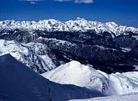
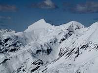
The view on the whole crest from the NW, across the Komna plateau
Cultural Aspect
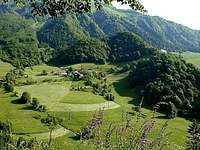
In the valleys north and south of the ridge Slovenian people live. It is interesting that in the 13th century, when these areas were still unpopulated, the bishophs of the German Freising gave much of that land to their farmers from Tirol (from around Innichen). Immigrants had some benefits and in a century they populated the slopes above Baška grapa and the sunny terrace below the Ratitovec. For centuries they kept contacts with Tirol, but in the last 150 years they melted almost completely with Slovenians.
Summits: red = summits with SP page, orange = other important summits, yellow = less important summits.
Huts (brown), landmarks (light blue), trailheads/parking places (dark blue)
Highlights of the Group
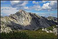
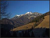
Triglav from below Črna prst
The character of the South Bohinj Ridge is alpine. Although its peaks hardly reach the 2000 m limit the whole group from the peak of Črna prst towards the west nowhere lowers below the 1700 m limit. So you can imagine why the most recommendable hiking is crossing the whole ridge. The tour can be done in two days. Hiking by the top of the ridge is rewarded by an amazing panorama: towards the south and east, the rest of hilly Slovenia, ending with the Adriatic coast, towards the north and west, the highest Julian Alps peaks with his Majesty Triglav in the centre.
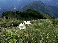
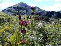
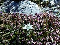
In early summer the South Bohinj Ridge is known by it's abundance of flora. Due to special geological conditions, especially Črna prst is famous by its flora. Mountain spring (May till early July) is besides late autumn the most beutiful season for hiking.
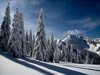
A special natural phenomenon is also the high karst plateau of Komna. Shattered limestone rocks are covered with dwarf pines, so outside paths the terrain is extremely hardly passable. But in winter this plateau changes into a white sea of soft hills, ideal for tour skiing.
Last but not least, we must mention the tranquil Bohinj lake, more than 4 km long and almost 1 km wide mountain pearl and Savica river, its tributary, best known by it's beautiful, more than 50 m high source waterfall.
 On Črna prst |
 Below Vogel |
 On Zeleni vrh |
Getting There
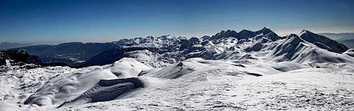
The southern terraces
The South Bohinj Ridge mountains can be reached from the south and from the north. Some important trailheads and parking possibilities can be seen on the map above. From the south, you follow the dreamy beautiful valley of Soča river. You will nowhere in Europe find a river of a such light blue colour. If in a small town Most na Soči (The Bridge on Soča) you turn right (eastwards), entering the Bača valley. Most of the trailheads are above it, but the easternmost are lying beyond the Petrovo sedlo (road pass) and can be reached also from the other side. That's the direction from Škofja Loka, from where you drive up the Selška Sora valley.
Through the valley of Bača also the railroad goes (and through a tunnel further on into Bohinj valley).
Driving north from Most na Soči, you will soon reach the Tolmin town. From there a narrow mountain valley goes further north, reaching the base of the western part of our group.
From the south a few mountain roads climb up to remote villages and hamlets, which can be used as departure points of mountain tours. But they all lie quite low, up to 800 m of altitude.
North of our mountain range the Bohinj valley can be reached by a good road from the well known tourist resort of Bled. But again, the road goes only by the south bank of the Bohinj lake and the mountaineer must climb the whole height difference to mountain peaks. If you have a good map, perhaps you will find a forrest road, starting in Bohinjska Bistrica and climbing up to the altitude of 1000 meters.
From the west bank of Bohinj lake a cable car can take you to the altitude of 1540 m (Rjava skala). This is one of the most renowned panoramic points in Slovenian Julian Alps, opened to the mass tourism. In winter there is also a good ski resort.
Important Peaks
Starting from the east some most important peaks of the group are:
| Broad, easternmost plateau-like massif north of the Selška dolina (valley). Summits: Kosmati vrh, 1643 m, Gladki vrh, 1667 m, Altemaver, 1778 m, Kremant, 1658 m. Nice for hiking and ski touring. On the south, precipitous rocks are falling down on a terrace with nice, remote villages. | A handful of rounded, panoramic summits around the Soriška planina (pasture). Summits: Dravh, 1548 m, Lajnar, 1549 m, Slatnik, 1600 m, Možic, 1602 m, Šavnik, 1576 m. In summer some easy, (round) hiking tours, in winter short ski tours, supported by the chair-lift of Soriška planina. | |||
 Kobla, 1498 m |
A ridge mountain with gentle northern slopes and much steeper southern face. East of the summit is the ancient pass of Vrh Bače, for centuries used for trading. From Bohinjska Bistrica ski terrains and a chair lift are reaching almost to the summit. | First higher summit from the east. In the main ridge east of the highest point there's the unimportant Šoštar, 1646, on the west there are Četrt, 1831 m, Konjski vrh, 1877 m and Poljanski vrh 1896 m. The two northern side ridges are hosting Črna gora, 1605 m, and Lisec, 1653 m. Just below the summit of Črna prst there is the hut, called Dom Zorka Jelinčiča, 1835 m. Črna prst is famous by its rich, partly endemic flora. On the southern terrace there's the nice village of Stržišče, in the valley below it, the Driselpoh creek formy a few cute waterfalls. | ||
 Raskovec, 1967 m |
Nice, 2-headed mountain in the central part of the ridge. The rounded Mali (=Small) Raskovec, 1945 m, rises NW of the higher brother, off the main crest. Veliki (=Big) Raskovec, 1956 m, is in the main ridge, the summit east of it is Matajurski vrh, 1936 m. The main marked path crosses just below the highest summit. | The very popular hiking and ski touring goal rises in the central part of the ridge. Good paths are reaching it from all sides. North of the highest summit is a high valley, more a plateau, surrounded with a handful of solitary, pathless summits, with altitudes between 1557 m and 1799 m. South of Rodica there are two nice, sunny villages: Rut and Grant. The first one was for centuries the centre of the German speaking community. | ||
|
Easily reachable ridge mountain, just south of the Vogel ski resort. From the upper chair-lift it's only some 30 min of ascent. |
|
One of the most important mountains in the range, equally easily reachable from the NE side (Vogel ski resort, cable-way) and SW side (Razor meadow, hut). | |
|
Quite a rocky, high mountain in the centre of the group. On the southern side characterised by a huge, steep slab of pure limestone. The summit is usually reached by a short ferrata. |
|
"Collapsed mountain", looking sharp and wild. No usual trail reaches the summit, no marked route either. But the climbing ascent is easy (UIAA I). | |
|
The highest summit in the range. It is surrounded by a couple of a bit lower peaks, especially interesting is due to its karst cave system Tolminski Migovec on the southern side. |
|
The two westernmost summits in the range. Mahavšček is sometimes (wrongly) also dubbed as Veliki Bogatin. Both are easily reached, but they are a bit remote. Both are also very nice ski touring goals. |
Routes
Routes in the South Bohinj Ridge mountains are mostly hiking routes. Only a few boulders in valleys and a few higher crags are appropriate for climbing. The majority of hiking routes is not difficult, but some of them require experience and some are also secured with pegs and steel ropes. Many routes are well marked (red circle with a white spot inside), but there are also many old shepards, hunters and forresters paths which can require good orientation skills.
Concerning mountain routes there can be many interesting combinations. They can be described on separate mountain pages or route pages. Here I will only outline the Grand crossing of the whole ridge:
1. Reach Črna prst (1844 m) - either from Bohinjska Bistica (3 h 30 min), from Podbrdo (3 h 30 min) or from Soriška planina (4 h - 5 h). In the last case you will really do the whole ridge.
2. Continue hiking over the main ridge to Vogel (1922 m). A well marked path goes mainly by the top of the ridge. After 4 hours you will be drunk of panoramic views!
3. Descend southwards to Koča na planini Razor (hut, 1315 m). There enjoy best-ever home made food and sleep over night.
4. Ascend Vrh nad Škrbino (2054 m) and continue by the top of the ridge westwards. Over Kuk the marked path goes all the way to Vratca (Pass, 1803 m). You will need almost 7 hours, and from there, you still need to descend. The best option is Bohinj (4 hours).
 |
 |
 |
 |
 |
Tour Skiing
There are several beautiful ski tours, here I will mention only a few:
1. Rodica (1966 m) is one of the classics here. The peak can be reached from the forrest road above Bohinj valley or from the ski resort Vogel. If you use ski lifts, they bring you to the altitude of about 1800 m, then you descend below the main ridge towards the east, climb the main ridge at Suha saddle (1773 m) and proceed to the top (3 h). The ski tour goes down through Suha valley and by forrest roads in Bohinj (1400 m of descent).
2. Vogel-Komna is a ski crossing, where you don't necessarilly reach any of the high peaks but is known by beautiful landscape. Ski resort Vogel (1800 m) - Planina Zadnji Vogel (1413 m) - Konjsko sedlo (1782 m) - under Podrta gora (cca 1800 m) - Planina Govnjač (1475 m) - Dom na Komni (1520 m) - Bohinj valley (Savica, 653 m).
3. Komna plateau offers you several ski tours with the altitude difference up to 500 meters. The best peaks are: Podrta gora (2061 m), Mahavšček (2008 m) and Bogatin (1977 m) and of course several more peaks towards the north, not belonging to the South Bohinj Ridge any more.
 |
 |
 |
 |
 |
Red Tape
No limitations. Keep nature as it is now. The whole range is part of the national park. If you are carying a tent you can sleep anywhere, but leave no trace behind. Have in mind that these mountains almost completely lack water.
 |
 |
 |
 |
 |
When To Climb
Early summer is best to admire flora. But in June days are rarely clear there. It is still best to choose a clear day with best visibility. These are most common in autumn. In winter many peaks can be reached by skis - offering some best possibilities for tour skiing. All the best ski descents go towards the north.
 |
 |
 |
 |
 |
Camping
From the east, the most useful mountain huts (koča = mountain hut) are:
Litostrojska kocha, 1306 m,
Dom Zorka Jelinčiča, 1835 m (on the peak of Črna Prst),
Ski hotel Vogel, 1540 m, Tel.: +386 4 572 13 01,
Koča na planini Razor, 1315 m, Tel.: +386 050 632 720,
Koča pri Savici, 653 m (in Bohinj valley), Tel.: +386 050 622 695,
Dom na Komni, 1520 m, Tel.: +386 4 572 14 75, +386 050 611 221,
Koča pod Bogatinom, 1513 m,
Dom pri Krnskih jezerih, 1385 m.
In Bohinj, by the lake there is a good camping place.
In Bohinj valley and around Tolmin you can find some hotels and private rooms.
 |
 |
Mountain Conditions
Weather: see the official page for Slovenia here.
Even better site is wunderground - here's the direct link to Kredarica station, 2515 m (below Triglav summit).
 |
 |
Older History of the Page
> January 1, 2005: Some links updated/inserted.
> May 30, 2003: Initial page set up.