
|
|
Mountain/Rock |
|---|---|
|
|
38.59800°N / 78.372°W |
|
|
Page |
|
|
4011 ft / 1223 m |
|
|
Overview
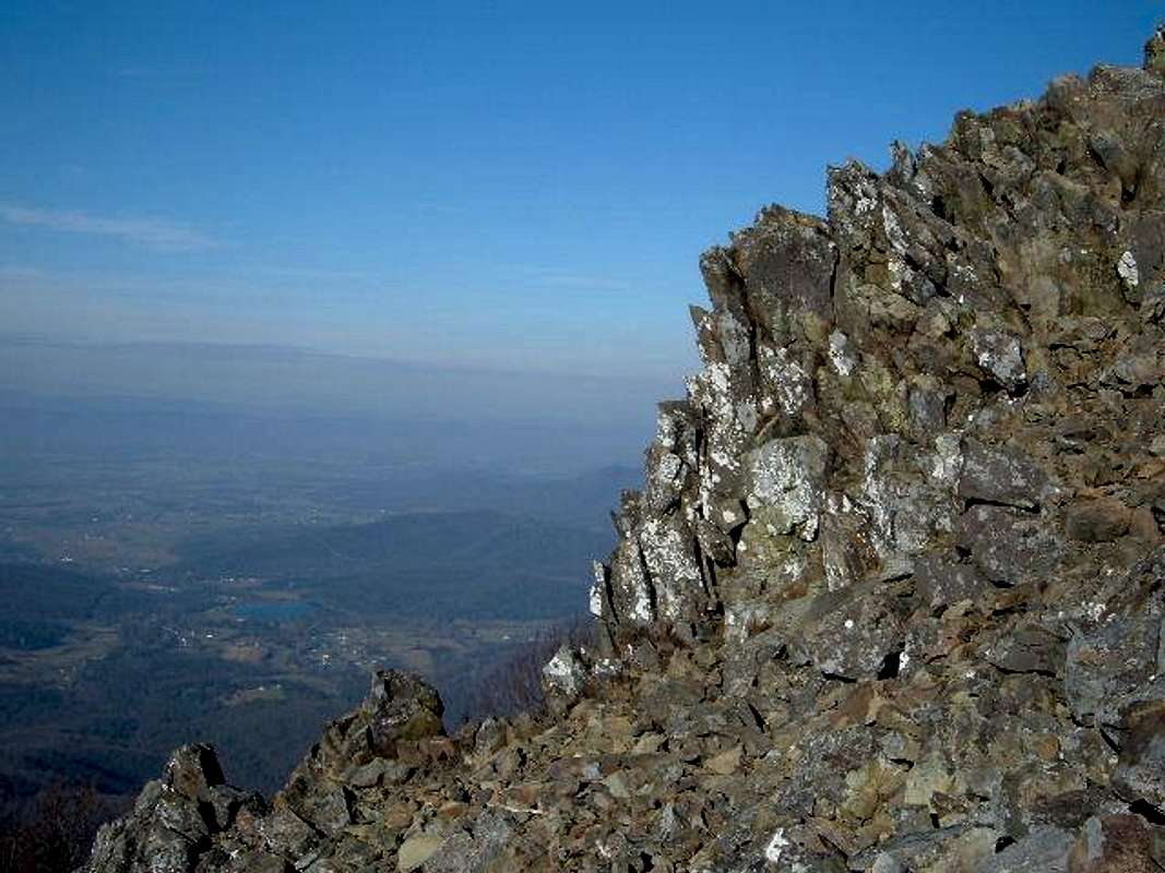
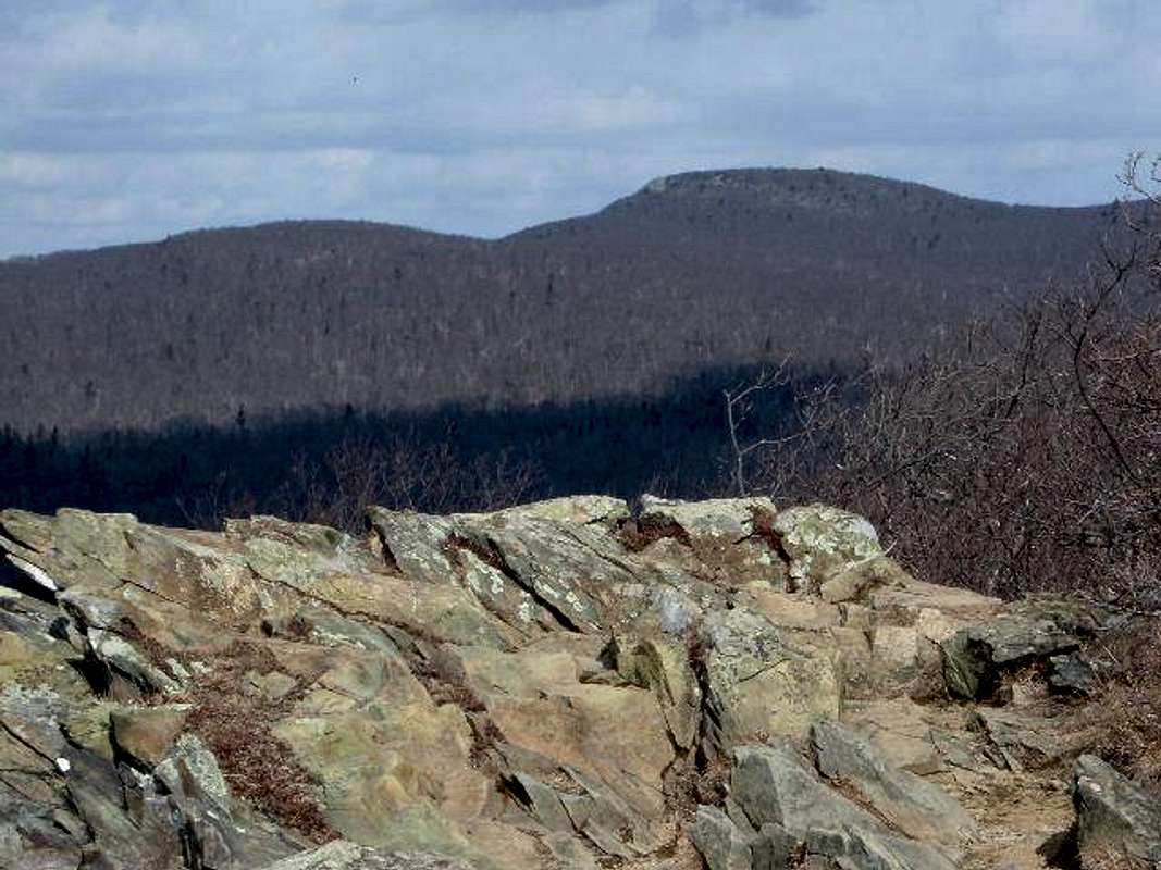 Stony Man is one of the prettiest mountains in the entire Shenandoah National Park. It is also the second highest mountain in the park, and the only other mountain that eclispes 4,000 feet. Once you reach the summit of Stony Man, you have great views to the west looking over the south fork of the Shenandoah River and beyond to the mountains in George Washington National Forest. The summit is free of trees and is pretty much a large rock outcropping with cliffs of 200' or more on the western ledge. This is a great spot for boulder hopping and offers plenty of interesting opportunities for your camera. The hiking options are relatively easy, as you can reach the summit in about 40 minutes from the Little Stony Man Route. The Appalachian Trail takes you to within a 1/3 mile of the summit and you use an access trail which leads directly to the top. If you want a really easy hike, you can get to the summit in less than a mile from Skyland. You can climb Hawksbill, the highest mountain in Shenandoah National Park, on the same day because the trailhead is only a few miles down the road.
 |  |  |  |  |
Getting There
From Washington, D.C. area, take Interstate 66 West to US Route 29 south. Follow Route 29 to Warrenton where you follow signs for route 211. Once you go through town, you take a right to stay on 211, which is 34 miles from Skyline Drive via the Thornton Gap Entrance. At this point, pay the fee and head south passing mile marker 39, and parking at milepost 39.1 at the small parking lot on the right which is named Little Stony Man Parking. Park here and follow the well-marked trail for about 1.5 miles to the summit (more information is described in the route section). There are several other trails. One is the short Passamaquoddy Route described in the route section. For a little longer hike, you can park at Hughes River Gap (milepost 38.8). Hughes Gap has a great, dead on, view of Stony Man. At the southern edge of the parking area, you can hike down a hill, passing some bathrooms. After you pass the bathrooms, you can hook onto the Appalachian Trail Southbound and hike about 2 miles to the summit. This trail joins the Little Stony Man route, since both use the Appalachian Trail. The round trip mileage on this hike is about 4 miles, with an elevation gain of just over 900 feet.
 |  |  |  |  |
Red Tape
Access to Skyline Drive cost $30 for an annual pass. If you do not live in the DC area, you can pay the $15 fee to enter Skyline Drive ($10 from December-February).
When To Hike/Climb
 Stony Man can be climbed year round. However, the park, or sections of the park, may be closed if road conditions are poor. Check with the park at 540-999-3500. Dial the number, press 4, and then 1 for the weather report and road closings.
 |  |  |
Camping
Backcountry camping is allowed throughout the park. A permit is required but there are no fees. The permit can be obtained thru mail or at entrance stations, visitor centers, or park headquarters. Campgrounds are located Mathews Arm (Mile Post 22.2), Big Meadows (Mile Post 57.5), and Loft Mountain (Mile Post 79.5). The Potomac Appalachian Trail Club has (6) cabins for hikers. They also publish maps. They can be reached at 703-242-0315. Campfires are not permitted (except at pre-constructed fireplaces at backcountry huts and day-use shelters). Groups may not exceed 10 people. For more info consult the park website.
Mountain Conditions
Spring begins in March. The greening of trees moves up the ridge at approximately 100' per day. Not until late May do the peaks receive full bloom. Summer begins around the beginning of June. Trees are in full bloom now. Fall starts around the middle of October. Skyline Drive becomes packed with vehicles to see the fall colors. Winter begins around the beginning of December although most facilities close by November 1.
 |  |
Average Temperature / Precipitation
Averages are for the city of Lynchburg. Temperatures on summits can be as much as 10 degrees colder. January 44 / 3.1" February 47 / 2.9" March 56 / 3.7" April 68 / 2.9" May 76 / 3.7" June 83 / 3.5" July 86 / 3.9" August 85 / 3.7" September 79 / 3.4" October 68 / 3.4" November 57 / 2.9" December 48 / 3.2"
Weather Forecasts
theme=default&user=default&forecast=hourly&place=FrontRoyal&state=va&zipcode=&icao=KSHD&country=us&bgc=&tc=&t=&metric=0&display="border="0"width="175"height="90">
theme=default&user=default&forecast=zone&zipcode=&place=Front+Royal&state=va&country=us&bgc=&tc=&t=&metric=0&display="border="0"width="330"height="203">
Facts / History
Most of the rock that make up the Blue Ridge area are ancient granitic and metamorphosed volcanic formations, some exceeding 1,000,000,000 years in age. The Blue Ridge mountains were first visited by European settlers around 1716. Most came down the river from Pennsylvania. Most settlers headed for the low piedmont area while the mountains stayed untouched except for the native Indians. As the land became more scarce, settlers moved into the mountains and began to clear cut the forest to make their farms. The Commonwealth of Virginia purchased approximately 280 square miles of land and donated it to the park. More than half the population had moved and the remainder sold their land and moved with government assistance. In 1926, Congress authorized the establishment of Shenandoah National Park. In 1939, Skyline Drive was completed. Now, more than 95 % of the park is covered with forests. The park is frequented by whitetail deer, black bear, turkeys, and bob cats.