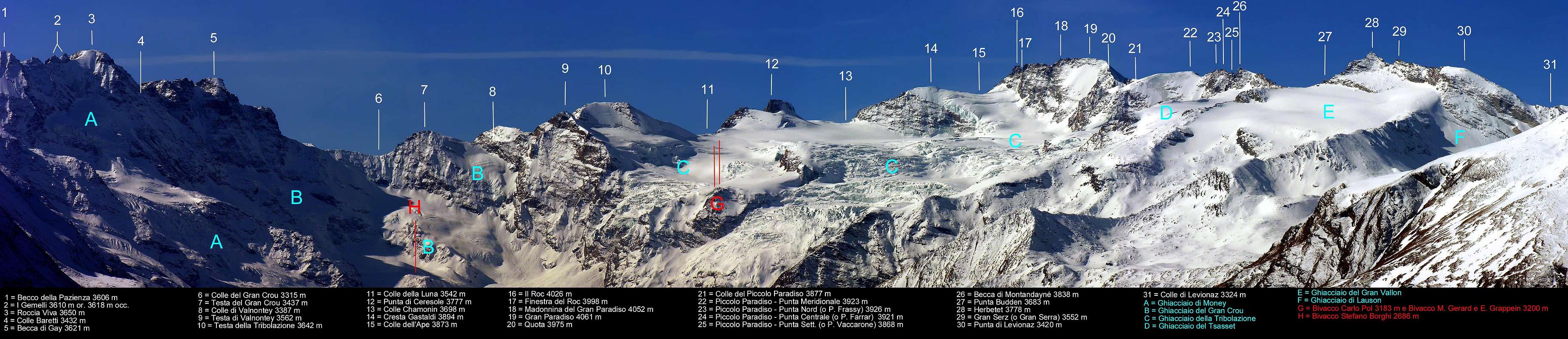
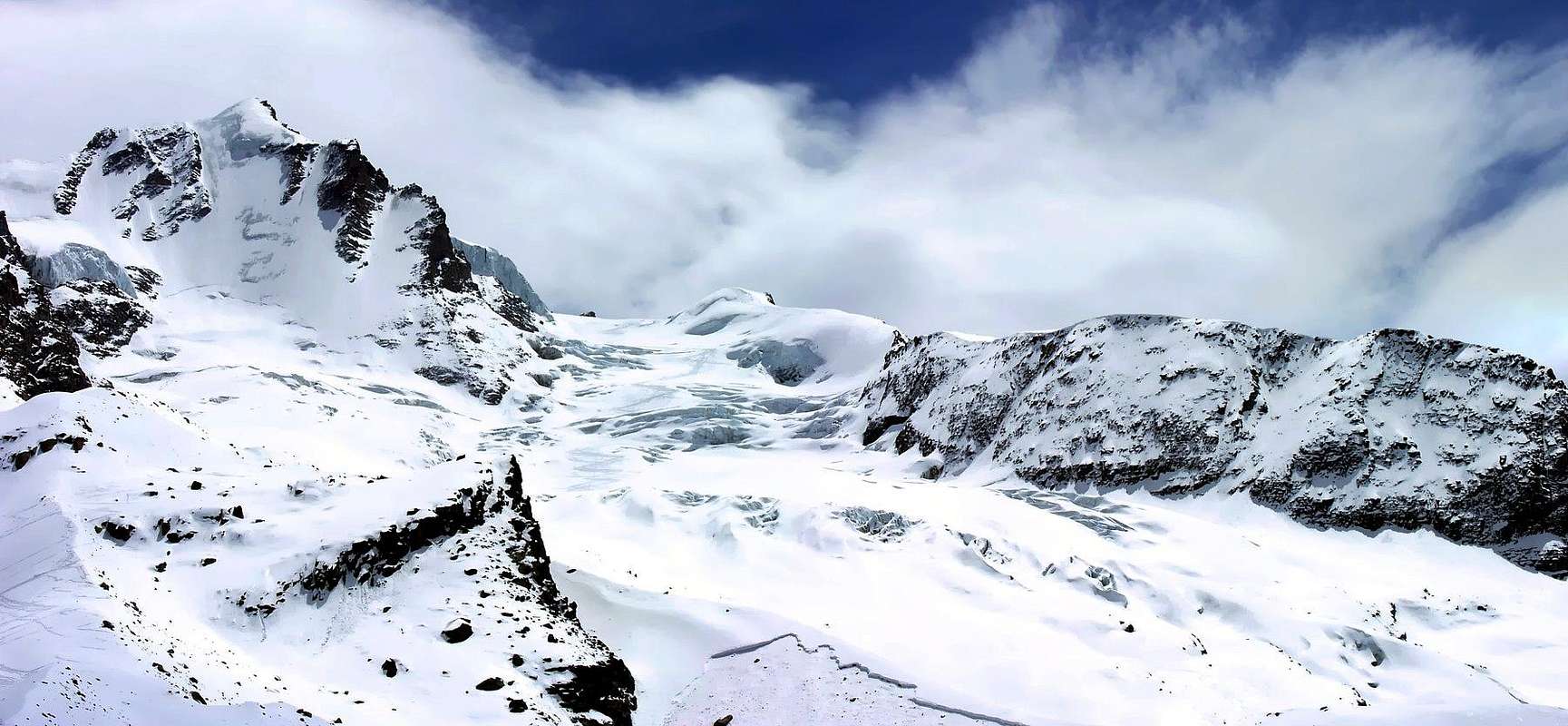
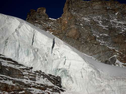
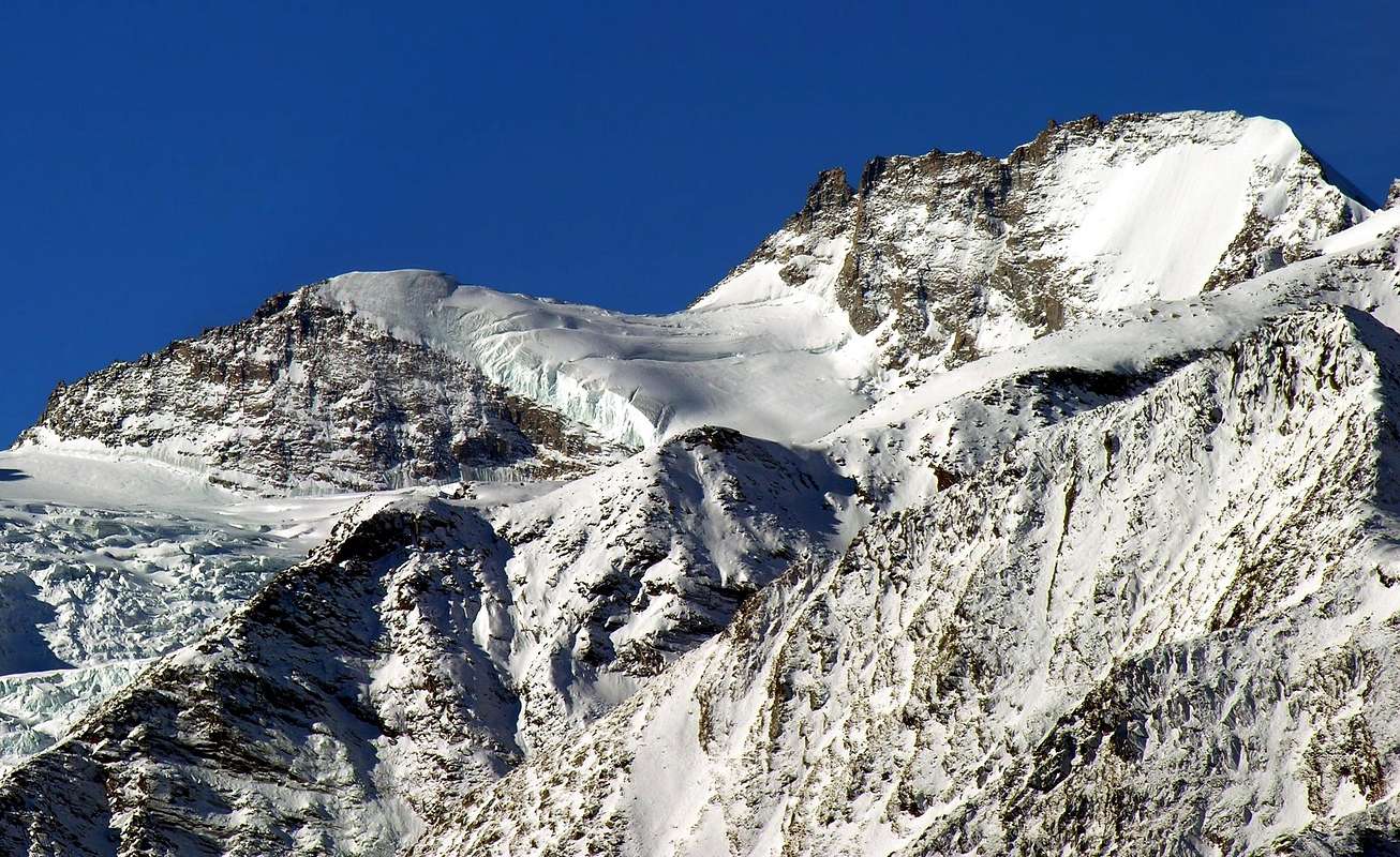
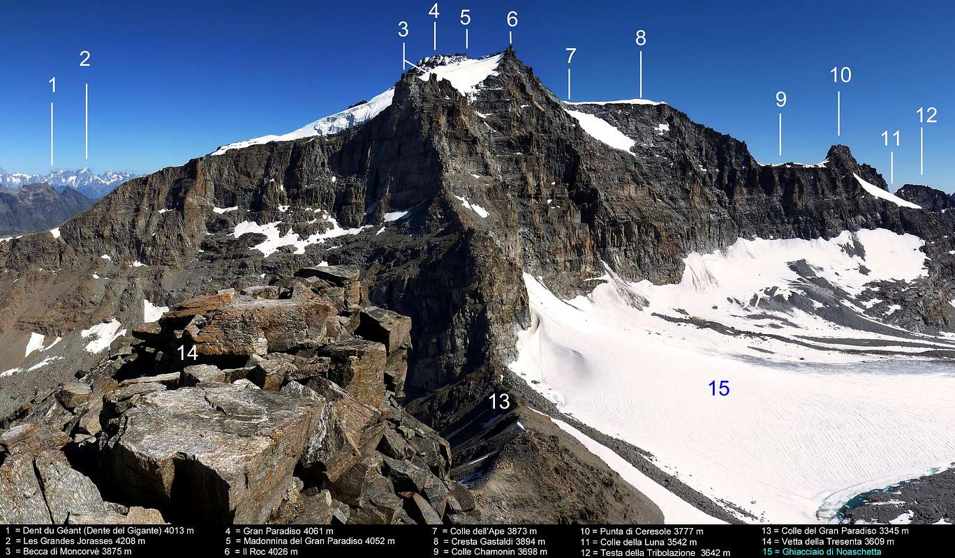
The GRAN PARADISO (4.061m) it is the apex of a big mountainous chain, that from the Monviso(3.841m) it extends him from Southeast to North toward the Chain of the Mont Blanc (4.811m), maximum Peak of Europe. As this last should be inserted in the Chain of the Graians Alps between the Cottian Alps and the Pennine Alps. Both the one and the other, for the importance of their peaks and for the great ampleness of busy territory, they come in all the alpine publications, as well as in the most famous guides of mountain, you treat as to it self stale. As it regards ours there is to say that it originates in narrow sense, with the motivations of which above from the Pass of the Arietta among the Valley of Cogne and the Vallone of St. Besso in the Valley Locana and it goes to finish in the great chain that from the Point of Galisia (3.346m; very important topographical knot among France, Piedmont and Valley of Aosta) it actually goes down perpendicularly toward North to the river Dora Baltea and fit to separate the alpine valleys of Valsavarenche (to East) and of the Valley of Rhêmes to Western. Considering for good the artificial division effected in the Necklace Drives some Mountains of Italy C.A.I./T.C.I. "Gran Paradiso Parco Nazionale" by Emanuele Andreis-Renato Chabod-Mario Carlo Saints in the 1939 various editions, 1963 and 1980 come "absorbed" also some layers of the tall Valley of the Isère up to the Cima d'Oin (3.278m), precente the homonym footstep and with exclusion therefore of the greatest mountainous subgroup that culminates in the Grande Aiguille Rousse (3.482m), inserted in the National Park of the Vanoise. From this point and verse If, the Valleys of Susa and the City of Turin the alpine area will be treated, always in the same necklace, from the Guide "Alpi Graie Meridionali" to work of Lino Fornelli and Giulio Berutto, in 1980, while the sector Northwest of the Central Alps Graie actually to the Pass of the Seigne, hands of entry to the Chain of the Blanc, he will be compiled by Alexander Giorgetta in 1985. Arbitrarily and purposely for reasons for space, as Chabod tells the beginning of her Preface in the 1939 edition, the GROUPs of Mount Emilius, Point Tersiva, Mount Glacier and Delà, Mount Avic and Rosa of the Banchi Summit or the whole area are pre-emptive excluded toward East or toward South toward the Central Valley of the Dora Baltea. As it regards the first one he will be published in 1978 one "Guida del Monte Emilius" from the author-publisher Osvaldo Cardellina, sectorial job that stops him to the Pass of Saint Marcel; she will be taken back and widened to the other lacking zones from Giulio Berutto-Lino Fornelli in the Guide C.A.I./T.C.I. "Emilius Rosa dei Banchi Parco del M. Avic", I edit in 2005. But coming to the Gran Paradiso, agreement as mountain in narrow sense there is to annotate as is forged in very particular way: not a pyramid or a slender top, not a crest jagged summital, not a "great bread" glacial, not a rocky buttress formed by numerous peaks, on the contrary some all of this, in a heap of rocks and ices I vary, variegated and complete, such to give the impression of a powerful person buttress that changes continuously its aspect, according to where you are admired her. Its real Peak should be considered along the longitudinal axle North/South the culminating point among the Pass of the Little Paradiso(3.877m) to North and the Roc of the Gran Paradiso(4.026m), small peak suffered to South; but the glacial layers of the Glacier of the Gran Paradiso, that they go down true South, and the great spur of the Pecks or "Becca" at of Moncorvé(3.875m) they make part of it to all the effects, so much that they constitute the standard route of slope of it. In sense East/West instead the mountain appears more "flattened": to East it falls on the Glacier of the Tribulation in the Valley of Cogne with the relative Wall E in ice of around 400 meters and, beginning from the square tower of the Roc, with a steep rocky great ridge above the Hill of the Ape and the Crest Gastaldi; toward West instead it is undoubled, separated in two from a great Crest W-NW that it sinks its roots inside the Glacier of Laveciaù. Its left side goes down with a splendid icy Wall NW intercalated by some rocky ribs of beautiful granite; that of right sinks wild with a seracs fall and rocks to form of "reeds of organ" in the superior part of the same glacier, where this goes to melt himself with that of the Gran Paradiso.
Il GRAN PARADISO (4.061 m) é l'apice di una grandissima catena montuosa, che dal Monviso (3.841 m) si estende da SE a NO verso la Catena del Monte Bianco (4.811 m), massima Vetta d'Europa. Come questo ultimo andrebbe inserito nella Catena delle Alpi Graie tra le Alpi Cozie e le Alpi Pennine. Sia l'una che l'altra, per l'importanza delle loro vette e per la grande ampiezza di territorio occupato, vengono in tutte le pubblicazioni alpinistiche, nonché nelle più famose guide di montagna, trattate come a sé stanti. Per quanto concerne il nostro vi é da dire che origina in senso stretto, con le motivazioni di cui sopra dal Colle dell'Arietta tra la Valle di Cogne e il Vallone di San Besso in Valle Locana e va a terminare nella grande catena che dalla Punta di Galisia (nodo topografico molto importante tra Francia, Piemonte e Valle di Aosta) scende perpendicolarmente verso N sino al fiume Dora Baltea ed atta a separare le valli alpine di Valsavarenche (ad E) e della Valle di Rhêmes ad Occidente. Tenendo per buona la divisione artificiale effettuata nella Collana Guida dei Monti d'Italia C.A.I./T.C.I. "GRAN PARADISO Parco Nazionale" di Emanuele Andreis-Renato Chabod-Mario Carlo Santi nelle varie edizioni del 1939, 1963 e 1980 vengono "assorbite" anche alcune propaggini dell'Alta Valle dell'Isère fino alla Cima d'Oin (3.278 m), precente l'omonimo passo e con esclusione quindi del più grande sottogruppo montuoso che culmina nella Grande Aiguille Rousse (3.482 m), inserito nel Parco Nazionale della Vanoise. Da questo punto e verso SE, le Valli di Susa e la Città di Torino l'area alpina verrà trattata, sempre nella stessa collana, dalla Guida "Alpi Graie Meridionali" ad opera di Lino Fornelli e Giulio Berutto, nel 1980, mentre il settore NO delle Alpi Graie Centrali sino al Colle della Seigne, porta di ingresso alla Catena del Bianco, sarà compilato da Alessandro Giorgetta nel 1985. Arbitrariamente e volutamente per ragioni di spazio, come dice Chabod all'inizio della sua Prefazione nell'edizione del 1939, vengono aprioristicamente esclusi i Gruppi del Monte Emilius, Punta Tersiva, Mont Glacier e Delà, Monte Avic e la Sommità della Rosa dei Banchi, ovvero tutte le area verso Oriente o verso Meridione verso la Valle Centrale della Dora Baltea. Per quanto concerne il primo sarà pubblicata nel 1978 una "Guida del Monte Emilius" da parte dell'autore-editore Osvaldo Cardellina, lavoro settoriale che si ferma al Colle di Saint Marcel; sarà ripreso ed ampliato alle altre zone mancanti da parte di Giulio Berutto-Lino Fornelli nella Guida C.A.I./T.C.I. "Emilius Rosa dei Banchi Parco del M. Avic", edito nel 2005. Ma venendo al Gran Paradiso, intesa come montagna in senso stretto, c'é da annotare come sia forgiata in modo molto particolare: non una piramide oppure una cima slanciata, non una cresta sommitale frastagliata, non un "panettone" glaciale, non un contrafforte roccioso formato da numerose vette, bensì un poco di tutto ciò, in un grande ammasso di rocce e ghiacci vario, variegato e completo, tale da dare l'impressione di un'unica potente bastionata cangiante sorprendentemente e di continuo il suo aspetto, a seconda di dove la si osservi e la si ammiri.La sua Vetta vera e propria dovrebbe essere considerato lungo l'asse longitudinale N/S il punto culminante tra il Colle del Piccolo Paradiso(3.877 m) a N ed il Roc del Gran Paradiso(4.026 m), piccola vetta subito a S; ma le propaggini glaciali del Ghiacciaio del Gran Paradiso, che scendono vero Meridione, e la grande bastionata della Becca di Moncorvé(3.875 m) ne fanno parte a tutti gli effetti, tanto che ne costituiscono la via normale di salita. In senso E/W invece la montagna appare più "appiattita": ad E cade sul Ghiacciaio della Tribolazione in Valle di Cogne con la relativa Parete E in ghiaccio di circa 400 metri ed, a partire dallo squadrato torrione del Roc, con un ripido cretone roccioso sopra il Colle dell'Ape e la Cresta Gastaldi; verso O invece si sdoppia, diviso in due da un grande Crestone W-NW che affonda le sue radici dentro il Ghiacciaio di Laveciaù. Il suo lato sinistro scende con una splendida Parete glaciale NW intercalata da alcune costole rocciose di bel granito; quello di destra sprofonda selvaggio con una seraccata e rocce a forma di "canne d'organo" nella parte superiore dello stesso ghiacciaio, dove questo va a fondersi con quello del Gran Paradiso.
Little HISTORICAL NOTES
* Gran Paradiso(4.061m) it is the situated tallest peak in the National Park of the Great Paradiso, natural reserve and l'only 4.000 metres exclusively placed in completely Italian territory. Anciently called Mont Iseran, such toponym to be represented the whole vast area understood between the Central Valley of the Dora Baltea and the Valley of the River Isère from the French side; the origin of the actual name, in top from the beginning of the 800 (for the first time brought by it "Papers Chorographique of a parties du Piemont et de the Savoie", Bulletin of the C.A.I. XXXIX, page 54), it results unknown. Other placenames of the epoch, with which identifying a hill, a pass, a peak, a glacier or an Episcopalian ownership, I am: Mountain of the Plot, Montandayné, Lausqueur, Lasqueor, the Lévesqueur, the Evesqueur, or of ownership of the Bishop, since in the antiquity they were the pastures, the waters and the woods that interested the inhabitants of the valleys and not certain the immaculate peaks, cosiderate thick cursed places ("maudits") for the dangerousness and the natural disasters that brought. At the end who knows that I he am not right the automatic translator when it recognizes it in Great Heaven or the Great Sky that it covers the immaculate ones, sparkling and svettanti tops of the Graian Alps in direction of the Lowland Padana (= of the Po River Tableland) and of the Sea.
* Il Gran Paradiso(4.061 m) è la vetta più alta situata nel Parco Nazionale del Gran Paradiso, riserva naturale, e l'unico 4.000 metri situato esclusivamente e completamente in territorio italiano. Chiamato anticamente Mont Iseran, toponimo tale da rappresentare tutta la vasta area compresa tra la Valle Centrale della Dora Baltea e la Valle del Fiume Isère dal lato francese; l'origine dell'attuale nome, in auge dall'inizio dell'800 (per la prima volta riportato dalla "Carte Chorographique d'une partie du Piemont et de la Savoie", Bollettino del C.A.I. XXXIX, pagina 54), risulta sconosciuto. Altri nomi dell'epoca, con i quali identificando un promontorio o collina, un colle, una vetta, un ghiacciaio oppure una proprietà vescovile, sono: Monte del Broglio, Montandayné, Lausqueur, Lasqueor, l'Lévesqueur, l'Evesqueur, ovvero di proprietà del Vescovo, poiché nell'antichità erano i pascoli, le acque ed i boschi che interessavano e non certo le vette immacolate cosiderate spesso luoghi maledetti ("maudits") per la pericolosità e le catastrofi naturali che portavano. Alla fine chissà che non abbia ragione il traduttore automatico quando lo riconosce in Great Heaven, ovvero il Grande Cielo che ricopre le immacolate, scintillanti e svettanti cime delle Alpi Graie in direzione della Pianura Padana e del mare.
** Gran Paradiso National Park, natural reserve, is one of the oldest natural reserves in Europe: the area has been protected since 1821, at the initiative of Joseph Zumstein, and with the approval of the house of Savoie, rulers of Piemonte. Vittorio Emanuele II was 1 year old at the time. He not only first became king of Sardinia-Piedmont, and in 1861 the first king of the united Italy, he was also a very keen hunter who used the area as his private hunting domain. After his death in 1878, he was succeeded by his son Umberto I, and, after the latter was assassinated in 1900, by his grandson Victor Emmanuel III, who resigned from office in 1946 when Italy became a republic. It was Victor Emmanuel III, not much into hunting, who handed the area over to the Italian state in 1922, which made it into Italy first national park.
** Il Parco Nazionale del Gran Paradiso risulta essere una delle riserve naturali più vaste dell'intera Europa: l'area viene protetta dal 1821, in base all'iniziativa del Naturalista Giuseppe Zumstein e grazie all'approvazione di Casa Savoia, regale casa piemontese. Vittorio Emanuele II° era in carico da un anno. Re dello Stato di Piemonte e Sardegna nel 1851 fu incoronato qual primo Re d’Italia; cacciatore molto appassionato ed esperto organizzò numerose battute di caccia utilizzando la regione del Gran Paradiso come regal area privata. Dopo la sua morte, avvenuta nel 1878, fu succeduto dal figlio primogenito Principe Umberto di Savoia e, dopo l'assassinio di questo ultimo, avvenuto nel 1900, dal nipote il quale prese il nome di Vittorio Emanuele II°. Questi si dimise dall'incarico, allorché nel 1946 l'Italia si trasformò con plebiscito popolare da monarchia in repubblica. E fu proprio lui, non molto predisposto alla caccia, a donare in modo definitivo l'area allo Stato Italiano; questi nel 1922 lo trasformò istituendolo quale primo Parco Nazionale d'Italia.
*** The park was enlarged in 1979, and now it covers an area of 70.000 ha. It borders the Parc National de la Vanoise, the first national parc of France (founded in 1963) and with 53.000 ha slightly smaller than its Italian counterpart. It partially covers currently the tall part of the Valley of the Orco/Locana/Ceresole Reale in Piedmont; while on the sector of the Valley of Aosta it involves part of the Valley of Cogne (area of The Grivola, Vallone of the Pousset, Valnontey, Valeille, Vallone of Bardoney and the part left orographical of the Vallone of the Urtier in South of the homonym stream), the whole Valsavarenche and the in general right idrographic of the Valley of Rhemes, to East of the homonym one Dora (= Stream).
*** Il parco fu allargato nel 1979; al momento attuale copre un'area di 70.000 ettari. Confina con il Parco Nazionale della Vanoise, primo parco nazionale della Francia (fondato nel 1963) che con i suoi 53.000 ettari risulta lievemente più piccolo del nostro in causa. Attualmente ricopre parzialmente la parte alta della Valle dell'Orco/Locana/Ceresole Reale in Piemonte; mentre sul settore della Valle di Aosta coinvolge parte della Valle di Cogne (area della Grivola, Vallone del Pousset, Valnontey, Valeille, Vallone di Bardoney e la parte orografica sinistra del Vallone dell'Urtier a Meridione dell'omonimo torrente), 'l'intera Valsavarenche ed il lato idrografico destro della Valle di Rhemes, ad E dell'omonima Dora.
History and First Ascent
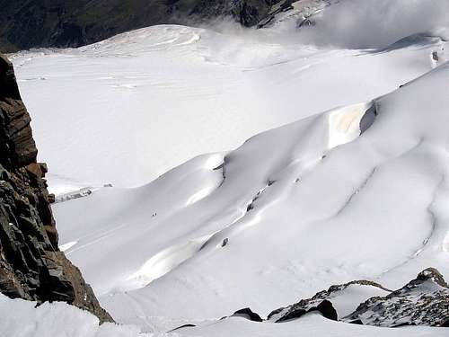
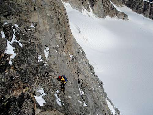
The first absolute ascension of the mountain happened the 4 Sep of 1860, to work of the guides of Chamonix Michel Payot and Jean Tairraz, with the two clients English John J. Cowell and Wuilliam Dundas; the same climbed for the Slope SW departing from the Alp of Moncorvé (2.426m) and they followed a street that him far few from the actual one by standard. The first winter ascension of the mountain happened for worth of the Biella Town Vittorio Sella and of the English S. Aitken accompanied by the famous and renowned guides of Valtournenche Jean Joseph and Daniel Maquignaz, on Mar 02th, 1885 and always in the same route. The first winter traverse in the sense NE/SW (big beautiful enterprise!) he was taken place the 09 February of 1925 from Miss E. Della Valle of Casanova, Umberto Balestrieri, Erasmo Barisone, I. Brosio and Ugo of Vallepiana; departing from the Farms of the Herbetet (2.441m), they reached the Glacier of the Tribulation, they climbed through the Finestra (= "Window") of the Roc (3.998m) and they concluded in Peak to the Great Paradiso, after an impressive marathon above all considering the fact to have been finished in i suffer winter, through the Glacier of the Gran Paradiso, in his final part. The descent happened for the normal street toward the Shelter Vittorio Emanuele II° and Pont (1.960m), so also completing the first winter crossing between the Valley of Cogne and that of Valsavarenche transiting for the maximum Peak. And' a run that anchors today leaves surprised and it makes to consider of what tempering they were the mountain climber of the other epoch or classical. Men and... girls! Other similar enterprises are those completed by the English J. P. Farrar (the Central Point of the Little Paradiso brings the name of it) with the guides Daniel Maquignaz and J. Koderbacher Junior, of which Aug 13th, 1898 didn't find better whether to cross the whole Northern Buttress departing from the peak and crossing so the Little Paradiso, Pecks at her of Montandayné also "Becca" (3.838m), the Point Budden to conclude on the splendid pyramid of The Herbetet. The itinerary was repeated, but in opposite sense, Sep 22th, 1929 from Luigi Bon and Renato Chabod, which departed however "only" from the Bonney Pass (3.587m); other mentions for G. Pollastri and the two guides of Valsavarenche E. and A. Dayné that Aug 30/31th, 1930 in inverse sense and with bivouac out to the "Window" of Tsasset (3.673m) they also crossed the Herbetet completing so the integral crossing up to the Necks of the Herbetet (3.355m and 3.267m), by a test worthy of a camels. Other crossing Herbetet/Gran Paradiso that of Luigi Revelli and Henry Vassallo Aug 14/15th 1940, with I camp out on he Pecks at her of Montandayné, while in opposite sense they climb Jul 26/27th, 1947, with I camp out on the Forked Tower on the beautiful and difficult Herbetet Crest S. Through these great crossings and with the first beginning of the after war a gold epoch concludes him that sees to the work great mountain climbers of wrist of the classical mountaineering. As it regards all the other routes, besides the Via Amilcare Crétier, Luigi Bon and Renato Chadod of Jul 11 and that of the NW Wall - You see to the respect "All Northern Routes" in SP - and the E Face, by the two mountain guides of Cogne P. G. Frassy and Eliseo Jeantet on Sep 15th, 1869 (historical and important since they concern the two most beautiful icy faces from the Valsavarenche, and more in seen by Cogne, of the mountain), the most abundant contained underlying treatment is postponed to in the sundry "Approaches", with relative "Possible Routes", as well as in the "Standard Routes", with departures from the two huts and from the three bivouacs existing to the feet of the Gran Paradiso.
La prima ascensione assoluta della montagna avvenne il 4 Settembre del 1860, ad opera delle guide "chamoniarde" Michel Payot e Jean Tairraz con i due clienti inglesi John J. Cowell e Wuilliam Dundas; gli stessi salirono per il Versante SW partendo dall'Alpe di Moncorvé (2.426 m) e seguirono una via che si discosta poco dall'attuale via normale. La prima ascensione invernale della montagna avvenne per merito del biellese Vittorio Sella e dell'inglese S. Aitken accompagnati dalle famose e rinomate guide di Valtournenche Jean Joseph con Daniel Maquignaz, il 2 Marzo 1885 e sempre lungo la stessa via. La prima traversata invernale nel senso NE/SW (gran bella impresa!) venne compiuta il 9 Febbraio del 1925 da parte della signorina E. Della Valle di Casanova, Umberto Balestrieri, Erasmo Barisone, I. Brosio ed Ugo di Vallepiana; partendo dai Casolari dell'Herbetet (2.441 m) raggiunsero il Ghiacciaio della Tribolazione salirono guadagnando la cresta spartiacque attraverso la Finestra del Roc (3.998 m) e conclusero in Vetta al Gran Paradiso, dopo una maratona impressionante soprattutto considerando il fatto di essere stata compiuta in pieno inverno, tramite il Ghiacciaio del Gran Paradiso nella sua parte finale. La discesa avvenne per la via normale verso il Rifugio Vittorio Emanuele II° e Pont (1.960 m), compiendo così anche la prima traversata invernale tra la Valle di Cogne e quella di Valsavarenche transitando per la Vetta massima. E' una corsa che ancora oggi lascia di stucco e fa considerare di che tempra fossero gli alpinisti dell'altra epoca o classica. Uomini e... signorine! Altre imprese similari sono quelle compiute dall'inglese J. P. Farrar (la Punta Centrale del Piccolo Paradiso ne conserva ai posteri la memoria) con le guide Daniel Maquignaz e J. Koderbacher Junior, i quali il 13 Agosto 1898 non trovarono di meglio che percorrere l'intero Contrafforte Settentrionale partendo dalla vetta ed attraversando così il Piccolo Paradiso, la Becca di Montandayné (3.838 m), la Punta Budden per concludere sulla splendida piramide dell'Herbetet. L'itinerario venne ripetuto, ma in senso opposto, il 22 Settembre 1929 da Luigi Bon e Renato Chabod, prendendo le mosse però "solo" dal Col Bonney (3.587 m); altre degne menzioni per G. Pollastri e le due guide di Valsavarenche E. ed A. Dayné che il 30/31 Agosto 1930, in senso inverso e bivaccando alla Finestra di Tsasset (3.673 m), attraversarono anche l'Herbetet compiendo così una grande e splendida traversata integrale fino ai Colli dell'Herbetet (3.355 m e 3.267 m), con una prova degna di un cammello. Altra traversata Herbetet/Gran Paradiso quella di Luigi Revelli ed Enrico Vassallo il 14/15 Agosto 1940, con bivacco sulla Becca di Montandayné, mentre in senso opposto salgono il 26/27 Luglio 1947, con bivacco sulla Torre Bifida sulla bella e difficile Cresta S dell'Herbetet. Con queste grandi traversate e con il primo inizio del dopo guerra si conclude un'epoca d'oro, tale da vedere all'opera grandi alpinisti, e di polso, dell'alpinismo classico. Per quanto concerne tutte la altre vie, oltre alla Via Amilcare Crétier, Luigi Bon e Renato Chadod del 11 Luglio sulla grande Parete NO - Vedi inoltre al proposito "All Northern Routes" in SP - e quella della Parete E da parte delle due guide di Cogne P. G. Frassy ed Eliseo Jeantet del 15 Settembre 1869 (storiche ed importanti poiché concernenti le due facce glaciali più belle dalla Valsavarenche, e più in vista da Cogne, della montagna), si rimanda alla più che abbondante trattazione a venire, contenuta nei varii "Approachs" con relative "Vie Possibili", nonché nelle "Standard Routes" con partenze dai due rifugi e dai tre bivacchi esistenti ai piedi del Gran Paradiso.
The VIRGIN MARY of the SUMMIT: the little statue of The Virgin Mary (= "Madonna" in Italian language) on the peak is situated there since Jul 04th, 1954, when Alpin Guides, alpinists, and priests ascient the highest 4.000 meters situated only in the italian territory. The alpinist-priest "Don Pierino Balma" is one of the promoter of the project. The "Madonna" was recently restaured in Florence.
La MADONNINA della VETTA del GRAN PARADISO: la statua della Madonnina sin dal 04 Luglio 1954, allorché guide alpine, alpinisti e preti la posizionarono sul più elevato dei 4.000 metri italiani ed il solo in esclusivo territorio. Il prete-alpinista "Don Pierino Balma" ne fu uno dei primi promotori, mentre la Madonna attualmente posizionata in Vetta é stata recentemente restaurata a Firenze.
Getting there
The routes to refuges Vittorio Emanuele and refuge Chabod start from Pont Valsavaranche (1.960m). You can left your car in a free parking area, just at the begin of the path to refuge Vittorio Emanuele II.
APPROACHS to and from Vittorio Emanuele I° (Old and New) and Renato and Federico Chabod Refuges (Valsavarenche Valley)
* REMARK: the ascent to Routes of the Gran Paradiso is generally done in two stages, both as it regards the slope of the Aosta Valley (Valley of Valsavarenche, through departure from great Parking of Pont Valsavarenche (1.960m) to Vittorio Emanuele I° Old and New Refuges and, by start from fork 1.829m, to the most recent Renato and Federico Chabod Shelter; Cogne Valley, with departure from Valnontey Village (1.666m) to Lionello-Lucio Leonessa, Carlo Pol, Marcello Gérard-Ettore Grappein Bivouacs) that of Piedmont slope of the mountain (Valleys of Locana and small Vallone of Noaschetta, from Noasca Village (1.058m) to Ivrea Bivouac).
A) -first day: departing beforehand of Pont Valsavarenche (alternative 1.829m, with small parking lot in earth, immediately afterwards the Camping Great Paradiso), and supporting itself to the Shelter Renato and Federico Chabod (2.810m). The ascent happens through the path n° 5/5A/10A and by a diagonal with direction to if passing for the Praviou Alp (1.869m); from this, reversing twice the rout in Northeast and, after having left on the left a brief deviation to blind fund, the following Alp of Lavassey it is reached (2.194m).
VARYING: to Abandon (or to cross this itinerary with a run inusuale) this direction of march that continues with the path n° 5A toward the Montandayné Pastures (2.463m) and that however, with a breadth turn Northern and hemi circular, it also comes near the Shelter Chabod, to quota 2.759m (in this case to calculate 0h'30 in more). To again continue instead toward Southeast and, first with a brief diagonal, then to fury of hairpin bends, dominating as soon as from above the Torrent Coast Savatere and passing for the quotas 2.246m, 2.414m. Between this last and the following 2.506m to abandon on the right (South) the deviation unnumbered for the of Laveciaù Pastures (2.456m), sets to the bese of the homonym glacier, and to transit instead under the homonym rocky coastline (2.575m). Through a last and longer diagonal toward East, with which the mule-track touches the stream, and a short gone up again final toward North and with a general gradient of around 900 meters. the Renato and Federico Chabod Hut is reached (E; 1h'30/2h'00).
A) - on the second day: ITINERARY through:
1) - From Renato and Federico Chabod Hut to Montandayné Pass (3.718m);
2) - From Renato and Federico Chabod Hut to Piccolo Paradiso Pass (3.877m);
3) - From Renato and Federico Chabod Hut through the Laveciaù also called Lavecciau Glacier and by the "Schiena d'Asino" or "Hogback"(3.750m);
POSSIBLE ROUTES from left or Northern to Western-southwestern:
a) - Standard Route by connection between Laveciaù Glacier, the "Schiena d'Asino or Hogback" and through link with the Normal Route or "Via Traditional" from Vittorio Emanuele I° Refuge and SW Slope, in terminal part; it consists and it coincides with the, in terminal part from "Schiena d'Asino" to Summit, Route of the First mountaineers of the mountain (J. J. Cowel-W. Dundas, with the mountain guides of Chamonix Michel Payot and Jean Tairraz, on Sep 04th, 1860) moving from the Moncorvé Alp, reached the Summit of the Great Paradiso, without logically transiting from the Shelter Emanuele, then nonexistent;
b) - through the Laveciaù Glacier, the Upper Plateau of Gran Paradiso Glacier and the "Canne d'Organo-Organ Pipes" Route of the W-SW Face, by G. Bertotti-A. Tardito on 1967;
c) - Great W-NW Ridge and Variants; (to see with regard to "All Northern Routes of Gran Paradiso" always in SP);
d) - all routes of the NW Face and in particular the Crétier-Bon-Chabod Route of 1930 and the route entirely in ice on the face, by Corrado Bertolone and Company on 1958 (see with regard to "All Northern Routes of Gran Paradiso" always in SP);
e) - Gran Paradiso, by N-NE Crest, from Piccolo Paradiso Pass (see with regard to "All Northern Routes of Gran Paradiso" always in SP);
f) - all routes of the W Wall of Piccolo Paradiso or, from right and from the Southern two Points also called P. G. Frassy Point: Frassy-Jeantet Route of 1969, Eugène Bron and Company of around 1950; to Central Point also J. P. Farrar: by the W-NW Spur and the W Wall or E. BacKhouse-M. J. Chabod-A. A. Dayné Route on 1908; to Northern Point also Luigi Vaccarone Point: through the W Face, the NW Edge and N Crest in terminal part or L. Vaccarone-A. Castagneri-A. Boggiatto Via of 1875;
g) - by the NW Edge and N Crest in final part of the Little Paradiso or Via P. Filippi-A. Dayné of 1925;
h) - through the Hanging Glacier of Laveciaù, by the N Face of the Piccolo Paradiso or Viano-G. Giovetto-G. Miglio-G. Viano Route on 1960;
i) - Great Traverse from Montandayné Pass crossing the Piccolo Paradiso (see with regard to "All Northern Routes of Gran Paradiso" always in SP).
* NOTA: tutte le vie del Gran Paradiso vengono generalmente percorse in due giorni, sia per quanto concerne il versante valdostano (Valsavarenche prendendo le mosse dal grande Parcheggio di Pont Valsavarenche (1.960 m) per i Vittorio Emanuele I° Rifugi Vecchio e Nuovo e con partenza dal bivio 1.829 m in direzione del più recente Rifugio Renato e Federico Chabod; Valle di Cogne avviandosi dal Villaggio di Valnontey (1.666 m) verso i Bivacchi Lionello-Lucio Leonessa, Carlo Pol, Marcello Gérard-Ettore Grappein) che quello piemontese della montagna (Valli di Locana e piccolo Vallone di Noaschetta, che, partendo dal Villaggio di Noasca (1.058 m), adduce al Bivacco Ivrea).
A)-primo giorno: partendo da prima di Pont Valsavarenche (bivio 1.829 m con piccolo parcheggio in terra, subito dopo il Camping Gran Paradiso), ed appoggiandosi al Rifugio Renato e Federico Chabod (2.810 m). La salita avviene tramite il sentiero n° 5/5A/10A e con un diagonale con direzione a SE passante per l'Alpe Praviou (1.869 m); da questa, invertendo due volte la rotta in NE e, dopo aver lasciato sulla sinistra una breve deviazione a fondo cieco, si raggiunge la successiva Alpe di Lavassey (2.194 m).
VARIANTE: Abbandonare (oppure percorrere questo itinerario con un percorso inusuale) questa direzione di marcia che continua con il sentiero n° 5A verso l'Alpeggio di Montandayné (2.463 m) e che comunque, con un largo giro semicircolare a Settentrione, pur esso giunge nei pressi del Rifugio Chabod, a quota 2.759 m (in questo caso calcolare 0h'30 in più). Continuare invece nuovamente verso SE e, prima con un breve diagonale, poi a furia di tornanti, dominando appena da sopra il Torrent Cote Savatere e passando per le quote 2.246 m, 2.414 m. Tra questa ultima e la successiva 2.506 m abbandonare sulla destra (S) la deviazione non numerata per gli Alpeggi di Laveciaù (2.456 m), posti alla bese dell'omonimo ghiacciaio, e transitare invece sotto l'omonima costiera rocciosa (2.575 m). Con un ultimo e più lungo diagonale verso E, con il quale la mulattiera tocca il torrente, ed una breve risalita finale verso N e con un dislivello complessivo di circa 900 metri si raggiunge il Rifugio Renato e Federico Chabod (E; 1h'30/2h'00).
A) - nel secondo giorno: ITINERARI tramite:
1) - Dal Rifugio Renato e Federico Chabod al Colle di Montandayné (3.718 m);
2) - Dal Rifugio Renato e Federico Chabod al Colle del Piccolo Paradiso (3.877 m);
3) - Dal Rifugio Renato e Federico Chabod tramite il Ghiacciaio di Laveciaù o Lavecciau e la Schiena d'Asino (3.750 m).
VIE FATTIBILI iniziando dalla sinistra o Settentrione e verso W-SW:
a) - Via Normale collegando il percorso tra Ghiacciaio di Laveciaù, la "Schiena d'Asino", collegamento con la Via Tradizionale proveniente dal Rifugio Vittorio Emanuele I° ed il Versante SW, nel tratto finale; consiste e coincide nella parte finale, dalla "Schiena d'Asino" alla Vetta, con la Via dei Primi salitori della montagna (J. J. Cowel-W. Dundas, con le guide di Chamonix Michel Payot e Jean Tairraz, il 04 Settembre, 1860) che, prendendo le mosse dall'Alpe di Moncorvé, raggiunsero la Sommità del Gran Paradiso senza transitare logicamente dal Rifugio Emanuele, allora inesistente;
b) - Ghiacciaio di Laveciaù, il Plateau Superiore del Ghiacciaio del Gran Paradiso e la Via delle "Canne d'Organo" sul Versante W-SW, da parte di G. Bertotti-A. Tardito nel 1967;
c) - Gran Crestone W-NW e Varianti (al riguardo vedi "All Northern Routes of Gran Paradiso" sempre in SP);
d) - tutte le vie della Parete NW ed in particolare la Via Crétier-Bon-Chabod del 1930 e la via interamente glaciale e completa della parete di Corrado Bertolone e Compagni nel 1958 (al riguardo vedi "All Northern Routes of Gran Paradiso" sempre in SP);
e) - Gran Paradiso per la Cresta N-NE dal Colle del Piccolo Paradiso (al riguardo vedi "All Northern Routes of Gran Paradiso" sempre in SP);
f) - tutte le vie sulla Parete O del Piccolo Paradiso ovvero, partendo da destra e dalle Punte Meridionali o Punta P. G. Frassy: via Frassy-Jeantet del 1969, Via Eugène Bron del 1950 circa; alla Punta Centrale o J. P. Farrar: per lo Sperone O-NO e la Parete O o Via E. Backhouse-M. J. Chabod-A. A. Dayné del 1908; alla Punta Settentrionale o Punta Luigi Vaccarone: per la Parete O, lo Spigolo NO e la Cresta N nella parte finale, o Via L. Vaccarone-A. Castagneri-A. Boggiatto del 1875;
g) - per lo Spigolo NO e, nel tratto terminale, per la Cresta N del Piccolo Paradiso o Via P. Filippi-A. Dayné del 1925;
h) - tramite il Ghiacciaio Sospeso di Laveciaù e per la Parete N del Piccolo Paradiso o Via V. Viano-G. Giovetto-G. Miglio-G. Viano del 1960;
i) - Grande Traversata dal Colle di Montandayné scavalcando il Piccolo Paradiso al riguardo vedi "All Northern Routes of Gran Paradiso" sempre in SP).
B) - even using the two (Old and New) Vittorio Emanuele I° Refuges, the all ascents to Northern Routes of the Gran Paradiso is usually done in two stages: on the first day you follow the normal route to Gran Paradiso and gain 770m~ of elevation from Pont (1.960m) to two Refuges Vittorio Emanuele (2.734m) and (2.745m). From great ground park, nearby the Camping Pont-Breuil 1.952m) cross the Savara Stream (abounding signs and panneaux for the path n° 1) through a wooden bridge and, by South direction and along the same torrent, continue as far as the 1.991m pasture, in renovation stage; doubling this in right go up on upper promontory by dint of hairpin bends and cross over the Chanté Alp (2.372m, ruins). Through a final diagonal overcome the about 770 meters difference in level reaching the two huts (E; 1h'15/2h'00).
B) -: on the second day: ITINERARY through:
1) - From two Vittorio Emanuele I° Shelters directly to "Schiena d'Asino or "Hogback"(3.750m) and by the SW Slope also Standard Route to Summit (4.061m);
2) - From two Vittorio Emanuele I° Huts to of the Gran Paradiso Pass (3.345m);
POSSIBLE ROUTES from left or Northwestern to Southwestern:
a) - all routes of the NW Face and in particular the Crétier-Bon-Chabod Route of 1930, the route entirely in ice on the face, by Corrado Bertolone and Company on 1958 and Ugo Manera-P. Rossetti Route (of the Seracs or Super Direct Route, on 1974; see with regard to "All Northern Routes of Gran Paradiso" always in SP);
b) - Great W-NW Ridge and two Variants; (to see with regard to All Northern Routes of Gran Paradiso" always in SP);
c) - through the Gran Paradiso Glacier, the Upper Plateau of Gran Paradiso Glacier and the "Canne d'Organo - Organ Pipes" Route of the W-SW Face, by G. Bertotti-A. Tardito on 1967;
d) - for the Buttress of Moncorvé and between the Glaciers of the Gran Paradiso and of Laveciaù, the "Back of Donkey" and the Slope SW or Route Maria Andreis-Emanuele Andreis-Renato Chabod, in 1936; Varying to the normal Street that from the Shelter Emanuele directs him toward N long moraines reaching the quota 3.302m, for then to cross the whole ridge. Less banal than the Standard one and also more panning allowing the sight on two slopes of the mountain, but also very rarely follows;
e) - Normal Route through links by lower part of the Great Paradiso Glacier, the "Schiena d'Asino", the Plateau of Becca Moncorvé and by the SW Slope, in final part; it consists and it coincides with the Street of the First mountaineers of the mountain (J. J. Cowel-W. Dundas, with the mountain guides of Chamonix Michel Payot and Jean Tairraz, on Sep 04th, 1860) moving from the Moncorvé Alp, reached the Summit of the Great Paradiso, without logically transiting from the Shelter Emanuele, then nonexistent;
f) - from the Glacier of Moncorvé through the Great Ledge of the Moncorvé Great Spur, a small rocky spur connecting himself to the Normal Route toward the 3.200m; street crossed by R. Pendlebury-A. Cust-C. Taylor, with the mountain guides G. Spechtenhauser, J. Spechtenhauser e G. Blanchetti, in 1875; it deals with a variation more useful to whom originates from the Vallone of Noaschetta through the of Moncorvé or of the Great Paradiso Pass, that not to who part from the Hut Vittorio Emanuele I°, even if from this last it is feasible and she can constitute an amusing variation;
g) - for the Great Buttress of Moncorvé, reaching to around 3.500m the Normal Route or Via Michele Baratono-Federico Chabod, in 1919; non simple street that from the big alluvial cone, and nearby the preceding route, through a small channel, a rocky edge and of the slabs of rock in the final part, i crossed to the right by left (East), hands on the Standard Route, near the least elevated part of the "Hogback";
h) - by the SW Pillar of the Punta Marco (3.649m), the "Schiena d'Asino" and the Standard Route of the SW Slope also Via R. Bianco-Ugo Manera, of 1974, and dedicate to Marco Pocchiola of Turin Section of the Italian Alpine Club;
i) - by direct for the great Wall S of the Spur of underlying Moncorvé the quota 3.704m, between the Marco Point and the Moncorvé "Becca"; simple but rather rustic via not and exposed, to the actual state, to the fall of seracs from the higher glacial wall of Moncorvé. Realized by Luigi Saletti-P. Martinengo-Don Piero Solero, together with three young people to us strangers, in 1938; probably more repeated, also for the dangerousness accented him with to spend some years;
l) - by the various routes of the SW Wall of Moncorvé Becca and through the terminal part of the SW Slope: Via Mario Borgarello-Arno De Monte-Luigi Notdurfter of 1939;
m) - by the various routes of the SW Wall of Moncorvé Becca (3.875m) and through the terminal part of the SW Slope: C. Barbi-M. Salasco Route, on 1954;
n) - by the various routes of the SW Wall of Moncorvé Becca and through the terminal part of the SW Slope: Fausto Lorenzi-G. Bonetti-N. Gasser Direct Route also "Via degli Alpini", in memento of Ilario Antonio Garzotto and Gianni Junod, of 1971;
o) - from of Great Paradiso Pass, by the S Edge of Moncorvé Becca or Maria Sbrojavacca-Aldo Bonacossa Route of 1921 and collection with the Standard Route through the SW Slope;
p) - from Gran Paradiso Pass entirely and integrally in S Edge of Moncorvé Becca also Josve Aiazzi-Andrea Oggioni Route of 1955 and final link with the Normal Via on SW Slope.
B) - anche utilizzando i due rifugi (Vecchio e Nuovo) Vittorio Emanuele I°, tutte le vie dei versanti del Gran Paradiso vengono generalmente percorse in due giorni partendo da Pont Valsavarenche (1.960 m) ed appoggiandosi agli stessi: nel primo giorno partendo dal grande parcheggio in terra battuta, vicino al Camping Pont-Breuil (1.952 m), con direzione S si sale dapprima con la Mulattiera Reale lungo il Torrente Savara (abbondanti segnalazioni e pannelli indicanti il sentiero n° 1) doppiando a sinistra l'Alpeggio 1.991 m, in fase di ristrutturazione; poi superando il soprastante promontorio, a furia di tornanti, passando sopra l'Alpeggio diroccato di Chanté (2.372 m) e con un diagonale finale, si vincono i 770~ metri di dislivello raggiungendo i due rifugi (2.734 m e 2.745 m); E; 1h'15/2h'00).
B) - nel secondo giorno ITINERARI tramite:
1) - Dai due Rifugi Vittorio Emanuele I° direttamente alla Schiena d'Asino (3.718 m) e per il Versante SW o via Normale alla Vetta (4.061 m);
2) - Dai due Rifugi Vittorio Emanuele I° al Colle del Gran Paradiso (3.345 m);
VIE FATTIBILI iniziando dalla sinistra o NW ed in direzione di SW:
a) - tutte le vie della Parete NW ed in particolare la Via Crétier-Bon-Chabod del 1930, la via interamente glaciale e completa della parete di Corrado Bertolone e Compagni nel 1958 e la Super Diretta o Via dei Seracchi di Ugo Manera-P. Rossetti, nel 1974 (al riguardo vedi "All Northern Routes of Gran Paradiso" sempre in SP);
b) - Gran Crestone W-NW e le due sue Varianti (al riguardo vedi "All Northern Routes of Gran Paradiso" sempre in SP);
c) - collegamento tra la parte inferiore del Ghiacciaio del Gran Paradiso, la "Schiena d'Asino", il Plateau Superiore del Ghiacciaio del Gran Paradiso e la Via delle "Canne d'Organo" sul Versante W-SW, da parte di G. Bertotti-A. Tardito nel 1967;
d) - per il Contrafforte di Moncorvé e tra i Ghiacciai del Gran Paradiso e di Laveciaù, la Schiena d'Asino e il Versante SW o Via Maria Andreis-Emanuele Andreis-Renato Chabod, nel 1936; variante alla Via normale che dal Rifugio Emanuele si dirige verso N lungo morene raggiungendo la quota 3.302 m per poi percorrere tutto il crinale. Meno banale della Normale ed anche più panoramica permettendo la vista su due versanti della montagna, ma anche molto raramente seguita;
e) - Via Normale collegando il percorso tra la parte inferiore del Ghiacciaio del Gran Paradiso, la "Schiena d'Asino", il Plateau della Becca di Moncorvé ed il Versante SW, nel tratto finale; consiste e coincide nella parte finale, dalla "Schiena d'Asino" alla Vetta, con la Via dei Primi salitori della montagna (J. J. Cowel-W. Dundas con le guide di Chamonix Michel Payot e Jean Tairraz, il 04 Settembre, 1860) che, prendendo le mosse dall'Alpe di Moncorvé, raggiunsero la Sommità del Gran Paradiso senza transitare logicamente dal Rifugio Emanuele, allora inesistente;
f) - dal Ghiacciaio di Moncorvé attraverso la Grande Cengia della Bastionata di Moncorvé, un piccolo sperone roccioso ricollegandosi alla Via Normale verso i 3.200 m; via percorsa da R. Pendlebury-A. Cust-C. Taylor con le guide G. Spechtenhauser, J. Spechtenhauser e G. Blanchetti, nel 1875; si tratta di una variante più utile a chi proviene dal Vallone di Noaschetta tramite i Colli di Moncorvé o del Gran Paradiso che non a chi parte dal Rifugio Vittorio Emanuele I°, anche se da questo ultimo é fattibile e può costituire una divertente variante;
g) - per la Grande Bastionata di Moncorvé, raggiungendo a circa 3.500 m la Via Normale o Via Michele Baratono-Federico Chabod, nel 1919; via non semplice che dal gran cono di deiezione, e non lontano della via precedente, per mezzo di un piccolo canale, uno spigolo roccioso e dei lastroni di roccia nella parte finale, percorsi da sinistra a destra (E), porta sulla Via Normale presso la parte meno elevata della Schiena d'Asino;
h) - per il Pilastro SO della Punta Marco (3.649 m), la "Schiena d'Asino" e la Via Normale del Versante SO o Via R. Bianco-Ugo Manera, del 1974, e dedicata a Marco Pocchiola della Sezione del C.A.I. di Torino;
i) - via diretta per la grande Parete S della Bastionata di Moncorvé sottostante la quota 3.704 m, tra la Punta Marco e la Becca di Moncorvé; via rustica ed esposta, allo stato attuale, alla caduta di seracchi dal soprastante muro glaciale di Moncorvé. Realizzata da Luigi Saletti-P. Martinengo-Don Piero Solero in compagnia di tre giovani a noi sconosciuti, nel 1938;
l) - tramite le varie vie della Parete SW della Becca di Moncorvé ed il Versante SW nel tratto terminale: Via Mario Borgarello-Arno De Monte-Luigi Notdurfter del 1939;
m) - tramite le varie vie della Parete SW della Becca di Moncorvé ed il Versante SW nel tratto terminale: Via C. Barbi-M. Salasco del 1954;
n) - tramite le varie vie della Parete SW della Becca di Moncorvé (3.875 m.) ed il Versante SW nel tratto terminale: Via Diretta Fausto Lorenzi-G. Bonetti-N. Gasser o "Via degli Alpini", dedicata ad Ilario Antonio Garzotto ed a Gianni Junod, del 1971;
o) - dal Colle del Gran Paradiso lungo lo Spigolo S della Becca di Moncorvé o Via Maria Sbrojavacca-Aldo Bonacossa del 1921 e collegamento finale con la Via Normale del Versante SW;
p) - dal Colle del Gran Paradiso integralmente sullo lo Spigolo S della Becca di Moncorvé o Via Josve Aiazzi-Andrea Oggioni del 1955 e collegamento finale con la Via Normale del Versante SW.
APPROACHS to and from Lionello and Lucio Leonessa and Carlo Pol/ Ettore Gérard Bivouacs (Cogne-Valnontey Valley)
C) - from Lionello and Lucio Leonessa Bivouac:
First day from Cogne (1.534m) one quickly reaches the Village of Valnontey (1.666m) where parking is available in the large square near the center of the village. Start, through the path n° 22, the ascent on the orographic right (climber's left) of Valnontey. Once past the Hamlet of Valmiana (1.728m), reach the Erfaulets Bridge at (1.830m). Cross the bridge and continue along the trail until a fork at (2.080m)(1h'40/2h'00). Quite inverting the direction in right (Northwest) and through the path n° 22G, take the right branch, cross a small bridge and climb along a winding path to the "Casolari dell'Herbetet" at (2.435m) Here you will find a hut of the Gran Paradiso National Park. Continue along the steeper winding trail that climbs the grassy slopes. Once in the upper Herbetet Valley, keep slightly left; once across the Herbetet Brook, climb again in the direction of the morainic ridge surmounted by the East Ridge of Herbetet. (Follow the signs!) In its vicinity you will find the fixed Bivouac named after the brothers Lucio and Lionello Leonessa (2.910m) sleeps-12, (4h'15/4h'45 from Valnontey). Be warned that in summer the bivouac may be crowded and that it may be hard to find in the dark or in the fog.
C) - on the second day:
ITINERARY (to avoid absolutely in case of ugly time or also only of fog) through:
1) - From Lucio and Lionello Leonessa Bivouac to Montandayné Pass (3.718m);
2) - From Lucio and Lionello Leonessa Bivouac to Piccolo Paradiso Pass (3.877m);
3) - From Lucio and Lionello Leonessa Bivouac through the Laveciaù Glacier and by the "Finestra del Roc" or "Hogback" (3.998m);
POSSIBLE ROUTES looking from right or from Northern to South-southeatern:
a) - Great Traverse from Montandayné Pass crossing the Piccolo Paradiso (see with regard to All Northern Routes of Gran Paradiso" always in SP);
b) - by the E Edge between the Quotas 3.577/3.634m and N Ridge to of Little Paradiso N Summit also called Luigi Vaccarone Point 3.972m or D. E. Pilley-J. A. Richards also called The Skier, on 1924, through crossing from the Great Paradiso and in descent to Tribulation Glacier; with a confused and uncertain remark;
c) - by the E Edge and N Ridge to Luigi Vaccarone Point 3.968/72m or R. Ansermin-F. Righetti Route, on 1926 in ascent with a Variant;
d) - by E Face to Little Saddle, between the two points of Forked Tower of the Central Point Piccolo Paradiso also called J. P. Farrar 3.919/21m or R. Chabod- F. Righetti Route, on 1926, in ascent and following Great Traverse to Gran Paradiso Summit;
e) - by the icy E Slope just to South of J. P. Farrar Point 3.919/21m and through N Ridge also J. Ittlinger and Company Route, about between 1908/10, and final traverse to Great Paradiso;
f) - directly to the NW Point of the two Frassy Points or Quota 3.926m, passing among the two seracs (by now extinct) or Pietro Cammelli with the mountain guide of Cogne Antonio Guichardaz, in 1976;
g) - directly to the Quota 3.919m or snowy shoulder of the SE Point also P. G. Frassy Southern Point 3.926m, for the glacial slide to the left of the two hanging seracs from the E-NE Face (by this time nonexistent) or Franck-Schumann Route, of 1908, in ascent with final traverse to the Gran Paradiso;
h) - indirectly to the Quota 3.919m or snowy shoulder of the SE Point or Southern Point 3.926m for the frozen slide, even more to the left of the two hanging seracchis (by now nonexistent) and by final E Crest or George Yeld with the mountain guides A. Payot and L. Guichardaz Route, of 1879, in slope with final crossing to the Great Paradiso;
i) - through the NE Wall and the E Crest or Route of the first mountaineers of the Little Paradiso to the then homonym point from the "Cogneins": P. G. Frassy and Eliseo Jeantet of Cogne Village, Aug 03th, 1869, in slope with descent of the W Wall of the Quota 3.919m on the Glacier of Laveciaù in Valsavarenche, amiss believing to have conquered the Peak of the Gran Paradiso and abdicating holding it to you distant and unattainable from this point, also for a passage that, observed and appraised by the Peak, to that epoch he was held insurmountable;
l) - Gran Paradiso, by N-NE Crest, from Piccolo Paradiso Pass or F. T. Wethered with the mountain guides Laurent Proment and Eliseo Jeantet, in 1876 (see with regard to All Northern Routes of Gran Paradiso" always in SP).
C) - dal Bivacco Lionello e Lucio Leonessa:
Primo Giorno: dall'abitato di Cogne (1.534 m) in bus o in auto sino a Valnontey (1.666 m), ove si parcheggia nel grande piazzale sito quasi al centro della frazione, iniziare tramite il sentiero n° 22 la salita sul versante della destra orografica e superato l'ameno Alpeggio di Valmiana (1.728 m). Si giunge al Ponte dell'Erfaulets (1.830 m); lo si attraversa e si prosegue per il sentiero sino al bivio 2.080 m (ore 1h'40/2h'00). Invertendo completamente direzione in NW seguire il sentiero n° 22G verso destra, oltrepassare un ponticello e superare gli ultimi balzi che portano ai Casolari dell'Herbetet (2.435 m), dove è sita la casa del P.N.G.P. Continuare a seguire il sentiero che risale il dosso erboso e, giunti sulla parte superiore del Vallone dell'Herbetet, tenersi leggermente sulla sinistra e, dopo aver attraversato un piccolo torrente, riprendere a risalire in direzione del dorso morenico dominato dal Costone Est dell'Herbetet nelle cui vicinanze è posto il nuovo bivacco del C.A.I. Lionello Leonessa (2.910 m), 12 posti letto. (ore 4h'15/4h'45 da Valnontey). Attenzione nella bella stagione il bivacco può essere affollato da numerosi alpinisti e escursionisti ed è inoltre difficile da trovare al buio o con la nebbia.
C) - nel secondo giorno
ITINERARI (da evitarsi assolutamente in caso di brutto tempo o anche solo di nebbia) tramite:
1) - Dal Bivacco Lucio e Lionello Leonessa al Colle di Montandayné (3.718 m);
2) - Dal Bivacco Lucio e Lionello Leonessa al Colle del Piccolo Paradiso (3.877 m);
3) - Dal Bivacco Lucio e Lionello Leonessa alla "Finestra del Roc" (3.998 m).
VIE FATTIBILI iniziando dalla destra o da Settentrione e verso S-SE:
a) - Grande Traversata dal Colle di Montandayné scavalcando il Piccolo Paradiso al riguardo vedi All Northern Routes of Gran Paradiso" sempre in SP);
b) - tramite lo Spigolo E tra le Quote 3.577/3.634 m e la Cresta N alla Punta Luigi Vaccarone (3.868/72 m) o Via D. E. Pilley-J. A. Richards detto Le Skieur, nel 1924, provenendo in traversata dal Gran Paradiso ed in discesa sul Ghiacciaio della Tribolazione; con relazione incerta e confusa;
c) - per lo Spigolo E tra le Quote 3.577/3.634 m e la Cresta N alla Punta Luigi Vaccarone (3.868/72 m) o Via R. Ansermin-F. Righetti, nel 1926, in salita tramite Variante;
d) - per la Parete E alla Selletta delle due Punte della Torre Bifida alla Punta Centrale del Piccolo Paradiso o Punta J. P. Farrar (3.919/21 m) o Via R. Chabod - F. Righetti, nel 1926, in salita e relativa Gran Traversata al Gran Paradiso;
e) - per lo scivolo di ghiaccio subito a SE della Punta J. P. Farrar e la Cresta N o Via J. Ittlinger con due compagni, all'incirca tra il 1908/10, e traversata al Gran Paradiso;
f) - direttamente alla Punta NW delle due Punte Frassy SE e NO o Quota 3.926 m, passando tra i due seracchi (ormai estinti) o Via Piero Cammelli con la guida di Cogne Antonio Guichardaz, nel 1976;
g) - direttamente alla Quota 3.919 m o spallone nevoso della Punta SE o Punta Frassy Meridionale per lo scivolo ghiacciato a sinistra dei due seracchi pensili (ormai inesistenti) o Via Franck-Schumann, del 1908, in salita con traversata finale al Gran Paradiso;
h) - indirettamente alla Quota 3.919 m o spallone nevoso della Punta SE detta Punta Meridionale (3.926 m) per lo scivolo ghiacciato, ancora più a sinistra dei due seracchi pensili (ormai inesistenti) e la Cresta E finale o Via George Yeld con le guide A. Payot e L. Guichardaz, del 1879, in salita con traversata finale al Gran Paradiso;
i) - tramite la Parete NE e la Cresta E o Via dei primi salitori del Piccolo Paradiso alla poi omonima punta da parte dei "Cogneins" P. G. Frassy ed Eliseo Jeantet, il 03 Agosto 1869, in salita con discesa della Parete O della Quota 3.919 m sul Ghiacciaio di Laveciaù in Valsavarenche, credendo erroneamente di aver conquistato la Vetta del Gran Paradiso e rinunciandovi ritenendola lontana ed irraggiungibile da questo punto, anche per un passaggio che, osservato e valutato dalla Vetta, a quell'epoca veniva ritenuto insormontabile;
l) - Gran Paradiso per la Cresta N-NE dal Colle del Piccolo Paradiso o Via F. T. Wethered con le guide Laurent Proment ed Eliseo Jeantet, nel 1876, (al riguardo vedi "All Northern Routes of Gran Paradiso" sempre in SP).
D) -first day: with departure from the Tourist Village of Cogne (1.534m), through bus or through the auto always in the road for Valnontey small Village (1.666m). Cars can be parked in the great square next to the center of the country. To begin the slope of the Valnontey Valley on its orographic right side (climber's left and by the path n° 22). Go past the pleasant Pastures of Valmiana (1.728m) and reaching the little Erfaulets Bridge (1.830m), to cross it and to actually continue along the run to an alternative (2.040m, 1h'15/1h'30h), where he takes the branch of left. Only on the other side of quota 2.100m~, leaving left (Southeast) the deviation to Alessandro Martinotti and Stefano Borghi Bivouacs (paths n° 22E, 22F), continue on a less marked trace before by Southwest direction, after South, and follow the left bank of the a secondary stream and afterwards among the various ramifications of the Torrent Valnontey Sources. Head for the moraine called "Barma des Bouquetins" (=ledge/shelter for steinbocks also called ibex) (2.698m). Climb the moraine's ridge in its entirety reaching a hump. Follow this relief to a large snowfield, at the end of which you can discern a ledge going left. Climb on a faint, exposed trail for the entire length of the ledge; turn right and reach a small hanging valley. Head for the opposite side, and climb to a glacial dell between two spurs, cross it in the direction of a distinct rock gully. Climb the gully with circumspection, for the rocks are often covered with "verglass" and gravel. Past the gully, you'll get to the top of the spur, where one are installed next to the other the two you camp out fixed: Carlo Pol (3.183m, sleeps-6) and Marcello Gérard - Ettore Grappein (3.200m, sleeps-9) (5h'30/6h'30 h from Valnontey).
D) - on the second day: ITINERARY (to avoid absolutely in case of ugly time or also only of fog) through:
1) - From Carlo Pol and Marcello Gérard-Ettore Grappein Bivouacs to Montandayné Pass (3.718m);
2) - From Carlo Pol and Marcello Gérard-Ettore Grappein Bivouacs to Piccolo Paradiso Pass (3.877m);
3) - From Carlo Pol and Marcello Gérard-Ettore Grappein Bivouacs through the Tribulation Glacier and by the "Finestra del Roc" or "Hogback"(3.998m);
POSSIBLE ROUTES starting from right or Northern to South-southeastern:
a) - from the Glacier of the Tribulation for the gully of right (or descending quarter from the Peak of the Great Paradiso looking from and in disposition South/North) of the Oriental Slope Paradiso Pass (3.877m) and the Crest N-of it or Route L. Purtscheller-k. Schultz, in 1885, in come down by the Gran Paradiso, but with probable run and not well defined; surely, and always in come down by the same, with this itinerary the rope Giovanni Bobba-Luigi Cibrario-Luigi Vaccarone-P. Re Fiorentin with the mountain guide of Rhemes Casimire Thérisod, in 1891;
b) - from the Glacier of the Tribulation for the gully of left on Eastern Slope (or third descendant from the Peak of the Gran Paradiso looking from left toward right) and final N-NE Crest from Little Paradiso Pass or F. T. Wethered with the mountain guides Laurent Proment and Eliseo Jeantet, in 1876 (see with regard to All Northern Routes of Gran Paradiso" always in SP;
c) - still from the glacier for the second gully, the NE Wall of the Quota 3.975m (triplee diagonal left/right and right/left and direct to Summit also "Triple Diagonal Route"), the snowy small crest is and crossing to the Great Paradiso or Route F. T. Bratt Barlow-S. F. Still with the guides Joseph Anderegg, Laurent Lanier and Eliseo Jeantet, in 1872;
d) - for the rocky E-SE Edge of the Quota 3.975m, immediately to the right of the first gully, the brief snowy Crest is in the final part and crossing to the Gran Paradiso or W. A. B. Coolidge-F. Gardiner Route with the famous guides Swiss Christian Junior Almer and Rudolph Almer; in come down by the "Granpa" to Tribulation Glacier, in 1889;
e) - directly for the slide of the E Face of the Gran Paradiso or Mario Marone Via, solo; in 1972, route made possible taking advantage of the disappearance of the serac;
f) - for the icy slant of the E Wall, immediately on the left of the great hanging serac (currently disappeared) and immediately gone out to S of the Peak or Route W. C. Mills with the renowned guides Swiss C. Zurbriggen and J. Truffer; with sinuous deviation, essential for the epoch, to South to avoid note the same one, in 1889;
g) - for the E Face of the Great Paradiso and immediately is with diagonal slope from the right to the left and direct exit to North of the Traditional Summit or street by the firstmountaineers of the Wall it is of the Gran Paradiso, for worth of the "Cogneins" mountain guides P. G. Frassy and Eliseo Jeantet, Sep 15th, 1869; with departure from Cogne-Valnontey and for the Glacier of the Tribulation;
h) - for the E Edge and the short E Wall in terminal part of the Great Square Tower (4.045/48m~), immediately in S of the Traditional Peak of Gran Paradiso or Giorgio Truc-Silvano Truc-G. Benedetto Sartori Route; with slope directed by the Glacier of the Tribulation and short crossed to the Peak, in 1976;
i) - to the Finestra or "Window" of the Roc (3.998m) directly in the Tribulation or Route A. L. Mumm-C. A. James, with Swiss mountain guides C. Zurbriggen and Cognense" Eliseo Jeantet in climbed through the Glacier of the Tribulation, by Normal of the Gran Paradiso, renouncement to the Maximum Peak for the bad time and return in descent for the same street, in 1888;
l) - from the Pass of the Ape (= Bee), reached by the Tribulation, crossed to the right on the underlying channel the "Window" and direct slope to the same one or Route W. A. B. Coolidge-George Yeld, with the Swiss mountain guides Christian Junior and Rudolph Almer, in descent originating from the Gran Paradiso and in 1888;
m) - from the Pass of the Ape (= of the Bee), halves the E Crest of The Roc of the Great Paradiso (4.026m), crossed tall and in diagonal to the right (Northwest) to the "Window" of the Roc; they don't know the first mountaineers, but she can be a variation profit if the slide of ice is not under good conditions;
n) - through and completely for the E Crest of the Roc of the Gran Paradiso, come down on the Glacier of the Gran Paradiso and Normal Route in the last line. Controversial date of the first ascension: they could have effects her G. Corrà-F. Gonella-M. Dogliotti, with the guides M. Ricchiardi, G. Croux and L. Croux in climbed by the Hill of the Bee, in 1889; surely C. Cookson, with the guides F. Truffer and L. Jeantet, in 1894.
D) -primo giorno:
con partenza dal Villaggio Turistico di Cogne (1.534 m), tramite bus oppure per mezzo dell'auto sempre sulla strada per il piccolo Villaggio di Valnontey (1.666 m). Le auto possono essere parcheggiate nel grande piazzale vicino al centro del paese. Iniziare la salita della Valnontey sul suo lato destro orografico (ovvero a sinistra per chi sale e con il sentiero n° 22). Superare i pascoli piacevoli di Valmiana (1.728 m) ed, arrivando al piccolo Ponte dell'Erfaulets (1.830 m), attraversarlo e proseguire lungo il percorso sino ad un bivio (2.040 m, 1h'15/1h'30h), dove si prende il ramo di sinistra. Appena oltre ed a quota 2.100 m~, lasciando a sinistra (SE) la deviazione per i Bivacchi Alessandro Martinotti e Stefano Borghi (sentieri n° 22E, 22F), seguire su di una traccia meno marcata prima con direzione SW, poi S, la riva sinistra di un torrente secondario e successivamente continuare tra le varie ramificazioni delle Sorgenti del Torrente di Valnontey raggiungendo la testata della valle per la morena chiamata "Barma des Bouquetins" (= cengia/ricovero per gli stambecchi)(2.698 m). Risalirla nella sua interezza raggiungendo un dosso/promontorio. Seguire questo rilievo fino ad un grande nevaio, al termine del quale è possibile scorgere una sporgenza ed andarne a sinistra. Salire su di una vaga traccia di sentiero esposto per tutta la lunghezza della sporgenza; girare a destra e raggiungere una piccola valle pensile. Dirigersi verso il lato opposto, e salire in direzione di una valletta glaciale posta fra due speroni; la si attraversa in direzione di un roccioso ed evidente canalone/burrone. Salirne la gola con circospezione, perché le rocce sono spesso coperte di "verglass" e ghiaia. Oltrepassato il canalone, si arriva sulla sommità dello sperone, dove sono installati uno vicino all'altro i due bivacchi fissi: Carlo Pol (3.183 m 6 posti letto) e Marcello Gérard - Ettore Grappein (3.200 m, posti letto per 9) (5h'30/6h'30 dal Villaggio di Valnontey).
D) - nel secondo giorno ITINERARI (da evitarsi assolutamente in caso di brutto tempo o anche solo di nebbia) tramite:
1) - From Lucio and Lionello Leonessa Bivouac to Montandayné Pass (3.718m);
2) - From Lucio and Lionello Leonessa Bivouac to Piccolo Paradiso Pass (3.877m);
3) - From Lucio and Lionello Leonessa Bivouac through the Tribulation Glacier and by the "Finestra del Roc" or "Hogback" (3.998m).
VIE REALIZZABILI partendo da destra o Settentrione verso E-SE:
a) - dal Ghiacciaio della Tribolazione per il canalone di destra (o quarto discendente dalla Vetta del Gran Paradiso guardando da E ed in disposizione S/N) del Versante Orientale del Colle del Piccolo Paradiso (3.877 m) e la Cresta finale N-NE o Via L. Purtscheller-K. Schultz, nel 1885, in discesa dal Gran Paradiso, ma con percorso probabile e non ben definito; sicuramente, e sempre in discesa dallo stesso, con questo itinerario la cordata Giovanni Bobba-Luigi Cibrario-Luigi Vaccarone-P. Re Fiorentin con la guida di Rhemes Casimire Thérisod, nel 1891;
b) - dal Ghiacciaio della Tribolazione per il canalone di sinistra (o terzo discendente dalla Vetta del Gran Paradiso guardando da E e dalla sinistra verso destra) sul Versante Orientale del Piccolo Paradiso e per la Cresta finale N-NE o Via F. T. Wethered con le guide Laurent Proment ed Eliseo Jeantet, nel 1876, (al riguardo vedi All Northern Routes of Gran Paradiso" sempre in SP);
c) - ancora dal ghiacciaio per il secondo canalone, la Parete NE della Quota 3.975 m (doppio diagonale dinistra/destra e destra/sinistra e salita finale in verticale o "Tripla Via Diagonale"), la nevosa Crestina E e traversata al Gran Paradiso o Via F. T. Bratt Barlow-S. F. Still con le guide Joseph Anderegg, Laurent Lanier ed Eliseo Jeantet, nel 1872;
d) - per lo Spigolo roccioso E-SE della Quota 3.975 m, subito a destra del primo canalone, la breve nevosa Cresta E nella parte finale e traversata al Gran Paradiso o Via W. A. B. Coolidge-F. Gardiner con le famose guide svizzere Christian Junior Almer e Rudolph Almer; in discesa dal "Granpa" al Ghiacciaio della Tribolazione, nel 1889;
e) - direttamente per lo scivolo della Parete E del Gran Paradiso o Via Mario Marone, solo; nel 1972, via resa possibile approfittando della scomparsa del seracco;
f) - per il pendio ghiacciato della Parete E-NE del Gran Paradiso, subito sulla sinistra del grande seracco pensile (attualmente in pratica scomparso) ed uscita subito a S della "Vera" Vetta o Via W. C. Mills, con le rinomate guide svizzere C. Zurbriggen e J. Truffer; con, indispensabile per l'epoca, deviazione sinuosa a S per evitare appunto il medesimo, nel 1889;
g) - per la Parete E con salita diagonale dalla destra alla sinistra ed uscita diretta subito a N della Vetta Tradizione o via dei primi salitori della Parete E del Gran Paradiso, per merito dei "Cogneins P. G. Frassy ed Eliseo Jeantet, il 15 Settembre 1869 con partenza da Cogne e per il Ghiacciaio della Tribolazione;
h) - per lo Spigolo E e la Piccola Parete E terminale del Gran Torrione Squadrato (4.045/48 m~), subito a S della Vetta Tradizionale o Via Giorgio Truc-Silvano Truc-G. Benedetto Sartori; con salita diretta dal Ghiacciaio della Tribolazione e breve traversata alla Vetta, nel 1976;
i) - alla Finestra del Roc (3.998 m) direttamente dalla Tribolazione o Via A. L. Mumm-C. A. James con le guida svizzera C. Zurbriggen e "cognense" Eliseo Jeantet in salita dal Ghiacciaio della Tribolazione, Via Normale del Gran Paradiso, rinuncia alla Vetta Massima per il cattivo tempo con ritorno in discesa per la stessa via, nel 1888;
l) - dal Colle dell'Ape, raggiunto dal Ghiacciaio della Tribolazione, con traversata a destra (NO) sul canale sottostante la Finestra del Roc e salita finale e diretta alla stessa o Via W. A. B. Coolidge-George Yeld, con le guide svizzere Christian Junior e Rudolph Almer, in discesa provenendo dal Gran Paradiso, nel 1888;
m) - dal Colle dell'Ape, metà della Cresta E del Roc del Gran Paradiso (4.026 m), traversata alta e in diagonale a destra alla Finestra; non se ne conoscono i primi salitori, ma può essere una variante utile qualora lo scivolo di ghiaccio non sia in buone condizioni;
n) - tramite e completamente per la Cresta E del Roc del Gran Paradiso, discesa sul Ghiacciaio del Gran Paradiso e Via Normale nell'ultimo tratto. Controversa la data della prima ascensione: potrebbero averla effettuata G. Corrà-F. Gonella-M. Dogliotti con le guide M. Ricchiardi, G. Croux e L. Croux in salita dal Colle dell'Ape, nel 1889; sicuramente C. Cookson con le guide F. Truffer e L. Jeantet, nel 1894.
APPROACHS to and from Ivrea Bivouac (Locana-Noaschetta Valleys)
E) - to Ivrea Bivouac:
First day: from Noasca Village (Parking 1.058m) by path to Case Sengie, Scialer, Lavassai Alps to Noaschetta Refuge (1.520m), crossroads 1.594m; or from regional route in quota 1.077m by muletrack n° 548 to , Bettasse, Arculà (1.984m), Casotto P.N.G.P., Gorgi (2.317m), Ruine Alps in little Noaschetta Valley. From Vallon to la Bruna (2.464m), Goi (2.562m) between Losa/Goi Valleys (in right); by muletrack n° 548, AVC to La Motta Alp (2.647m), Ivrea Bivacco (2.745m; sleeps-9; water to about 50 meters), at entrance of Gay, Noaschetta littles Valleys (E; 5h'30/6h'00 from of the Noasca Village; 3h'15/3h'30 from Arculà Pastures; 1h'15/1h'30 from of La Bruna Tableland).
E) - on the second day:
ITINERARY through:
1) - From Ivrea Bivouac to Luna Pass (3.542m);
2) - From Ivrea Bivouac to Chamonin Pass (3.698m);
3) - From Ivrea Bivouac to Ape Pass (3.873m);
4) - From Ivrea Bivouac to Gran Paradiso Pass (3.345m).
POSSIBLE ROUTES from right or from Eastern to Western:
a) - by the E Face of the Gran Paradiso and immediately is with diagonal slope from the right to the left and direct exit to North of the Traditional Summit or street by the first mountaineers of the Wall it is of the Gran Paradiso, for worth of the "Cogneins" mountain guides P. G. Frassy and Eliseo Jeantet, September 15th, 1869 and all other icy routes of E Face (see title D);
b) - by the E Edge and the E Wall in final part of the Square Tower (4.045/48m~), immediately in S of the Traditional Peak of Gran Paradiso or Giorgio Truc-Silvano Truc-G. Benedetto Sartori Route; with slope directed by the Tribulation Glacier and crossed to the Gran Paradiso, in 1976;
c) - through the Finestra or "Window" of the Roc (3.998m) directly in the Tribulation or Route A. L. Mumm-C. A. James, with Swiss mountain guides C. Zurbriggen and Cognense" Eliseo Jeantet in climbed through the Glacier of the Tribulation, by Normal of the Gran Paradiso, on 1888, the two Variants above mentioned;
d) - by and entirely for the E Crest of the Roc of the Gran Paradiso, come down on the Glacier of the Gran Paradiso and Normal Route in the last part (see above the title D);
e) - indirectly from the Tribulation, the Abeille also called Ape or Bee Pass, crossed in diagonal to the left the E-SE Wall of the Roc on the Slope Noaschetta, "Vaccarone Pass" (3.390m~) and S-SW Edge final of the same Roc; crossed street, perhaps the easiest, but complicated in the choice of the route, and of which don't know the first ascent and therefore the relative dating;
f) - directly for the rocky SE Wall, slope Noaschetta, to a carving to SW of the Peak of the Roc or "Vaccarone Pass" and from this to the Standard one of the Gran Paradiso on the Slope S in the final part; route crossed by Luigi Vaccarone-Angelo Gramaglia and the famous mountain guide of the Valley of Susa Angelo Castagneri, in 1875, but described in the Bulletin of the C.A.I. X, pag. 168 in way not easily interpretable. Very clearer and interpretable the 1891 slope relationship from the rope E. Mackenzie-G. Gattorno, with the mountain guides Valtournenche Giovan Battista Bich and Daniele Maquignaz (you see Bulletin XXV, pag. 31 and Monthly Magazine of the C.A.I. of 1891, pag. 339);
g) - from the Glacier of Noaschetta, for the Crest S of the Pecks at of Moncorvé in the first part (directly reached by the glacier and not from the of the Gran Paradiso Pass), the Wall S-if of the Quota 3.530m, the small Saddle 3.510m~ between this and the Moncorvé "Becca", long crossing on the right actually to rejoin him with the precedent itinerary and with this to conclude to the Summit. Long itinerary, complex and complicated, perhaps more repeated; he can be considered only from the historical point of view the first effective attempt to the Crest S of the Moncorvé, from the rope H. Reaburn-W. N. Ling, in August of 1907;
h) - through the Great S Edge of the Quota 3.851m, the Crest SW Roc of the Gran Paradiso and the Standard Route on the Glacier of the Gran Paradiso, or directly to the Peak without transiting for the Roc. Street followed by the rope G. Jarre-B. Martinazzi without concluding to the Summit of "Granpa", on the contrary reentering between the Quota 3.851m and the Roc reentering to the Shelter Emanuele for the Normal Route, in 1943;
i) - from of Great Paradiso Pass, by the S Edge of Moncorvé Becca or Maria Sbrojavacca-Aldo Bonacossa Route of 1921 and collection with the Standard Route through the SW Slope;
l) - from Gran Paradiso Pass entirely and integrally in S Edge of Moncorvé Becca also Josve Aiazzi-Andrea Oggioni Route of 1955 and final link with the Normal Via on SW Slope;
m) - from the Glacier of Moncorvé through the Great Ledge of the Moncorvé Great Spur, a small rocky spur connecting himself to the Normal Route toward the 3.200m; street crossed by R. Pendlebury-A. Cust-C. Taylor, with the mountain guides G. Spechtenhauser, J. Spechtenhauser e G. Blanchetti, in 1875; it deals with a variation more useful to whom originates from the Vallone of Noaschetta through the of Moncorvé or of the Gran Paradiso Pass, that not to who part from the Hut Vittorio Emanuele I°, even if from this last it is feasible and she can constitute an amusing variation.
E) - dal Bivacco Ivrea:
Primo Giorno: dal Villaggio di Noasca (Parcheggio a quota 1.058 m), tramite sentiero, verso le Case Sengie e gli Alpeggi di Scialer e Lavassai si risale al Rifugio di Noaschetta (1.520 m), raggiungendo il bivio 1.594 m; oppure dalla strada regionale a quota 1.077 m con la mulattiera n° 548 in direzione degli alpeggi di Bettasse, Arculà (1.984 m), Casotto P.N.G.P., Gorgi (2.317 m) e Ruine, siti nella piccola Valle di Noaschetta. Dal vallone indirizzarsi alle superiori Alpi di la Bruna (2.464 m) e Goi (2.562 m), tra i Valloni della Losa e di Goi (sulla destra); tramite la mulattiera n° 548, AVC continuare verso l'Alpe La Motta (2.647 m) ed al soprastante Bivacco Ivrea Ivrea (2.745 m; 9 posti; acqua ad una cinquantina di metri), situato all'ingresso delle piccole Valli di Gay e Noaschetta (E; 5h'30/6h'00 dal Villaggio di Noasca; 3h'15/3h'30 dall'Alpe Arculà; 1h'15/1h'30 dall'altopiano di La Bruna.
E) - nel secondo giorno ITINERARI tramite:
1) - Dal Bivacco Ivrea al Colle della Luna (3.542 m);
2) - Dal Bivacco Ivrea al Col Chamonin(3.698 m);
3) - Dal Bivacco Ivrea al Colle dell'Ape (3.873 m);
4)- Dal Bivacco Ivrea al Colle del Gran Paradiso (3.345 m).
VIE REALIZZABILI partendo dalla destra o da Oriente e verso Occidente:
a) - per la Parete E con salita diagonale dalla destra alla sinistra ed uscita diretta subito a N della Vetta Tradizione o via dei primi salitori della Parete E del Gran Paradiso, per merito dei "Cogneins" P. G. Frassy ed Eliseo Jeantet, il 15 Settembre 1869, nonché tutte le altre vie glaciali (vedi punto D) della stessa;
b) - per lo Spigolo E e la Parete E finale del Torrione Squadrato (4.045/48 m~), subito a S della Cima Tradizionale o Via Giorgio Truc-Silvano Truc-G. Benedetto Sartori; con salita diretta dal Ghiacciaio della Tribolazione e traversata alla Vetta, nel 1976;
c) - tramite la Finestra del Roc (3.998 m) direttamente dalla Tribolazione o Via A. L. Mumm-C. A. James con le guida svizzera C. Zurbriggen e "cognense" Eliseo Jeantet in salita dal Ghiacciaio della Tribolazione, Via Normale del Gran Paradiso, nel 1888, nonché le due Varianti sopra citate al titolo D;
d) - tramite ed interamente per la Cresta E del Roc del Gran Paradiso, discesa sul Ghiacciaio del Gran Paradiso e Via Normale nell'ultimo tratto (vedi D);
e) - indirettamente dalla Tribolazione, il Colle dell'Ape, traversata in diagonale a sinistra sulla Parete E-SE del Roc sul versante Noaschetta, "Passo Vaccarone" (3.390 m~) e Spigolo SE finale del Roc medesimo; via percorsa, forse la più facile, ma complicata nella scelta del percorso, e della quale non se ne conoscono i primi salitori e quindi la relativa datazione;
f) - direttamente per la rocciosa Parete SE, versante Noaschetta, ad un intaglio a SW della Vetta del Roc o "Passo Vaccarone" e da questo alla Normale del Gran Paradiso sul Versante S nella parte finale; via percorsa da Luigi Vaccarone-Angelo Gramaglia e la famosa guida della Valle di Susa Angelo Castagneri, nel 1875, ma descritta nel Bollettino del C.A.I. X, pag. 168 in modo non facilmente interpretabile. Molto più chiara ed interpretabile la relazione della salita del 1891 da parte della cordata E. Mackenzie-G. Gattorno con le guide della Valtournenche Giovan Battista Bich e Daniele Maquignaz (vedi Bollettino XXV, pag. 31 e Rivista Mensile del C.A.I. del 1891, pag. 339);
g) - dal Ghiacciaio di Noaschetta, per la Cresta S della Becca di Moncorvé nella prima parte (raggiunta direttamente dal ghiacciaio e non dal Colle del Gran Paradiso), la Parete S-SE della Quota 3.530 m, la piccola sella 3.510 m~ tra questa e la Becca di Moncorvé, lunga traversata sulla destra sino a ricongiungersi con il precedente itinerario e con questo concludere alla Vetta. Itinerario lungo, complesso e complicato, forse non più ripetuto; può solo essere considerato dal punto di vista storico il primo efficace tentativo alla Cresta S della Moncorvé, da parte della cordata H. Reaburn-W. N. Ling, nell'Agosto del 1907;
h) - tramite il Grande Spigolo S della Quota 3.851 m, la Cresta SW del Roc del Gran Paradiso e la Via Normale sul Ghiacciaio del Gran Paradiso, oppure direttamente alla Vetta senza transitare per il Roc. Via seguita dalla cordata G. Jarre-B. Martinazzi senza concludere al "Granpa", bensì rientrando tra la Quota 3.851 m ed il Roc rientrando al Rifugio Emanuele per la Via Normale, nel 1943;
i) - dal Colle del Gran Paradiso lungo lo Spigolo S della Becca di Moncorvé o Via Maria Sbrojavacca-Aldo Bonacossa del 1921 e collegamento finale con la Via Normale del Versante SW;
l) - dal Colle del Gran Paradiso integralmente sullo lo Spigolo S della Becca di Moncorvé o Via Josve Aiazzi-Andrea Oggioni del 1955 e collegamento finale con la Via Normale del Versante SW
m) - dal Ghiacciaio di Moncorvé attraverso la Grande Cengia della Bastionata di Moncorvé, un piccolo sperone roccioso ricollegandosi alla Via Normale verso i 3.200 m; via percorsa da R. Pendlebury-A. Cust-C. Taylor con le guide G. Spechtenhauser, J. Spechtenhauser e G. Blanchetti, nel 1875; si tratta di una variante più utile a chi proviene dal Vallone di Noaschetta tramite i Colli di Moncorvé o del Gran Paradiso che non a chi parte dal Rifugio Vittorio Emanuele I°, anche se da questo ultimo é fattibile e può costituire una divertente variante.
Standard Routes to the Peak
GENERAL OUTLINE, by departure from the VALSAVARENCHE:
1) - / 2) - With departure from the Valsavarenche two ordinary Standard or runs Routes exist to the Peak of the Gran Paradiso: the street with point of support to the most recent Shelter Renato and Federico Chabod and that "traditional" from the most ancient Shelter Vittorio Emanuele I°. The departure for the second takes the movements at the end of the valley; the approach happens through a good mule-track from a little restructured and always held in order (in past times and up to the beginning of the Seventies it served for the restocking of the Shelter, that was effected through the mule). From the shelter, at first on the at the back moraine (up to end Eight hundred the glacier licked up her), subsequently through the Glacier of the Great Paradiso he goes up again reaching her "Back of donkey", he passes under the "Window" of the Roc and it is reached the Traditional Peak, where it is situated the little statue of Virgin Mary; the "True" Peak it is there a more less in toward North. This street by now a great is become classical in the Alps, also in the discipline of the ski-mountaineering (May the best month for the ascent); unfortunately until too frequented by the mass.
CENNO GENERALE, con partenza dalla VALSAVARENCHE:
1) - / 2) - Con partenza dalla Valsavarenche esistono due percorsi ordinari o Standard Routes alla Vetta del Gran Paradiso: la Via con punto di appoggio al più recente Rifugio Renato e Federico Chabod e quella "tradizionale" dal più vetusto Rifugio Vittorio Emanuele I°. La partenza per il secondo prende le mosse al termine della vallata; l'avvicinamento avviene tramite un'ottima mulattiera da poco ristrutturata e tenuta sempre in ordine (in tempi passati e fino all'inizio degli anni Settanta serviva per il rifornimento del Rifugio, che veniva effettuato tramite il mulo). Dal rifugio, dapprima sulla retrostante morena (fino a fine Ottocento il ghiacciaio la lambiva), in seguito tramite il Ghiacciaio del Gran Paradiso si risale raggiungendo la "Schiena d’Asino", si passa sotto la Finestra del Roc e si raggiunge la Vetta Tradizionale, ove è collocata la Madonnina; la Vetta "Vera" è un po' più in là verso Settentrione. Questa via ormai è divenuta una grande classica nelle Alpi, anche nella disciplina dello sci-alpinismo (Maggio il mese migliore); purtroppo fin troppo frequentata dalla massa.
1) - Through the departure from Refuge Vittorio Emanuele II°: after the approach the of the of B first day , the slope happens in the second day (the departure recommends him to the first morning) beginning him a traces than on to climb evident behind inside here here is the same shelter (North) reaching before, quota of the of near 2.899meters, the stream coming from the glacier and then, through less marked traces and they govern various run on rocky great bends with not obliged route, the terminal parts of the same verse of currently the 3.000~ meters; the to go up again the snowy slant that progressively increase in steepness and changing direction from him an of N E-NE and finally decidedly announcement East. (attention: in piece of ground of ground particularly warm or in advanced period of season the slant can be frozen with "verglass" presence and out a lot of stones go out of the ice; with to pass of the mineral metallic, and particularly in phase of reentry. the same can expose the mountain climber to the risk to be stricken of it. Of the of slope of you "Granpa" to consider themselves than from of it is easy, but in certain situations banalized doesn't go; they are necessary in the equipment of harpoons of the, even if one times in concomitance announcement a good state of the snow they are not used. In the last years different accidents are occurred or for slips of the ropes, you also provide of crampons, on the ice become crusty or for fall of stones that has struck them). You reaches so a series of humps otherwise they denominate "Schiena d'Asino - Hogback"; the it is easily climbed over reaching an octave flute highland undergone him the of of Becca at Montcorvé or Moncorvé (3.869m). From this point he again returns toward of decidedly of and North; a steep slant is overcome (30°/33°) and they govern a long diagonal of moderate inclination it is addressed us toward him the of the of Roc Gran Paradiso (4.026m) and the following and homonym "Roc Window" (3.998m). They goes beyond both passing you under and a distance of the brief one and reaching the terminal crevasse, a from her of distance of little Peak "Traditional". Generally it not problems of great of it creates (she can constitute excellent and only shelter in case of sudden snowstorm, personally done already experimented. Recently a rope Tzecoslosvenko coming from the N-NE Crest, on which had already recorded dead owed, was sheltered in the same one they govern proud human losses due her but saving the life a last two mountain climber owed); a brief slant snowy door announcement a great square granite block, her of under of really Peak. It constitutes good point of standstill insurance of and to face the final part: a brief crossing on a rocky ledge of 20/25cms pilotage good grips for the hands to the height of the face (II° -; in nail of an of kind in locomotive; big exposure they govern a jump of over the E Wall is of 400 meters of of the of on her; the neophytes or the people that suffer from dizziness legacy and insureds go inside absolutely) and a last easier passage in to the of they bring of slope Peak (EE/A; F; 3h'00/4h'00 shelter than from the of; 5h'00/6h'00, in day from Pont Valsavarenche). The "True" Summit (4.061m), very more rarely slope, more slightly of it is a North and it is reached her they govern the descent announcement a small saddle, generally snowy and a brief rocky passage (II°-) to the of door of what the snowy of Summit (the 0h'15/0h'20 for the going and the return).
1) - Tramite partenza dal Rifugio Vittorio Emanuele II°: dopo l'Avvicinamento B del primo giorno, la salita avviene nel secondo giorno (si consiglia la partenza al primo mattino) iniziando a salire su tracce ben evidenti dietro lo stesso rifugio (N) raggiungendo prima, presso la quota 2.899 m, il torrente proveniente dal ghiacciaio e poi, tramite tracce meno marcate e con percorso vario e non obbligato lungo banconate rocciose, le parti terminali dello stesso, attualmente verso i 3.000 m~; risalire i pendii nevosi che aumentano progressivamente in ripidezza e cambiando direzione da N a E-NE ed infine decisamente ad E. (attenzione: in estate particolarmente calde od in periodo avanzato di stagione i pendii possono essere ghiacciati e molte pietre fuoriescono dal ghiaccio; col passare delle ore, e particolarmente in fase di rientro, le stesse possono esporre l'alpinista al rischio di esserne colpito. La salita del "Granpa" è da ritenersi facile, ma in certe situazioni non va banalizzata; sono necessari i ramponi nell'equipaggiamento, anche se a volte, in concomitanza ad uno stato buono della neve, non vengono utilizzati. Negli ultimi anni si sono verificati diversi incidenti o per scivolate delle cordate, pur munite di ramponi, sul ghiaccio divenuto crostoso o per caduta di sassi che li hanno colpiti). Si raggiunge così una serie di gobbe altrimenti denominate "Schiena d'Asino"; le si scavalca facilmente raggiungendo un piccolo plateau sottostate la Becca di Montcorvé o Moncorvé. Da questo punto si torna nuovamente e decisamente verso N; si supera un pendio più erto (30°/33°) e con un lungo diagonale di moderata pendenza ci si indirizza verso il Roc del Gran Paradiso (4.026 m) e la successiva ed omonima Finestra (3.998 m). Si oltrepassano entrambi, passandovi sotto ed a breve distanza e raggiungendo la crepaccia terminale, a poca distanza dalla Vetta "Tradizionale". In genere essa non crea grandi problemi (può costituire ottimo ed unico rifugio in caso di improvvisa tormenta, fatto personalmente già sperimentato. Pochi anni orsono una cordata cecoslovacca proveniente dalla Cresta N-NE, sulla quale aveva già registrato due morti, si rifugiò nella medesima con altre due perdite umane, ma salvando la vita agli ultimi due alpinisti); un brevissimo pendio nevoso porta ad un grande blocco granitico squadrato, proprio sotto la Vetta. Costituisce ottimo punto di sosta e di assicurazione per affrontare la parte finale: una breve traversata su una cengia rocciosa di 20/25 cm con buoni appigli per le mani all'altezza del volto (II°-; in genere un chiodo in loco; grandissima esposizione con un salto di oltre 400 metri sulla Parete E; i neofiti o le persone che soffrono di vertigini vanno assolutamente legate e ben assicurate) ed un ultimo passaggio più facile in salita portano alla Vetta (E/A; F; 3h'00/4h'00 dal rifugio; 5h'00/6h'00, in giornata da Pont Valsavarenche). La "Vera" Vetta (4.061 m), molto più raramente salita, è leggermente più a N e la si raggiunge con la discesa ad una piccola sella, in genere nevosa, ed un breve passaggio roccioso (II°-) che porta alla Sommità innevata (0h'15/0h'20 per l'andata ed il ritorno).
2) - Route from Refuge Chabod: the second day is devoted to the slope of the "Granpa" with an easy slope, but never banal and that it is better to undertake of first morning: from the hut to begin at first with a path and then following traces in the moraine initially going to direction Eastsoutheast bringing himself where the two small streams, coming from the Glacier of Montandayné that it is above, is reunified; to ford them and, taking more decidedly direction to South, to reach and to pass over the quota 2.788m, always through the moraine or, to beginning of season, on snowfields. To actually continue to a source at the base of the Quota 2.927m of the Buttress NW Piccolo Paradiso, action to separate the Glaciers of Montandayné (to North) and that of Laveciaù (to Southeast); with a run almost in quota to gradually go himself on this last. To go up again not it with elevated but constant inclinations and, with hemicircular run, to cross to the right it from left having well in sight the Wall NW (beautiful glimpses; actually to here run of access to all the routes of the face, as well as to her two marginal crests); toward quota 3.300m, under and in projection of the Crestone (= Great Ridge) W-NW of the "Granpa", to pass from the Northern tongue to that Southern of the Glacier of Laveciaù. To cross, in a great snowy or glacial corridor (according to the time of passage) and absorbed in a splendid scenery. the following three plateaus with to the right and to the left great seracs's falls; overcome a terminal bergsrunde, with a last steep line to go out above the "Back of donkey" also "Hogback" (Schiena d'Asino) rejoining herself with the Normal Route coming from the Shelter Emanuele, to quota 3.750/3.800 meters around. The whole run can vary of year in year and it absolutely is not to underestimate for the presence of dangerous crevasses; it requires therefore prudence, vigilance and good person equipment (EE/A; F+; this route takes about 4h'00/5h'00. The descent by the same route can be done in 3h'00; really very rare the ascensions in day and however to calculate 2h'00/2h'30 in more).
2) - Percorso con partenza dal Refuge Chabod: il secondo giorno viene dedicato alla salita del "Granpa" con una salita facile, ma mai banale e che è meglio intrapprendere di primo mattino: dal rifugio iniziare dapprima con un evidente sentiero e poi seguire tracce nella morena andando inizialmente in direzione E-SE portandosi dove i due piccoli torrenti, provenienti dal soprastante Ghiacciaio di Montandayné, si riunificano; guadarli e, prendendo direzione più decisamente a S, raggiungere e passare oltre la quota 2.788 m, sempre tramite la morena o, ad inizio di stagione, su nevati. Continuare sino ad una sorgente alla base della Quota 2.927 m del Contrafforte NW del Piccolo Paradiso, atto a separare i Ghiacciai di Montandayné (a N) e quello di Laveciaù (a SE); con un percorso quasi in falsopiano portarsi gradualmente su questo ultimo. Risalirlo con pendenze non elevate ma costanti e, con percorso semicircolare, attraversarlo da sinistra a destra avendo ben in vista la Parete NO (bellissimi colpi d'occhio; sino a qui percorso di accesso a tutte le vie della parete, nonché alle sue due creste marginali); verso quota 3.300 m, sotto ed in proiezione della grande Cresta W-NW del "Granpa", passare dalla lingua Settentrionale a quella Meridionale del Ghiacciaio di Laveciaù. Percorrere, in un grande corridoio glaciale o nevoso (a seconda dell'ora di passaggio) ed immersi in uno splendido scenario i successivi tre plateau con a destra ed a sinistra grandi seraccate; superata una crepaccia terminale, con un ultimo tratto più ripido uscire sopra la Schiena d'Asino ricongiungendosi con la Via Normale proveniente dal Rifugio Emanuele, a quota 3.750/3.800 metri circa. L'intero percorso può variare di anno in anno e non è assolutamente da sottovalutare per la presenza di pericolosi crepacci; richiede quindi prudenza, vigilanza e buona attrezzatura (EE/A; F+; 4h'00/5h'00; 3h'00 in discesa; veramente molto rare le ascensioni in giornata e comunque calcolare 2h'00/2h'30 in più).
** INTERESTING OBSERVATIONS, by departure from the COGNE-VALNONTEY VALLEYS:
3) - / 4) - The same street of the slope of Cogne (see under the departures from Pol and Grappein/Gérard Bivouacs) can be effected departing from the Bivacco Lionello e Lucio Leonessa, through a long connection on the Western branch of the Glacier of the Tribulation; rarely crossed really a lot frequented and more dangerous because of a greater number of crevasses, more untrustworthy since more hidden and more narrow in comparison to those that they meet him in the median sector departing from the two Bivacchi out Pol and Gérard/Grappein. Besides she can also be crossed her by the Vallone of Noaschetta with departure from the Ivrea Bivouac ( see 5)- ), but also this itinerary results few popular; both are quoted to pure informative purpose, the best departure that resulting from always the Bivacchi out Pol and Gérard/Grappein. Nevertheless also this excursion records ascensions in the season that they can be counted on the point of the fingers, cause the complexity of the run inside the Tribulation Glacier and the ascension of the Roc of the Gran Paradiso that is not so simple, above all if in presence of fresh snow or of "verglass" (the route is rated A (for Mountaineers, second U.I.A.A. Convention and classifications) and from PD (a little difficult) to AD (rather difficult), depending on the mountain conditions; alltogether from 3h'00 up to 6h'00, second the same notes and from the start of the variaous routes).
** OSSERVAZIONI INTERESSANTI, con partenza dalla VALLI di COGNE-VALNONTEY:
3) - / 4)- La stessa via del versante di Cogne (vedi sotto Bivacchi Pol e Grappein/Gérard) può essere effettuata partendo dal Bivacco Lionello e Lucio Leonessa, tramite un lungo collegamento sul ramo Occidentale del Ghiacciaio della Tribolazione; percorso veramente molto di rado frequentato e più pericoloso a causa di un maggior numero di crepacci, più infidi poiché più nascosti e più stretti rispetto a quelli che si incontrano nel settore mediano partendo dai due Bivacchi Pol e Gérard/Grappein. Inoltre la si può percorrere anche dal Vallone di Noaschetta con partenza dal Bivacco Ivrea (vedi 5)- ), ma anche questo itinerario risulta poco popolare; si citano entrambi a puro scopo informativo, risultando la partenza migliore sempre quella dai Bivacchi Pol e Gérard/Grappein. Ciononostante anche questa escursione registra ascensioni nella stagione che si possono contare sulla punta delle dita, causa la complessità del percorso dentro il Ghiacciaio della Tribolazione e l'ascensione del Roc del Gran Paradiso che non è così semplice, soprattutto se in presenza di neve fresca o "verglass" (A =Alpinistico, come da Scala e classificazioni U.I.A.A.; da PD+ ad AD-, a seconda delle condizioni; complessivamente da 3h'00 a 6h'00 con le stesse osservazioni svolte ed in considerazione delle vie effettuate in base al punto di partenza).
3) - Route from Carlo Pol or from Marcello Gérard and Ettore Grappein Bivouacs. Even starting from Cogne Valley there are two normal routes to the Gran Paradiso peak: via the Carlo Pol or Marcello Gérard and Ettore Grappein Bivouacs on Tribulation Glacier also via from Lionello and Lucio Leonessa Bivouac. For the first two bivouacs go toward the cliff directly behind the two bivouacs for about one hundred meters, then turn left (beware of crevasses) aiming for Colle della Luna. (On the left one can admire the great seracs coming down from Testa della Tribolazione also in English Tribulation Head).
(*** See under the picture: on the left the great seracs of the casting can be admired coming from the Tribulation Head and always from left also Eastern and to Northern: Chamonin Pass, Gastaldi Crest, Bee Pass, Roc of the Great Paradiso(4.026m), Roc Window, rocky sector of the E Face Great Paradiso with Traditional Summit (4.052m), glacial side of the same and "True" Summit (4.061m), N-NE Crest and, in profile and in shade, the final part of NW Wall. Skirt the large crevasses and continue past Punta di Ceresole, cross a large glacial valley and aim for the large east face of Gran Paradiso. Turn left when you are almost under the face and start climbing the glacier on the northwest side of Cresta Gastaldi (watch out for the crevasses). From Colle dell'Ape (3.873m), start the ascent of Il Roc turning right along the east ridge. This stretch is not very difficult, but delicate, especially with plenty of snow or with verglass: Be extra careful. The last 150m are exposed to rock and ice fall and are rather airy. Climb up to a grey slab, which is the crux. (It is possible to avoid the slab to the south, on the Noaschetta side, by following a narrow gully that leads back to the ridge.) Past the slab, continue along the obvious gully that gradually narrows and turns into a chimney; the exit from the chimney is a few meters from the summit. (U.I.A.A. II-III, from 1h'00 to 1h'30 depending on conditions and on how many parties are on the route. Large groups are not recommended.) There are two descent options. The first option goes back down the Cogne side. Rappel 40m~ from a small terrace 12m below the summit to another terrace wide enough to hold about 10 people. From there, a second rappel of 20 to 25m deposits you on easier terrain. Traverse then right (southeast) to return to the crest of the ridge and continue reversing the ascent route. The second option goes down the Valsavarenche side to Finestra del Roc (3.998m) on rocky steps that are often covered with ice and snow. Past a move of II+, one reaches the Gran Paradiso Glacier (very crevassed in this spot) and connects to the traces leading to Gran Paradiso (4.061m) or to Vittorio Emanuele II Shelter (2.732m) (the route is rated A (for Mountaineers, second U.I.A.A. Convention and classifications) and from PD (a little difficult) to AD (rather difficult), depending on the mountain conditions; alltogether from 3h'00 up to 5h'00, second the same remarks; practicable ascension in day for mountain climber of other times).
3) - Via iniziando dai due Bivacchi Carlo Pol oppure dal vicino Marcello Gérard ed Ettore Grappein. Anche partendo dalla Valle di Cogne ci sono due percorsi di avvicinamento alla Via Normale del Gran Paradiso: la prima si diparte dai due vicini Bivacchi Carlo Pol e Marcello Gérard/Ettore Grappein al limite del Ghiacciaio della Tribolazione; l'altra partendo da Bivacco Lionello e Lucio Leonessa e sempre attraverso lo stesso ghiacciaio, ma con percorso più ad Ovest. Nel primo dei due casi risalire direttamente verso la gran rupe dietro ai due per approssimativamente cento metri, poi girare sulla sinistra (prestare molta attenzione ai crepacci!) puntando verso il della di Colle Luna.(*** Vedi sotto il color: sulla sinistra si possono ammirare i grandi seracchi della colata proveniente dalla Testa della Tribolazione e, sempre dalla sinistra, od Oriente e verso Settentrione: Colle Chamonin, Cresta Gastaldi, Colle dell'Ape, Roc del Gran Paradiso(4.026 m), Finestra del Roc, settore roccioso della Parete E del Gran Paradiso con Vetta Tradizionale (4.052 m), settore glaciale della stessa e Vetta "Vera" (4.061 m), Cresta N-NE e, di profilo in ombra, parte finale della Parete NW. Costeggiare i grandi crepacci e continuare oltre la Punta di Ceresole, attraversando una grande valle glaciale e "puntando" alla grande Parete E del Gran Paradiso. Voltare a sinistra allorchè si è giunti sin quasi sotto la faccia e cominciare a salire il ghiacciaio sul lato NO della Cresta Gastaldi (ancora attenzione alle crepe). Dal Colle dell'Ape (3.873 m), avviare l'ascensione al Roc, iniziando a destra lungo la cresta E. Questo tratto non è molto difficile, ma sicuramente delicato, specialmente con molta neve o con "verglass": la salita deve essere effettuata in maniera straordinariamente accurata. Gli ultimi 150 metri sono esposti a cadute di ghiaccio e rocce e risultano piuttosto aerei. Scalare una lastra grigia risultante il passaggio più impegnativo (é possibile evitare la lastra a S, sul lato di Noaschetta seguendo uno stretto canalino roccioso che conduce di nuovo alla cresta.). Oltre la lastra, continuare lungo l'ovvia canaletta che gradualmente va restringendosi e si trasforma in un camino; l'uscita da questo ultimo non dista molto dalla cima. (PD+; II°-III°, da 1h'00 a 1h'30 in relazione alle condizioni e da quante persone sono impegnate sul percorso. Non sono raccomandabili le ascensioni con troppe cordate.) Esistono due scelte in discesa. La prima consiste nel rientrare sempre sull lato di Cogne. In questo caso rappel di 40 m~ da un piccolo terrazzo 12 m sotto la cima ad un altro terrazzo largo abbastanza per tenere approssimativamente 10 persone. Una seconda doppia di 20 a 25 m deposita su un terreno più facile. Traversare poi verso destra (SE) ritornarnando sulla cresta della cresta e continuare invertendo il percorso dell'ascesa. La seconda possibilità consiste nello scendere tramite il lato di Valsavarenche per la Finestra del Roc (3.998 m) con brevi passaggi rocciosi, spesso però ricoperti da ghiaccio e neve. Dopo un passaggio di II°+, si giunge così sul Ghiacciaio del Gran Paradiso (in questa zona abbastanza crepacciato) connettendosi alle tracce che conducono alla Vetta del Gran Paradiso (4.061 m) oppure scendendo direttamente al Rifugio Vittorio Emanuele II (2.732 m) (A =Alpinistico, come da Scala e classificazioni U.I.A.A.; da PD+ ad AD-, a seconda delle condizioni; complessivamente da 3h'00 a 5h'00 con le stesse considerazioni; ascensione effettuabile in giornata per alpinisti di altri tempi).
4) - Or through more complex route from Lionello and Lucio Leonessa Bivouac go to the South toward the Morains of Tsasset and of Tribolazione and pass it getting the Tribolazione glacier; along it first in the SW, near the rocks to pass over the seracs, then, at 3.100m, in the SE trying to find the best track (changing every year due to the flow of the glacier) to get the upper plain of the Tribolazione Glacier at about 3.500m. This step, paying attention to the falling stones, can be passed also more to the West, near the walls between the Becca di Montandaynè and the Piccolo Paradiso; passing under this last to go up again the glacier with direction S-if addressing himself toward the central part of the same. Leaving aloft and on the right the beautiful and glacial Wall is of the Gran Paradiso and with the Roc of the Gran Paradiso in midday forehead, to rejoin him to the layout coming from the Bivouacs out Pols and Gérard Grappein to quota 3.575m around . With this street to conclude to the Peak of the Roc and, subsequently and after brief descent on the Glacier of the Gran Paradiso, to the maximum Peak (the route is rated A (for Mountaineers, second U.I.A.A. Convention and classifications) and from PD (a little difficult) to AD (rather difficult), depending on the mountain conditions; alltogether from 5h'00 up to 6h'00, second the same notes; practicable ascension in day for "monsters").
4) - Oppure seguire il più complesso itinerario con partenza dal Bivacco Lionello e Lucio Leonessa dirigersi a S verso la Morena di Tsasset e quella della Tribolazione e scavalcarla toccando l'omonimo ghiacciaio; salire appoggiandosi dapprima a SW contro le rocce per superare le seraccate, poi a SE a quota 3.100 m~ e destreggiandosi (il percorso varia molto negli anni con il movimento dei ghiacci) raggiungere il pianoro superiore del Ghiacciaio della Tribolazione a quota 3.500 m~. Questo tratto a volte, ma facendo molta attenzione alle scariche di pietre, può essere più conveniente percorrerlo più a W contro la bastionata tra la Becca di Montandaynè ed il Piccolo Paradiso; passando sotto questo ultimo risalire il ghiacciaio con direzione S-SE indirizzandosi verso la parte centrale dello stesso. Lasciando in alto e sulla destra la bella e glaciale Parete E del Gran Paradiso e con il Roc del Gran Paradiso in fronte a Mezzogiorno, ricongiungersi al tracciato proveniente dai Bivacchi Pol e Gérard Grappein a quota 3.575 m~. Con questa via concludere alla Vetta del Roc e, successivamente e dopo breve discesa sul Ghiacciaio del Gran Paradiso, alla Vetta massima (A =Alpinistico, come da Scala e classificazioni U.I.A.A.; da PD+ ad AD-, a seconda delle condizioni; complessivamente da 5h'00 a 6h'00 con le stesse osservazioni; ascensione effettuabile in giornata per "mostri").
**** PARTICULAR ANNOTATIONS , with departure from her of LOCANA VALLEY also called ORCO's VALLEY towards the NOASCHETTA VALLEY
5) - Also through more and more complex route from Ivrea Bivouac: the same away of the slope of Cogne or Valsavarenche they could also be effected departing from the Bivouac out Ivrea, through of the long connections on the Southwestern branch of the Glacier of the Tribulation through the Luna Pass (= Necks of the Moon, (3.542m); Chamonin (3.698m) and or the Ape Pass (3.873m). As it regards the first one (to remember himself that, while from the side Tribulation the three necks are glacial, on the slope Noaschetta is constituted not by difficult rocky walls but that they ask for vigilance, if nothing else because exposed to the fall of stones); even by departure from the bivouac, through the Glacier of Noaschetta, the Pass of the Gran Paradiso (3.345m) and the Glacier of Moncorvé or even the Pass of Moncorvé (3.299m), sets among The Tresenta and the Ciarforon, respect to second slope. In this last case however, also departing from the Village of Noasca, the Vallone of Noaschetta and the path she should be abandoned for the Ivrea Bivouac going up again to the hill through that of Ciamousseretto to land to the Glacier of Moncorvé. They are all very long routes that ask for a good training and time to disposition; surely they result more interesting in the case of trekkings and following slope to the most greater Peak of the whole mountainous chain. But, speaking of "normal streets", we point out that practicable with slope and bypass of the Roc of the Gran Paradiso through the Glacier of Noaschetta and one of the routes quoted in the approach it is (Approach E and in particular the Route d)- ), remembering however that it always deals with complex and complicated streets (above all the Routes e)- and f)- ) and never easy to cross (all these routes are to classify in A., or Alpine, and the schedule of very varying route according to the select street and however never inferior at 5h'00; it is absolutely necessary one detailed documentation and a precise relationship to possess before the execution of the itinerary ).
**** ANNOTAZIONI PARTICOLARI, con partenza dalle VALLE di LOCANA o dell'ORCO e dal VALLONE di NOASCHETTA VALLI
5) - Le stesse via del versante di Cogne o di Valsavarenche potrebbero anche essere effettuate partendo dal Bivacco Ivrea, tramite dei lunghi collegamenti sul ramo Sudoccidentale del Ghiacciaio della Tribolazione per mezzo dei Colli della Luna (3.542 m), Chamonin(3.698 m) e dell'Ape (3.873 m); per quanto concerne il primo (ricordarsi che, mentre dal lato Tribolazione i tre colli sono glaciali, sul versante Noaschetta sono costituiti da pareti rocciose non difficilissime ma che richiedono vigilanza, se non altro perché esposte alla caduta di pietre); oppure e sempre dal bivacco tramite il Ghiacciaio di Noaschetta, il Colle del Gran Paradiso (3.345 m) ed il Ghiacciaio di Moncorvé od, addirittura, il Colle di Moncorvé (3.299 m), posto tra La Tresenta ed il Ciarforon, riguardo al secondo versante. In questo ultimo caso però, pur partendo dal Villaggio di Noasca, si dovrebbe abbandonare il Vallone di Noaschetta ed il relativo sentiero per il Bivacco Ivrea risalendo al colle tramite quello di Ciamousseretto per approdare al Ghiacciaio di Moncorvé. Sono tutte vie molto lunghe e tali da richiedere un buon allenamento e tempo a disposizione; sicuramente risultano più interessanti nel caso di trekkings e successiva salita alla Vetta maggiore dell'intera catena montuosa. Ma, parlando di "vie normali", indichiamo quella effettuabile con salita e scavalcamento del Roc del Gran Paradiso tramite il Ghiacciaio di Noaschetta ed una delle vie citate nell'Avvicinamento E (in particolare la Via d)- ), tenendo bene a mente però che le stesse sono complesse, a volte complicate (soprattutto le Vie e)- ed f)- ) e, sicuramente, mai facili (tutte queste vie sono da classificare in A, ovvero Alpinistiche, e l'orario di percorrenza risulta molto variabile, a seconda della via scelta e comunque mai inferiore alle 5h'00 con partenza dal bivacco; é assolutamente necessaria una dettagliata documentazione ed una precisa relazione da possedere prima della effettuazione dell'itinerario).
FINAL REMARKS and CONCLUSIONS
TERMINAL REMARKS The Great Paradiso exclusively introduces glacial routes, rocky and also streets type mixed (rock likewise interposed from short glacial lines or in situation opposite slides in ice broken by brief rocky lines); this is worth for the walls, but also for its crests, except the rocky Edge South of the at of Moncorvé "Becca" (= Peak) that in every case, after the attainment of the Peak, it continues in ice toward the maximum Peak. All the itineraries have a certain consistence being long, except the two "Normal Routes" departing from the Shelters Chabod and Emanuele, but also these assume thickness if the slope happens in day without point of support to the same. The principal characteristic of the rock consists in a beautiful granite said of the Great Paradiso, underlining the difference of it, for instance, from that of the Mount Blanc; the rock generally results to be broken, but solid offering supports and sure grips to the climb. The slope of the "Granpa" for the two standard streets, that subsequently and beginning from the so-called one "Hogback" they are reunified in an only run, it is simple with good conditions of hard snow and with the beautiful time (generally verifiable conditions in beginning of season and until fifty-fifty summer); it becomes less banal when the slant, even if never too much steep, they turn him into hard and crusty ice (the slope "Emanuele") or introduces notable traps for the crevasses (that from the Chabod on the Glacier of Laveciau; she again a misfortune in the Summer 2010). In every case she must be been equips well, because the mountain also offers immediate changes of time and above all unexpected.
ULTIME NOTEIl Gran Paradiso presenta vie esclusivamente glaciali, rocciose ed anche vie di tipo misto (roccia inframmezzata da corti tratti glaciali oppure in situazione analogamente opposta scivoli in ghiaccio spezzati da brevi tratti rocciosi); ciò vale per le pareti, ma anche per le sue creste, eccetto il roccioso Spigolo S della Becca di Moncorvé che in ogni caso, dopo il raggiungimento della Vetta, prosegue in ghiaccio verso la Vetta massima. Tutti gli itinerari hanno una certa consistenza essendo lunghi, tranne le due "Vie Normali" partendo dai Rifugi Chabod ed Emanuele, ma anche questi assumono spessore se la salita avviene in giornata senza punto di appoggio agli stessi. La caratteristica principale della roccia consiste in un bel granito detto del Gran Paradiso, evidenziandone la differenza, ad esempio, da quello del Monte Bianco; in genere la roccia risulta essere spezzata, ma solida offrendo all'arrampicata appoggi ed appigli sicuri. La salita del "Granpa" per le due vie normali, che in seguito ed a partire dalla cosiddetta "Schiena d'Asino" si riunificano in un unico percorso, é semplice con buone condizioni di neve dura e con il bel tempo (in genere condizioni riscontrabili in inizio di stagione e sino a metà estate); diventa meno banale allorché i pendii, anche se mai troppo ripidi, si trasformano in ghiaccio duro e crostoso (il versante "Emanuele") oppure presentano notevoli insidie per i crepacci (quello dallo Chabod sul Ghiacciaio di Laveciau, lungo il quale si é verificata un'altra tragedia nell'Estate 2010). In ogni caso si deve essere equipaggiati bene, perché la montagna offre anche cambiamenti di tempo immediati e soprattutto imprevisti.
FINAL CONCLUSIONS The slope of the Gran Paradiso is by now a great classical on a 4.000 of the Alps, in a splendid environment inside the National Park of the Great Paradiso and as such rich of flora, fauna and natural wonder; by now from the Sixties it is destination also aspired for the discipline of the ski-mountaineering and it recalls notable impassioned. Besides the winter attendance is not so rare anymore, particularly thanks to the colons of support offered by the Huts Emanuele and Chabod with their winter places, always open. The same also constitute in this season, conditions of snow allowing, incentive for beautiful excursions with the snow rackets (snowshoes). Well other the feasible discourse for the slope of the Valley of Cogne; already very little frequented in the beautiful season because long and such to ask for a best alpine experience, it becomes not frequentabile in Winter, where and when they can enter only you the best mountain climber looking for some exploits (for the truth a great deal scarce as i number). The same considerations are worth and in greater way for the Piedmontese slope of Noaschetta, which, already rarely run in the summer, it falls completely in the forgetfulness with the ugly season. The routes mostly frequented, besides the two standard above you quote that alone they record the 99% of the passages toward the Top, i am the Wall NW for the Route 1930 Crétier and the N-NE Crest, both with departure from the Glacier of Laveciaù (Shelter Chabod) that from the Tribulation and is with crossed by the Pass of the Piccolo Paradiso that (rarer) from the Hill of Montandayné. Rare the slopes from East and almost exclusively the E Crest through of the Roc and relative final crossing, while the beautiful and glacial Wall E it is fallen enough in disuse with the end of the Sixties, you want for the length of the approaches (people love less and less the drudgeries), you want for the loss of interest owed to the employment of modern equipments that banalizzatas have him. The ascent of "Granpa" a destination that you cannot miss in the carnet of a good mountain climber remains however.
CONCLUSIONI FINALILa salita del Gran Paradiso é ormai una grande classica su un 4.000 delle Alpi, in un ambiente splendido all'interno del Parco Nazionale del Gran Paradiso e come tale ricco di flora, fauna e meraviglie naturali; ormai dagli anni Sessanta é meta ambita anche per la disciplina dello sci-alpinismo e richiama notevoli appassionati. Inoltre la frequentazione invernale non é più così rara, particolarmente grazie ai due punti di appoggio offerti dai Rifugi Emanuele e Chabod con i loro locali invernali, sempre aperti. Gli stessi costituiscono in questa stagione anche, condizioni di neve permettendo, incentivo per belle escursioni con le racchette da neve. Ben altro il discorso fattibile per il versante della Valle di Cogne; già molto poco frequentato nella bella stagione perché lungo e tale da richiedere una migliore esperienza alpinistica, diventa non frequentabile in Inverno, dove e quando possono accedervi solo i migliori alpinisti in cerca di qualche exploit (per la verità assai scarsi come numero). Le stesse considerazioni valgono e in modo maggiore per il versante piemontese di Noaschetta, il quale, già raramente percorso in Estate, cade completamente nello oblio con la brutta stagione. Le vie maggiormente frequentate, oltre alle due normali sopra citate che da sole registrano il 99% dei passaggi verso la Cima, sono la Parete NW per la Via Crétier del 1930 e la Cresta N-NE sia con partenza dal Ghiacciaio di Laveciaù (Rifugio Chabod) che dalla Tribolazione e sia con traversata dal Colle del Piccolo Paradiso che (più rare) dal Colle di Montandayné. Rare le salite da E e quasi esclusivamente per mezzo della Cresta E del Roc e relativa traversata finale, mentre la bella e glaciale Parete E é caduta abbastanza in disuso con la fine degli anni Sessanta, vuoi per la lunghezza degli approcci (la gente ama sempre meno le sfacchinate), vuoi per la perdita di interesse dovuta all'impiego di attrezzature moderne che l'hanno banalizzata. Il "Granpa" rimane comunque una meta che non può mancare nel carnet di un buon alpinista.
Camping and Mountain Conditions
The best period to climb this peak is between June and September but during the spring is possible to practice ski-alpinism and arrive until few meters under the peak. It's necessary absolutely to use the crampons and the ice-axe. It's also recommended to climb on the rope (presence of crevasses on the path). There are several campings open during summer all along the road to Pont. If we need hurry in the morning the best camping is at the end of the road (it is expensive and not well aconditioned but has a good situation). The rest of the camping are cheapest and has a better conditions.
Meteo: you can find all the needed informations at the official site of the Valle d'Aosta Region:Valle d'Aosta Meteo
Meteo: You can find more weather information on the website 3B Meteo: Meteo Cogne
Meteo: You can find more weather information on the website 3B Meteo: Meteo Valsavarenche
Bivacco SEBASTIANO e RENZO SBERNA (3.414m) Colle est del Gran Neyron Valsavarenche
Bivacco Carlo Pol (3.183m) Ghiacciaio della Tribolazione Valle di Cogne Valnontey
Bivacco MARCELLO GERARD e ETTORE GRAPPEIN (3.200m) Ghiacciaio della Tribolazione Valle di Cogne Valnontey
Bivacco LIONELLO e LUCIO LEONESSA (2.910m) Cresta est dell'Herbetet Valle di Cogne Valnontey
Books and Maps
BOOKS:
"Guida dei Monti d'Italia-Gran Paradiso Parco Nazionale" E. Andreis, R. Chabod, M. C. Santis, Club Alpino Italiano/Touring Club Italiano, prima Ed. 1939; seconda Ed. 1963; terza Ed. 1980.
"Guida delle Alpi Occidentali", di Giovanni Bobba e Luigi Vaccarone C.A.I. Sezione di Torino Volume II (parte II), 25 Maggio 1896.
"Il Parco Nazionale del Gran Paradiso" di G. Berruto, volume 2° Ed. I.G.C. Torino 1981, 2000.
"80 itinerari di Escursionismo Alpinismo e Sci Alpinismo in Valle d'Aosta", di Osvaldo Cardellina, Ed. Musumeci, Giugno 1977 (in Italian); seconda Ed. Luglio 1981; terza Ed. Luglio 1984; (in French), prima Ed. Febbraio 1978; seconda Ed. Marzo 1980.
"Gran Paradiso" A. Gegenfurtner, G. Klotz, F. Müller, Ed. Bergverlag Rudolf Rother, Monaco 1980 (in tedesco).
"Gran Paradiso" G. Klotz Ed. Bergverlag GmbH Rother, Monaco 2005 (in tedesco).
"Rifugi e bivacchi in Valle d'Aosta", di Cosimo Zappelli aggiornata da Pietro Giglio, Musumeci Editore, Luglio 2002.
"Diari Alpinistici" di Osvaldo Cardellina e Indice Generale accompagnato da Schedario Relazioni Ascensioni 1964-2019 (inediti).
MAPS:
Kompass "Gran Paradiso Valle d'Aosta" Sentieri e rifugi-Carta turistica 1:50.000.
I.G.C. Istituto Geografico Centrale "Gran Paradiso La Grivola Cogne" Carta 1:25.000.
I.G.C. Istituto Geografico Centrale "Il Parco Nazionale del Gran Paradiso" 1:50.000.
I.G.M. Istituto Geografico Militare Foglio 41 "Gran Paradiso-Cogne" 1:25.000.
Protezione Civile Valdostana località Aeroporto n° 7/A Saint Christophe (Ao) Tel. 0165-238222.
Bollettino Meteo (weather info) Tel. 0165-44113.
Unità Operativa di Soccorso Sanitario Tel. 118.
External Links
Gran Paradiso at 4000er.de 4000er.de has a page for each alpine fourthousander and lets you check your peaks summited so that you can get statistics according to the different peak compilations
Mountain Guide Adventure - Chamonix Mont-Blanc Mountain Guide - France A Mountain Guide team will help you to realize your mountain and adventure dreams. A Mountain Guide team in Chamonix propose: mountaineering, alpine rock climbing, ice climbing, heliskiing, ski touring, off piste skiing and expeditions all over the world.
Acknowledgements
I am indebted to my friend Osvaldo Cardellina for the detailed description of the routes, all texts and for the translation into English.
Children refers to the set of objects that logically fall under a given object. For example, the
Aconcagua mountain page is a child of the 'Aconcagua Group' and the 'Seven Summits.' The
Aconcagua mountain itself has many routes, photos, and trip reports as children.
Parents refers to a larger category under which an object falls. For example, theAconcagua mountain page has the 'Aconcagua Group' and the 'Seven Summits' asparents and is a parent itself to many routes, photos, and Trip Reports.

 150356 Hits
 99.3% Score
 105 Votes