
-
 155975 Hits
-
 98.93% Score
-
 93 Votes
|
|
Area/Range |
|---|---|
|
|
42.77720°N / 109.215°W |
|
|
10166 ft / 3099 m |
|
|
Overview
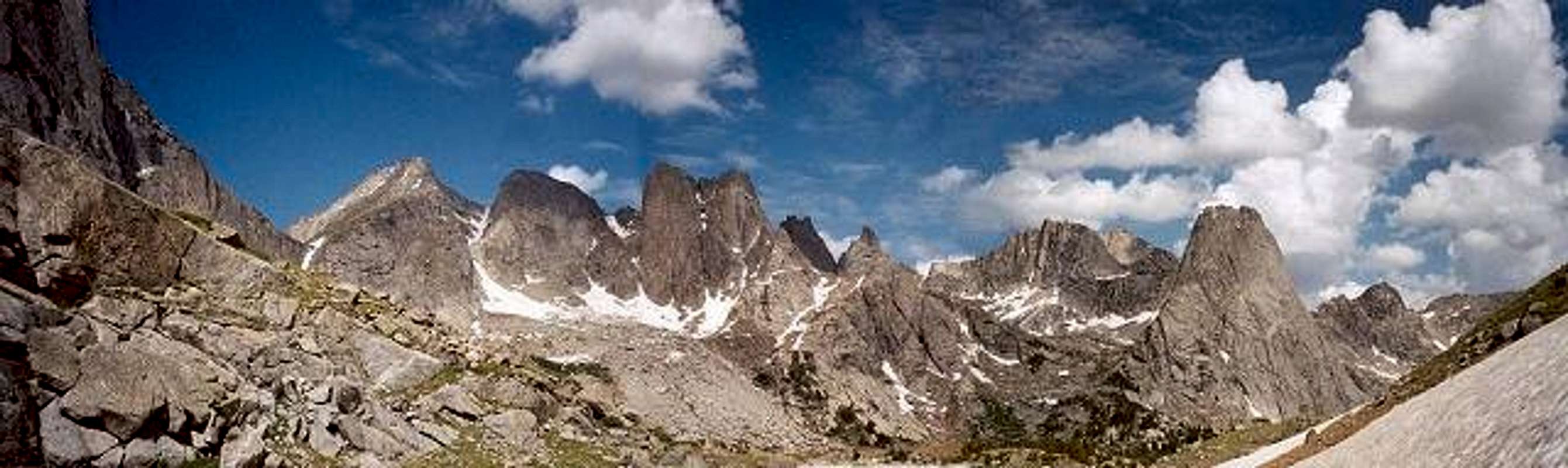
June 2002. Cirque of the Towers as seen from just below Jackass Pass.
Photo by jwclimbs
Cirque of the Towers. Even the name entices one to explore it’s realm. The Cirque lives up to it’s name with jagged granite spires and peaks hidden deep in the Rockies of Wyoming’s Wind River Range. As you arrive in the Cirque, climbers and hikers are awed by the sheer vertical walls and pointed towers which give the area its name. The towers surround the visitor on all sides with Lonesome Lake resting in the center.
The Cirque of the Towers was visited in the early 20th century. The first recorded visit and climb was in 1940 by Orrin Bonney and Frank & Notsie Garnick. Orrin Bonney climbed Pingora in 1940 and subsequently named the area “Cirque of the Towers.” Throughout the 1940's and 1950's all the remaining peaks in the area were climbed with Block Tower climbed last in 1957.
This is an alpine climber’s Disney Land. With routes from class 2 walk-ups to 5.11b technical routes, there is something for everyone. The two most popular peaks in the Cirque are Pingora Peak (11,884) and Wolf’s Head (12,163). Two routes on these peaks are considered classics and were made famous by the book, “Classic Climbs of North America,” by Steve Roper and Allen Steck. In addition, Warbonnet Peak is another fantastic climbing destination. The route, Northeast Face Left recently submitted by SP member, RPC, appears destined to be a Cirque classic.
With the spectacular scenery in the Cirque of the Towers, this area attracts many, many people, and thus, overuse is a problem. In fact, Lonesome Lake was the first lake in the Wind River Range whose water was deemed unfit for consumption due to human waste. However, if you avoid the lake water and concentrate on the climbing and the scenery, you will not be disappointed. The Cirque is a wonderful climbing Mecca and should be on everyone’s tic list..
Sources and contributors to this page:
“Climbing and Hiking the Wind River Mountains” by Joe Kelsey
Stuart Buchanan
jwclimbs
mccdermott22
Radek C. (rpc)
Getting There
The Cirque is located in western Wyoming’s Rocky Mountains in the southern Wind River Range. There is no easy way to get to the trailhead and many consider the drive to the main trailhead to be the first crux of a Cirque of the Towers expedition. The drive can be a daunting task for the directionally impaired. The best map available which shows all the dirt roads is the Recreational Map of Wyoming published by GTR and is available here or in Rock Springs and Pinedale.
The most popular way into the Cirque is through the Big Sandy opening/trailhead. Although the road is a fairly well-maintained dirt road, there is 30-40miles of it (depending on the route), with sections of washboards which will rattle your teeth. In addition to personal experience, these directions and mileage are taken from a combination of three guide books.
Jackass Pass and Climbers Pass. Photo by GCutforth
If coming from the north near Pinedale, Wyoming, drive 11 miles south on U.S. 191 to Boulder. From Boulder: Drive approximately 18.0 miles southeast on highway 353 on a paved road. Upon reaching a junction, shortly after the pavement ends, bear left (southeast) for 2.9 miles. At 2.9 miles bear right (still southeast). After approximately 6 miles, you will come to a signed intersection (A). Turn left (east), following the sign to Big Sandy. After 7.5 miles you will find another signed intersection (B) where you turn left (north) to Big Sandy. This winding road is steeper, and rockier but is still fairly good. Follow this road and signs for approximately 10.5 miles until reaching Big Sandy campground and trailhead (9080 ft).
If coming from the south near Rock Springs, Wyoming: Drive north on U.S. 191 to the town of Farson. Two miles east of Farson on highway 28, there is a sign to Big Sandy. Turn left (northeast) and drive approximately 40 miles of dirt road to intersection (A) as described above.
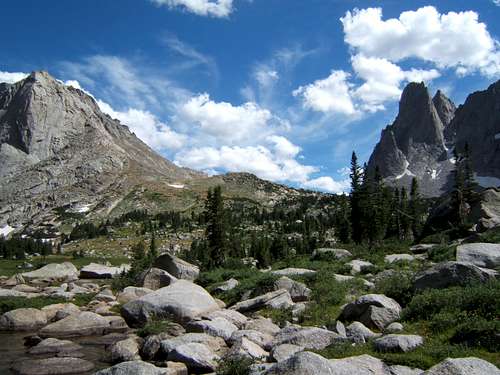
Follow the Big Sandy trail for 5.2 miles to Big Sandy Lake. Expect heavy traffic on this trail. There is only a 600 ft elevation gain on the trail to the lake. Upon arriving at the lake, follow the trail around the north side to the northeast corner. There, a sign will point to Jackass Pass. Turn north, following the sign to Jackass Pass. Switchback up a few hundred feet until reaching the entrance the pass. From here the trail sometimes fades while meandering up and down through slabs and boulders. Following this, the trail descends to North Lake and then circles around the north side of the lake. If you plan to climb Mitchell Peak you will begin your climb up the south slopes near North Lake. Following this, and after a short climb, the trail descends again to the south side of Arrowhead Lake (which will not been seen). After the descent, the trail will head up and to the right. Here a faint trail branches to the left appearing to go nowhere. At this point, you will not be able to see Arrowhead Lake. If you want to avoid another climb and take a short cut, it is important to find this faint trail to the left. Once on the faint trail, circle around the south, then west side of Arrowhead Lake. A short climb then a squeeze behind a large boulder will avoid a moraine. Once on the north side of Arrowhead Lake, the Cirque will come into full view and you descend through the pass to the southwestern side of Lonesome Lake. If you miss the faint trail south of Arrowhead Lake, that’s OK....you will still get there. Climb up and to the east side of Arrowhead Lake. After a rocky climb and descent you will come to a trail junction on the northeast side and above Arrowhead Lake. The right fork takes you to the southeast of Lonesome Lake, away from most of the climbing areas. The left fork traverses a hill on the north side of Arrowhead and eventually get you to the pass leading to the descent into the western part of the Cirque where Pingora, Wolf’s Head, and the majority of the climbing is.
An approach from the east from the Dickinson Park trailhead along the North Fork Trail offers another route to the Cirque. It is not as popular due to the 13 mile distance and four river crossings.
Noteworthy Peaks
Pingora: (11,884) Pingora is the most popular peak with the most popular climbing route in the Cirque. The South Buttress route (5.6, II) gets a lot of traffic. Expect several parties on this route daily during the season. After Labor Day, it is not as crowded. The Northeast Face (5.8, IV) is another popular route which is considered one of the fifty classic climbs of North America. There are approximately eight other routes from 5.4 to 5.9.
Wolf’s Head: (12,163) This striking feature connects to Pingora via a narrow east/west ridge. The classic route is the East Ridge (5.6, III). Although moderate, this route offers a unique ascent combining an exposed unprotectable ramp with several airy traverses. Joe Kelsey describes the route as requiring, “..a sense of whimsy.” Six other routes grace this peak from 5.4 to 5.10b.
Warbonnet Peak: (12,369) As you make your way towards Jackass Pass from Big Sandy, Warbonnet is the first of the towers seen as it guards the southern entrance to the Cirque. Warbonnet southeast face has the most difficult free route in the Cirque at 5.11a, grade IV. Other routes are from Class 3 to 5.10, with the standard route being the Northeast Face Left.
Pylon Peak: A relatively easier mountain to climb, Pylon offers a class 3 southwest gully and a class 2 west slope. The west slope begins on outside the Cirque near Donalds Lake. Check out the link for more info.
Mitchell Peak: (12,482) One of the few peaks in the area which has a non-technical route, Mitchell Peak rises prominently over Lonesome Lake's southeast side. It is the large mountain to the right as you are hiking north through Jackass Pass. The South Slopes route (Class 2) starts from the Jackass Pass trail near North Lake and follows the long scree slope to the summit. (Joe Kelsey). In addition, Mitchell Peak also has several technical routes including two routes on the imposing Northwest Face. Here is a very good report with photos by Rex Headd on a climb of Mitchell Peak.
Lizard Head: (12,842) The first peak climbed in the Cirque of the Towers, Lizard Head is on the northeast side of the Cirque away from the western peaks. Routes are from Class 4 to 5.9, VI, A3.
Overhanging Tower: (12,164) Another moderate peak considered the easiest of the Cirque Towers to climb with three routes: Class 4, 5.3 II, and 5.6 III. Overhanging Tower is southwest of Wolf’s Head.
Shark’s Nose: (12,229) On the south side of Overhanging Tower, Shark’s Nose can be reached by ascending the col above Cirque Lake and traverse south along the base of Overhanging Tower. Routes are 5.6, 5.7, and 5.8.
Warrior 1: (12,360) Warrior 1 is the elegant tower to the right (northwest) of Warbonnet. It hosts routes from 5.9, IV to 5.9, IV, A3. Warrior 2 is to the right of this peak with an additional four routes including a traverse to Warrior 1.
These are just a few of the peaks in the Cirque of the Towers. Others include: Camels Hump, Skunk Knob, Bollinger Peak, Block Tower, Elizabeth Peak, and the Watchtower. All these peaks and this area offer a lifetime of granite alpine fun. To fully enjoy the Cirque, Joe Kelsey’s guide, “Hiking and Climbing the Wind River Mountains,” is a must. The book includes topos, photos, and route descriptions of the major peaks in the Cirque.
Please note the Cirque Traverse route in the left side bar which is an excellent account of a grand tour of the Cirque of the Towers.
Red Tape
The Cirque of the Towers is located in the Bridger Wilderness of the Pinedale Ranger District of the Bridger-Teton National Forest. No fees or permits are required to climb, hike, or camp in the Cirque. There is a $8.00 per night fee if camping at Big Sandy Campground at the trail head. No camping is allowed within a quarter-mile of Lonesome Lake.
Bridger Teton National Forest
Pinedale Ranger District
29 East Fremont Lake Road
PO Box 220
Pinedale, WY 82941
(307) 367-4326
When To Climb
Climbing season is typically June through mid-September. June is considered the wettest month, while July and August are considered the months most common for afternoon storms. September can be a great time to climb with several days of dry, clear weather. However, September can also have early winter storms producing measurable snow. As with any alpine area, an early start is recommended to avoid afternoon thunderstorms. Check here for current weather conditons.
Camping
Camping is available at the Big Sandy trailhead campground for $8.00/night from June 20 to September 10. There is no fee before or after those dates. There are 12 sites with pit toilets, no water and no showers. Check here for other Forest Service campgrounds in the area. In the Cirque, most backpackers and fishermen camp closer to Lonesome Lake on the southern shores, but with the bad water in the lake and the distance to the climbs, this is pointless for climbers. Better water and campsites for climbers are found in the rocky meadows of the western part of the Cirque directly south or southeast of Pingora. The stream from Hidden Lake directly below Warrior Peaks is a better source of water. Treat or filter all water in the Cirque. There are a lot of campsites around Big Sandy Lake, but they are extremely overused, and are primarily used by backpackers and fishermen. Bears are a problem both at Big Sandy Lake and in the Cirque. Bear resistant canisters and tactics are recommended.
Mountain Conditions
The rock in the Cirque of the Towers is some of the best granite in the U.S and makes for wonderful placements and climbing. Rockfall is very common in the Cirque, with large releases resounding through the area on a daily basis. Ice and snow are common on north facing slopes and couloirs and sometimes never melt during the summer season. Check here for current weather conditons. Here is a live webcam shot of the Wind River Range.

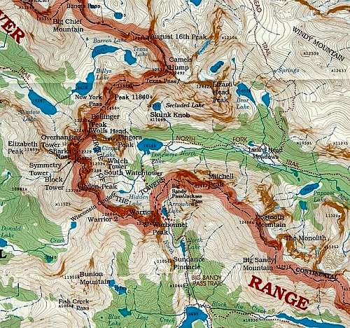
Maps
Earthwalk Press: Southern Wind River Range
USGS Quads: Big Sandy Opening (approach), Temple Peak (approach), Lizard Head Peak (Cirque), Mt. Bonneville (eastern approach)
Forest Service: Bridger-Teton National Forest Map
Online: Pingora Page (Summit Post) by jwclimbs
Online list of all maps and ordering information.
Online Clickable Map of Bridger Teton National Forest
Cirque Traverse Speed Record
On August 13, 2002, SP member Ryan McDermott and Jared Campbell set a car-to-car speed record of the Cirque Traverse in 14.5 hours, doing it mostly solo. It shattered the 2001 record set by Dave Anderson by two hours.
Source: Climbing Magazine, Issue 223, August 2003.
In 2006, Dave Anderson broke Campbell and McDermott's 2002 record, doing the traverse in a blistering 13.25 hours car to car.....solo. Source: www.FirstAscentPress.com
In Memoriam
On September 22, 2001, Michael “Scott” Shaw, (31) from Talkeetna, Alaska died while descending from Wolf’s Head Peak in the Cirque of the Towers. He was a very experienced climber and a National Outdoor Leadership School Instructor. As he was pulling ropes following a double rope rappel, one of the ropes become stuck. While on belay and placing protection, Shaw re-climbed the route to retrieve the rope. Near the top, Shaw pulled off a 250 lb. rock, yelled "Rock," and began to fall. The rock hit the rope attached to Shaw, cutting it completely . He fell approximately 300 ft with two feet of rope still attached to his harness. Efforts to save him were futile.
Source: “Accidents In North American Mountaineering 2002” The American Alpine Club.
I wasn’t sure about adding this section. Although other accidents have happened in the Cirque, this one struck me as especially tragic. Even though I didn’t know Scott, I feel a kinship with him having also climbed in the area, and wonder how something like this could have happened in such a beautiful place.
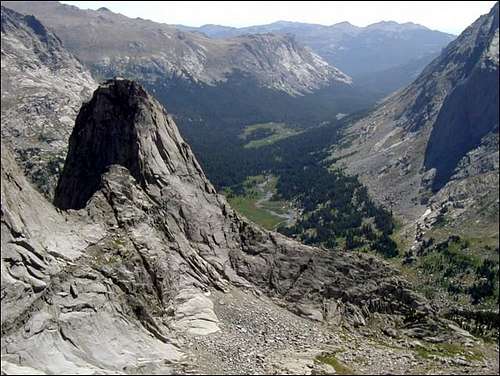
Photo by Ryan McDermott
External Links
- TR: Cirque of the Towers, WY - June 2002
- Wet and Wild in Wyoming's Winds
A trip report with photos and such of three guys and the ultimate bachelor party.
PellucidWombat - Feb 16, 2011 2:52 am - Hasn't voted
Big Sandy Opening TH DirectionsFor those more visually inclined: Google Map from Boulder, WY
Alan Ellis - Feb 16, 2011 9:48 pm - Hasn't voted
Re: Big Sandy Opening TH DirectionsThanks for posting!