

|
|
Area/Range |
|---|---|
|
|
39.06500°N / 108.748°W |
|
|
7132 ft / 2174 m |
|
|
Overview
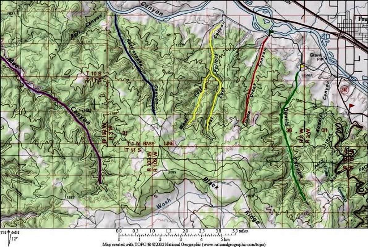 Map of some of the canyons in BRCW: Mee Canyon marked in purple, Rattlesnake Canyon marked in blue, Pollock Canyon marked in yellow, Flume Creek Canyon marked in red, and Devils Canyon marked in green. |
The Black Ridge Canyons Wilderness Area (BRCW) page is offered in the spirit of the Island in the Sky, Canyonlands Nat Park page, Wheeler Geologic Area page and the Grand Canyon page. While BRCW contains no mountains, it does contain miles and miles of great hiking and some spectacular scenery. For the more adventurous, several of the canyons offer technical canyoneering opportunities.
The United States Congress designated BRCW in 2000 and it now has a total of 75,550 acres. BRCW is located approximately 15 miles west of Grand Junction, Colorado on the northwest flank of the Uncompahgre Plateau. It is bordered by the Colorado National Monument to the east and the Colorado/Utah boundary to the west, with a small portion (5,180 acres) actually spilling into Utah. The elevation ranges from 4,300 feet at the river to a high point of 7,130 feet. The Wilderness is included within the Colorado Canyons National Conservation Area (CCNCA), which was legislatively designated in October of 2000.
BRCW is characterized by the high, east-west trending Black Ridge dissected by seven major red rock canyon systems, draining into the Colorado River. Canyons vary in length from several miles to twelve miles in length and may contain interesting side canyons. Geological features in these canyons include spires, windows, giant alcoves and desert patina. Canyons may reach a depth of almost 1,000 feet, forming spectacular redrock cliffs. Spring runoff and summer thunderstorms create glistening waterfalls and plunge pools. The area contains the second largest concentration of natural arches in the United States. Vegetation in the meandering canyon bottoms include pinyon-juniper, grasses, and cottonwoods, willow and box elder. The upland mesas contain a dense stands of pinyon-juniper with some sagebrush parks. Cryptobiotic soils are well developed in the upland area. Wildlife viewing may include deer, mountain lion, desert bighorn sheep, along with golden and bald eagles. The normal wilderness activities of hiking (on trails or cross-country), horse riding, hunting, backpacking and primitive camping are all available. The Colorado River offers rafting, canoeing and kayaking opportunities.
Because of its recent wilderness designation, and the proximity of its better-known neighbors (Colorado National Monument, Moab, and Arches National Park) BRCW remains a relatively undiscovered hiking Mecca. Also, due to the climate of the area (hot and dry), BRCW lends itself to winter outings. When your favorite Colorado peaks are covered in feet of snow and the temperatures in the high country dip towards zero, consider hiking BRCW where you’ll encounter no snow and mild temperatures.
Thanks to www.wilderness.net and www.co.blm.gov/gjra for much of the information posted to this page.
 |
 |
 |
 |
 |
Getting There
There are basically 4 nodes from which to access the interior of BRCW:
- Devils, Flume, Pollock Bench, and Rattlesnake Canyon Trails: From Grand Junction, take I-70 west to the Fruita exit, turn left and cross back over I-70 and go 1.5 miles to the Kings View Estates subdivision. Turn right, in to the subdivision and stay on the main road. It's approximately .5 miles to the Devils Canyon trail turnoff, on your left - look for the yellow gate. Continuing down the main road a little farther, approximately 1.5 miles, will bring you to the Pollock Bench, Flume and Rattlesnake Canyon trailhead.
- Knowles and Jones Canyon Trails: From Grand Junction, travel west on Grand Avenue, cross over two bridges, at the next stop light turn left on to Monument Road, turn left at "D" Road. Follow D road until you come to a fork in the road, go left on to Little Park Road. Follow Little Park Road until it meets up with DS Road, take a left on to DS Road to the Glade Park Store. At the Glade Park Store take a right on to 16.5 Road go .5 miles to BS Road, turn left, it's another 12 miles to the Knowles Canyon trailhead. Continuing on BS Road another 2.5 miles you will come to a locked gate at the end of the public road, this is the trailhead into Jones Canyon.
- Rattlesnake Arches and Mee Canyon Trails: There are two roads that parallel the southern boundary that are seasonally opened to motorized travel. These roads provide access to Rattlesnake Canyon/Arches and Mee Canyon trailheads. The Upper Road is open from April 15 - August 15, with the Lower Road being open from August 15 - February 15. Both roads are closed to motorized travel from February 15 - April 15. (CAUTION: A high clearance 4X4 vehicle is required for the last 1.5 miles. Do not drive on either road when wet. I tried to drive this road 9/20/03 in my Saturn VUE. I would not recommend trying to drive any part of this road without a high clearance vehicle.) To get there from Grand Junction, take I-70 west to the Fruita Exit (#15) turn left at off ramp and cross back over I-70, follow signs to Colorado National Monument (CNM). Enter the CNM. Travel 11 miles from CNM entrance station; turn right at sign for "Glade Park Store.” Travel .2 miles to Black Ridge Access Roads (Upper and Lower). At this point you are adjacent to the Black Ridge Canyons Wilderness. The Rattlesnake Arches trailhead is approximately 13 miles ahead. (NOTE: There is no charge for traveling through the Colorado National Monument to access the Black Ridge Canyons Wilderness. Inform the attendant at the entrance gate that your destination is the Black Ridge Canyons Wilderness and you will be permitted to pass through the monument at no cost.)
- Colorado River Access: The most spectacular access into the canyon mouths is by floating the Colorado River from the Loma boat launch. Rattlesnake Canyon has a hidden mouth 3.3 miles below the Loma put-in. Mee and Knowles Canyons are the two longest canyon systems and their river entrances are popular campsites for the river trips and hiking. Private land blocks river access to Jones Canyon in Utah. The Loma boat launch is reached via I-70 west of Grand Junction to the Loma exit. Go south on the overpass and follow the signs to the launch.
 |
 |
 |
 |
 |
Red Tape
A Resource Management Plan (RMP) is currently being developed for the Colorado Canyons NCA, and is slated for completion in June of 2004. The primary focus of the Plan will be to protect the natural resources and provide recreation opportunities for the public, consistent with NCA values.
Regulations presently in effect include group size limits of 25 people traveling in the canyons south of the river and 12 people accessing the Rattlesnake Arches area. The Rattlesnake Arches vicinity is day-use only. At the present time, there are no fees for the wilderness or the rest of the Colorado Canyons NCA.
Unless otherwise specified, no motorized or mechanized use is allowed. This is true for all federal lands managed as designated wilderness. The higher elevation access points may not be accessible during wet weather, as the roads become muddy and slick and include several steep sections. During wet weather, the dirt roads that access the higher elevation trails may not be drivable and may be gated.
Fire pans (or the equivalent) and portable toilets are required for the river corridor.
 |
 |
 |
 |
 |
When To Hike
This area can be hiked all year. Beware that temperatures in the summer are usually in the 90's and often rise above 100o. Under these conditions, at least one gallon of water per person per day is the rule of thumb. The BLM warns that biting gnats are prevalent from late May through late July (though I've hiked the area in mid June and didn't experience any problems).
Be aware that access to the higher elevations may be limited during periods of excessively wet weather. Some roads may become muddy and slick and include several steep sections. During wet weather, the dirt roads that access the higher elevation trails may not be drivable and may be gated.
Contact the BLM Grand Junction office before attempting to access the higher elevations during the winter and early spring.
 |
 |
 |
 |
Camping
For campgrounds, it is recommended that you contact the BLM Grand Junction Field Office to make sure they are open and accessible before attempting to use them during the off season.
- Within BRCW Camping in the wilderness is allowed everywhere except for a few notable exceptions. These include the immediate vicinity of Rattlesnake Arches, Pollock Bench, Lower Flume, and Lower Devils Canyon. Note that there are very few reliable sources of water so plan to pack in all your water. However, there are some permanent springs and pools scattered through Mee Canyon. See the Red Tape section for a few other regulations.
- Rabbit Valley Campgrounds Rabbit Valley contains three designated campgrounds: Rabbit Valley, Castle Rock, and Knowles Canyon Overlook. There is no fee to use these campsites and they’re first come - first serve. The facilities include tables, grills, and toilets, but NO WATER. To get there from Grand Junction take I-70 west to the Rabbit Valley exit. At the off ramp take a left, crossing over I-70 going south, Rabbit Valley is straight head. The BLM warns against taking travel trailers or RVs to the Castle Rock or Knowles Canyon Overlook camp sites due to the rough roads.
- Big Dominguez Campground There is no fee to use these campsites and they’re first come - first serve. The facilities include tables, grills, and toilets, but no water (though you can get water from Big Dominguez Creek and filter and/or boil it). To get there from Grand Junction head south on Hwy 50 to Whitewater. At Whitewater make a right turn on to Hwy 141. Travel 11.5 miles to the Divide Road turn off (Uncompaghre National Forest Access Road) on your left. The road winds and switchbacks to the top of the mountain. At the top stay on the main road until you come to a fork in the road. At the fork, follow the signs to Dominguez Conservation Area (left). In approximately 5 miles the Big Dominguez Campground will be on your right. The BLM warns that the road can be hazardous and recommends not taking taking RVs or travel trailers to the campground.
- Miracle Rock Campground There is no fee to use these campsites and they’re first come - first serve. The facilities include tables, grills, and toilets, but NO WATER. To get there from Grand Junction follow signs to the Colorado National Monument. Once in the monument take the Glade Park Store turn off, travel 8 miles west past the Glade Park Store (DS Road) to 9.8 road and turn left. The recreation site is 1 mile on left hand side of road.
- Mud Springs Campground There is a $5 fee per campsite per night and they’re first come – first serve. The facilities include tables, grills, and toilets, and drinking water. To get there from Grand Junction go west on Grand Avenue, cross over two bridges, at the next stop light turn left on to Monument Road, following the signs to the Colorado National Monument. Turn left on to "D" Rd. Stay on D Rd until you come to the "No Outlet" sign, go right, you are now on Little Park Rd. Travel 10 miles on Little Park Rd until it meets up with DS Rd. Go left on to DS road and travel a little over a mile to 16.5 Rd at the Glade Park Store intersection, turn left onto 16 1/2 Rd, travel south, 6 1/2 miles, Mud Springs Recreation site, is on your right.
Contact BLM Grand Junction Field Office
The people at the BLM Grand Junction Field Office are super friendly and happy to give you whatever information you want. They’ll also send you free maps and brochures. Here is the contact info that I pulled off of their website:
- Address: 2815 H Road, Grand Junction, CO 81506
- Voice: (970) 244-3000
- Fax: (970) 244-3083
- Office Hours: M - F, 7:30am - 4:30pm MST
- Website: http://www.co.blm.gov/gjra/gjra.html
External Links
- BLM Grand Junction Field Office
The BLM administrates BRCW and this is place to go for all the official info as well as obtaining free maps and brochures.
Scott - Mar 30, 2006 10:33 pm - Hasn't voted
Area/RangeHi Andy. I think this could be changed to an area/range page instead of an individual mountain&rock page? What do you think?
Andy - Mar 31, 2006 2:55 am - Hasn't voted
Re: Area/RangeSure - do you think it needs any other changes?
Scott - Apr 3, 2006 1:02 am - Hasn't voted
Re: Area/RangeSure - do you think it needs any other changes? Looks good and complete. Perhaps mention that there are many towers for rock climbing, as well as some popular rock climbing routes on some of the towers in Devils Canyon. Knowles has some rock towers in the lower end that are supposed to be good climbs. I attached the Cowboy Hat Tower since its a part of the Black Ridge, but its just a small tower.