

-
 137547 Hits
-
 98.61% Score
-
 86 Votes
|
|
Mountain/Rock |
|---|---|
|
|
67.90454°N / 18.52710°E |
|
|
Hiking, Mountaineering, Trad Climbing, Ice Climbing, Aid Climbing, Skiing |
|
|
Spring, Summer, Fall, Winter |
|
|
6880 ft / 2097 m |
|
|
Overview
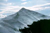
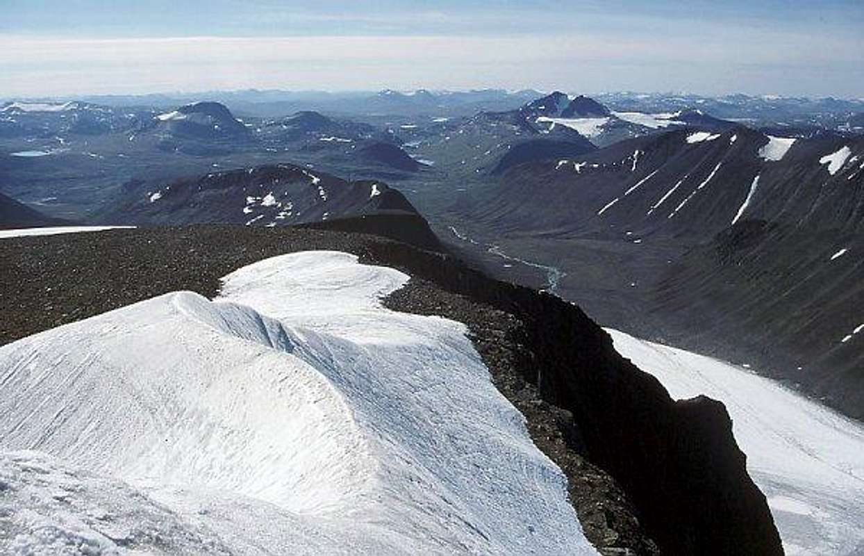
Kebnekaise, at 2097 metres in the very north of Sweden is the highest mountain in the country. In Skandinavia only Norway has higher peaks. It's situated far north, above the Arctic Circle. The Arctic circle is an imaginary line, about approximately 2600 km south of the North Pole. There is one equivalent the same distance from the South Pole. Above this line the sun never sets during the summer solstice, and during winter solstice it will never rise. This phenomenon have many popular names as the Midnight sun, the Polar Day, the Eternal night, the Polar night. Up here the day last from approx. 25 of May to 18 of July. The Arctic circles change their positions due to the relationship between earth's axis and the sun. At the moment it moves 14,4 meters/year. There are two distinct summits on Kebnekaise, Sydtoppen/South Summit (2097 m) and Nordtoppen/North Summit (2097m). Sydtoppen was the highest point of Sweden and the old elevation was usually given at 2113m. Due to recent warm periods the summit ice has melted and in the summer of 2018 scientists measuring the summit gave the Northern Summit the crown. On the summit there's snow and ice all year around. The height varies, depending on time of year and weather. Sydtoppen is a small glacier, about 40 meters thick. Bring crampons to prevent you sliding off to certain death, it's a open fall on one side, several 100 meters. There has been fatal accidents.
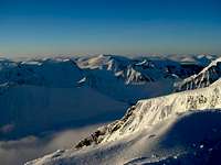
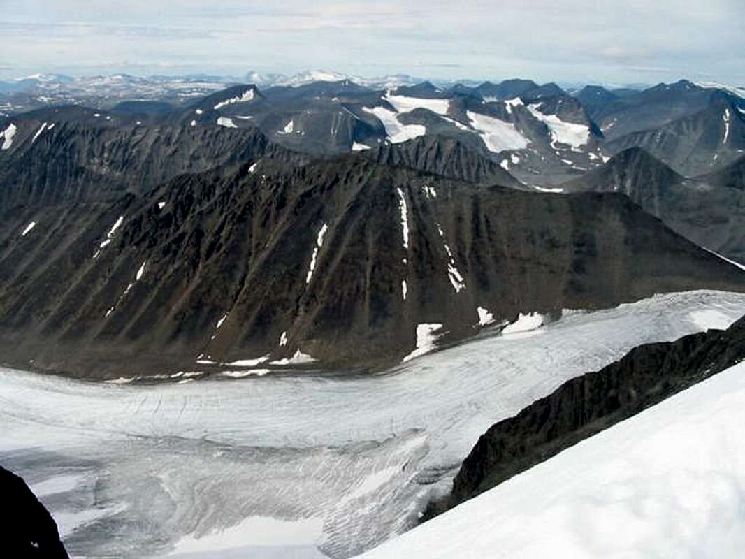
The summit is a tiny little place, not much place to do anything but enjoy the views. One can cross over to the north summit, by an airy ridge The area is really a group of mountains, with three other peaks higher than 2000 m and numerous lesser. The area is heavily glaciated, about 40 glaciers. This is a very popular area to trek in summertime or ski in winter. The most popular walk is a marked path, Kungsleden, 450 km long, passing by Kebnekaise. It goes from Hemavan to Abisko. You can drink the water straight out of the brooks almost anywhere, except at crosspoints where many people meet. The wildlife consist of some rarely seen mammals, bear, wolverine, lynx and wolf, birds like eagles and mosquitos. The mosquitos are mostly found in the lowlands, the valleys like Vistasvagge. They come in all sizes, and the smaller, the worse. A mosquito repellent is absolutely necessary part of the gear. One can also see raindeers, but that's not wildlife, it's cattle. They belong to the Samis. There are several routes to the top. It has two easy routes, both requiring only average fitness, Durlings led and Västra leden (Western route). Durlings is the longest but easiest. Västra leden is easily a solo walk, scrambling on some parts. Rocky routes with snow patches. Västra leden goes by Vierramvare, Kaffedalen (where one can put up a tent, if one doesn't want to go both up and down in one day) and finally to Sydtoppen.
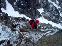
Östra rutten (east route) goes over a glacier, which best is done with a guide. The east route is airy on the final ascent. The ascent takes about five hours, with the east route being shorter. It is possible to shave of some time of the west route by choosing to camp higher up and further from the Kebnekaise fjällstation. Requires experience of easy alpine climbing and glaciers. If one lacks this it is advised to make use of mountain guides at a cost of SEK 450 ca. (2003) Drakryggen, The Dragon's back, is the ridge seen on the photo below. There are several peaks close by, like Kaskasapakte and Kaskasatjåkka north of Keb. Vieranvarri, Tuolpagorni is very close, south of Keb. Singitjåkka is south of Keb, beside Tuolpagorni. There are also Nygrens led, which can be done more or less technical after preferences. The approach to this route is from Tarfala. If one prefers a little more technical routes, choose routes from Tarfala. It's a bit rocky place to camp by the lake (1100 m), but it can be done. If one wants to do some ice climbing (winter), there's the Ice fall. It's about a 100 meters high. An article about the new elevation and the fact that Nordtoppen now is the highest point of Sweden. Europe's extreme summer is so hot it melted the highest peak in Sweden, and now it's only the second-highest
Getting There
To get to Kebnekaise the most direct route take the train or airplane to Kiruna in northern Sweden. The train (SJ) takes 26 hours from Malmö in southern Sweden, if you want to continue by train from Europe. From Stockholm it takes 20 hours. There are sleeping wagons with different standards on beds. The flight (SAS) takes between 1,5 or 2,25 hours från Stockholm, depending on chosen flight. Nordic Airlink (link to English on page) flies to Kiruna as well, departing from Arlanda. Fares are SEK 349-899 one way, depending on seat availability, flights are in the early evening. It's also possible to fly on standby to Kiruna, and pay 400 SEK from Arlanda and 700 SEK from Malmo with SAS, when you're under 26. From Kiruna take the bus (cheap) or taxi (expensive) to Nikkaloukta (it takes an hour or two), if you choose the shortest route to Keb. Walk from Nikkaluokta about 19 km to Kebnekaise fjällstation, which is a hostel, hotel, etc. There is an option to pay for a boat ride that will eat about 6 km of the walk. You may set up your tent anywhere, see Red Tape section. However, if you set up the tent next to the fjällstation you will be required to pay a fee. Some service is then included. For those in a hurry there are helicopter options, about SEK 600 one way (2003). In the winter you can get transported on a snowmobile (snöskoter), for about SEK 150 (1998). An alternative way take the train to Abisko from Kiruna, walk Kungsleden through the National Park, pass Alesjaure and from there on to Kebnekaise. It's a very nice trek. (You can also pick Njulla before leaving Abisko). This route will take you about 5 -10 days, depending on choice of route and other preferences. The easy walk will be along Kungsleden. If you're heading for Tarfala, choose Vistasvagge. One can also take the train from Narvik in Norway and get off at Abisko. Same route as above down to Kebnekaise. Some updates on prices on Kebnekaise Fjällstation (mid 2010): Accommodation for a night per person ranged between 350-450 SEK per night, depending on where you slept. No information about cabin prices. Helicopter update as of August/2012: Schedule: Departing from Nikkaluokta 09.00 Departing from Kebnekaise 09.15 Departing from Nikkaluokta 17.00 (between 25/6 - 2/9) Departing from Kebnekaise 17.15 (between 25/6 - 2/9) Price, one way per person: Adults 800:- SEK (~100 EUR, ~120 USD) Children, 2-11 years old 500:- SEK (~60 EUR, ~74 USD) Children, under 2 years old Free of charge Included 20 kg luggage per person. Extra luggage 25 SEK (~3 EUR, ~4 USD) / kg.
Red Tape
There is none and you're allowed to walk almost everywhere, it's a free country. Follow the rules of the Allemansrätten. To bring your dog is fine, but you must either have it in leash or have such a control as it were on a leash. Summertime rule (law). There are several National Parks in the area or close by, but as long as the dog stays on Kungsleden, and only there, it's allowed into the parks.
When To Climb
Summer season is from June to September, July and August being most popular. In winter it's perfect for ski mountaineering, but beware of avalanches and snow storms. The peak of winter season is in Spring months, when the cold has mellowed a little bit. June has more water running and possibly some snow. In September temperatures during the night will drop below zero degrees Celsius.

Camping
Due to Swedish right of common access Allemansrätten anyone is entitled to camp in the wild for free, both on public and private land. The essence of the right of public access is concisely expressed by the phrase, "Do not disturb, do not destroy". On private land one is allowed to stay one or two nights at one spot, without permission of landowner. Camping in large groups with several tents requires the landowner's permission. If there is houses nearby, put your tent up out of eyesight, since it's not allowed to disturb local residents. The link above provides excellent information on these rights, what's allowed and what's not. Up here it's public land and very few habitations. National parks like Abisko and nature reserves has other and stricter rules, they have signs at the borders of the areas. This right of access does not apply to motor vehicles and it's forbidden with terrain-driving. Private roads are marked and anyone who fails to observe such a prohibition is subject to fine. Kebnekaise fjällstation arranges tours of varying length and difficulty. Svenska turistföreningen are responsible for most of the cabins. Plenty of information, available in English or German. If the cabin isn't occupied, one can use it. If beds are full, sleep on the floor. Garbage is left at the huts of STF for free. The huts cost money. In some bigger places there's a "stugvärd" (cabinhost) who's responsible for the place. At 690 meters over the sea Kebnekaise Mountain Lodge is located which is a great place to stock up on food and other goodies. They have everything you might need there in terms of food and also a great restaurant.
Mountain Conditions
The weather can change very fast. SMHI (weather forecasts) Water is plentiful. However it is not advisable to drink water coming from Kebnekaise because of the number of people walking to the top. So bring your own drinking water when ascending.
Miscellaneous Info
National Geographic's The 11 Top Trails of the world But he's wrong though, when he says: "While it is possible to hike in either direction, it's best to travel from north to south—that keeps the sun warming your face, no small consideration in the Arctic." It doesn't matter - the sun shines from the north too, in the summer and in winter there's no sun at all.
In Kiruna you can visit iron ore mines. Be sure not to miss information on the Sami people, which are native to the lands in northern Scandinavia. They live traditionally on reindeer herding. Smoked raindeer meat is a treat. Mind you, it's utterly impolite to ask a Same how many raindeers he has. Their handicraft, especially knives and skins are sold throughout Norway, Sweden and Finland. The silverembroidery is very distinct and special. Almost everybody speaks English, you won't have any problems communicating with people. Most people also another language, most common is German. Small dictionary: grader = degrees, in Celcius. dal=valley jokk=creek (only in Lappland) träsk=lake (only in Lappland)
External Links
- kebnekaise
kebnekaise information in swedish - Kebnekaise Mountain Lodge's website
- Marco Klüber Fotografie
Photos of Lappland including Kebnekaise Area - A trip report written by my climbing mate Jacob
- The highest peak in all European countries.
guhj - Oct 27, 2011 11:20 am - Voted 6/10
Room for improvementThe article is definitely useful in its current state, but there's some room for improvement. 1) The stated summit height is not the same throughout, and it's not any of the commonly accepted numbers I've seen (I'd propose using either the latest measurement or whatever's on the map). 2) Since "real" climbing (trad, aid, ice) is mentioned at the top of the page, it would be prudent to include route descriptions, or at least hints as to where those possibilties are. Maybe reference Klätterförbundets Kebneförare? 3) Overall, the structure of the article and the spelling/grammar/wording could use some work. Too many small nitpicky issues to point them all out here, but I'm willing to fix them if I can get editing permission (or just shoot me a PM and we can start fixing stuff that way).
Jukka Ahonen - Aug 15, 2012 6:41 am - Voted 8/10
Helicopter updatesHelicopter update as of August/2012: Schedule: Departing from Nikkaluokta 09.00 Departing from Kebnekaise 09.15 Departing from Nikkaluokta 17.00 (between 25/6 - 2/9) Departing from Kebnekaise 17.15 (between 25/6 - 2/9) Price, one way per person: Adults 800:- SEK (~100 EUR, ~120 USD) Children, 2-11 years old 500:- SEK (~60 EUR, ~74 USD) Clihdren, under 2 years old Free of charge Included 20 kg luggage per person. Extra luggage 25 SEK (~3 EUR, ~4 USD) / kg.
Corax - Sep 7, 2012 7:05 am - Voted 10/10
Re: Helicopter updatesThanks! Included on the main page now.
rgg - Aug 11, 2018 3:46 am - Hasn't voted
South summit isn't the highest anymore.It finally happened: the small glacier on top of the south summit has melted so much during this hot summer that the north summit is now higher, and consequently the north summit is the new high point of Sweden. Lots of news articles covered this. One example: https://www.svt.se/nyheter/lokalt/norrbotten/farsk-matning-kebnekaises-nordtopp-hogst
Corax - Aug 23, 2018 8:28 am - Voted 10/10
Re: South summit isn't the highest anymore.Thanks for the info. I will add a link to some English language information.