

-
 53335 Hits
-
 90.48% Score
-
 32 Votes
|
|
Mountain/Rock |
|---|---|
|
|
48.78580°N / 116.7195°W |
|
|
Mountaineering, Trad Climbing, Scrambling |
|
|
7288 ft / 2221 m |
|
|
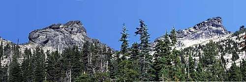
West(L)and East(R) Lions Head from the south
Overview

From the north.
The Lions Head is comprised of 2 massive granite summits, known as West and East Peaks. The elevation of the lower but more difficult West Peak is 7226 feet, while the East Peak is 7266 feet high. It lies one drainage west of Pyramid Peak and is composed of the same fine granite as Chimney Rock, which lies about 15 miles south of The Lions Head. There are great opportunities for technical routes at all difficulties, and it is remote. According to Tom Lopez, Neil McAvoy first climbed East Peak in 1964. However, Laird states in his guidebook that the West Peak was climbed in 1938 - the summit register (tin box, not the white PVC pipe - notes in the register state that the pipe allows too much moisture, so replace the register into the tin box!) contains a note by Lloyd Walter of Bonners Ferry dated July 28, 1938. This note was still there and legible as of July 17, 2009.
Getting There
To reach the area, drive to Priest River, Idaho, which lies on US highway 2, 30 miles west of Sandpoint, ID, 10 miles east of Newport, WA, and about 50 miles north of Rathdrum. In Priest River, turn north onto Idaho highway 57. After about 30 miles, turn east to Coolin, Idaho. Continue on the road that follows the east shore of Priest Lake towards the Lionhead Unit of Priest Lake State Park.
Now you have 2 choices: the Abandon Creek approach or the Lion Creek approach.
Abandon Creek Approach:
WARNING The last 6 miles of road to the trail head is rough. A vehicle with good clearance is recommended and depending on conditions, 4WD would help. We made it with my Subaru Impreza Outback. The road has been improved to the junction with the IDFR #43. After that, some of the water dips have been fixed and the road is basically fine. HOWEVER, on the last switchback they fixed the washout from 2008 by putting in 2 very high water bars and graveling them. I was able to drive around them - otherwise, we would have been walking from there.

Abandon Creek Trailhead
Continue past Lionshead Campground for about 4 miles. Turn right onto Idaho State Forest Road #44. After 2.4 miles, you will pass the intersection with ISFR #43 (the way to Lookout Mountain). Continue on 44 for another 3.5 miles. You will cross Abandon Creek and come to a T-junction. Turn right and drive for another 0.3 miles to a big switchback and park. If you come to a gate, you went too far. Follow the ATV trail to a trail that takes you up east of Abandon Creek and to the north side of The Lions Head. The trail ends after a little over 1 mile and 1000 feet of elevation gain in a large boulder field beneath the towering north face of West Lions Head. From here, it is a lot of boulder hopping to get to your destination.

Topographic Map showing Trail

Google Earth Image showing Trail
To get around to the south side of West Lions Head or to gain the notch between the peaks, head towards the big shoulder that extends west from West Lions Head. Work your way up almost to its base and then trend west along a ramp until you can easily reach the crest of the shoulder - do not attempt this too early! Make sure to mark this point for the return trip. Some cairns are already in place. Now walk east along the crest of the shoulder towards the base of the west face. Cross the boulder field southish towards a low point in the south ridge of the West Lions Head. Drop down a short ways and then head along the south ridge for the start of the south face routes on the West Lions Head or continue on to the grassy ramp that leads to the notch between the peaks.
Lions Creek approach:
This one will work, if your car cannot make it up the Abandon Creek road. It is 45 minutes driving time less, the same hiking mileage in, but all bushwhack and 1000 feet elevation more gain. My guess, the time works out about the same. The bushwhacking is not all that bad. It takes about 2 1/2 hours to get to the basin south of the peaks. This basin has far fewer boulders crossing it and to the achieve the notch between the peaks or the south ridge of West Lions Head is only another hour. That's how long it took us to get to the same place from Abandon Creek.
Before reaching the Lionshead unit, about 23 miles north of Coolin, turn east onto Lion Creek Road (State Forest Road #42) just after crossing the Lion Creek Bridge. There are several low angle forks - always take the left one, but ignore any sharp lefts. The trailhead is marked with some large boulders and is about 4 miles from the main road. There is a sharp switchback left and numerous very large granite slabs on both sides of the valley here. This is also the trailhead for the Slippery Rocks, a popular area where Lion and Kent Creeks go over granite slabs to form a natural water slide.
The road is generally is good shape and passable by passenger car, but has numerous water dips and potholes. There is ample parking at the TH.
Hike along the old road east. The real trick is finding the correct drainage up which to bushwhack. You will cross 3 streams (there are more crossings, where the culverts were removed, but it's easy to tell the difference). Along the way you will pass by the remains of a building. The correct drainage can be identified by the old clearcut or burn up on a knoll just NW of the creek.
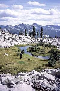
The pond in the cirque
About 20 yards east of the draw there is a trail going down to Lion Creek. It's about 25 minutes walk from the car. If using GPS, on NAD27, the coordinates of the creek crossing are 48.7644°N, 116.7159°W or UTM Zone 11, 520879E 5401080N.
We went up the drainage, staying west of the creek. There are several cliff bands to navigate around, but stay within earshot of the creek. You will come into a cliff/talus area at the base of a ridge buttress. Mark your way through this area - it may be hard to find your way back down. Work your way east to the creek and cross it. You are now in the cirque at the head of which is The Lions Head. We found the bushwhacking tedious, but not really too bad. It's about 1.25 miles and 2500 vertical feet to reach the cirque and it took us 2.5 to 3 hours. Once in the cirque, walk the granite slabs and talus towards the notch between West and East Lions Head. You will pass a small pond that is the head of the creek along the way. It's the only feasible camping spot in this cirque. About 45 minutes to the pond, another half hour to the notch. Total distance from the car to summit is a little over 3 miles and 3200 feet vertical rise.
It looks like following the east side of this drainage would be feasible, but with many more rock outcrops. The tendency of these outcrops is to drop off very steeply, so although this side appears more open, it may actually be harder to navigate.
Routes

Route to the saddle from the south. Follow the grassy ramp.
Guidebook: Climber's Guide to North Idaho and the Cabinet Wilderness by Thaddeus Laird.
The peak is also described inadequately and incorrectly in Lopez’s Idaho, A Climbing Guide. In his defense, it can be noted that this is a general guide to nearly every peak in the state.
If you want to do any technical routes here, you will want Laird’s book.
East Lions Head
Only one route is described on the East Peak.
West Ridge/NW Flank (Regular) Route- Class 3 (Laird says Class 4)
Tom Lopez's guidebook Idaho, A Climbing Guide is completely wrong in describing this route. We ended up wasting nearly 1.5 hours trying to follow his description, which sends you to the wrong side of the peak!

East Peak from the west peak. Click for detailed caption re the route

On the low angle slabs
Here is a more accurate description:
After reaching the head of the cirque south of The Lions Head, find your way through some steep gullies to a grassy ledge that crosses under the SE face of the West Lions Head to the notch between the peaks (.i.e., west of the East peak NOT NORTH). Once in the notch, walk along the crest towards the west ridge of East Lions Head. To the N, NE you will see a huge, very low angle granite slab area. You cross this to the ridge with talus and trees on the other side.
Although this crossing is very easy, it is exposed and care should be taken, especially if the rock is wet or icy. Now follow the ridge to the summit (about 10 minutes). There is a summit cairn. A plastic bottle as register is hidden inside it, but needs paper and pencil.
The descent follows the same route.
West Lions Head

The impressive north face. The Lion Tamer is on this face.

East Buttress
All the named, established technical routes are on the West Peak. Some ascents are mentioned in the summit log, but no details of the exact location of the routes are known.
The routes in Laird are:
East Buttress (5.7) 3 pitches – details are included
The Great White Corner (5.9) 1 pitch (a variation of the East Buttress) – details are included
Northeast Face (5.7 A2) - no details known
The Lion Tamer (5.10) 6 to 7 pitches – details included
Catacombs (5.7) 3 pitches – ascends a chimney system on the west face – no details given
Southern Slabs (5.4 R) 3 pitches – details included. The easiest route on the peak
South Face – no details known
Southeast Face / East Buttress Linkup (5.8) 6 pitches – details included
Descent: Two rappels – 60 meter rope recommended. The first rappel is from trees at the top of the Southern Slabs Route. If you came up another way, follow a faint track down the gentle slopes to the west of the summit. You will eventually spot some slings hanging in trees and a few cairns. These will lead you to the rappel station – sling(s) around a small group of live trees. The second station is at a live tree at the top of the first pitch of the Southern Slabs Route. Here there is a cable and several old slings.
A note on the Southern Slabs Route and the probable South Face Route:

South Face - West Lions Head
Lopez states: The standard route climbs the southwest face on a series of slabs with good holds and belay spots. He gives a Class 4 rating.
Laird says the Southern Slabs Route is the standard route and rates it 5.4 R.
We did not find anything on the south side of the peak that we considered Class 4. All the climbing that we did on the first pitches was easy Class 5 – BUT - It is very hard to impossible to protect, very exposed and while the friction on the slabs is generally good, there are plenty of lichens, dirt and water seepage to make this very hairy. A fall would probably prove very serious at the best or possibly fatal. This is the reason for the “R” rating given by Laird. We agree.

On the south side West Peak.
We climbed either a variation of the Southern Slabs Route, or the mentioned but not described South Face Route - or something……… We chose to climb where at least some protection could be placed at something of a reasonable interval. The slabs are devoid of any sort of cracks and require long runouts.
From a bit east of the low point of the slabs (the start of the SW Slabs Route) we climbed an awkward ramp to the east up to a ramp / crack that traverses the face to the lower rappel tree. From there we followed a crack/narrow ledge diagonally up and across the face to the east, under a large roof and into a gully. Then up the easy gully to the summit ridge.
Red Tape
No permits or other BS required.
When To Climb
Summer and early fall, depending on snow conditions.
Camping
Coolin, Idaho has some bed and breakfasts, a hotel and several cafes. There are several USFS and Idaho State Park maintained campgrounds along the east shore of Priest Lake. This is a very popular area and reservations are advised.
Camping along the old road towards the start of the bushwhack is feasible. The pond in the cirque would be great base camp for an extended stay.
This is black bear, moose and cougar country: be aware and use appropriate precautions, especially when camping.