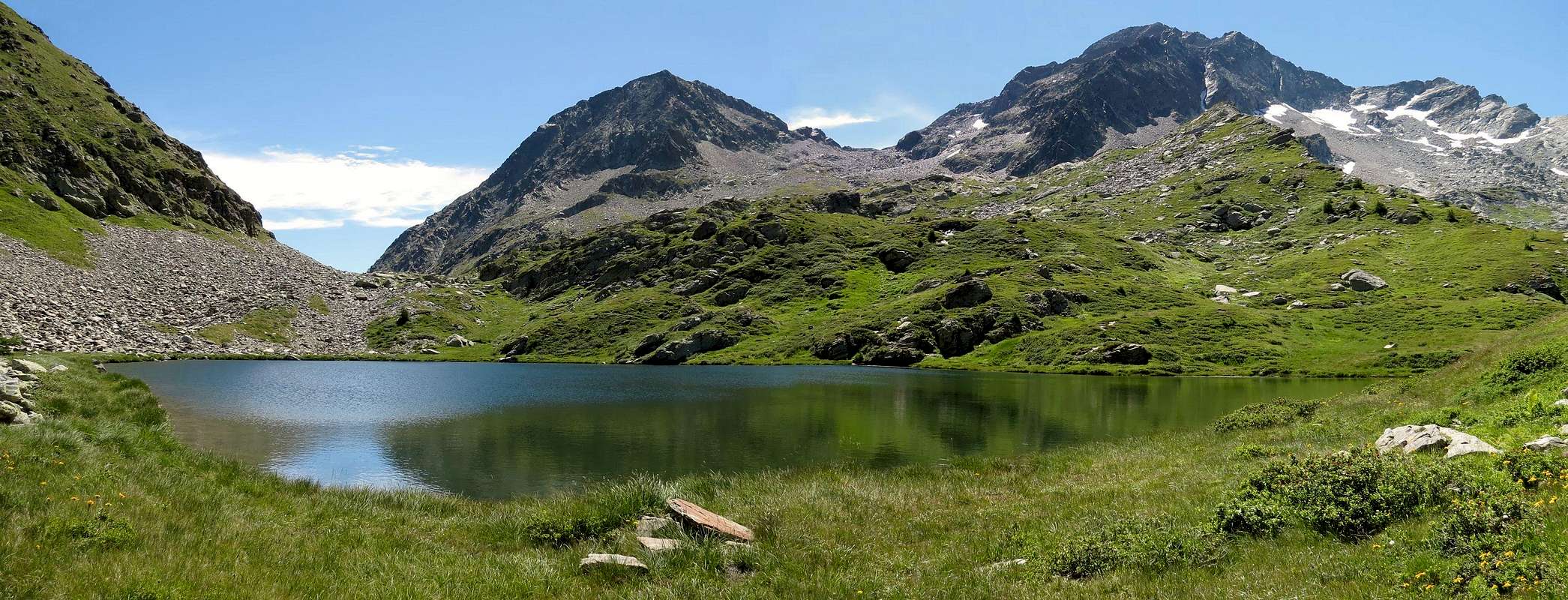
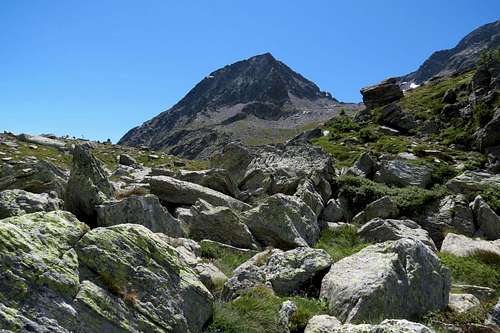
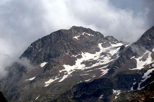
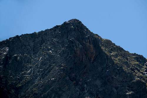
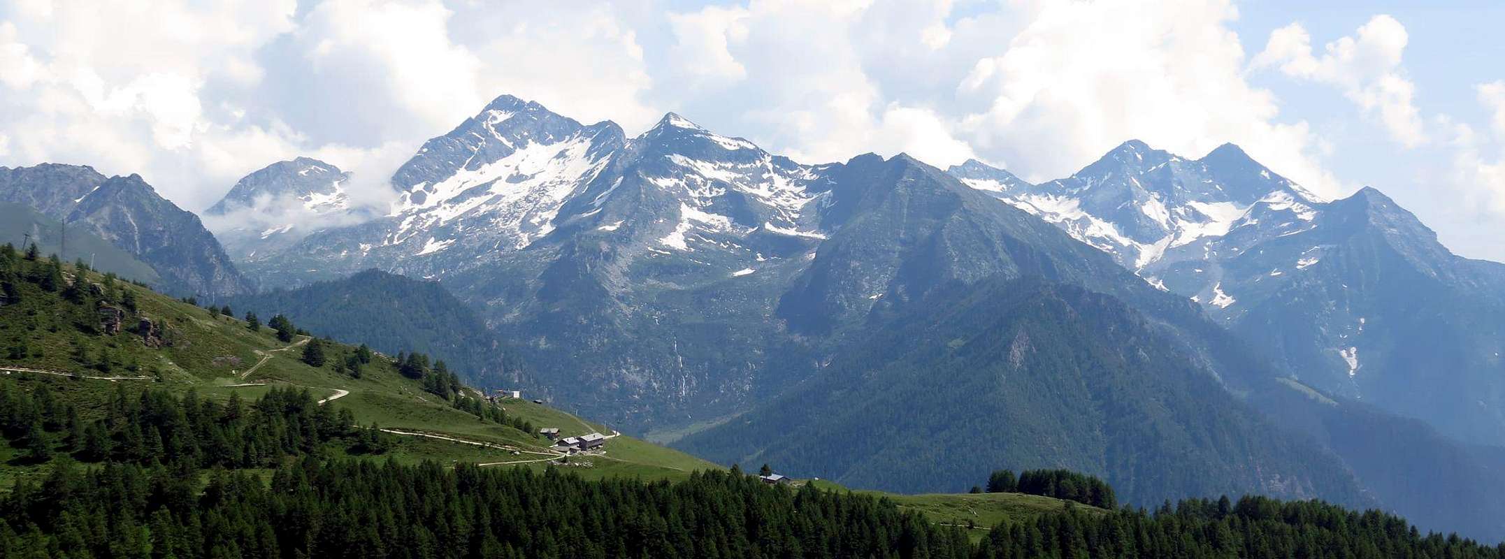
Beautiful and little known mountain located at the end of North-northeast buttress descending from Mont Nery or Becca Frudiera (3.075m) in the direction of the pass, also known as Frudièrecoll (2.271m), where the dividing ridge between the Valleys of Ayas and Gressoney stands up to the West and, forming in succession the Mont Taf, Mont Taille, Mount Rena and the Punta Regina, reaches the most well attended Ranzola Hill (2.170m). This area of mountains is poorly attended and visits are more aimed at the beautiful two Lakes Frudiera than to the Summits; this also applies to the Mont Nery, who dominated this area, over which, however, presents difficult walls and ridges. The Marienhorn or Corno Maria comes from Frudière Pass as beautiful triangular pyramid with a large North Face, yet not ascent, which falls on the Valley of the Forca into the Gressoney Valley and above the Village of Pont Trenta (1.158m). On this side also drops another, not very high but bristling wall facing East, while on the other side goes down a wider and less steep Face West over a small valley bounded by the watershed and the North Ridge Mont Nery. Seen from the North appears as imposing rocky horn, but the presence of the nearby Nery resizes greatly. Its Northern Face falls on the path that climbs the Forca Vallon but the danger, due to the numerous falls of stones, made sure that the same was closed as a precaution already by the beginning of 2000. From the Guide C.A.I./T.C.I. "Monte Rosa", 1991 by Gino Buscaini are not ascents to the Summit. For which reason the first climbs, at least known, are those carried out by Osvaldo Cardellina and Marco Cossard July 18th, 1977 via the North-northwest Edge from Frudièrecoll and that always by Osvaldo Cardellina and Marco Cossard June 25th, 1995 with uphill from the West and downhill via the Southwest Ridge, coming from Ranzola Hill with complete traverse of the ridge as we said above. But it could have been previously visited. From The Summit beautiful views toward the Northeast in the direction of the Monte Rosa Mountain Chain, while in the South the view is somewhat limited by the pyramid of Mont Nery. In addition to the East and West parallel unusual views of the divide between the Lys Valley and Piedmont and Valtournenche, or Valley of the Marmore Torrent, and the Ayas Valley or of the Evançcon Torrent.
Bella e poco conosciuta montagna sita al termine del contrafforte Nord-nordest che scende dal Mont Nery o Becca di Frudiera (3.075 m) in direzione dell'omonimo passo, conosciuto anche come Frudièrecoll (2.271 m), dove la cresta spartiacque tra le Valli di Ayas ad Occidente e Gressoney si rialza e, formando in successione il Mont Taf, il Mont Taille, il Monte Rena e la Punta Regina, raggiunge il ben più frequentato Colle della Ranzola (2.170 m). Questo settore di montagne è scarsamente frequentato e le visite sono maggiormente rivolte ai bei due Laghi di Frudiera che non alle Sommità; questo vale anche per il Mont Nery, dominatore di questa area sopra la quale presenta però difficili pareti e creste. Il Marienhorn o Corno Maria si presenta dal Colle di Frudière come bella piramide triangolare con una grande Parete Nord, ancora inaccessa, che precipita sul Vallone della Forca nella Valle di Gressoney al di sopra del Villaggio di Pont Trenta (1.158 m). Da questa parte inoltre lascia cadere un'altra, non molto alta ma irta, parete rivolta ad Est, mentre sul versante opposto scende un più largo e meno scosceso Versante Ovest sopra un valloncello delimitato dallo spartiacque predetto e dalla Cresta Nord del Mont Nery. Visto da Settentrione appare come imponente corno roccioso, ma la presenza del vicino Nery lo ridimensiona notevolmente. La sua Parete Nord cade sopra il sentiero che sale il Vallone di Forca ma la pericolosità, dovuta alle numerose cadute di pietre, hanno fatto sì che il medesimo venisse chiuso a scopo precauzionale già dallo inizio del 2000. Dalla Guida C.A.I./T.C.I. "Monte Rosa", 1991 ad opera di Gino Buscaini non risultano ascensioni alla Sommità. Per la qual cosa le prime salite, per lo meno note, risultano quelle effettuate da Osvaldo Cardellina e Marco Cossard il 18 Luglio 1977 tramite lo Spigolo Nord-nordovest dal Frudièrecoll e, sempre da parte dei medesimi, quella del 25 Giugno 1995 con salita da Ovest e discesa tramite la Cresta Sudovest, arrivando dal Colle della Ranzola con traversata completa della precedente suddetta cresta. Ma potrebbe essere già stata precedentemente visitato da altri. Dalla Vetta belle vedute verso Nordest in direzione della Catena del Monte Rosa, mentre a Mezzogiorno la vista viene alquanto limitata dalla piramide del Mont Nery. Inoltre ad Oriente ed Occidente inusuali viste sui paralleli spartiacque tra Valle del Lys ed il Piemonte e Valtournanche, o Valle del Marmore, e Valle di Ayas.
Firts Ascents
First on the Summit: Osvaldo Cardellina and Marco Cossard, Jul 18th, 1977.
In winter: Unknown.
West Slope: Osvaldo Cardellina and Marco Cossard, Jun 25th, 1995, in ascent from Frudièrecoll.
North-northwest Edge: Osvaldo Cardellina and Marco Cossard, Jul 18th, 1977, in ascent and descent from and to Frudiera Pass.
Southweest Crest: Osvaldo Cardellina and Marco Cossard Jun 25th, 1995, in descent towards Saddle 2.680/90m and upper or second Frudière Lake.
Great traverse from Ranzola Pass, Punta Regina, Mounts Rena, Taille and Taf, Frudièrecoll, Marienhorn: Osvaldo Cardellina and Marco Cossard, Jun 25th, 1995.
Getting There
BY CAR:
From Torino, Milano, etc: Motorway A5. Exit Verrès for then to continue on SR.26 for Champoluc Valley.
From Switzerland: through the Grand Saint Bernard Tunnel or the namesake pass. Drive to Aosta, Verrès and Champoluc Valley.
From France: through Mont Blanc Tunnel or Petit Saint Bernard Pass. It isn't necessary to take Motorway A5: you can drive on SS.26, in the direction of Aosta and Verrès.
BY PLANE:
Aeroporto "Corrado Gex" Saint Christophe (Aosta).
SPECIFIC ROAD to Graines Hamlet and Frudière Vallon: from Verrès Municipality go up through the Regional Road passing Challant Saint Victor (765m; St. Massimo or Mémo Chapel) and Saint Anselme (1.060m; Quintum Locum Roman) Communes; continue North up to the Arcesaz Village (1.146m; Chapel of Saint Giacomo of the XII° Century). From this, leaving northwest the previous route to Brusson Municipality, through a Municipal Road before to the Southeast reaching Curien Village (1.245m), after in Northeast to Graines Village (1.383/96m), with its ancient Castle with beautiful squared tower, on rocky-wooden promontory in altitude 1.313 meters and clearly visible from everywhere.
STRADA SPECIFICA per Graines ed il Vallone di Frudiera: dal Comune di Verrès salire con la Strada Regionale passando i due Comuni di Challant Saint Victor (765 m) e Saint Anselme (1.060 m; Quintum Locum Romano); proseguire in direzione Nord fino al Villaggio d'Arcesaz (1.146 m; Cappella di S. Giacomo XII° Sec.). Da questo, lasciando a Nordovest il percorso precedente verso il Comune di Brusson, continuare tramite una Strada Comunale, prima verso Sudest raggiungendo il Villaggio di Curien (1.245 m) e subito dopo a Nordest in direzione di Graines (1.383/96 m), dominato dall'antico castello con bella torre squadrata su d'un promontorio a quota 1.313 metri, ben in vista da ognidove.
Approach
From Graines Village: follow the farm road along the Graines Valley, keeping the Northern side of the torrent, up to the fork 1.508m where you can enter a short cut that crosses it leading to the Charbonniére Pasture (1.628m); cross the Pastures of Restoly (1.682m), Champcharlec (1.766m) and Frudière (1.849m), walk along the right side of the Lower Lake of Frudière (2.035m; 2h'00), moving towards a promontory with unnamed and semi ruined pasture (Upper Frudière? 2.139m). Ascend the steep slopes to get the Upper Lake of Frudière (2.230m) and from this in short time and through a small path always n° 9 to the Frudière Pass or Frudièrecòll, below the North Face of Marienhorn (2.265 m; 3h'00/3h'30 Graines).
Important note: at present the path, concomitant with the farm dirt road that runs through the Vallon of Frudiera is closed due to a landslide still unsafe, almost immediately after the Graines Village up to the Alp Frudière. To access the lakes you have to take the next Estoul's Vallon to Barmasse Pasture (2.083m), just below the Ranzola Hill, and then turn South on the trail n° 9A overcoming the large saddle 2.163 meters and descend towards Alp de la Garda (2.072m) and then navigate to the Lower Lake Frudiera.
Dal Villaggio di Graines: seguire la strada poderale lungo il Vallone di Graines a Nord dell'omonimo torrente sino al bivio 1.508 m, dove una scorciatoia lo guada e porta all'Alpe di Charbonniére (1.628 m); superati gli Alpeggi di Restoly (1.682 m), Champcharlec (1.766 m) e Frudière (1.849 m) costeggiare sulla destra il Lago Inferiore di Frudière, doppiandolo a Nordest (2.035 m; 2h'00), portandosi verso un promontorio con alpeggio senza nome sulle Carte (Frudière Damon? 2.139 m) e semi diroccato. Risalire il ripido gradone che porta al Lago di Frudière Superiore (2.230 m) e da questo in breve tempo con un sentierino, sempre n° 9 al Passo di Frudière, sottostante il versante Nord del Corno Maria (2.265 m; 3h'00/3h'30 da Graines).
Nota importante: allo stato attuale il sentiero, concomitante con la strada poderale, che percorre il Vallone di Frudiera é chiuso, causa una frana ancora pericolante, da quasi subito dopo il Villaggio fino all'Alpe di Frudière. Per accedere ai laghi si deve percorrere il successivo Vallone di Estoul fino all'Alpe Barmasse (2.083 m), sottostante il Colle della Ranzola, per poi deviare a Sud con il sentiero n° 9A superando la larga sella 2.163 metri e scendere in direzione dell'Alpe de la Garda (2072 m) per poi traversare verso il Lago Inferiore.
Route
From immediately below the Frudièrecoll (*** also prior to Lake Superior Frudiera turning decidedly in the Southeast in the direction of the collar-saddle between Marienhorn and Mont Nery), continue towards the South-southwest in a small valley between scree and snowfields residues passing below the Western slope until reaching, bending progressively to the right (Southwest) in the direction of a much more extensive snowfield that salt towards the North Face of Mont Nery followed by a clear and wide saddle in around 2.680/90 meters, which can be reached with a small couloir debris or snowy of about 30-40 meters in the final part. From this and turn left (East) and on short tracks and debris you can reach four small prominences that are beyond easy, coming to the real base of the Southwest Ridge. Overcome a steep section of around 25 meters to reach a small double terrace in front of a wall nearly vertical of around 15/20 meters, followed by two lower elevations. This hovers to the left (North) on the back edge of the ridge, at a small notch between the two, above the second terrace a much more broad and flat. This stretch can also pass on the opposite side of steep cliffs and exposed in the Southeast. The next hop of a dozen meters is faced with steep wall on the left followed by a narrow oblique ramp that goes from right to left (AD/AD-/III°+/PD+; III°/III°-/II+; very exposed to the Northwest with rock pretty good) getting to the terminal, where the ridge becomes more regular and continuous; overcoming several small bumps, alternating with a series of small notches (I°+ / II°- on the edge of the ridge), can be reached fairly easily the Top (1h'15/1h'30 from the pass; 3h'00/3h'30 from the Village of Graines).
Da immediatamente al di sotto del Passo di Frudière (*** oppure antecedentemente dal Lago Superiore di Frudiera deviando decisamente a Sudest in direzione del colletto-sella tra Marienhorn e Mont Nery), continuare verso Sud-sudovest in un valloncello tra sfasciumi e nevai residui passando al di sotto del versante Ovest sino a raggiungere, piegando progressivamente verso destra (Sudovest) in direzione di un ben più esteso nevaio che sale verso la Parete Nord del Mont Nery seguito da un evidente e larga sella in altitudine 2.680/90 metri circa, alla quale si arriva con un canalino detritico o nevoso di circa 30/40 metri nella parte finale. Da questa volgere a sinistra (Est) ed in breve su tracce e detriti si raggiungono quattro piccole asperità che si oltrepassano agevolmente, arrivando alla vera e propria base della Cresta Sudovest. Superare un tratto più ripido di circa 25 metri raggiungendo un doppio terrazzino con di fronte un muro quasi verticale di circa 15/20 metri, seguito da due minuscole elevazioni. Questo si aggira a sinistra (Nord) ritornando sul filo di cresta, presso un intaglietto tra le due, sopra un secondo terrazzo molto più largo e piatto. Questo tratto si può oltrepassare anche dal lato opposto su rocce ripide ed esposte a Sudest. Il salto successivo di una dozzina di metri si affronta sulla sinistra tramite rocce ripide seguite da una stretta rampa obliqua che sale da destra verso sinistra (AD/AD-/PD+; III°+/III°-/II°+; molto esposto a Nordovest con roccia abbastanza buona) arrivando alla parte terminale, dove la cresta diventa più regolare e continua; superando diverse piccole asperità (I°+/II°- sul filo di cresta) si raggiunge abbastanza facilmente la Cima (1h'15/1h'30 dal colle; 4h'30/5h'00 da Graines).
Difficulty
The route can be classified as EE/A from F+ a PD-/PD+.
L'itinerario è classificato EE/A from F+ a PD-/PD+.
Gear
For Hiking, preferably with rope.
Da Escursionismo, meglio se con corda.
Campings
Remember that free camping is forbidden (except for emergency reasons, over 2.500m, from darkness until dawn).
Mountain Conditions
You can get meteo information at the official site of the Regione Valle d'Aosta:
Parents refers to a larger category under which an object falls. For example, theAconcagua mountain page has the 'Aconcagua Group' and the 'Seven Summits' asparents and is a parent itself to many routes, photos, and Trip Reports.

 4072 Hits
 84.27% Score
 18 Votes