Toggle navigation
Mountains
Routes
Images
Trip Reports
Forum
What's New
People
Areas & Ranges
Articles
Trailheads
Canyons
Huts & Campgrounds
Albums
Logistical Centers
Fact Sheets
Lists
Custom Objects
Gear
Plans & Partners
WELCOME TO SUMMITPOST
SIGN IN
REGISTER
Little San Gorgonio Peak
Additional Parents
Image
Little San G Topo
View High-Resolution Image
Little San G Topo
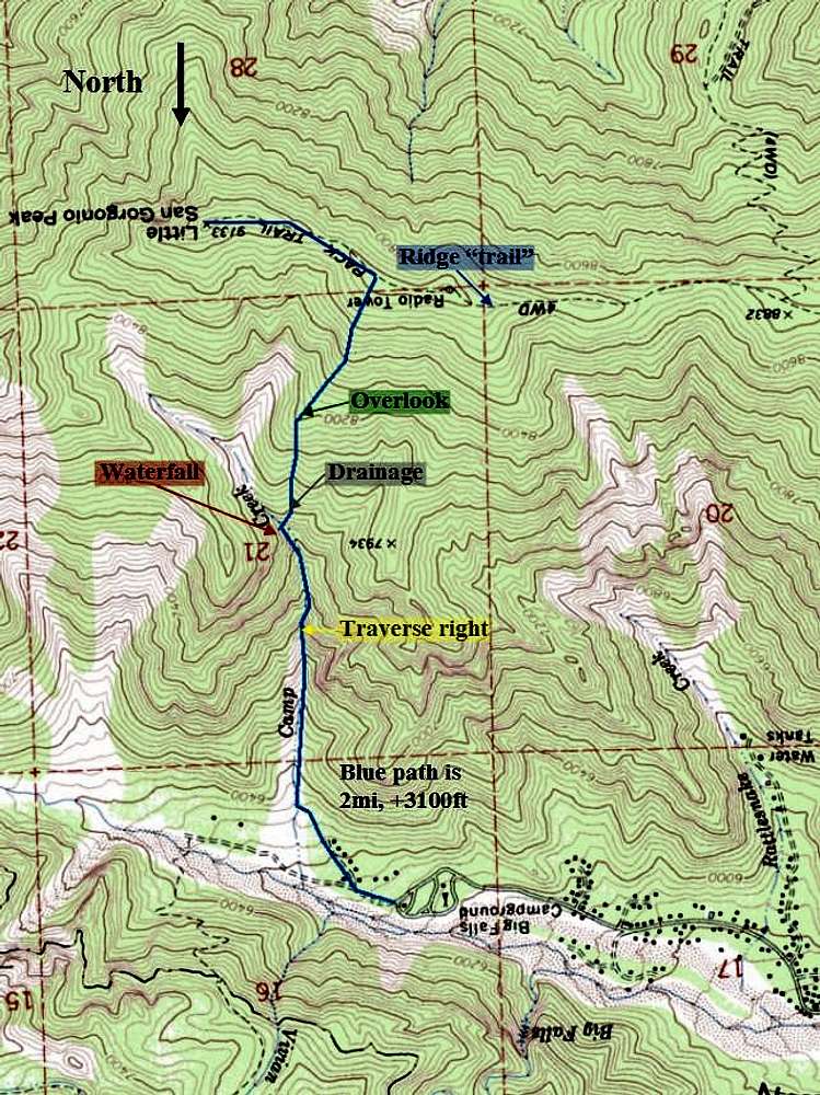
The blue line shows my route up camp creek. The first waterfall is at "traverse right." I followed the drainage above the second waterfall ("waterfall").
« PREV
NEXT »
CookieMonster
on
Jul 28, 2007 8:03 pm
Comments & voting
Other parents
Lat/Lon:
34.10060°N / 116.8278°W
Image ID:
317291
4451 Hits
71.06
% Score
1
Votes
Log in to vote
Comments
No comments posted yet.
to post!
Don't have an account?
Little San Gorgonio Peak
(Mountain/Rock)
« PREV
Viewing
#5 of 12
GALLERY
NEXT »
CookieMonster's Image Gallery
« PREV
Viewing
#43 of 50
GALLERY
NEXT »
×
You need to login in order to vote!
User Name
Password
Remember me
Forgot your password?
Log me out when I close my browser.
Keep me logged in all the time.
sign in as a user
Don't have an account?
Register now for FREE
Rating available
Suggested routes for you
People who climb the same things as you
Comments Available
Create Albums
Register Here


