
Comments
No comments posted yet.
|
|
Trip Report |
|---|---|
|
|
43.20100°N / 109.6726°W |
|
|
Jul 25, 0000 |
Several months ago, fellow high pointer Dave Covill was putting together a team to go up Gannett Peak in late July 2020. I was sitting at 47 contiguous US high points and only needed that one to complete the lower 48 high points list. What’s more, he said we’d have horses carrying our heavy stuff and they would cook meals! Very attractive as I was not looking forward to carrying 50lbs worth of gear over 60+ miles (nor was I a huge fan of dehydrated meals). Due to Covid, all of other my travel plans fell through, so I asked if I could join the team. I would be the 10th person.
I caught a ride with fellow climbers Rob and Robyn from an exit off of I25 north of Denver. We drove for several hours through northern Colorado then Wyoming until we got to Dubois, a town on the east side of the Wind River Range. We met the rest of the team: leader Dave, Hilary, Julie, Lizzie, Jill, Laura and James. We unloaded the bulk of our gear at the horse packers’ house and went for dinner. This is going to be interesting.

We geared up and started on the Glacier Trail heading south. The walk is pretty straightforward, past a big waterfall, through the thinning woods until we came out about 2 miles north of Arrow Pass. As we departed tree line, the scenery started to open up. It seemed very hot and dry and there was hardly a cloud in the sky. The trail was gentle and easy to follow. After a while we arrived at Arrow Pass, at just under 11k, a great place to stop and take a rest break.

After a short while, we headed down, eventually into a zone of burned trees and eventually into the trees again. The highlight of this portion of the hike was a series of blue green lakes-Phillips, Double and Star-that are allegedly full of golden trout. After Star Lake, one descends roughly 1000’ past Honeymoon Lake to Downs Creek. I would not call that wide and rushing body of water a mere “creek”!

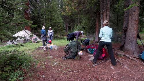
Eventually, we ended up at a spot where would have to cross it. There was a bridge, yes, but some fording was also called upon. We took our shoes off, rolled up our pant cuffs and waded through the ice-cold glacial river: surprisingly pleasant and refreshing for tired feet. At this point we had been hiking for nearly 16 miles and had about another 4 miles to go to get to the Stetter Ranch, where we would spend the night. Towards dinner time, I saw the sign for the junction of the Ink Wells Trail, where the Stetter Ranch is located (20 miles in). Tired but delightfully happy at having reached our destination, the Stetters cooked us dinner and had us set up tents in a beautiful meadow.

The Stetters run a horse packing business taking hikers and fishers up into the Wind River high country to partake in their hobby. They employ a group of special forces veterans who are training to be horse packing guides. Real eye candy for the ladies is all I can say. After a bit, the horse and mule train came in with our stuff and we were off to sleep.
This was a short day as we hiked roughly 3.5 miles to the top of Wilson Meadows, where we would set up our second camp. The hike was straightforward with very little elevation gain except for ONE interesting feature. At one point we had to cross Klondike Creek. The trail and my track said to go higher along the creek to a point where it was almost a waterfall. The only sensible place to cross it was over a thick log. Yikes! Brave Dave walked across; most of us sat down on it and scooched across. I could feel my adrenaline spike and my hands start to shake but I made it across. It took a good while for the fear and adrenaline to leave my system.

We arrived at camp 2 by midday and had the rest of the day to rest, eat and set up tents. Dave and Hilary prepared a delicious dinner. They brought metal tables, plates, coffee pots and a cheese grater, among other necessities for a climbing trip. This was my kind of camping! With full bellies and rested legs, we went to sleep.
I woke up at 5am to the pitter-patter of rain on my tent walls. Water started to collect on the floor of my tent. Not good. I scrambled to pack up my sleeping bag, pad, clothing, everything into my duffel and rushed into another tent that didn’t leak. The rain let up for long enough for us to eat and pack up our big backpacks for the hike to high camp. I could tell that this was not going to be my favorite day.
The trek to high camp involved crossing roughly 16 streams, some of which had logs you needed to walk across. Stream crossings were my nemesis: I was willing to even ford a stream risking wet boots and socks instead of walking across those logs, but Dave wouldn’t let me. I would have to face my fear and just walk across those darn logs with an awkward pack. Somehow, I gathered enough courage to cross those logs without falling in: victory! The rest was easy, right? The end of the stream crossings meant we were above treeline and could see the sky better. The forecast called for 30% rain, which means, probably nor rain? I don’t know, it’s black magic.
We pressed on until we got nearer to the glacier. What do glaciers deposit at their terminus? Boulders.. big ones, lots of them! We would have to spend the next two hours or so (I lost track of time) winding our way through a boulder field with awkward packs. Peachy. Then it started to rain. Double peachy. By the time we arrived in high camp, everything was soaked, we were cold and there was nothing with which to make a fire. The sky still hadn’t cleared up. It didn’t look good for summit day. Just to make sure Dave wasn’t insane, I asked him what he’d do if it was raining in the morning and he gave the sensible answer.

We woke up around 5am: at least it wasn’t raining! We couldn’t see the mountain tops as they were socked in, but the forecast was for only 10% rain in the morning (and 30% in the afternoon), grudgingly good enough to go. I felt quite refreshed: I had recovered from my mentally exhausting day the day before.

The hike up was a constant flurry of bare boot to crampon transitions: starting on a shallow snow slope, then up a steep rock slope, then a steeper snow slope, more rocks, then rope up in teams of three. I was on a rope team with James (leading) and Lizzy (behind me). James had done a number of glaciated peaks and had lots of snow travel experience. Lizzy was also very proficient. I was glad to be in good company. James led us over the snow bridge between the two crevasses that had formed over time. We had two other rope teams that made it successfully to the top of the bergschrund.

Next was an even steeper rock pitch to the summit ridge. The summit ridge (around 13.2k) started off as a nice, not terribly steep rock field. Then it was back to crampons and rope teams. We could not see much around us at this point as we roped up again. James postholed through a steep looking snow section and we followed.

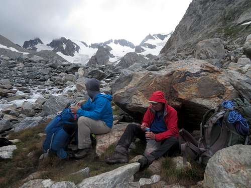
Then, the slope seemed to level out. We passed some other climbers and were quickly at the summit. All nine of us made it. The sky cleared up and we could see all around. The sun even came out for a bit. As one would expect, the views are spectacular. The Wind Rivers are a very rugged, wet range. On a clear day one can see all the way to the Grand Tetons (not today!)


After the usual pats on the back, summit selfies, drinks and snacks, it was time to go down. We roped up and followed the ridge; then went down the steep section that James post holed. At this point, the fog had lifted and we could actually see down. If any one of us fell at this point, we would all slide down and fall of the mountain. It was that sketchy. Sometimes it is good to have low visibility just for peace of mind. Everyone uttered a big sigh of relief when we came back down to Gooseneck Pinnacle where we would set up a rappel station to go down over the bergschrund.

There were nine of us, so the going was very slow. Rob, the guinea pig, went first and set up the anchor and second rappel station just above the bergschrund. I was one of the last people rappelling down. As I got onto the second rappel, I heard a clap of thunder and Hilary yelling “get off the f***ing mountain!”: lightning had struck not too far away. I felt a surge of adrenaline and rappelled as fast as I possibly could. Fortunately, the weather was decidedly moody which meant that the thunder and lightning also moved on as fast as it could.
We had one more steep snow section to get down. It was a bit nerve wracking as I was first on the rope team. I fell a few times, but the snow was pretty grippy and my rope team caught me. It wasn’t particularly dangerous even I believe.. kind of fun even. We had to navigate another rock section and the final shallow snow slope before our tents. Finally, we got back to our tents, absolutely ecstatic and exhausted from an adventurous climb. Like in the movies, the sun came out and the stress melted away.
Here's a visual of our climbing route

We woke up to a cold but incredibly beautiful sunny morning. We had to rush back to upper Wilson Meadows to meet up with the horses and cowboys who would take our heavy stuff back to the Stetter Ranch. First thing, we were back into the boulder field again on tired legs. This time, we took a more direct route and it was mercifully much shorter than it was two days prior. Boulder field over, it was time to cross streams again. The same logs from two days ago were much softer, so it was easier to get purchase. That or I had somehow magically mastered log crossings, but it felt much easier and kind of fun even.

By midday, we were back at the Stetter Ranch. The rest of the afternoon had all the elements of the ultimate vacation day: warm sun, swimming in the cold glacial stream, good food, playing with the ranch puppies, good conversation. It was a truly spectacular way to end an adventurous trip.

Only it wasn’t quite over. We still had to hike 20 miles back to the trailhead. Fortunately, the horses again took our heavy stuff and we were hiking with day packs and light trail shoes. Once in a while my “trail legs” come to life. That’s where you can hike extremely long distances on minimal effort. This was such a day. I felt like I had wings. I raced past Downs Creek, up Honeymoon Pass, past the gorgeous lakes, up Arrow Pass, where I took a long break.

I took most of my clothes off and sunbathed for a good while.

I made great time on the last 7 or so miles down to the trailhead. The rest of the crew followed. We ended the day at the Lone Buffalo steak house in Dubois. What a day.. what a trip.
The final stats were: about 61 miles round trip and 12k+ feet of gain.