
-
 1884 Hits
-
 74.01% Score
-
 4 Votes
|
|
Canyon |
|---|---|
|
|
Hiking |
|
|
Summer, Fall |
|
|
Overview
The Beaver Creek WSA & SWA + surrounding areas south of Pikes Peak are hands down the most rugged and isolated wilderness areas anywhere along the Front Range. Densely forested, topped with rocky crags, almost road and trail less with many parts being an impenetrable wilderness few human beings have probably ever set foot in. The only thoroughfare in this wilderness are the canyon systems of the West & East Beaver Creek, winding their way down from the high mountains to the Arkansas Valley.
East Beaver Creek Canyon has a very different character than its larger brother to the West. It has maybe a third of its volume, its valley bottom is really only the creek itself and it is even more remote.
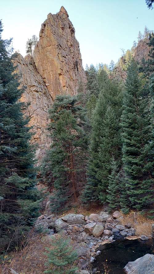
 East Beaver Creek Canyon - Entrance
Getting There / Route
Getting there:
From Canon City, go 8 miles E / from Penrose go 4 miles West on U.S. HWY 50 to HWY 67 (Phantom Canyon Rd.), then go N 2 miles to CR 123, then E 0.2 miles to CR 132, and then N 9 miles to the parking lot at the end of the road
Route:
WARNING:
This is an extremely challenging route ! Only attempt it if you are very experienced and have the stamina to navigate trail less and very rugged areas for hours on end
There is no exit route at all except the canyon. The entire route except the Narrows is 100 % covered with dense canopy. Any Search & Rescue Mission would take a lot of time and would be very challenging. This is an extremely isolated and hard to navigate area, hardly ever visited by anyone.
I highly recommend to climb the canyon up and not down. Distance to the lower entrance of the canyon is a lot shorter than to the upper end and the first couple hundred yards will give you a very good idea of what is ahead of you. If that is not to your liking, turn around - it only gets worse.
From the parking lot walk 0.75 miles, the smaller path leading off to the right of the dirt road is actually the main path. Turn left on the next junction. Eventually the trail will descend down to the creek close to the confluence of West and East Beaver Creek. The trail crosses a meadow right before it starts to climb up the hill to turn sharp East, from here a faint trail ( marked by a couple rocks) turns to the left. Trail will cross Beaver Creek and lead you to the confluence of West & East Beaver Creek.
Trail leads another 100 ft up East Beaver Creek and dissapears into the underbrush. This is will be the last trail you will see for hours from now on .
LOWER SECTION:
East Beaver Creek is considerably smaller than West Beaver Creek. It winds its way in a narrow but shallow V- shaped valley into the mountains. Often the creek is the best thoroughfare, but fallen trees constantly force you onto its sides, sometimes into open pine forest, more often into dense gamble oak, willows and thorn scrub.
INNER SECTION:
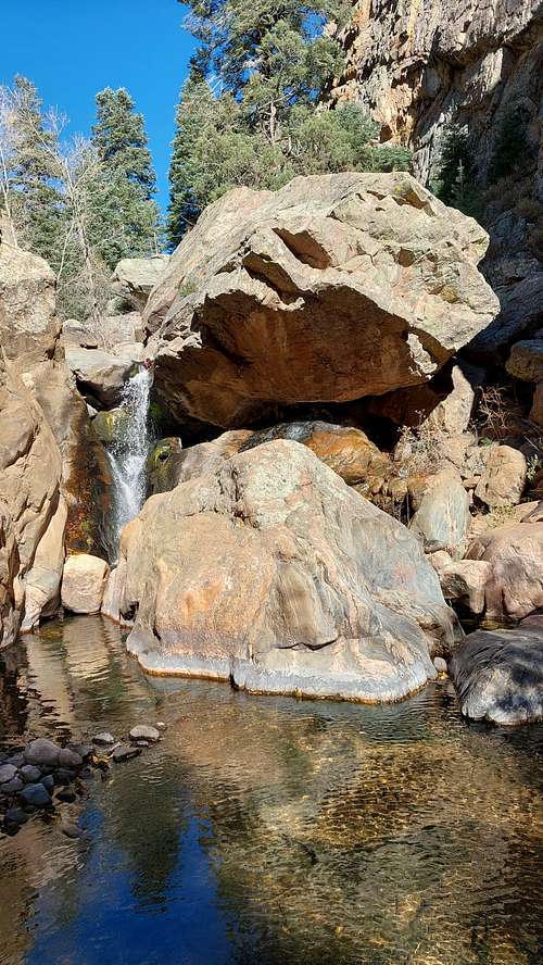
The entrance of the first canyon is marked by a small waterfall, which can be easily bypassed on its right side. The canyon runs almost straight in a northwestern direction, with vertical 300 ft high walls on each side. The valley widens after that, with crags, towers and rock faces of the very isolated Crown Hill high above. The next canyon is almost W- shaped, again with 300 ft high vertical walls.
UPPER SECTION:
You still need to continue climbing in and along the creek bed surrounded by dense canopy. Eventually you will see a high yellow rock face ahead of you, sticking high out of the canopy. The top of the rock face marks the exit out of this canyon. Underneath the rock face the canyon widens into a funnel and the forest becomes a lot less dense. Hike up to the rim and soon you will stand out in the open of the cow pasture extending behind the rock face. You made it !
Cross the creek and you will be able to pickup the spurs of Trail Gulch Trail. The trail is in its beginning an old 4 x 4 road, running high above East Beaver Creek Canyon. It eventually turns into a trail, merges with Powerline Trail and leads you back to the parking lot.
 East Beaver Creek Canyon - Narrows1
Red Tape / Dangers / Season
The canyon is entirely inside the Beaver Creek SWA ( State Wildlife Area). Colorado State Laws requires that anyone 16 years and older needs to be in possession of a valid Colorado fishing license to enter a SWA.
East Beaver Creek Canyon is an extremely remote and rugged area. Get a very early start to make sure you are out of the canyon during daylight. Going is very slow and tedious. Canyon may be subject to flash floods. The two narrows inside the Inner Section offer few easy escape routes in case of flooding. You are on your own inside the canyon. A rescue mission would be a very long and complicated process.
By far best season is later in fall when the creek is low and danger of flash floods is close to zero. Summer has the advantage that there a number of nice pools along the way to cool off + longer day light hours to be under less time pressure.
Spring run off may close the narrows entirely and would prevent you from using the creek off and on as thoroughfare.
Deep snow in winter combined with dense scrub would really make this an extremely hard trip - that's only for you if you are a glutton for punishment.
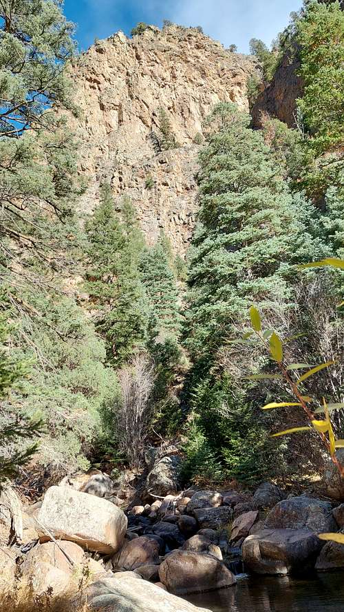 East Beaver Creek Canyon - Narrows
Camping
Beaver Creek SWA is day use only. The most suitable camp sites outside the SWA are north of the cow pasture on top of the canyon.
See map for SWA boundaries: Beaver Creek SWA map
There is only one single spot suitable for camping on the trail back to the parking lot about 2/3 down. Otherwise you really would have to camp on the old 4 x 4 itself to find any kind of level ground.
If you are forced to make an emergency bivouac inside the canyon, make sure to camp high enough to avoid any danger of flash floods.