-
 7325 Hits
-
 0% Score
-
 0 Votes
|
|
Mountain/Rock |
|---|---|
|
|
0.21055°S / 78.28567°W |
|
|
Hiking |
|
|
Spring, Summer, Fall, Winter |
|
|
11493 ft / 3503 m |
|
|
Overview
Coturco is a 3,503m(11,493ft) mountain directly to the east of Pifo, Pichincha, within 20 minutes of the new Mariscal Sucre Airport. Coturco's intriguing summit formation, known as "La Cabeza de León" (Lion's Head), is a landmark that can be from spotted from miles away. It is a nice 5-7hr round-trip hike from the town of Pifo and is a well kept secret, seldom hiked by tourists. On weekends, locals often drive up to the summit in their own vehicles to enjoy the views and if asked, will typically provide free transport back to Pifo.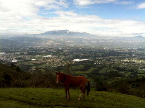
Vista over the Pifo and Tumbaco valley towards Quito and Volcán Pichincha
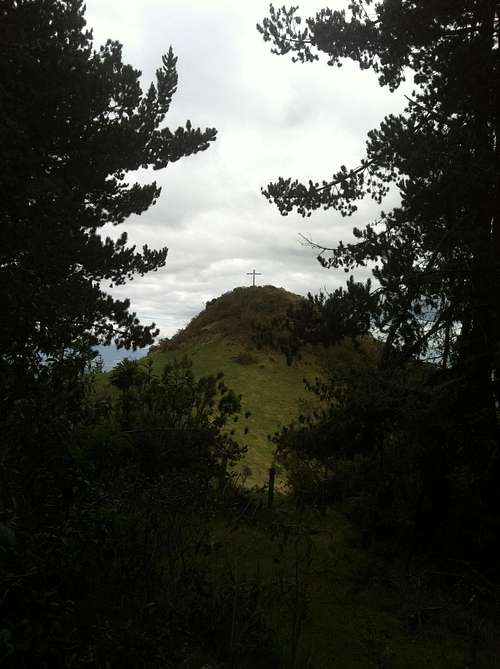
La Cabeza de León, the distinct, rounded summit formation of Coturco
Getting There
From Quito's Rio Coca bus terminal, Pifo can be reached by catching any green bus ($0.55) that is heading to the following final destinations: Pifo, Yaruquí, El Quinche. The express bus that goes all the way from Quito's Rio Coca or Quitumbe bus terminals to the Nuevo Aeropuerto costs a bit more but is often worth the price because it does not stop near as much. Regardless of which bus you catch, get off at the Pifo stop. They will let you off at the main highway, you simply walk uphill on the main street (Gonzalo Pizarro) that is lined with stores and bakeries. After 3 or 4 blocks you will arrive to the central park of Pifo. From the central park, the simplest way to get to the trailhead is to get a taxi ($1.50/$2.00) to take you to the Setecientas Gradas (700 Stairs). If you would like to make the 20 minute walk to the 700 Stairs, then walk across the central park plaza towards the church/cathedral. When you are facing the church, turn left and walk downhill, passing the local government building (junta parroquial) on your left, then the mercado, then the escuela. Curve around to the left passing the soccer stadium on your right. Turn right past the soccer field and follow the cobblestone road uphill for a kilometer or so. You will stay on this road the rest of the way. However, you will reach a large clearing where they are constructing a new large highway, simply walk straight across the highway construction and continue down the dirt road. Keep walking straight down this level dirt road until you reach the trailhead landmark, the well-known "Setecientas Gradas" (700 Stairs). At any point you are unsure of the path, simply ask a local "Dónde están las Setecientas Gradas?" and they will gladly point you in the right direction. ![Las Setecientas Gradas]()
The 700 Stairs
The 700 Stairs
Route
Go down the 700 Stairs and ascend the other side. From here to the Coturco summit should take approximately 2.5 to 3hrs. After crossing to the other side of all the stairs, start walking down the road to the left. Eventually it will curve around to the right alongside a concrete wall. Take a right at the intersection of dirt roads. Now continue walking uphill on this road past several country farms and grazing cattle on your left. As you go up, the dirt road starts to turn into a narrower, packed dirt hiking trail. Occasionally the trail narrows and becomes slippery with mud in which case you can simply slip under the easily passable barb wire lining the side of the trail, hike through the pastures to get around the muddy portions, and then re-enter the trail. After an 1hr to 1.5hr you will see the Lion's Head come into view. Nearing the end of the hiking trail, about 30 minutes from the summit, you will walk past a small house and eventually hit a dirt road for cars. Turn right on this dirt road and walk up for a couple minutes, nearing the pine forest. Do not walk past the pine forest. Turn left just before you reach the pines, possibly slipping under some more barbed wire and hike straight up towards the Lion's Head, which is topped with a large cross. If you walk far enough up the road to see a green sign that says Coturco, then you should backtrack just a bit to find the entrance to Lion's Head. You can also easily walk through the pine forest to arrive at Lion's Head. There is a nice campsite in the middle of the pine forest. ![View from Coturco summit]()
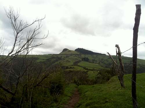
View from Coturco summit of Cerro Ilaló(left) and Volcán Pichincha in the distance
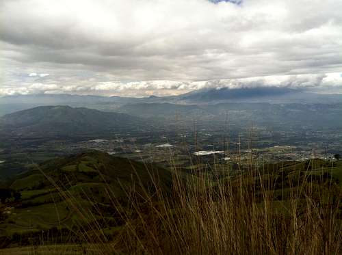
View from Coturco summit of Cerro Ilaló(left) and Volcán Pichincha in the distance
When to Climb
Great to climb year-round. As mentioned, trail can become slippery in rainy conditions. Choose a sunny or slightly cloudy day. Better to start hiking in the morning to be sure you will beat the occasional afternoon rains. But even if it does rain, it is typically rather light right. Camping
Possible camping in pine forest adjacent to Lion's Head summit.