
|
|
Mountain/Rock |
|---|---|
|
|
41.07590°N / 116.2543°W |
|
|
Elko |
|
|
Hiking |
|
|
Spring, Summer, Fall |
|
|
8791 ft / 2679 m |
|
|
Overview
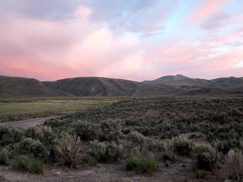
Beaver Peak Sunrise
Beaver Peak is one of the least visited peaks in the whole state of Nevada. One of the reasons is the fact that it is located totally on private property and that makes obtaining permission a necessity in order to visit this peak. Having almost 2400 of prominence makes it worthwhile to those climbers who are actively pursuing these peaks as Beaver ranks #117 on the Nevada prominence list.
The owners of the land is the giant Maggie's ranch, one of the largest in the whole state but recently the owners have been allowing access to those who will take the time and effort to visit the ranch's office during business hours on Mon-thursday. The information you need is found below under red tape. To get a flavor of this ranch, visit their Facebook page which has quite a few pictures of the ranch in action.
Getting There

Several gates to open
Take I-80 to the town of Carlin and look for the exit for highway 766 and drive north onthis paved road. A very large mine operation is found at the end of the road and you most likely will encounter lots of mine trucks, buses, and private vehicles as you drive north towards the mine. Watch for a junction where the paved road continues north, you will want the road (not paved) marked and signed for Ranches (about 11 miles from Carlin). The road is not paved but it is in great condition and stay on it until you see the Red Ranch house (about 12 miles). (I recommend using Benchmark mapbook). Just before the RRH, there is a gate that you will have to open (and close) and you drive in towards the ranch house but you will see a road that heads left up the hillside. Take that road and it'll be about 5 - 5.5 miles to where you will find our trailhead. You'll need to open and close two (maybe three) more gates. The road was in good shape but I wouldn't want to drive it in wet conditions
We found a short spur road off and drove up to another gate that we couldn't open so we parked and climbed over the fence. The distance from Carlin to the Ranches turnoffwas about ten miles and then the distance to the Red Ranch house will be provided later (I am at work and this information is in a folder at home).
Route

Starting out

Dennis
Our route went up from a gate (that we had to climb over due to not being able to open it) and we headed directly uphill toward point 7343. We encountered a fenceline that we ended up passing over and found an old Cat Track that facilitated getting up to a ridgeline just east of point 8048. From there our route was obvious and both Ken and I skirted the north side of the small peaklet of 8452 and then descended to a saddle between 8452 and Beaver Peak. Dennis elected to go over Peaklet 8452 as it has more than 300 feet of prominence. Both Ken and Dennis have posted GPS tracks which clearly show our route (on peakbagger.com). The overall stat's : Roundtrip mileage 7 Elevation gain 2800'

Ken going over 8042

The final saddle
Red Tape
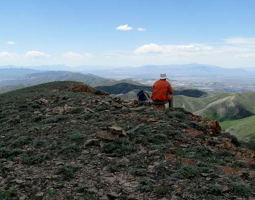
View
As mentioned in the Overview section, this peak is located on private ranchland and requires permission to be able to visit this peak.
You get the permit by stopping at the Maggie's Ranch office on the south side of I-80 (exit 292) just about ten miles west of Elko. The California Trail Information center is on the north side. Permits are only given out on mon-thur 9-12 1-4. You will need to provide information about your
vehicle(s) that will be driven on the ranch land and show a drivers license and provide address and sign a form. They were very friendly
but rarely see hikers so be sure to tell them your goal is Beaver Peak. The permit is good for a calendar year. There was no charge for the
permit.
I was treated very nicely by the manager in the office and was even thanked by him for being interested in being on their property and for seeking permission. Please don't try and stealth this peak, you probably won't get away with it and FYI, our vehicles were checked out for the permit by one of the ranch trucks while we were parked at the place we chose to be our trailhead.
When to Climb / Warning

Benchmark

View west
Dennis and I ventured out to the "trailhead" in early December of 2012 but assessed that there was too much snow to do the climb in a manner that appealed to us. while there was no snow at the "trailhead" elevation, there was plenty of new snow higher up and with the wind chill factor, we decided to wait for better conditions. Based on that, you could probably count on hiking this peak in the Spring, Summer or Fall seasons.
Warning:
Be sure to gas up in Carlin or Elko since it is a good distance from either of those towns to where you'd need to park to climb this peak. 4WD wasn't necessary but I was glad I had high clearance in a couple of spots. The land is patrolled by the ranch and we could see a ranch pickup checking up on our permit while we were climbing the mountain.
Camping / Weather
I would assume there is no camping on Maggie's Ranch but car camping (no campfire or litter) might be permissible near the trailhead. I would ask at the Maggies Ranch office while you are seeking the access permit. Carlin and Elko have motels that are available.
Click for weather forecast

Click for weather forecast
Register History
The register atop this mountain's summit was located in a small cairn and contained very few signatures. This might be the least visited peak in the state or a good contender for one that has decent prominence. Of course being located on totally private land is the reason and special permission as mentioned above MUST be obtained but that isn't hard to get if you follow the directions I've posted above. Do not try to stealth this peak, you could ruin it for everyone else if you are caught. Signed into the register, placed in 1999 were the following:1999
Gordon MacLeod
Barbara Lilley
2001
Tom Roundtree
2006
John Vitz
2013
Ken Jones
Dean Molen
Dennis Poulin
2015
Terry and Kelly Lister
Pictures of the register pages (2 of them anyway) can be found in the pic section of this page.