Alpi Apuana South, September 2015
On my first trip to Italy in
May 2008 I saw the steep triangle peak of Pania della Croce from the Tuscan hills
of Volterra and I knew. Then that winter, snow covered, I dreamed. Earlier this
year, in May, on my twentieth trip to Volterra, while riding my bike up the
steep road of Santa Margharita I look at the view of the peaks in a new way and
I decide. Not just because only a few days before my 4th trip to the
Alps is cancelled because of bad weather and a train workers strike but because
it is something new and so very close by. On the last day in Volterra before
the long flights back to California I open my Tuscany hiking book and I read
again the chapters on the Alpi Apuana but this time I read closely taking
detailed notes. Upon arriving home I begin serious research and most of all
create the detailed topographic map, the most important key to allow entrance
into the wilderness.
We begin in Volterra, the Etruscan hill town with views down the valley
to Pisa and the Alpe Apuana in the distance.
I buy my bus and train tickets in town then pack my gear back at the
farm in San Cipriano.
Saturday I get the 5:30 am bus to the Pontadera Train Station.
Next is the 7:05 train to Pietrasanta, passing Pisa, Viareggio and
other towns along the coast arriving at 8:05.
I get the wrong bus into the mountains that only goes to
Pontestazzemese so I have to walk another 5 kilometers on the steep road to
Stazzema before the trail begins to Rifugio Forte dei Marmi.
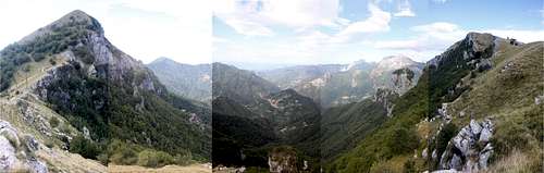
After an hour I pass the spring for water, the Rifugio and find a great
camp spot in the forest on the edge of a huge cliff above the Rifugio with
spectacular views of the Procinto Tower and the giant sheer wall of Monte Nona.
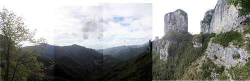
Sunday I’m up early to pack and climb the bolted and chained route of
La Ferrata del Procinto, stashing the pack below the climb in the thick forest.
After, I’ll descend to the spring near the rifugio and refill my five liters of
water then hike up to the pass Callare Matanna at the base of Monte Nona and
Monte Matanna. I should have enough water for a camp on one of the summits then
the next day descend to find the next water source.
From the pass I see the Garfagnana Valley and the Albergo Alta Matanna
just a short walk below.
Reaching the false summit I find it’s perfect for camp with room for
two tents and plenty of rocks nearby to help secure it from the wild wind. The
next section is only five minutes along the narrow rocky ridge to the summit.
It’s 12:00.
Monday morning coffee then half pack and have oatmeal. Complete the
packing then up to the summit for sunrise at 7:05 and over the top on the
narrow ridge trail along the sheer cliff. The trail mostly fades in the grass
and I study the folded grass marked by other boots passing by. I check my map
twice as I search for the best path trusting my instincts and soon reach the
forest and a few cairns then see a blue paint marker on a rock. I find trail
#109 and turn left soon arriving at the stone sanctuary hut and trail marker of
the pass, Foce delle Porchette at 8:15
I fork left on trail #6 down
towards Procinto and Fonte di Moscoso below the walls of Monte Nona with big
chutes of talus and boulders tearing down from above. I hear water flowing
below. Soon after, at 8:30 I reach a fork and trust the water I heard so I skip
more backtracking and the fork left to Fonte di Moscoso and I fork right
towards my goal of the pass, Foce di Petrasciana and Monte Forato. In just a
few turns at 8:40 I hear water and scramble fifty feet below the trail to where
water first begins to cascade from the broken blocks and mark the map.
The trail passes many fallen trees zig-zagging up the steep hillsides
reaching the pass, Foce di Petrasciana at 10:05. It’s a four way fork and I
take Trail #110 towards the bolted and chained route Ferrata Salvatori up the
Monte Forato Ridge. At 10:50 I reach the base of the Ferrata. It’s a steep,
nearly vertical exposed and broken extreme class three climb. The very start is
the worst part I can see. It looks beyond my level, at least with this big pack
but I’ll give it a try and find that red line.
I don’t complete the ferrata and am relieved reaching the ground but at
least I found that red line, that edge of experience and danger, where fear
keeps you thinking correctly and the skill helps to know where and when to stop
as there is always a next time.
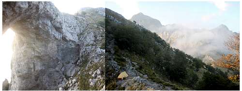
I hike slowly on the trial towards Passo dell’Arco. Arriving at the
space below the arch there’s a perfect sandy spot for camp and I see the trail
sign, EE #12 for Cardoso, descending steeply down below the arch.
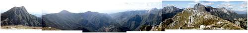
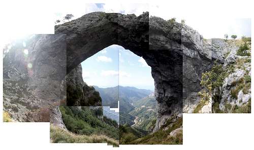
I continue up the steep ridge to reach the next summit with the big
cross. Monte Forato has two summits separated by the enormous arch. It’s 12:30
when I drop the pack on the sharp rocks of the summit.
Back down to the shade of the arch I rest, snack and study the map,
still wondering about this descent trail #12 marked EE, Escursionisti Esperti
and I wonder. It looks steep but it’s not a dotted line on the map, it’s solid
like the others.
At 5:15 a runner arrives from
below on this Trail #12 stopping at the sandy spot of the pass by me. I ask him
about the trail and if it’s safe. He says it’s no problem, a regular trail,
just really steep. Then he turns, as it’s getting cold and he descends down the
way he came below the arch and into the forest towards Cardoso clearly visible
two thousand feet below. I’m relieved now and secure for my morning descent.
I’m woken at 4:00am by the sounds of dogs howling from farms in the
eastern valley. I hope they aren’t the wild wolves that have been returned to
the wild this past year. At 5:40, by headlamp, I begin down the steep trail
below the arch into rough switchbacks and thick dark forest below stars.
It’s an amazing rough trail below big walls like a Sierra back country
route as I hold trees or grip a rock when needed as the trail twists and slides
very steeply down thick forest in total darkness.
I reach the village of Cardoso in two hours. The 8:32 bus arrives and I
buy a ticket from the driver and we continue on down the twisting valley
passing marble cutting factories towards the coast. Two trains, another bus and
I’m back in Volterra unpacking and cleaning gear in the sun on the farm. In
just a few days it’s another two trains and a weekend in Rome before returning
home to California.


Comments
Post a Comment